Printed on Satin finish 80# cover stock – 220 GSM. Made in the USA! Standard production time is 5 days. Allow more time for shipping.

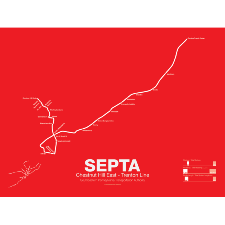
SEPTA Regional Rail R7: Chestnut Hill East – Trenton Line
Price range: $30.00 through $80.00
Additional information
| Weight | 1 lbs |
|---|---|
| Dimensions | 3 × 3 × 24 in |
| Size | Framed 18"x24", 18" x 24", 24" x 36 |
Related products
-
 Price range: $30.00 through $80.00
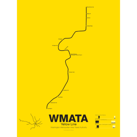
The Yellow Line was the fourth service of the Washington Metro to open and is today the shortest. Opened in 1983 connecting National Airport to Gallery Place the route acts as a bypass around downtown Arlington.
The route of the Yellow Line has deviated from the original planned route more than any other line. In December of 1983 the line was extended south to Huntington but was originally to run out to Franconia-Springfield (which didn’t open until 1997). A shortage of train cars caused this switch because the Yellow Line required fewer cars than the Blue Line which was routed out to Franconia-Springfield instead.
The Yellow Line was extended north to U St in 1991 but the final extension to Greenbelt was delayed because the original alignment along the median of the North Central Freeway was changed when that freeway was canceled. A new subway connection from U St to Fort Totten, the route subject to much controversy, was eventually opened in 1999 for Green Line service and in 2006 the Yellow Line was extended to Fort Totten.
Today the Yellow Line shares most of its route through Virginia with the Blue Line and all of its route through D.C. with the Green Line.
Printed on Satin finish 80# cover stock – 220 GSM. Made in the USA! Standard production time is 5 Days. Please add more time for shipping.
Select options This product has multiple variants. The options may be chosen on the product page -
 Price range: $30.00 through $80.00
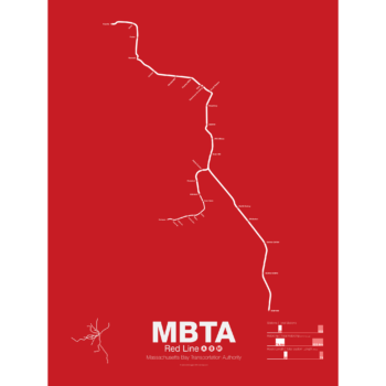
In 1912 the Red Line benefited from being the last of the original subways in Boston to open. A decade of subway building allowed the Red Line to be designed with larger trains and platforms that were easier to navigate (unlike the disconnected Orange Line platforms). Planned as an elevated subway until the citizens of Cambridge objected, the original route connected Harvard Sq. with Park St. At Harvard Sq. a parallel subway was built for trolleys to transfer commuters from the northwestern suburbs and is still in use today.
The Red Line was quickly extended to South Boston and large transfer stations were built at Broadway and Andrew Sq. to collect trolley (and later bus) commuters coming from Dorchester.
In 1926 and 1927 the Red Line was extended to Ashmont in Dorchester along the route of and old commuter rail road. Though the subway was proposed to be extended further to Mattapan the residents of Milton and southern Dorchester opted for a high speed trolley route instead, pre-dating the concept of light rail.
Plans were drawn up to create a new branch of the Red Line to Braintree as early as 1945 but construction didn’t begin for another 20 years. First to Quincy in 1971 and finally to Braintree in 1980 the new branch was designed to bypass Dorchester for a quicker commute.
At the other end the Red Line was extended northwest from Harvard Sq. to Alewife in 1985. Originally planned to run out to Lexington along the abandoned Boston and Maine Railroad the line was cut back when residents of Arlington protested.
The Red Line runs two heavy rail routes, Alewife-Ashmont and Alewife-Braintree (which skips Savin Hill).
A light rail section runs from Ashmont to Mattapan using refurbished PPC trolleys from the 1940s.
Printed on Satin finish 80# cover stock – 220 GSM. Made in the USA! Standard production time is 5 Days. Please allow more time for shipping.
Select options This product has multiple variants. The options may be chosen on the product page -
 Price range: $30.00 through $80.00
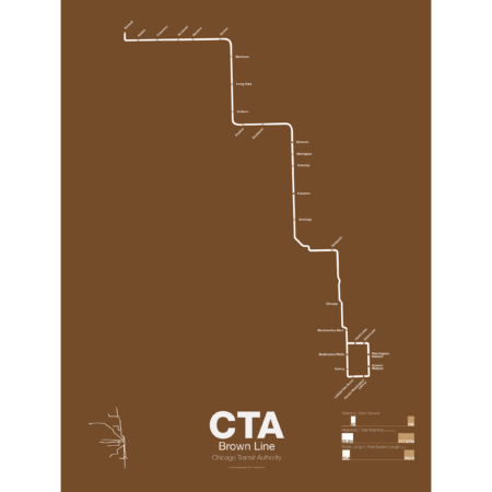
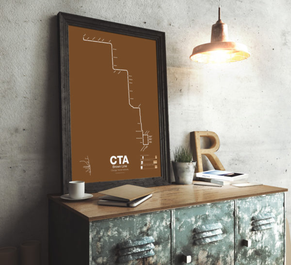
The Brown Line began as the Northwestern Elevated in 1907 and runs from its terminal at Kimball to the Loop and back, making a zig-zag through the northwest section of the city. At the terminal at Kimball trains run at street level with third-rail power which is rare for transit in the US and extremely dangerous for pedestrians. Brown Line trains run local with Red Line trains from Belmont to Fullerton. Recently the stations of the Brown Line were expanded and upgraded to be ADA compliant to deal with rapid population growth on the north side.
Printed on Satin finish 80# cover stock – 220 GSM. Made in the USA! Standard production time is 5 Days. Please add more time for shipping.
Select options This product has multiple variants. The options may be chosen on the product page -
 Price range: $30.00 through $80.00
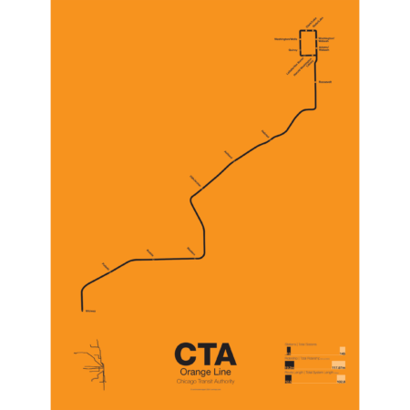
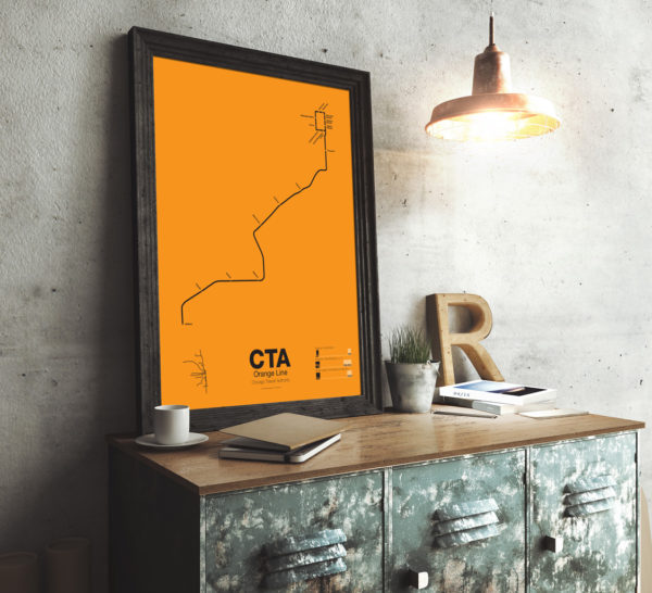
First proposed in the 1930s but only opened in 1993 the Orange Line serves the southwest section of Chicago and terminates at Midway Airport. Funding for the line was secured after the cancellation of the controversial Crosstown Expressway. For much of the route the Orange Line runs parallel to CSX and Conrail tracks but connects to the Loop in downtown Chicago. The original terminal at Ford City Mall was cut back due to cost savings but current studies are underway to extend the Orange Line past Midway to the mall.
Printed on Satin finish 80# cover stock – 220 GSM. Made in the USA! Standard production time is 5 Days. Please add more time for shipping.
Select options This product has multiple variants. The options may be chosen on the product page