Printed on Satin finish 80# cover stock – 220 GSM. Made in the USA! Standard production time is 5 days. Allow more time for shipping.
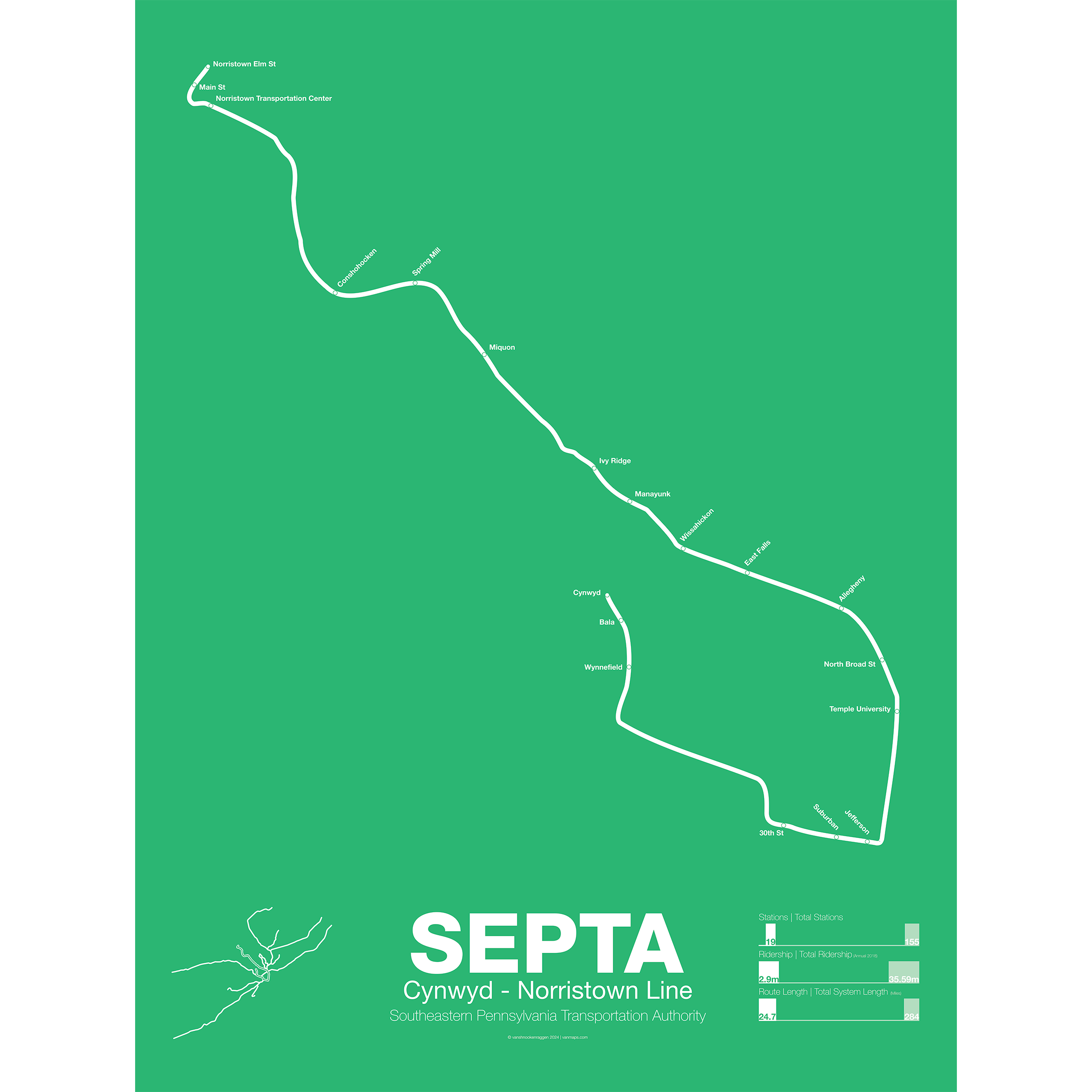
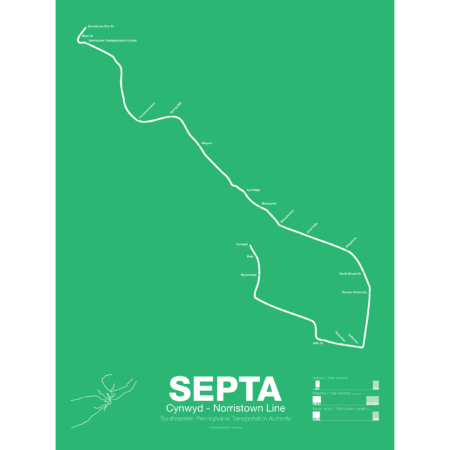
SEPTA Regional Rail R6: Cynwyd – Norristown Line
$30.00 – $80.00
Additional information
| Weight | 1 lbs |
|---|---|
| Dimensions | 3 × 3 × 24 in |
| Size | Framed 18"x24", 18" x 24", 24" x 36 |
Related products
-
 $30.00 – $80.00
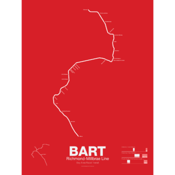
The Bay Area Rapid Transit system (BART) was, along with the WMATA in Washington D.C., one of the great centrally planned post-war rapid transit systems aimed at addressing the rise of the highway and auto-centric suburbs after World War II in the United States. Planning began in the 1950s for a unified high speed rail system that would serve both the dense inner cities of San Francisco and Oakland and their newly expanding low-rise suburbs. Stations would be spaced closer in the central business districts and further out in the suburbs.
Originally planned to connect Alameda, Contra Costa, Marin, San Francisco, and San Mateo counties BART was scaled back when San Mateo dropped out in favor of commuter rail service and the Marin line was dropped due to engineering concerns about running a rail line over the Golden Gate Bridge. Construction began in 1964 and the initial segments began to come online in 1972 and the majority of the system opening by 1974.
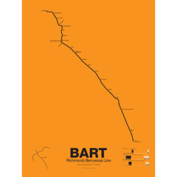
The Richmond-Warm Springs Line, also known as the East Bay Line, is the only line that does not enter San Francisco running from Richmond in the north through Oakland to Fremont in the south. Like most BART lines the Richmond-Fremont Line shares its tracks with other BART lines: the Richmond-Millbrae Line, the Pittsburg/Bay Point–SFO/Millbrae Line, the Fremont–Daly City Line, and the Dublin/Pleasanton–Daly City Line.
The Richmond–Fremont Line was the first of BART’s five lines to open. Service from MacArthur to Fremont began on September 11, 1972, the first day of BART operation and was extended to Richmond on January 29, 1973.
Construction has begun on a southern extension to San Jose; the first phase to Warm Springs/South Fremont opened in 2017 with the second phase to Milpitas and Berryessa opening in 2020.
Printed on Satin finish 80# cover stock – 220 GSM. Made in the USA! Standard production time is 5 days. Allow more time for shipping.
Select options This product has multiple variants. The options may be chosen on the product page -
 $30.00 – $80.00
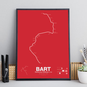
The Bay Area Rapid Transit system (BART) was, along with the WMATA in Washington D.C., one of the great centrally planned post-war rapid transit systems aimed at addressing the rise of the highway and auto-centric suburbs after World War II in the United States. Planning began in the 1950s for a unified high speed rail system that would serve both the dense inner cities of San Francisco and Oakland and their newly expanding low-rise suburbs. Stations would be spaced closer in the central business districts and further out in the suburbs.
Originally planned to connect Alameda, Contra Costa, Marin, San Francisco, and San Mateo counties BART was scaled back when San Mateo dropped out in favor of commuter rail service and the Marin line was dropped due to engineering concerns about running a rail line over the Golden Gate Bridge. Construction began in 1964 and the initial segments began to come online in 1972 and the majority of the system opening by 1974.
The Richmond-Millbrae Line, also known as the Richmond Line, was the fourth line to open in the BART system starting limited service in 1976. Because the Richmond Line shares its entire route with other BART lines it stops operations at 8pm on weekdays and 7pm on Saturdays. Originally terminating at Daly City the line was extended south in 2004 to SFO/Millbrae when that extension was opened sharing the line with the Pittsburg/Bay Point–SFO/Millbrae Line.
Printed on Satin finish 80# cover stock – 220 GSM. Made in the USA! Standard production is 5 Days. Please allow more time for shipping.
Select options This product has multiple variants. The options may be chosen on the product page -
 $30.00 – $80.00
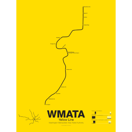
The Yellow Line was the fourth service of the Washington Metro to open and is today the shortest. Opened in 1983 connecting National Airport to Gallery Place the route acts as a bypass around downtown Arlington.
The route of the Yellow Line has deviated from the original planned route more than any other line. In December of 1983 the line was extended south to Huntington but was originally to run out to Franconia-Springfield (which didn’t open until 1997). A shortage of train cars caused this switch because the Yellow Line required fewer cars than the Blue Line which was routed out to Franconia-Springfield instead.
The Yellow Line was extended north to U St in 1991 but the final extension to Greenbelt was delayed because the original alignment along the median of the North Central Freeway was changed when that freeway was canceled. A new subway connection from U St to Fort Totten, the route subject to much controversy, was eventually opened in 1999 for Green Line service and in 2006 the Yellow Line was extended to Fort Totten.
Today the Yellow Line shares most of its route through Virginia with the Blue Line and all of its route through D.C. with the Green Line.
Printed on Satin finish 80# cover stock – 220 GSM. Made in the USA! Standard production time is 5 Days. Please add more time for shipping.
Select options This product has multiple variants. The options may be chosen on the product page -
 $30.00 – $80.00
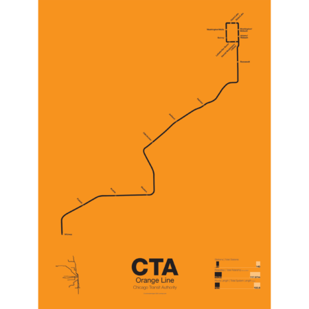
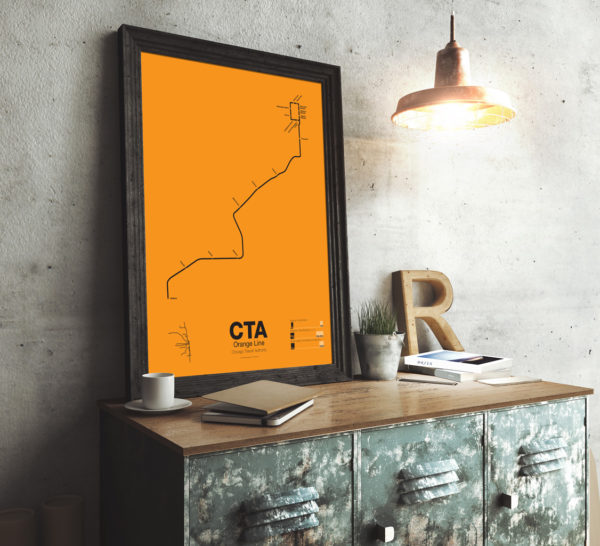
First proposed in the 1930s but only opened in 1993 the Orange Line serves the southwest section of Chicago and terminates at Midway Airport. Funding for the line was secured after the cancellation of the controversial Crosstown Expressway. For much of the route the Orange Line runs parallel to CSX and Conrail tracks but connects to the Loop in downtown Chicago. The original terminal at Ford City Mall was cut back due to cost savings but current studies are underway to extend the Orange Line past Midway to the mall.
Printed on Satin finish 80# cover stock – 220 GSM. Made in the USA! Standard production time is 5 Days. Please add more time for shipping.
Select options This product has multiple variants. The options may be chosen on the product page