map
-
 $325.00 – $450.00
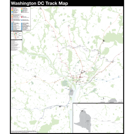
The Complete and Geographically Accurate track map of Washington DC is a new, detailed look at the entire rail network that most riders never see. Unlike a traditional subway map which just shows train routes, stations, and a simplified geography for easier navigation, the Track Map shows how the system actually looks; each track, each switch, each station platform and each train yard is shown in a clear and clean design. While the Track Map offers a service guide, it is not intended to replace the subway map as a wayfinding tool. The Track Map shows the paths of the tracks so that the viewer can see how trains are able to run. If you’ve ever wondered why certain trains don’t run to certain places, this map will tell you why.
The idea behind this was to remove all distortion from traditional subway maps and see the system down to its bones. Street labels, parks, cemeteries, and airports help act as landmarks. The more complicated interchanges and interlockings are shown in a blown up detail section along with a list of as many provisions and abandoned sections of the system I have discovered.
Fine art prints are made in Williamsburg, Brooklyn NY on Semi-Gloss, 10mil Premium Luster Paper.
Select options This product has multiple variants. The options may be chosen on the product page -
 $45.00
“I defy anyone to take this psychedelic creation and figure out how to get anywhere!” -State Senator Albert B. Lewis 1967.
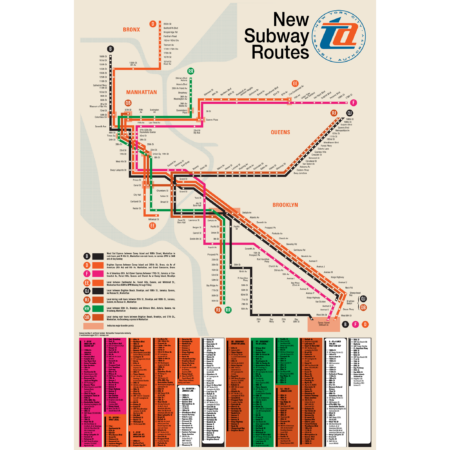
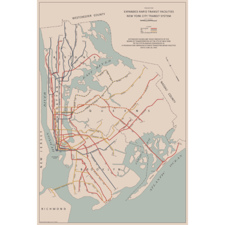
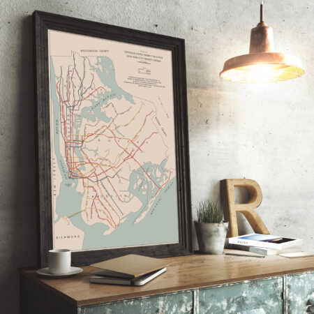
The Chrystie Street Connection didn’t just revolutionize how commuters got around by creating new subway lines but it also helped usher in a new era of modernist wayfinding and system maps. Chrystie St took a decade to build and knit together the once separate BMT and IND subway systems to create a new network which we still use today. This map was part of a brochure issued when the first new lines were opening in November 1967. This map was the first to introduce the idea that each line would be shown with its own color and lettered bullet, simplifying naming conventions. For a further look at the Chrystie St Connection check out my blog post!
This map has been carefully recreated down to the exact typeface. Included at the bottom was the reverse side of the original brochure, featuring a station by station listing of each new line. Printed on Satin finish 80# cover stock – 220 GSM, 24″ x 36″.
-
 $45.00
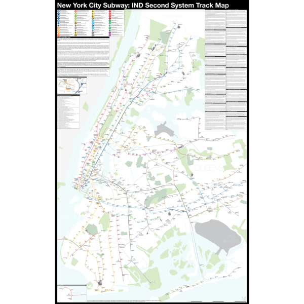
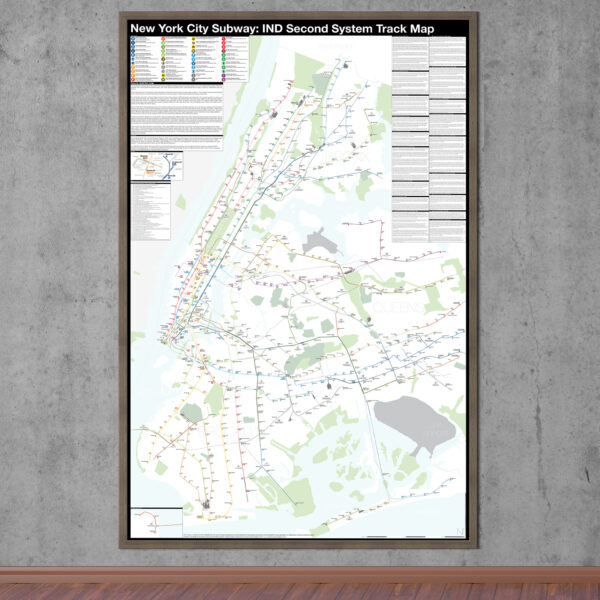
There are two “official” maps of the IND Subway’s expansion plans from the 1930s, colloquially known as the Second System. The plans for expansion evolved greatly as the IND was built. In the 1930s, the New York City subways were still operated by three separate companies. In 1940 the two private companies, the IRT and BMT were purchased by the City of New York under a unification plan. Thus, subway planners were able to imagine physically combining the three systems.
In 1940, John Delaney, Chairman of the Board of Transportation, outlined a new plan, with some additions in 1943. Until now, there were no maps of this plan. So I made one! The 1943 Lost IND Second System Map is probably the last time the city thought about such a large expansion program. The map here is based on the design of the 1939 map, with some changes.
To learn more about the history of this map, and see an outline of the ideas it shows, check out my post.
Printed on Satin finish 80# cover stock – 220 GSM, 24″ x 36″.
-
 $375.00 – $500.00
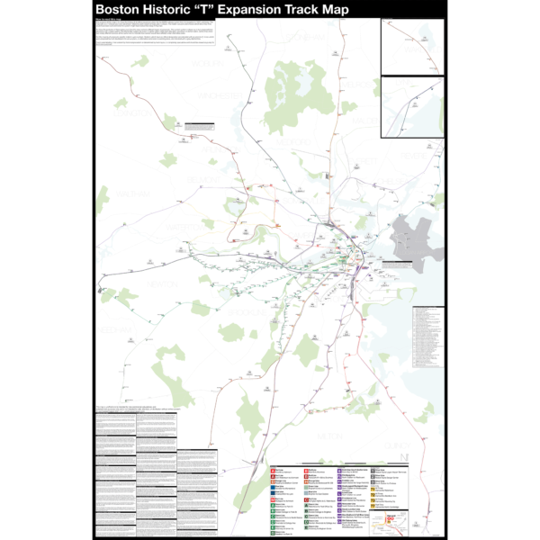
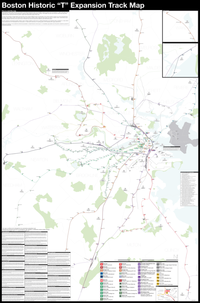
Boston opened the first subway in the US in 1897 and immediately began expanding it. Since then numerous plans have been drawn up, some are simple extensions while others are whole sale reimaginations of the subway. This map shows in detail each official proposal with the history of each idea.
The map acts as a “choose your own adventure” where by each variant of every plan is drawn. The reader can pick and choose which lines they think could have been built and what the system might have looked like today if they had.
Fine art prints are made in Williamsburg, Brooklyn NY on Semi-Gloss, 10mil Premium Luster Paper.
For more information about the map see the original blog post here.
Select options This product has multiple variants. The options may be chosen on the product page -
 $375.00 – $500.00
The Independent City-owned Subway System, IND, was created as alternative to the private traction companies, Interborough Rapid Transit Co., IRT, and the Brooklyn-Manhattan Transit Co., BMT. The IND broke ground on the 8th Ave Line in 1925 with plans for lines to Queens, Brooklyn, and the Bronx. In 1929 the IND released an ambitious plan for expanding the initial system. This plan became known as the IND Second System. In 1940 the City of New York was able to purchase the private companies and combine all three systems under the NYC Board of Transportation. In 1953 this evolved into the NY Transit Authority and in 1968 the state took control of the subways as part of the Metropolitan Transportation Authority.
The purpose of this map is the show the history of official subway expansion plans which can be broadly broken down into four phases: the 1929 Second System plan, the 1939 Second System plan, post-World War II plans, and the 1968 MTA Plan for Action.
The map acts as a “choose your own adventure” where by each variant of every plan is drawn. The reader can pick and choose which lines they think could have been built and what the system might have looked like today if they had.
Fine art prints are made in Williamsburg, Brooklyn NY on Semi-Gloss, 10mil Premium Luster Paper.
For more information about the map see the original blog post here.
Select options This product has multiple variants. The options may be chosen on the product page -
 $375.00 – $500.00
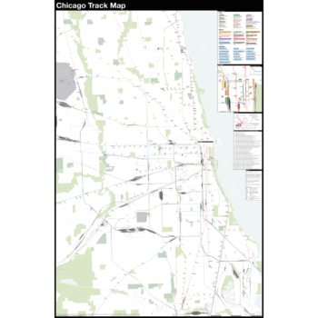
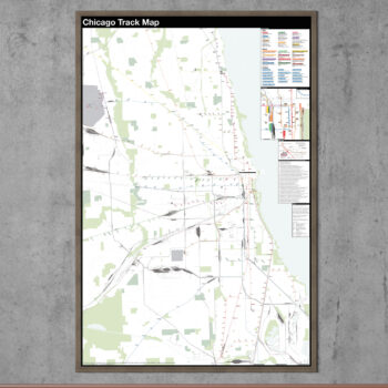
The Complete and Geographically Accurate track map of Chicago is a new detailed look at the entire rail network that most riders never see. Unlike a traditional subway map which just shows train routes, stations, and a simplified geography for easier navigation, the Track Map shows how the system actually looks; each track, each switch, each station platform and each train yard is shown in a clear and clean design. While the Track Map offers a service guide it is not intended to replace the subway map as a wayfinding tool. The Track Map shows the paths of the tracks so that the viewer can see how trains are able to run. If you’ve ever wondered why certain trains don’t run to certain places this map will tell you why.
The idea behind this was to remove all distortion from traditional subway maps and see the system down to its bones. Street labels, parks, cemeteries, and airports help act as landmarks. The more complicated interchanges and interlockings are shown in a blown up detail section along with a list of as many provisions and abandoned sections of the system I have discovered.
Fine art prints are made in Williamsburg, Brooklyn NY on Semi-Gloss, 10mil Premium Luster Paper.
For more information about the map see the original blog post here.
Select options This product has multiple variants. The options may be chosen on the product page -
 $30.00 – $80.00
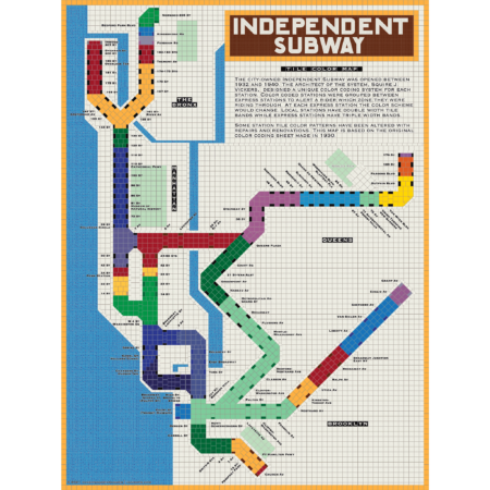
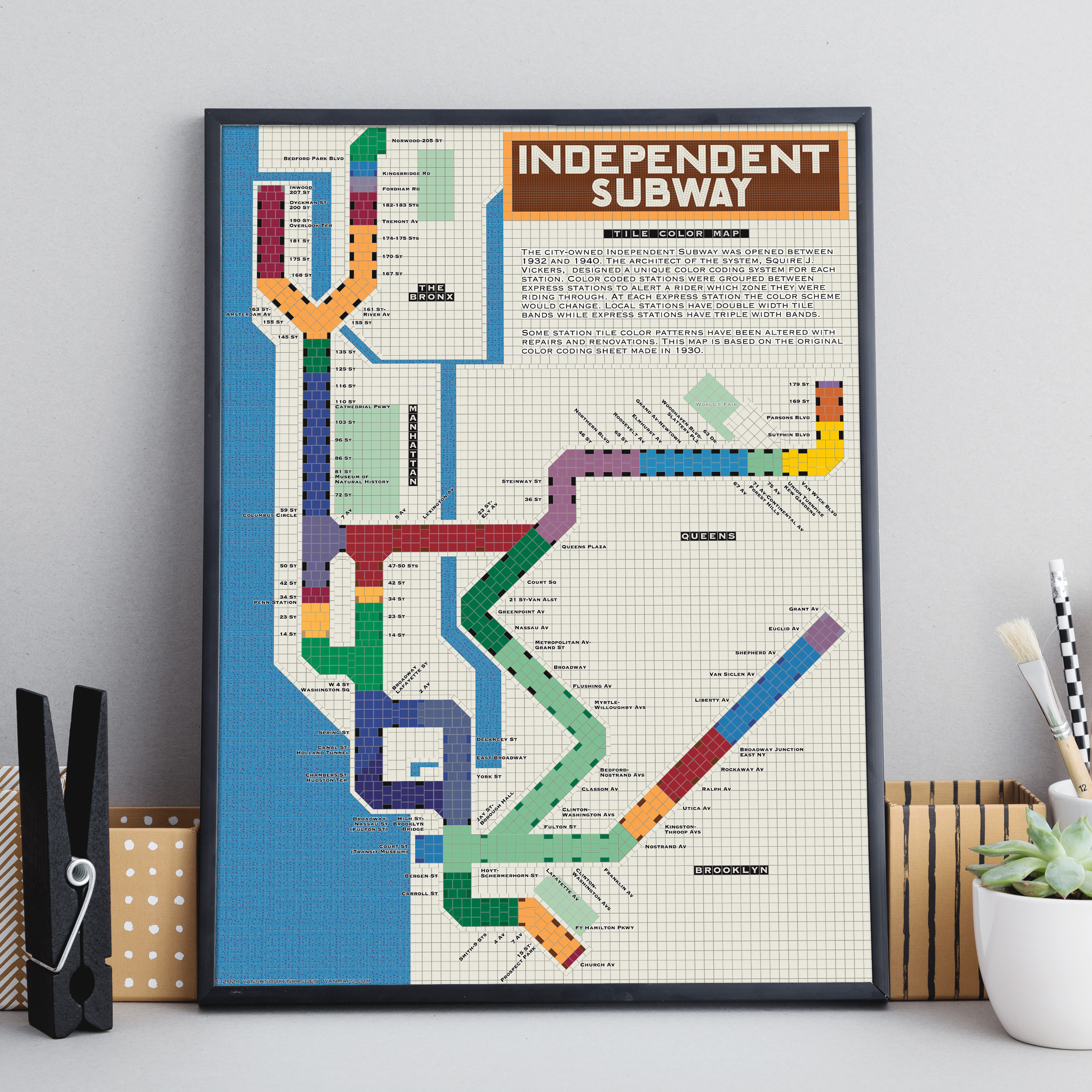
The City of New York built Independent Subway (A/B/C/D/E/F/G trains) was opened between 1932 and 1940. All the subway stations at the time featured tile bands and art unique to each station. The IND’s architect, Squire Vickers, created a new tile pattern based on color theory. He grouped express and local stations with color so that each time a rider rode through an express station the color of the tiles would change. He created a modern, streamlined design which featured two colors per station. The idea was that a rider would recognize their station’s color and know when to get off. This map shows how each color group looks when laid out like a subway map.
Note: The design features an orange tile outline. Some frames may obscure this outline.
Printed on Satin finish 80# cover stock – 220 GSM, 18″ x 24″.
Select options This product has multiple variants. The options may be chosen on the product page -
 $30.00 – $80.00
Printed on Satin finish 80# cover stock – 220 GSM. Made in the USA! Standard production time is 5 Days. Please add more time for shipping.
Select options This product has multiple variants. The options may be chosen on the product page -
 $30.00 – $80.00
Printed on Satin finish 80# cover stock – 220 GSM. Made in the USA! Standard production time is 5 Days. Please add more time for shipping.
Select options This product has multiple variants. The options may be chosen on the product page -
 $30.00 – $80.00
Printed on Satin finish 80# cover stock – 220 GSM. Made in the USA! Standard production time is 5 Days. Please add more time for shipping.
Select options This product has multiple variants. The options may be chosen on the product page -
 Out of Stock
$30.00 – $80.00
Out of Stock
$30.00 – $80.00
Printed on Satin finish 80# cover stock – 220 GSM. Made in the USA! Standard production time is 5 Days. Please add more time for shipping.
Select options This product has multiple variants. The options may be chosen on the product page -
 Out of Stock
$30.00 – $80.00
Out of Stock
$30.00 – $80.00
Printed on Satin finish 80# cover stock – 220 GSM. Made in the USA! Standard production time is 5 Days. Please add more time for shipping.
Select options This product has multiple variants. The options may be chosen on the product page -
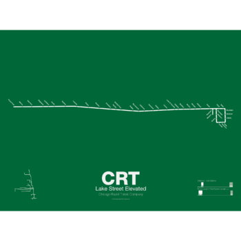
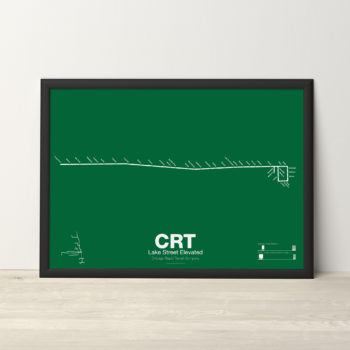 $30.00 – $80.00
The Lake Street Elevated was Chicago’s second elevated line opening in 1893. In 1993 the CTA reorganized routes and color coded the new Lake St-South Side Lines as the Green Line.
Printed on Satin finish 80# cover stock – 220 GSM. Made in the USA! Standard production time is 5 Days. Please add more time for shipping.
Select options This product has multiple variants. The options may be chosen on the product page -
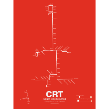
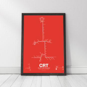 $30.00 – $80.00
The South Side elevated opened in 1892 to serve the Columbian Exposition in 1893 and led to a building boom on the south side of Chicago. A number of branches were added to the line, to Englewood, Normal Park, Kenwood, and the Stock Yards. Today only the Englewood and Jackson Park branches remain while a number of stations have been closed due to low ridership.
Printed on Satin finish 80# cover stock – 220 GSM. Made in the USA! Standard production time is 5 Days. Please add more time for shipping.
Select options This product has multiple variants. The options may be chosen on the product page -
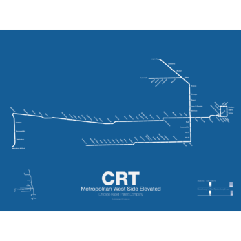
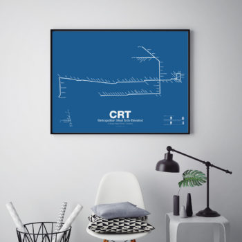 $30.00 – $80.00
In 1895 the Metropolitan West Side Elevated Railroad began with service from Canal St to Logan Sq. Soon branches were added to Garfield Park, Humboldt Park, and Douglas Park. The Met, as it was known, has seen the most dramatic changes of all the Chicago “L” lines: the Humboldt Park and Logan Sq branches were removed when service was rerouted through the new Milwaukee-Dearborn Subway in 1951 and subsequently extended along the Kennedy Expressway to Jefferson Park in 1970 and then to O’Hare Airport in 1984. The Garfield Park branch was completely rebuilt along the median of Interstate 290 in 1958. In 2008 the Douglas Branch was rerouted along the Paulina Connector (a left over section of track from the old Logan Sq branch) to connect to the Loop and rebranded as the Pink Line.
Printed on Satin finish 80# cover stock – 220 GSM. Made in the USA! Standard production time is 5 Days. Please add more time for shipping.
Select options This product has multiple variants. The options may be chosen on the product page -
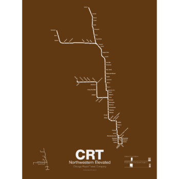
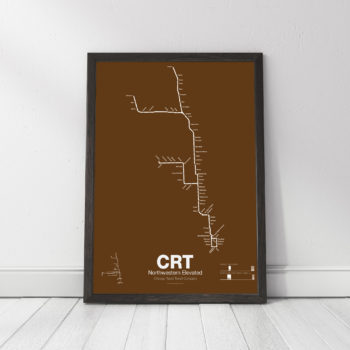 $30.00 – $80.00
The Northwestern Elevated opened in 1907 and ran from a terminal on North Water St before it connected to Loop. The Main Line ran north to Evanston and a branch was built to Kimball. When the Northwestern was consolidated into the Chicago Rapid Transit Commission a second branch to Skokie was connected which once allowed interurban trains to run from the Loop to Milwaukee. The Northwestern division was split into the Brown, Purple, Yellow, and Red Lines.
Printed on Satin finish 80# cover stock – 220 GSM. Made in the USA! Standard production time is 5 Days. Please add more time for shipping.
Select options This product has multiple variants. The options may be chosen on the product page