The futureNYCSubway series was never supposed to live this long. It was supposed to have been a one-off, much like my previous futureMBTA series. I would then move on to other cities. But, I didn’t. Every time I dug under the surface, I found more to talk about.
The initial “plan” was simply a collection of historical ideas with my own spin on them. Then I went wild with it. While there are now a half dozen different published versions, I have dozens more which will never see the light of day. I used these as test grounds for new ideas and new drawing techniques.
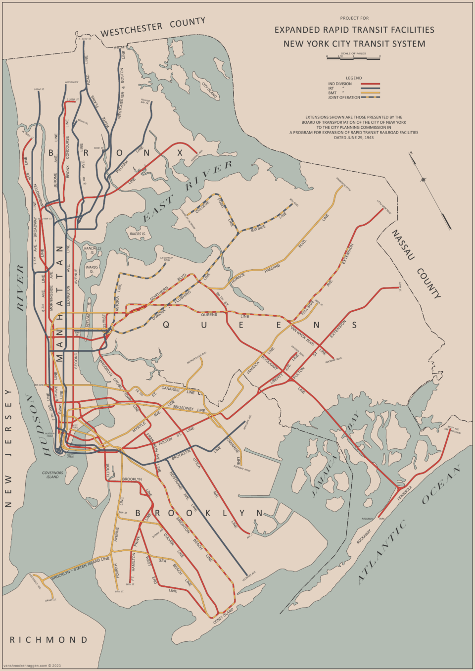
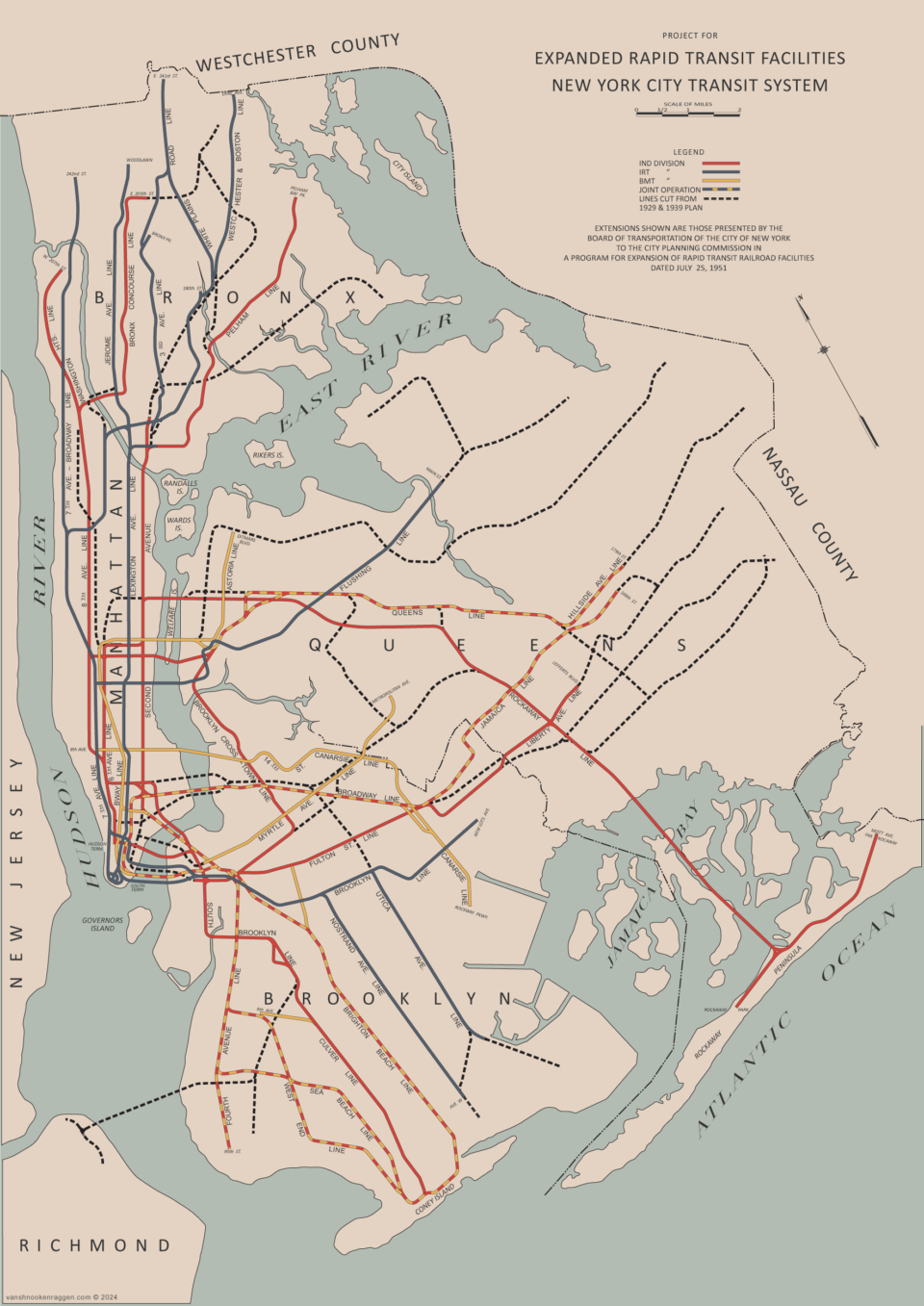
At some point I realized there were no new ideas. I decided to go back to the beginning and discover the stories behind these failed dreams. I am no longer interested in large-scale plans, full of crayon lines. Instead, I want to understand each idea on its own, usually through a miniseries of posts.
I have been asked if I stand by many of my old ideas. Some were great 100 years ago, 20 years ago, and today. Some have not aged well. I leave these posts as written history to educate and inspire the next generation of planners and historians.

Invitation to staff
TRANSIT MOVIES SHOW Friday November 21 7 pm Manhattan location free event
view details at http://www.erausa.org phone 631 875 4038
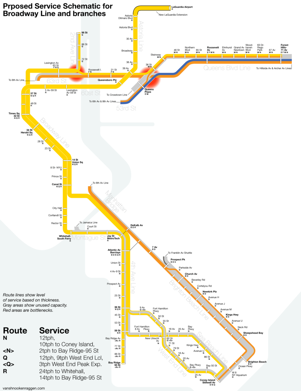
Your extension of the N to LAG should not go down Ditmars Bvd. For one thing, the sharp right turn at 31st and Ditmars is physically impossible. It needs to continue up 31st past 20th Ave, than right turn to 19th Ave, to the airport.
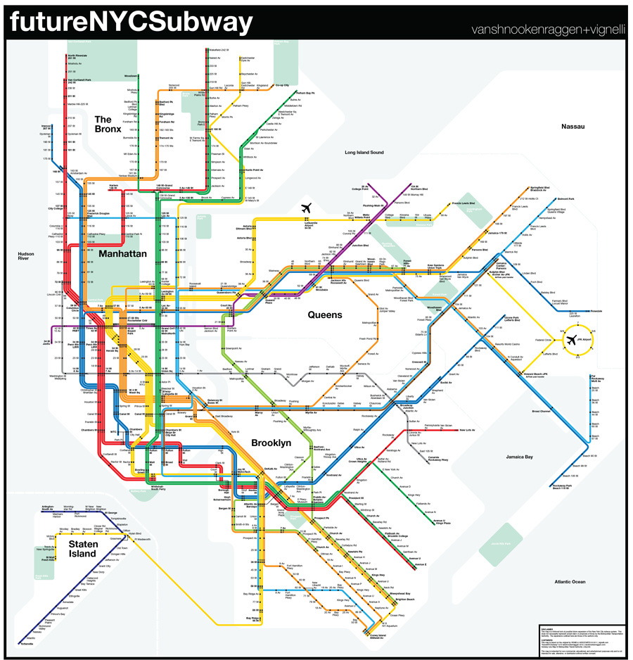
Umm…label the stops so we know what names you have for your future stations.
Also, I can’t tell the difference between original stops and new added stops.
I think there should be a line from the 7 at 111th St or Mets/Willet Point(and even better – LaGuardia) to E,F,A,V and H and M at Union Turnpike. I believe such a line existed during the 1939 world fair. https://en.wikipedia.org/wiki/IND_World's_Fair_Line If from LaGuardia it would provide access to the south and reduce the traffic on the #7 when folks have to backtrack to 74th St Broadway to catch the E,F, etc
Maybe include a stop at Queens College – from Citi Field through Queens College to Union Turnpike comes to 3.15 miles. Of course, it would be underground.
BEFORE I RETIRED, I WORKED IN LONG ISLAND CITY. I WAS CONSTANTLY RIDING THE E & G-TRAINS TO AND FROM MY JOB. I SPENT A LOT OF TIME WONDERING WHEN AND WHERE THE G-TRAIN WOULD GO IN MANHATTAN, IF IT EVER DID. WELL WONDER NO MORE, THAT BECAME OVIOUS WHEN THE 7-TRAIN ROUTE WAS EXTENDED. DID YOU FIGURE IT OUT? THE ANSWER IS: PAIR-UP THE F & M-TRAINS ON 63RD STREET AND THE E & G-TRAINS ON 53RD STREET. THE E,F & M-TRAIN DESTINATIONS REMAIN THE SAME AND THE G-TRAIN CONTINUES SOUTH ON ITS ORIGINAL ROUTE. THE ENTIRE NEW ROUTE FOR THE G-TRAIN WOULD BE: 2ND AVENUE & HOUSTON STREET VIA SIXTH AVENUE IN MANHATTAN-TO-CHURCH AVENUE IN BROOKLYN. IF THE NEED ARISES, THE F-TRAIN WOULD GO EXPRESS IN BROOKLYN BYPASSING CARROLL, SMITH, 4TH AVENUE, 15TH STREET AND FORT HAMILTON. THE ONLY THING NECESSARY IS TO RECONFIGURE THE UPPER-LEVEL OF THE COURT STREET STATION SO THAT THE G-TRAIN HAS A DIRECT CONNECTION TO DO THIS. THIS WOULD BE THE CHEAPEST AND ONLY ALTERNATIVE.
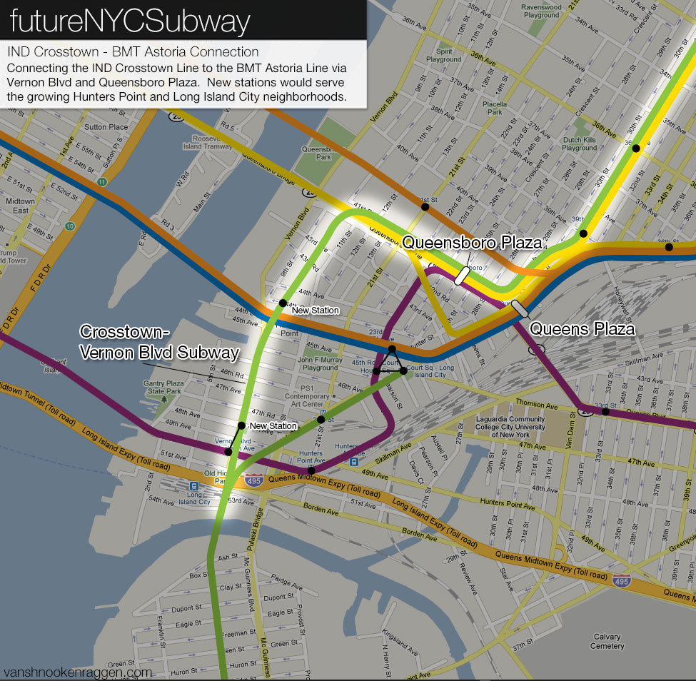
WHEN THE COURT SQUARE STATION IS REFIGURED, IT MUST INCLUDE PROVISIONS FOR THE K-TRAIN AS EITHER A TERMINAL OR AN EXTENSION TO QUEENS PLAZA AND BEYOND.
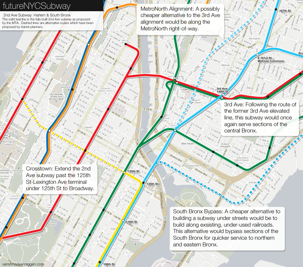
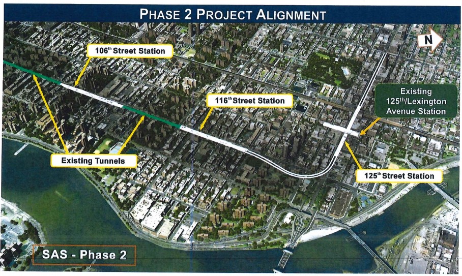
IT IS HARD FOR ME TO BELIEVE THAT THE S.A.S. COULD EVER BE DESIGNED WITH A X-TOWN 125TH STREET TURNOUT IN 1940. TURNOUTS FOR EXPANSION TO THE BRONX, QUEENS AND BROOKLYN I CAN SEE, BUT NOT MANHATTAN. DON’T FORGET, AT THAT TIME, THE LEXINGTON AVENUE LINE WAS RUNNING AND IT BLOCKED ANY MOVE TO THE WESTSIDE AND STILL DOES TODAY. HOW PLANNERS COULD OVERLOOK THIS IS HARD TO KNOW, BUT THEY DID. LUCKILY, THERE IS STILL TIME TO CORRECT THIS BLUNDER. SINCE THE Q-TRAIN IS NOW RUNNING, (1/1/17) THE COMMITMENT SHOULD NOW FOCUS ON THE BRONX, NOT THE X-TOWN 125TH STREET LINE. SINCE THE ONLY TWO-TRAINS WE’LL ARE THE Q & T-TRAINS, PHASE-2 MUST INCLUDE EVERYTHING FROM 106TH STREET-TO-149TH STREET. ONCE YOU GET TO 149TH STREET, THERE ARE TWO-DIRECTIONS YOU CAN GO NORTH. MELROSE/WEBSTER OR THIRD AVENUE BOTH TO TREMONT AVENUE AND THEN EAST. I CALL THEM MY “INSIDE” ROUTES. THE 2, 5 & 6-TRAINS BEING THE OUTSIDE ROUTES. PHASE-3 SHOULD BE EVERYTHING LEFT BETWEEN 161ST STREET & EAST 180TH STREET, NOT 63RD STREET-TO-HOUSTON STREET. THAT DONE, YOU CAN NOW FINISH LOWER MANHATTAN SOUTH OF 63RD STREET WITH 3 IF NOT 4-TRACKS. ITS MY CHOICE, BUT I FAVOR THE Q-TRAIN TERMINATING AT 125TH STREET & SECOND AND THE T-TRAIN GOING INTO THE BRONX WHEN THEY BOTH ARE RUNNING. CONNECTIONS/TRANSFERS BETWEEN PARK, LEXINGTON & SECOND AVENUES ON 125TH STREET CAN BE DONE WITH AN AUTOMATED LEVEL-ONE MOVING SIDEWALK. WHY DIG DOWN FIVE-LEVELS JUST TO ACCOMPLISH THE SAME THING AND WAIT ANOTHER GOD KNOWS HOW MANY DECADES TO COMPLETE? IF THE IDEA HERE IS TO EVENTUALLY HAVE THE Q OR T-TRAINS INTERGRATED WITH THE A, B, C OR D-TRAINS GOING UPTOWN, THATS A BAD IDEA. THERE ARE VERY FEW PEOPLE THAT TRANSFER FROM METRO-NORTH TO A SUBWAY TODAY SO WHY WOULD TOMORROW BE ANY DIFFERENT?
I’m curious on why the triboro rx has to be one line. why cant it be an extension of many lines?for example the B could use the part from 161 st to Jackson heights-Roosevelt avenue.
also on the sas how are you going to have 4 trains running on 2 tracks
It would have 4 tracks.
question:would it be smart to do the following on the queens blvd line:
-have 3 local trains, the E,M,R on the line
-have 3 express trains, the A,F,W on the same line
-have the A/E go to Jamaica Center
-have the R/W go to Forest Hills
-have the F/M go to 179 st
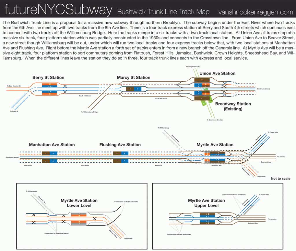
I know that the Queens Blvd line is extremely congested,but this would make it similarliy to the bushwick trunk line and would greatly serve midtown
I made a mistake I meant the e and h train
service would run as follows:
phase 1-change the w train to express service from 57 street to forest hills making stops at 63rd street,21st street,jackson heights and forest hills and switch the e to local service .also extend the m train to 179 street
phase 2-revive the h train from franklin ave on the s train,then after prospect park will run local on the q line then at coney island will loop to atlantic ave via the d line,then at west 4 street will switch to the a c and e line. after 50th street a new tunnel would run under the n q r and w train at 57 st 7 av then connect with the f and w at 63rd street and run parallel to the f and w to forest hills then follow the e to Jamaica center.service might be a little slower but passangers would greatly benefit from it
the Q would replace the W and a new shuttle train would run from 125 St[if made before phase 2 of the sas then 96 st]and the h train would use the 53rd st tunnel with the m and the r and w would join the f train through 63rd street tunnel for budget cuts . due to these changes the following will be in effect until the tunnels are built
H:at west 4 trains will switch to the 6th ave line and will run via the f to briarwood then follow the e train to Jamaica supthin archer
f trains will run as normal
R:on weekdays trains will run via 63rd street then switch to the local track.late nights and weekends at dekalb ave trains will run via the d to bdwy laffayette then switch to the local tracks.at 47 50 sts the train will join the the 53rd st tunnel and run via the e and m trains to forest hills
W:weekdays will join the 63rd street tunnel and run via the f train to forest hills.late nights and weekends trains will be extended to bay ridge 95 street[4th ave local].service going towards queens will remain the same as weekday service
f m and e trains service will remain the same
n and q trains wil now have 2 northern terminals.also this will result in 2 extra services:local n and local q ,and express n and express q. express n and q will be the regular service.local n and q will run from 96 street to coney island . local n and q will run from Astoria dimtars blvd to coney island.
by tunnels I meant the 2 new tunnels:the tunnel connecting the r train from either 42 or 49 st to the 53rd street tunnel and the tunnel from 50th st to 57th street[n q w]then would join the tunnel from 57 st 7 av to the 63rd street tunnel with the f and w
1. Avenue C. On Avenue C & 14 Street there should be a new station called Avenue C.
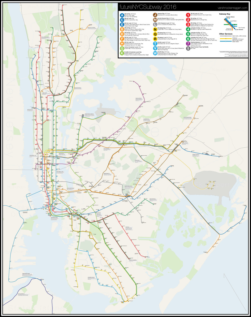
2. Instead of abandoning the Jamaica Avenue Line you should make the P train head up Jamaica Avenue like the D dose in FutureNYCSubway 2016.
3. I think the 1 should exstend from 242 Street to 261 Street.
4. The 7 should stop at 23 Street & 11 Avenue called 23 Street – Chelsea Piers.
5. Make the 6 or the 8 go down to Bowling Green.
What do you think of these. Do you think there good. Please tell me the awnser please.
1) Ave C isn’t a good place for a station. First the tunnel is angled too much so the platforms would be slanted and second half the catchment area is water so you are wasting potential. An entrance at Ave A and 14th St to the existing station is all that is needed.
2) That’s why I moved the D over.
3) Good idea.
4) Same as point 1, half the catchment is water so it would be a waste.
5) Not enough space. From 4 tracks to 2 there isn’t enough room.
Hey, Your website looks REALLY NICE with this new design.
One Question though. When is the Next FutureNYCsubway gonna come out, similar to the first one, Versions 2-4 and FutureNYCsubway2016???
WIll it be called FututreNYCsubway2017 or 2018???
Thank you so much! I’m really happy with it. Truthfully I don’t know. I had planned on doing one after the track map was finished but with the subway falling apart I’m going to focus on a deeper look at the MTA’s problems and maybe an entry into the Genious Challenge. So it may be part of that. I’m not sure yet.
So, YOU ENTERED IT TOO!??!?!?!??!?!?! If so, then I may have an idea or two
however I’m not sharing
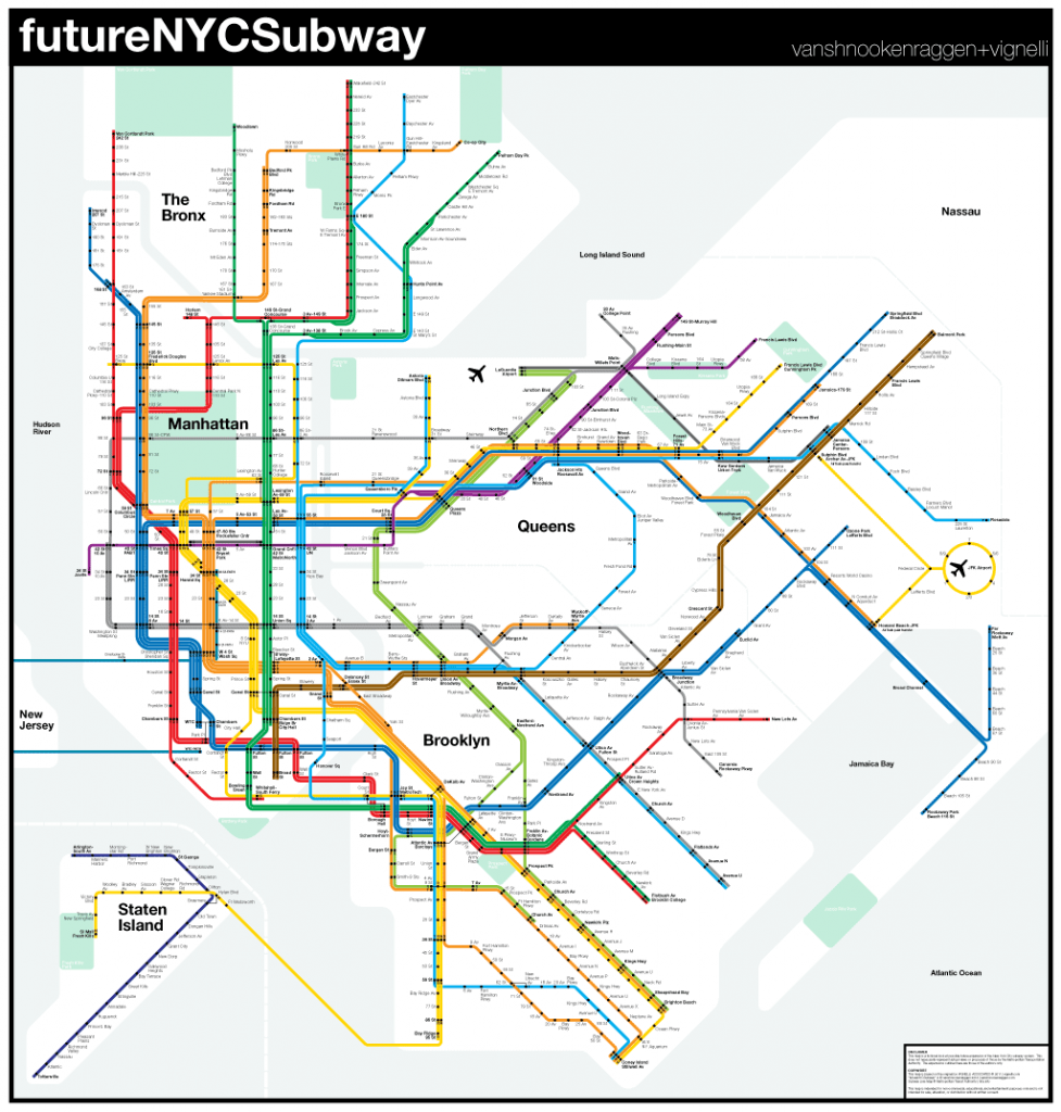
If you ask me, the Lefferts Blvd (A), (E), (F), (J), (Z) and (7) all need to be extended to the Queens/Nassau border. It is just the Lefferts Blvd (A) should extend to Cambria Heights, and the (E) should take a different route to Cambria Heights, above the LIRR Montauk/West Hempstead ROW to St. Albans, then joining the (A) to Cambria Heights.
The (J) is somewhat correct, but I would have it below the LIRR ROW to Hollis, then come above the LIRR ROW to Queens Village and Belmont Park – which is imperative to restructure the Queens Bus Network in Eastern Queens so that LIJ Employees have a direct bus connection to the (J) at Queens Village.
The (F) should terminate at the Cross Island Parkway if it turns on Braddock Avenue.
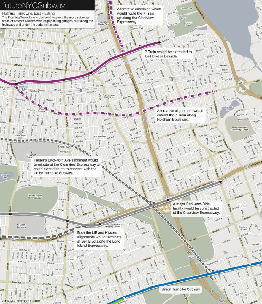
Then I would send the (7) as far East as Little Neck, which would increase service to the Q36 on Little Neck Parkway to a 7 day service.
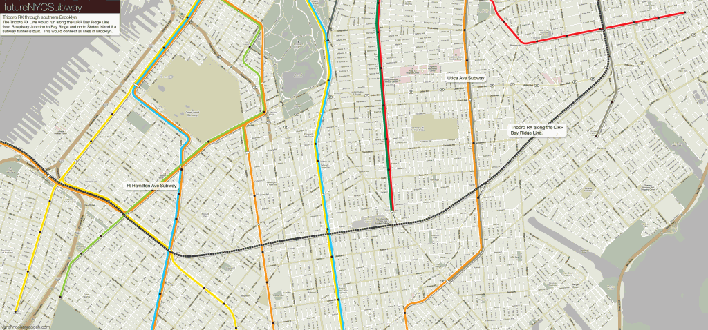
I say scrap the Union Turnpike Subway, as there would be better use as a feed from Triboro RX to the Horace Harding Expressway Subway to Oakland Gardens, which allows customers to feed into the Queens Blvd Local at Woodhaven Blvd.
Then I would build a Bronx to Queens Subway line which would travel Eastern Queens above Springfield Blvd from Southeast Queens (JFK Airport) and alongside the Throgs Neck Bridge and above East Tremont Avenue towards Riverdale.
The (3) train should just extend to JFK Airport above Linden Blvd and Conduit to service Cypress Hills Houses, Pink Houses, Linden Plaza, Lindenwood – Cross Bay Blvd and connect with the Far Rockaway (A) train at Howard Beach.
I would have the (H) line from Rockaway Park to 2nd Avenue via the 6th Avenue line feed into the 63rd Street Tunnel via the Queens Blvd Bypass.
The Utica Avenue Subway is correct, but I would rather it be the (B) line since the 2nd Avenue Subway would travel the Brighton Beach line.
And if you ask me, the (Z) should separate from the (J) at Sutphin/Archer rather than Parsons/Archer. It appears to be a more direct route towards Rosedale than looping round to service York College just to go above the LIRR ROW.
I don’t think the (N) and (W) needs to extend into LaGuardia.
In reality, the (E) should be sent back to Hillside Avenue and have the Cambria Heights branch spur from the Hillside Avenue line with the (E) continuing East towards Queens Village, Floral Park and Lake Success (replacing the Union Tpke Subway). The Cambria Heights line would be an extension of the Queens Blvd Local (either a new (K) line from the (G) Crosstown – see below, or the (V) 6th Avenue Local line). The (F) would replace the (E) at Jamaica Center, and anyone continuing to Southeast Queens would transfer at Sutphin/Archer to the (Z) to Rosedale.
The (7) line should become the (7) and (8) line, no need for the (8) to run along the (6) line and Lexington Avenue line, with the (7) extended East to Bayside and Little Neck, and the (8) to Union Turnpike via Fresh Meadows and South via Bell Blvd.
There would be a Bronx to Queens Subway line travelling parallel to the Throgs Neck Bridge, and above Eastern Queens corridors, Bell Blvd and Springfield Blvd.
The Lefferts Blvd (A) would be extended to Rosedale via Lefferts Blvd, Rockaway Blvd and above the Belt Parkway as a new faster route to Lower Manhattan.
Hey, I have an idea for your next post, how about you talk about the major problems in the subway and what you think is the best way to improve it.
It is best to increase the transfer connections in Midtown Manhattan, Downtown Brooklyn, Long Island City and the South Bronx so that the directness of travel is increased and commute times are shortened.
People want Midtown service in Rosedale, not Lower Manhattan. The (Z) won’t help Midtown commuters at all. You’ll overcrowd the (E) at Jamaica Center.
I have an idea.Extend the T into Brooklynand have it go down the BQE,then follow the Prospect Expy to Ft Hamilton Pkwy and have it follow up to 4 Av-101 St. If Possible you could also extend the R train to link up with the T. You’ll kill 2 birds with 1 stone:A Ft Hamilton Pkwy Branch And a T Train To Brooklyn
If the T goes to Brooklyn, it should be on Fulton, not any other trunk. Extending the G makes the most sense for a Ft Hamilton Pkwy LIne, except it should terminate in Dyker Heights.
The point of connecting 2nd Ave to 4th Ave (Brooklyn) is to save money by postponing Phase 4 while tying it into the existing subway network. AN additional benefit would be allowing the 6th Ave Exp trains to then be rerouted to Williamsburg and take over the BMT Broadway Line. This is something I’ve outlined in the most recent 2nd Ave post. Connecting it to Fulton St is a fantastic idea but would require some version of Phase 4. A connection could still be made between Fulton and Montague Tunnels as a way to route Broadway and Broad St trains along Fulton St. It would be a good half measure until a connection with 2nd Ave is made.
As for the G I don’t really see the need to extend it past Church Ave. The old IND Second System proposal was just another way for the city to syphon riders from the BMT routes and really isn’t needed today. What southern Brooklyn would benefit most from is a redesign of the bus network, especially through Borough Park where there are hardly any lines! A BRT route along Ft Hamilton Parkway would be a first step, though I’m not sure the road is really wide enough given the double parking I see. Regardless, a bus network that acts as a feeder system for the subways would help way more riders than extending the G to Dyker Heights.
I have a question. Why cant there be a train that would replace the 8th Ave Line?Instead of running down 8th Ave,it would run down 10th Ave-Amsterdam Ave.The E would extend from WTC to Kings Plaza via a curve through City Hall,over the Bkyln Bridge and through Cadman Plaza down to Flatbush Ave.The C could also extend from 168 St to Parkchester-E 177 St, via a curve down the Cross Bronx Expy and straight down the expressway.
Another proposal is a line that replaces the 1/2/3 from Times Sq up to 168 St, and the Broadway line. It would be a K train that runs from 242 St to Whitehall St. It would also have a V express train.
This plan is extremely counterproductive. You want to close down lines at extremely high costs? Yeah, you’re gonna have all of 7 Av and 8 Av coming at you with pitchforks(not literally). And the other two plans are highly unnecessary, because the R blocks the first one from happening and there isn’t room for the second proposal considering you would waste money deep boring through hills. Not to mention this will cause a multitude of delays in traffic.
Fair enough.The only I dont understand is this. I’ve seen other ppls. Fantasy maps and almost all include the J, Nassau St M(Brown M),the Z,and another Nassau St Service that all go to the 4 Av Line and branch out with the other lines to Coney Island.WHAT’S THE BIG DEAL WITH BRINGING THE NASSAU LINE DOWN TO BAY RIDGE AND CONEY ISLAND!!!!!
Because the demand is for midtown service. Lower Manhattan has shifted to more residential, mixed use over the decades and the need for Nassau service is there. Just look at how low the R train ridership is, more riders want to go to midtown by a huge margin.
Ohh. Ok.
WestEndExp,I meant 113 years ago(MTA anniversary in 3 days😀😀😀) when the 7th/Lexington Lines were being built, why couldn’t they spend the money on going from South Ferry, up West St to 14 St, then down 10th Ave-Amsterdam Ave all the way to 215 St. And continuing the Broadway Line all the way to South Ferry where Broadway ends.That would’ve been genius in my books.
But on the East Side they should’ve made it so that the 4/5/6 currently run on Park Ave, and the T line runs on 3rd Ave, not 2nd. Honestly that wouldve been smarter. Customers would be within 2 blocks of a train(Lexington Ave would be the exception b/c it would be 1 block away from any train on the East Side).It would be so that4/5/6 customers would walk from 5th and Madison, and T train customers would be at 2nd and 1st. It would be more convenient for East Side customers b/c the subway is closer. And in case we have Hurricane Sandy all over again, flooding would have a less chance because it would be farther away from the East River. The only con is that it’s farther from the NYC Ferry stop at 90 St/34 St. Also the UN wouldn’t be served at the 42 St stop. But those are minor and can be easily replaced by the ppl 0″ major pro of THE METRO-NORTH ELEVATED AREA COULD BE TORN DOWN.More parks/houses people!Less homeless ppl on the trains.Another pro is that it provides easy acsess for the 4/5 to make a sraight shot from 125 St to 138 St. Also 3rd Ave is a major street on the East Side( the others being Park/5th) so a 4 track subway(or provisions for one at least) would have to be built in order to keep up with the crowd.
In conculusion, the people who planned out the beginning of this empire didn’t plan hard enough. Otherwise no one would ver have to complain about the subway.
Minor Suggestion: Extend the 2/5 to the V/O train.I know a lot of people that would benefit having that could connect Downtown Brooklyn with Bed-Stuy/Midtown.
A Few Questions:
1. Why didn’t the engineers working on the subway form it all on 1 level on certain lines, like the Brooklyn IRT,Lex Ave Line north of Grand Central, CPW Line (59 St to 110 St), 63 St-Lex Ave Station,etc. . Like seriously, does it hurt to spend an extra hundred thousand just to make the station on the same level !😠😠I know a lot that would benefit from having to go down one less flight of stairs, just so they can catch their train on time.And in case they want to make extensions, all they have to do is choose which tracks they want to extend and have it dip below the line.
2. WHY DIDN’T THE MTA MAKE THE (G) WITH ISLAND PLATFORMS(Bedford-Nostrand doesn’t count because there’s still one center track that seperates the two island platforms; Court Sq/21-Van Alst
are the only island platform stations on the (G) north of Bergen St where it meets up with the (F) ).Like seriously that’s a extreme pain in the ðŸ‘.
3.Why wasn’t the Flushing Line built with 4 tracks for full time express service, not just weekday rush hours?
Now to anyone that has taken the at any other stop but the terminals, you will know that there’s no way to get a seat. Super speedy( you can get to Manhattan in under a half-hour), but extremely packed in either direction. So why didn’t they think of constructing the line with 4 lines, that way the could run at all times except late nights. Like honestly, the MTA is seriously slacking.
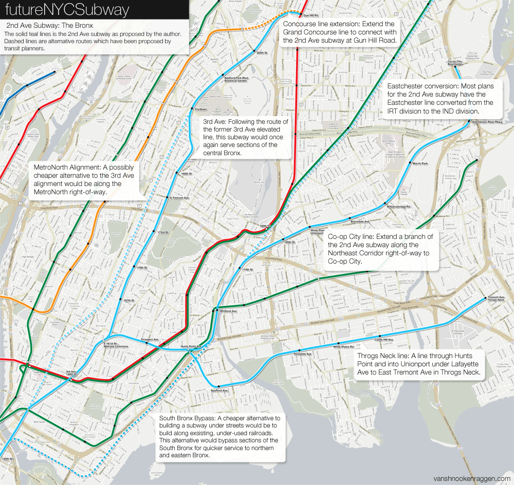
4. Why isnt there a line that runs from The Bronx to Queens,while running through Midtown? Connecting those 2 boroughs would be a major milestone. Now Ibknow some ppl would disagree and say connecting Staten Island to Manhattan would be a major milestone, but Bronx and Queens are 2 of the biggest boroughs, and together houses nearly half of NYC’s pop. .Now connect the 2 with a 1-Seat ride, and you have a major boom in riders that would love to skip through traffic on the Cross-Bronx, Grand Central, CIP, BQE, and LIE. All this while dropping riders in the middle: Midtown.
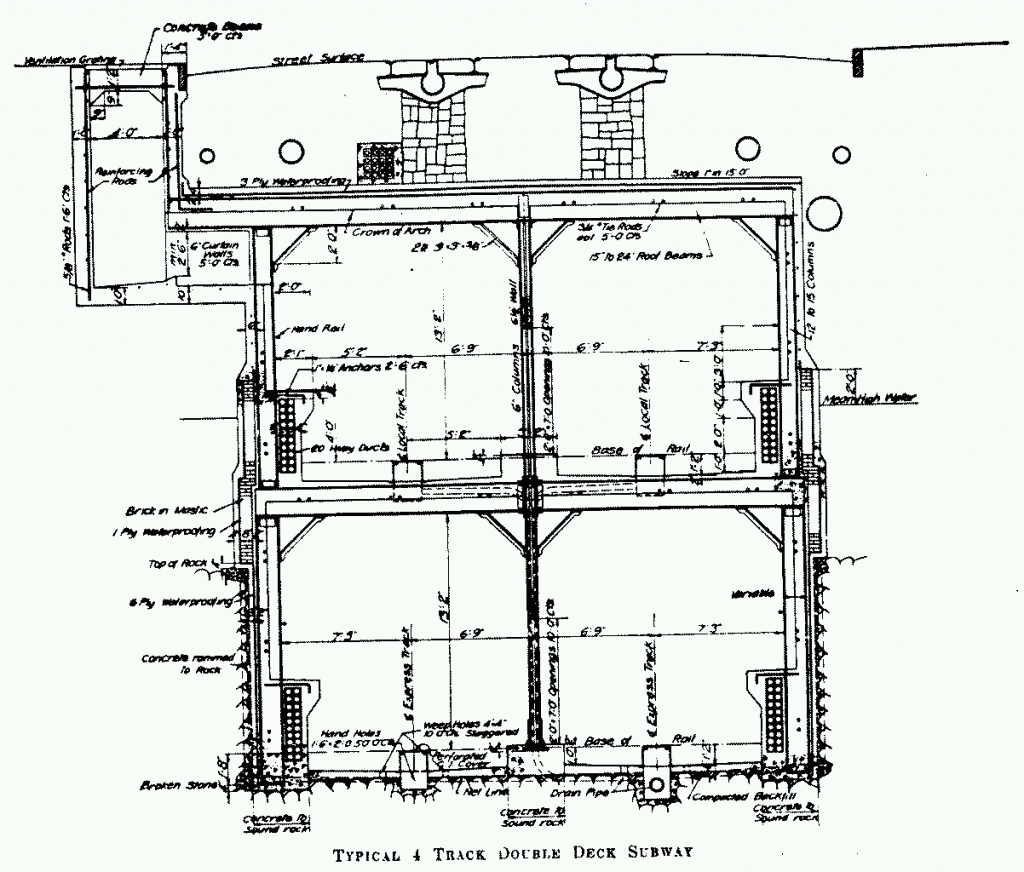
1. The bi level subway was done for a few different reasons. Along Eastern Parkway it was done to save the row of trees along the median which would have needed to be cut down (this was a demand by residents), along Lexington Ave it was because the avenue was not wide enough to avoid making buildings along the route structurally unsound (or rather to save money on what would have been an astronomical cost to reinforce them all, not “an extra hundred thousand”, and finally along CPW it was done because all riders would be coming from the west so it didn’t make sense to have them cross the street or build a large mezzanine (which BTW would have required riders to go down two sets of stairs ANYWAY). The bi-level stations did have an ingenious design which is that the downtown platform is on the lower level while the uptown level is on the top; this means that most riders only ever have to walk up one flight of stairs (most riders, anyway).
2. FANTASTIC question. I really wish there was a diary or something somewhere that explained the design choices for the IND. So much of it is puzzling. It would have made way more sense and probably been cheaper to do it with one platform. My guess is that because they had federal WPA money they built more than they needed to justify the cost?
3. Google a picture of the 7 train when it was first built and you’ll see your answer. Queens was farmland and the extra cost wasn’t worth it. Remember the 7, along with the other elevated lines in the Bronx, was built by private companies who had the bottom line to worry about. The IRT was built with narrower cars to save money because they didn’t know if it would be a success. The extra cost and the low ridership is why there are only 3 tracks. Also consider that NYC is one of the only systems in the world (especially at that time) which even has express tracks. So it’s no wonder they didn’t think about building more of them at the time. Lastly, planners at the time envisioned many more subways stretching across Queens which, if built, would have taken the strain off the 7 train.
4. The simple answer is that until recently there was never a demand for it. Before cars people lived close to their work. If you worked at the Steinway Piano plant then you lived in Astoria. Train commuting is even a novel idea which has only really come about since the rise of the suburbs, which, were mostly for wealthier people who commuted to places like Wall St. So there didn’t really need to be inter-borough train routes. Even when subways were built they were still Manhattan-centric because that’s where the demand is.
Highways broke this pattern so that people could live where they wanted. It also helped developed areas outside of the city center so for the first time people didn’t have to commute to the city. But the downside for transit planning is that the dispersed nature of suburban commuting makes it very hard to build a rail network that can serve drivers. And besides, the 4 train to 59th St is pretty quick and building a new line between the Bronx and Queens is expensive (not that I haven’t proposed it on here a few times 😉
1. Understandable then.
2.I so agree like why isn’t there a book on the IND’s thoughts.
3.Ah ok.
4. I understand,but still I feel that it could do something.
Quick idea I’ve always had: The Flushing Loop.
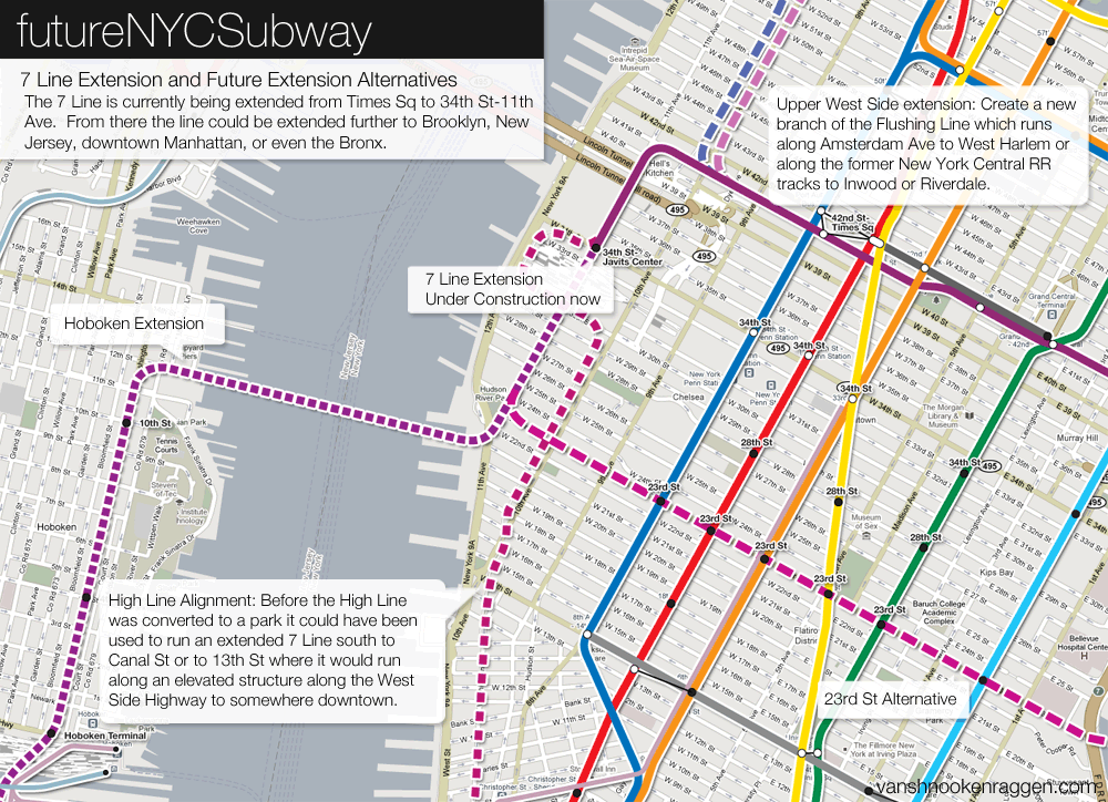
The 7 would still run the same route, but a new line, the 11, would go and run from Flushing-Main St down to Woodside-61 St, and at 52 St, where it curves,the 11 would stay down Roosevelt Ave, which then turns into Greenpoint Ave. It would be known as Queens Blvd Junction. The 11 would stay down Greenpoint Ave up to West St, where a portal would built in the WNYC Transmitter Park to tunnel under the East River to 23 St (Still trying to figure out what angle the curve should be in order to make a safe tunnel up to 23 St). From there it would dive down under all the trains at 23 St (the only of this plan is that any of the stations might collapse under the tunnel),making stops in between trains so they can have a transfer point with two trains(the only train not served would be the F/M train, because they’re close to the 1/2/3 and the N/Q/R/W.At 10th Ave, the train would curve up to 11th Ave, and would run up to link up with the 7 train at 34 St-Hudson Yds. It would be beneficial, because if there was a derailment on eiether end, the other end could serve both the 7 and 11and still meet up with up with the same trains at 42 or 23.
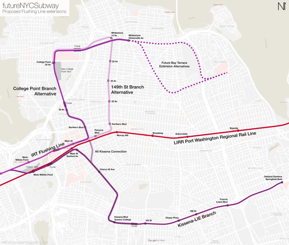
Loops are something that have fallen out of fashion in modern times. They are limited with capacity and are notorious for unbalanced ridership which means you are either over serving one area or under serving another. The 7 is ticky because I’m sure most of the ridership is transferring along 42nd St. So it would make sense to have another branch that would offset the load. The problem is that if you build the loop in the way you’ve designed it would automatically under serve Sunnyside and LIC, splitting the TPH through Greenpoint. LIC is booming right now so any reduction in train service is a non-starter. Branching also requires merging which reduces capacity (not to mention adds delays) and that’s the last thing the 7 needs.
What the 7 really needs is a parallel subway to relieve it. Once ridership drops a bit then you can consider crazier things to do with it. Right now any branching of the 7 could only be in Flushing.
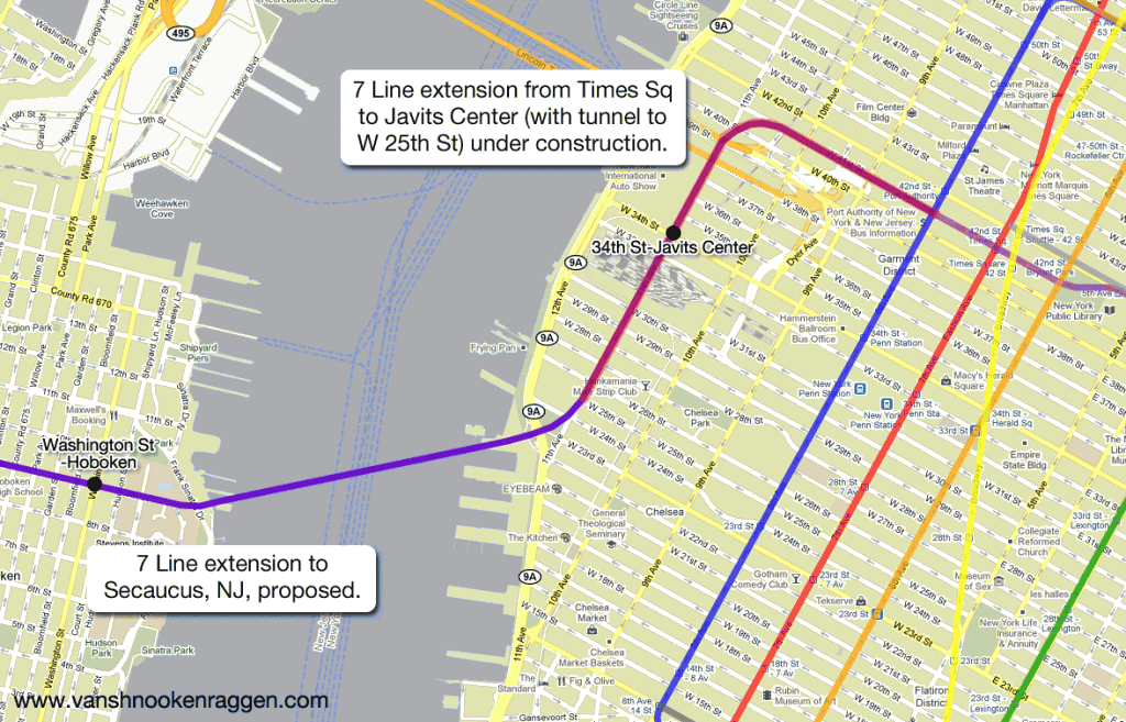
There are those that think the 7 should be extended to NJ but, besides the political and cost hurdles, that seems like a poor planning decision. If you are on an NJT train headed into Penn why would you switch at Secaucus for a slower train? Just go to Penn and take the subway one stop (or walk)!
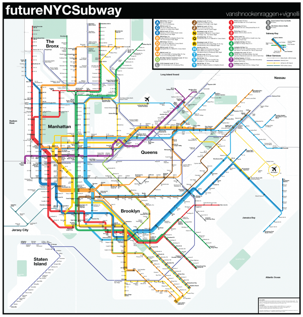
This is my future subway map of NYC- hope you enjoy it.
http://app.enmodal.co/?id=bee7a31886ae8a71
Nothing is showing up.
It works fine for me even when I’m signed out. But how is it not showing up?
If it is private, then I’ll change it to Public.
http://app.enmodal.co/?id=bee7a31886ae8a71
or this?
Yes that works! Do you have a description of what you’re proposing?
This is the description:
(A) 207 St to Far Rockaway (8 Av Exp, Fulton St Exp, Rockaway Lcl)
(B) Gun Hill Rd to Little Neck Pkwy (Concourse Lcl, 6 Av Exp, LIE-Central Queens Exp)
(C) Fort Lee to 234 St-Cross Island Blvd (8 Av Lcl, Jamaica Exp)
(D) Dyre Av to Coney Island-Stillwell Av (Concourse Exp, 6 Av Exp, Brighton Exp)
(E) Laurelton-Springfield Blvd to WTC (8 Av Lcl, Queens Blvd Exp)
(F) Langdale St to Coney Island-Stillwell Av (6 Av Lcl, Queens Blvd Exp, Culver Exp)
(G) Forest Hills-71 Av to Dyker Heights-86 St (Crosstown Lcl, Queens Blvd Lcl, Ft Hamilton Lcl)
(H) Rockaway Park to Church Av (6 Av Lcl, Rockaway Lcl, Culver Lcl)
(J) Hollis-193 St to Broad St (Nassau St Lcl, Jamaica Lcl)
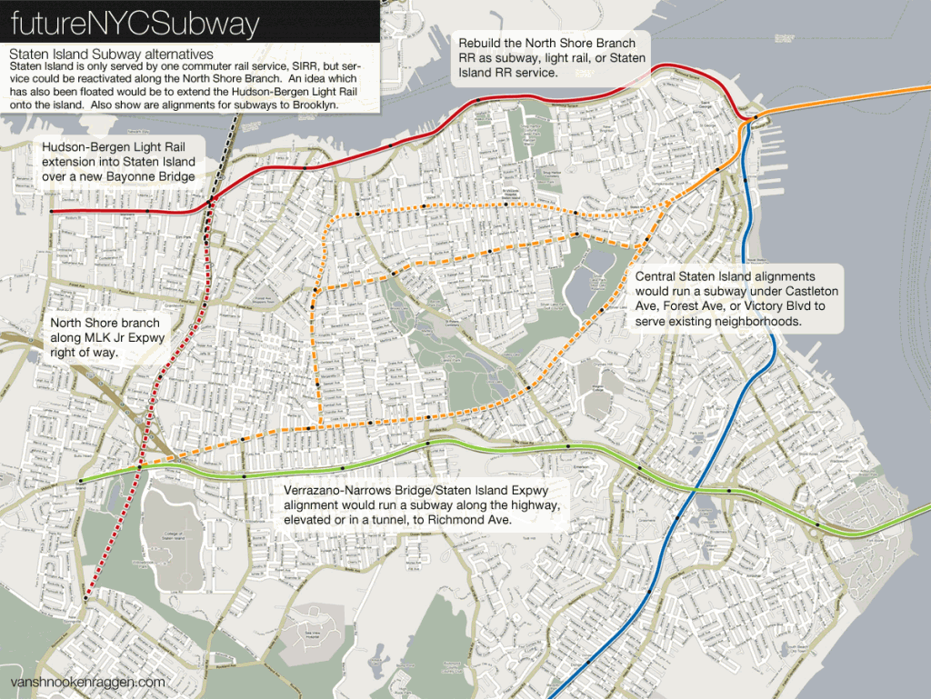
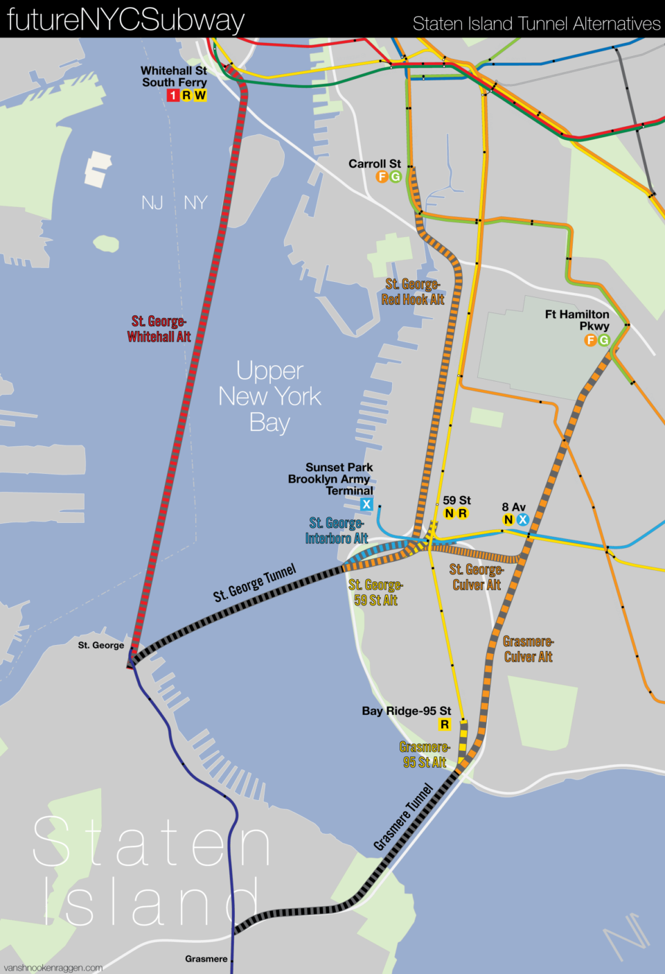
(K) Fort Lee to Victory Blvd (8 Av Exp, Staten Island Exp)
(L) College Point to Rockaway Pkwy (Canarsie Lcl, Northern Blvd Lcl)
(M) College Point to 9 Av (Myrtle Av Lcl, Nassau St Lcl, 4 Av Lcl)
(N) Forest Hills-71 Av to Coney Island (Broadway Exp, Queens Blvd Lcl, 4 Av Exp)
(P) Throgs Neck to Jamaica Av (2 Av Exp, Throgs Neck Lcl, Union Tpke Exp)
(Q) Broadway-125 St to Coney Island (Broadway Exp, Brighton Lcl)
(R) Bayside-Bell Blvd to Bay Ridge-95 St (Broadway Lcl, Astoria Exp, 4 Av Lcl)
(S) Grand Central to Times Square (42 St Local)
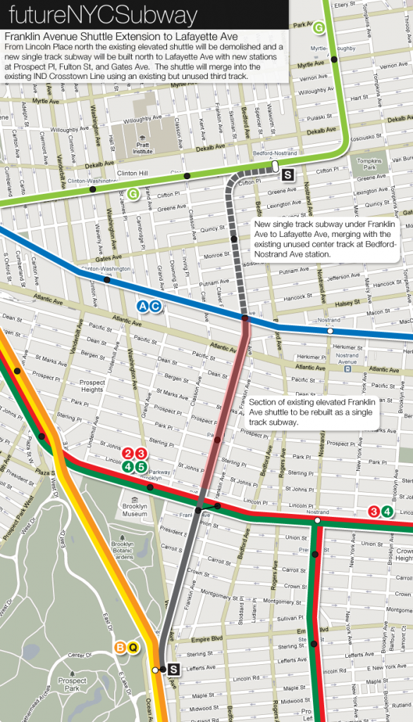
(S) Bedford-Nostrand to Prospect Park (Franklin Av Lcl)
(T) Gun Hill Rd to Lefferts Blvd (3 Av Lcl, 2 Av Lcl, Fulton St Exp)
(V) Jamaica-179 St to Coney Island (Queens Bypass, 2 Av Exp, West End Lcl)
(W) Flushing-Main St to Euclid Av (Broadway Lcl, Astoria Lcl, Fulton St Lcl)
(X) 168 St to St. George Terminal (Triboro Lcl)
Hope you enjoy!
Ah.Fair Enough.
WestEndExp, I saw your map. A little complicated,but great boost in pop. Like damn you got over 100,000 riders at 86 St, and an actual population in Staten Island. Nice work😀😀!
Why is it that when I see others fantasy maps they all always have the L and 4 meeting up at Kings Plaza?
few reasons why it’s stupidity: the L is already above ground at Rockaway Pkwy. So you’ll have to destroy everything south of New Lots, including a vital area:Canarsie Yds.Also it has to make a extremy tight curve at Rockaway Pkwy, which is dangerous. And another tight curve by the Belt Pkwy and Flatbush Ave. Now with the 4 you’ll have to build a curve like the Q at 63 St, then dig up Utica, make a sharp curve at Flatbush to get to Kings Plaza. Then there’s the problemof making the transfer between an above-ground station and a underground station(not hard, but costs a lot of money.).And let’s not forget that this terminal is being built at a shopping mall’s bus station, which disrupts bus service.You may have your own opinions, but this is mine.
Good points. Also consider that Kings Plaza would never need that much service. The 4 would be enough. The 4 would be express to downtown Brooklyn and Manhattan while the L would be a slow local through East NY, Bushwick and Williamsburg. There is far more demand to downtown Brooklyn and Manhattan than those other areas so the L would be a complete waste.
So I’ve tinkering with the website that WestEnd was using, and I’ve created 2 subway lines that serve both important streets:
-A line that would go Kings Plaza, curve up Utica,stay on Utica-Malcolm X up to Broadway,curve up Broadway to Williamsburg Bridge, then run down Delancy St to Essex St, and refigure the Chyristie St Connection so it would link up with Broadway, then go down Broadway to 225 St in The Bronx. It would have 3 lines that branch out, the first would stay down Broadway in Brooklyn to Bdwy Junction. The other 2 would curve out from 122 St in Manhattan to link up with 125 St, then stay down 125 St to Randalls Island, where a 3-way switch would be built, 1 going to The Bronx, another going to Queens, and the last connecting the 2. It’s basically the Hammels Wye.The route that goes out to the Bronx would travel down 149 St, then curve down to Southern Blvd where it would stay on it up to the Botanical Garden.The Queens route would use the Hell Gate Bridge, but curve off beforge it hits Queens to run down Dimtars Blvd. A portal would be built in the park that lies right before the actual streets. It would run down Dimtars Blvd, curve on Hazen St and run under LGA(obviously making stops there), goe through College Pt. Creek, and runs down College Pt. Blvd to 14 Av, curves down to either Parsons Blvd or Francis Lewis Blvd, and from there it would run down to Main St, where it would curve down and run back to College Pt. Blvd (it makes a 360* around College Pt Blvd. The other runs down 4th Ave to Barclays Center, curve up Flatbush to the Manhattan Bridge, then link up with the 1st until 14 St, where
It would run Park Ave until Fordham Plaza in The Bronx.
Correction: The 4th Ave Line would link up with Hamilton Ave, make stops in Red Hook via Hamilton Ave, then run under the Hugh.L.Carey Tunnel, then curve off to stop at Governers Island, then run down to Broadway in Manhattan until it meets up with the 1st line, then would continue under Broadway until Union Sq, where the 2 lines would split and the 4th Ave Line would run under Park Ave until Fordham Plaza, where it would curve under Webster Ave until Gun Hill Rd, where it would run down Gun Hill Rd until Bay Plaza, where it would link up with the 6 at Pelham Bay Pk.
A few more questions:
1. What’s up with the 125 St confusion on the 4/5/6? Like seriously! If the 6 is already on the same platform at 116 (built before 125/Bronx connection, please note), then why don’t they stay like that at 125 St, and have the 4/5 on the lower level. That way when trains are terminating at 125 St or running in two directions and terminating at 125 St, then you can just cross the platform to get the other train instead of making passangers walk a flight of stairs to get to the other train. And if you look carefully, the tracks are on opposite sides on each platform on both levels.
2. Why did they stop sending the B to 168 St, and the C to Bedford Park Blvd? Now having the 6th and 8th Ave Lines pair up together was a great idea. Passengers would be able to get to Coney Island or East N.Y. just from Grand Concourse, and Rockaway Park or Coney Island from Washington Heights.
3. Can the A,B&D really get the title of ‘express’? Now the A and D don’t stop from 59 to 125, so that is technically a super-express, but the only stops it skips (on the A) 50,23 and Spring, which isn’t much because the C and E could get there only a few seconds later, so it’s pointless to call it express. And on the D it only skips 23 and 14th, and the F/M would still probably make it to either W 4th or 34th in the same time.
4. WHY DID THE 9 EVER EXIST?! When the 9 was around it pretty much screwed the 1 train by making skip-stop service. So if you needed to get to 157 St, and you were on the 9, you needed to transfer at the nearest stop where the 1 and 9 met up and take 1 back down. NOW IMAGINING DOING THAT AS YOUR DAILY COMMUTE.
My answers to Tyler’s question:
1. Fantastic question. I don’t know why they made the layout that way. It would be more simpler to just keep the (4)(5)(6) on separate levels, then have the lower level tracks ascend and then all tracks are at the same level.
2. They were swapped because of yard reasons. The (B) was based out of Concourse and the (C) 207, so it wouldn’t really make sense to make it complicated to go between yards.
3. They’re still called expresses to avoid confusion with locals. And this goes for other lines too.
4. The (9) existed for skip-stop in order to speed up commutes on the northern half of the 7 Av line. And if you were going to 157, you would simply wait for the (1). This was discontinued in 2005 because of increasing ridership at the stations the (9) bypassed.