
This post was written with the Tech Transit Association, a youth run transit organization/club at Brooklyn Technical High School, and with the help of Transit Talk NYC. The organization advocates for better transit in NYC and beyond. The organization’s current project is the 7 train project, and it advocates for better service for commuters who use the 7 train. The TTA is Edward Zheng, Gabriel Villanueva, Yusuf Badar, Alex Kim, and Alexei Sanoff. Follow them on Instagram, Twitter and YouTube.
Introduction
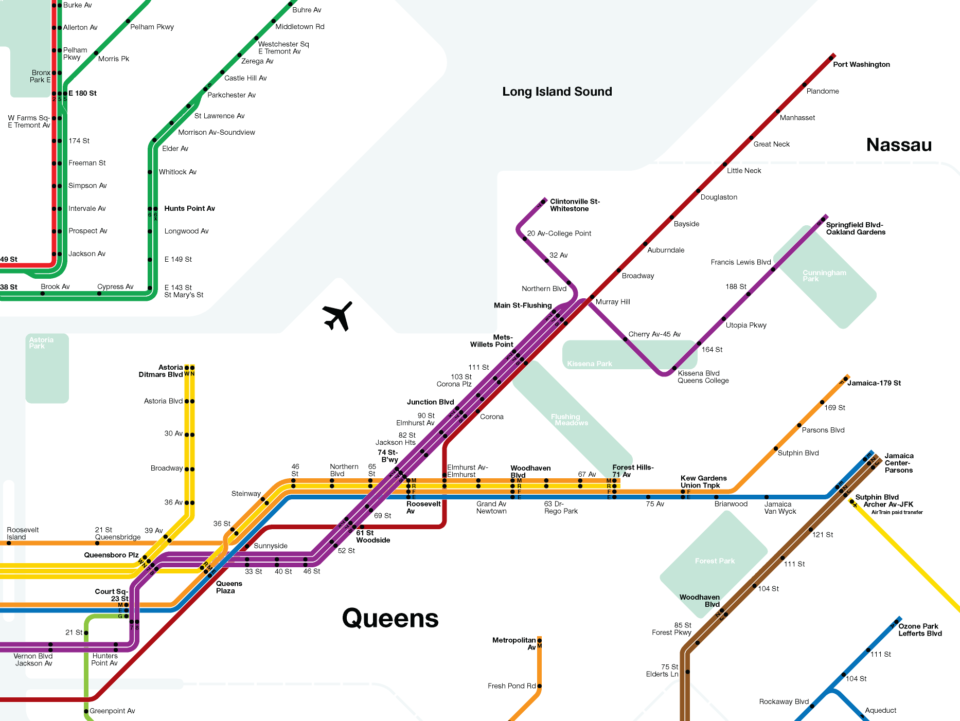
The 7 train runs between 34th St-Hudson Yards and Main St in downtown Flushing. Main St acts as a major transfer hub between the subway and local bus lines. The existing bus network is designed with a mix of feeder lines to Main St and through lines between Flushing, Jamaica, and Long Island City. Running through downtown Flushing is the LIRR Port Washington Line, connecting Penn Station to Port Washington in Nassau Co.
The 7 train is one of the most heavily used subway lines in the NYC subway network. Even with modern CBTC signals, the line often runs at capacity. Because of outdated operations, the two other modes of travel, LIRR and bus, do not, and can not, properly relieve the 7 train of its crowds.

A large section of Flushing is classified as a transit desert. Since the last extension of the subway system into Flushing was built a century ago, much this quadrant of New York has developed into the typical post-war auto-centric suburb. Flushing has relatively good highway access via the Long Island Expy, Whitestone Expy, Clearview Expy, Cross Island Pkwy, Throgs Neck Bridge, and Whitestone Bridge.
As we enter a world of warming temperatures, the number one thing we can do to reduce global warming is to change our land use and transportation policy to create more sustainable neighborhoods. Rail lines are great at creating dense, walkable neighborhoods. But expanding our current network is hampered by existing bottlenecks, existing capacity issues, and a lack of will on the part of the city to utilize transit expansion to facilitate development.
Over the past two decades, all major transit projects in New York City have focused on Manhattan; The 7 train extension to Hudson Yards, the 2nd Ave Subway, East Side Access, the Fulton St Transit Center, and Moynihan Station have all been big ticket projects that only focus on riders experience within the city center. While these projects have merit, they have left residents of the outer boroughs with the same levels of service they’ve had for generations.
Summary

The original aim of this report was to explain how the 7 train could be expanded deeper into Flushing. But given the existing capacity constraints on the line, we must first look at ways to decongest the 7 train so that it will be able to handle the existing ridership which will be attracted by such an extension.
Transportation advocates have focused on fixing New York’s outdated bus network. Many bus lines run on routes of former streetcars and have not been updated to reflect current needs. Currently, the MTA is looking at redesigning the bus network within Queens. A smart design element of the working plan is to create better crosstown bus lines which connect neighborhoods with subway lines. While this can lighten the burden at some subway stations by spreading the load, since the 7 train is the only subway line running to Flushing, all bus lines will still end up dropping riders off at the train.
- The first recommendation is for enhancing both radial and crosstown bus lines, running parallel or perpendicular to the 7 train, with bus lanes. A bus lane along Northern Blvd from Queens Plaza to Douglaston is the logical first step. This will reduce the need for riders to transfer to the 7 train on their way to LIC and Manhattan, providing a faster alternative to local trips. Bus lanes on crosstown lines are needed as well, but these will primarily serve riders going to the subway and have less of an impact on reducing congestion on the 7 train.
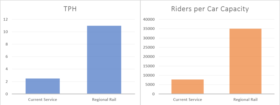
- The second recommendation is to convert the LIRR Port Washington Line into a pilot Regional Rail line. With enhancements, the new Port Washington Regional Rail Line would serve 35,000 riders per hour, half of what the 7 train handles. This can be achieved by:
- Pairing the fares to the subway and buses.
- Providing free transfers to the subway and bus network.
- Increasing service from 6-7tph split between local and express trains to 10-12tph with a single, local train running the entire way.
- New rail cars which would have more standing room and more doors to facilitate higher riders per car.
- Stations that are equipped with fare gates. Platform 10 at Penn Station would be segregated for the Port Washington Line with fare gates.
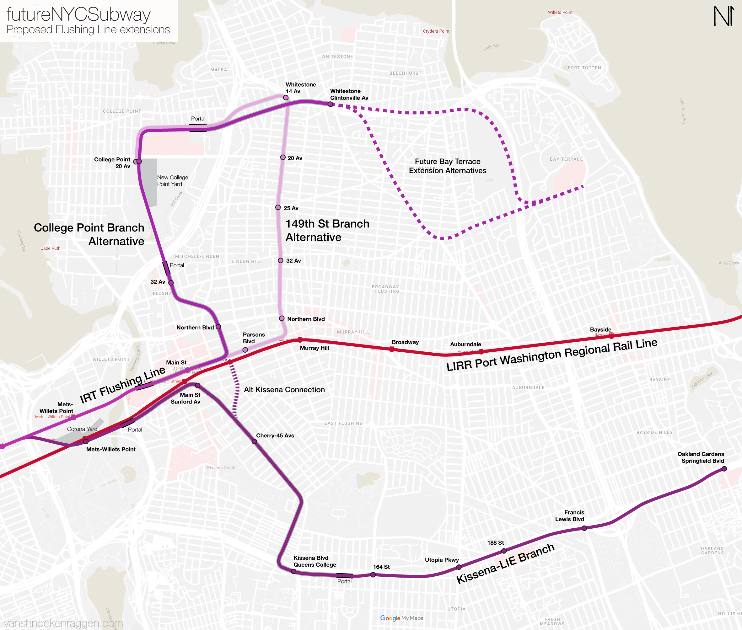
- The final recommendation is for extending the 7 train north and southeast. Two branches (one to be an extension of the 7 train and another to be a new 8 train) would radiate from downtown Flushing.
- A branch off the existing subway between 111th St and Mets-Willets Point stations, heading southeast along Kissena Blvd to the Long Island Expressway. It would run along the expressway on an elevated viaduct out to Springfield Blvd. This branch could attract up to 50,000 daily riders. Travel time from Main St to Springfield Blvd would be 20 min.
- A branch to the north to College Point and then east to Whitestone. This branch could attract up to 38,000 daily riders. Travel time from Whitestone to Main St would be 16 min.
Both of these extensions would attract existing ridership and create opportunities for development along their routes which would use value capture to help pay for the extensions.
There will be no silver bullet which will solve transit issues in northern Queens. Queens simply needs more trains. But in order to know what to spend the big bucks on, we must use what we have most effectively first. Improving bus speeds can help riders today. A regional rail pilot on the Port Washington Line would be very affordable to implement and act as a test bed for the LIRR to experiment with regional rail before expanding it to other lines. Providing free transfers to the LIRR, rather than just the subway, would take pressure off of the 7 train. The 7 train can then be extended into the neighborhoods not already covered, setting the stage for a less car-dependent Flushing.
Background
Like so many post World War II suburbs, much of Queens was developed around the automobile. Trains are focused only on getting commuters into Manhattan even though the majority of residents work within the borough. Many of the bus lines mirror former streetcar lines that were first built over a century ago. For transportation deserts, owning a car is a requirement. Without new transit lines stretching deeper into the borough, all development will be focused on the car. Therefore, it is imperative that for us to lay the groundwork for a more sustainable future we must begin the process of extending transit into these unserved areas of the city.
An eastward 7 train extension dates back to the 1910s when Queens residents were debating about possible routes into Flushing and Bayside. The 7 train had been built as an elevated line as far as Corona (and was called the Corona Line before it was extended further.) Due to massive opposition from Flushing residents about an elevated line, the Main Street station was constructed underground and was finished in 1928.
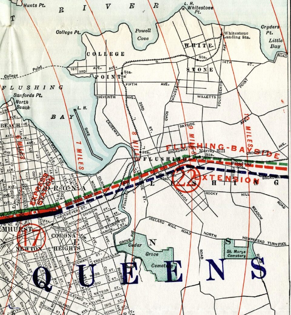
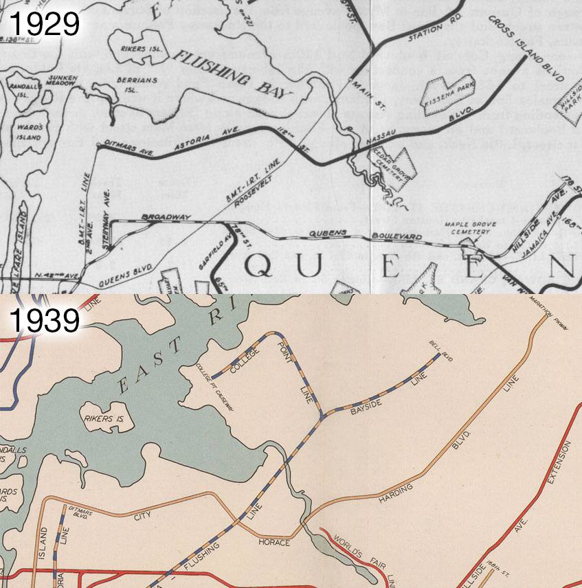
Under the 1929 IND Second System, the 7 train (now the Flushing Line) would be extended to cover a large portion of Northeastern Queens. Initial plans called for the subway to be extended east along Roosevelt Ave to Northern Blvd, after which the line would come above ground and run alongside the LIRR Port Washington Branch to 221st St. A branch was proposed along 149th St to Whitestone, which would then turn west along 11th Ave to College Point.
Due to the Great Depression, the extensions never went past the drawing boards. The Flushing Line extension came up again in 1939, but World War II placed a hold on all subway construction in NYC. After World War II, funds were diverted away from building new subway lines and into maintenance and new highways. The Flushing Line extension was dropped by the 1950s, however a secondary plan was proposed which involved converting the LIRR Port Washington and Rockaway Branches into branches of the 2nd Ave Subway via a new East River tunnel. While a tunnel along 63rd St would eventually be built, any branch through Flushing was disposed of long before.
By the 1970s, deferred maintenance had taken its toll and the 7 train was one of the many areas that needed extensive rehabilitation. Its elevated structure at Queens Blvd and Roosevelt Ave was named “code red.” As a result, the MTA undertook a decade of rehabilitation on the line, strengthening the structure. While this work kept the 7 train running, by the 2010s, stations along the Flushing Line had deteriorated again. Presently, the 52nd, 61st, 69th, 82nd, 90th, 103rd, and 111th Sts stations are on track to receive reconstruction. While there was a brief period of time in the 1960s and 70s where planners were focused on expanding the system, ever since the policies of the NYC Subway have shifted to patching the system.
While no one can deny that maintaining the system is needed, we are entering into a climate crisis. Auto-centric land use policy in the United States and elsewhere has driven up the levels of C02 and other harmful pollutants in our atmosphere, causing rising temperatures globally. Public transit usage needs to double to meet our climate goals, as trains can carry 1800-2400 people, at intervals of two minutes or less at CBTC standards.
The last new subway line in Queens opened in 1989 (63rd St Tunnel), and the majority of lines date back to the first part of the last century. The highway projects of Robert Moses left transit projects collecting dust and leaving our roads and existing rails overburdened. To add to the growing list of problems, Queens experienced a massive population growth, with new Hispanic and Asian immigrants resettling in Jackson Heights, Corona, Flushing, Linden Hill, Whitestone, and College Point. The 2020 Census proved this, as Queens grew by 7.8 percent, and 2.4 million people now live in Queens.
One of the biggest areas for population growth, downtown Flushing, has grown into a dense transit hub and the only station that serves Flushing, Main Street, serves more riders than larger transit complexes in Manhattan. This means that a huge amount of riders crowds a station that was never designed to handle such levels of passengers, nor are the tracks set up to be a terminal station. A number of trains drop out or begin at the 111th St station.
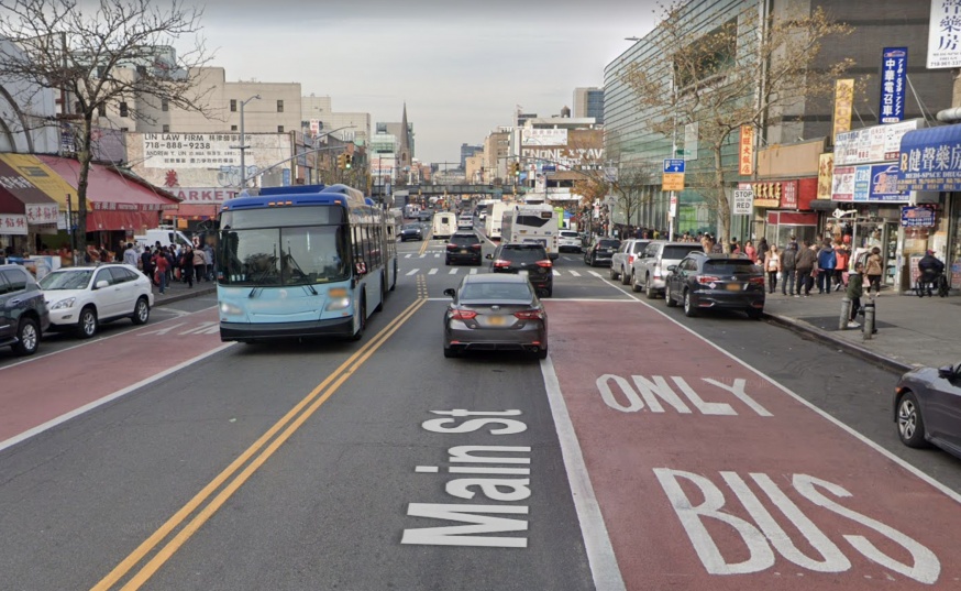
The large number of buses serving the station and the surrounding neighborhoods crowd into the narrow streets throughout downtown Flushing. The multitude of bus lines means that there are three main areas where commuters can catch the bus. One might exit to Lipmann Plaza to catch a bus to Whitestone, or another will exit to Main Street to catch a bus to Bayside. The Flushing bus hub is complex, yet it is extremely congested. That is why the MTA and the DOT have rolled out the Main Street busway [PDF] to give dedicated right of way to buses.
However, those efforts are inadequate, as it is limited to only a small portion of Main Street and Kissena Blvd. There are multiple other streets in Flushing serving multiple bus lines (Northern Blvd, Kissena Blvd, Roosevelt Ave to name a few), yet they do not have a busway status. As more people move into Queens the surrounding streets will continue to be congested.
To its credit, the MTA is aware of the shortcomings of the current bus network. In 2019, the MTA released a preliminary bus redesign which aimed to reimagine how buses function from the ground up. While it faced almost universal rebuke, mostly due to the sheer scale of the changes, concerning Main St Flushing, not much was new. While some lines were simplified to create a grid of bus coverage, most bus lines would have still terminated, or at least run through, the core of downtown Flushing at Main St and Roosevelt Ave. Therefore, the congestion issues would not have really changed.
The fundamental issue with downtown Flushing is that it functions as both a major destination and also the transfer point for mass transit riders. Considering that this downtown is growing, the only function that we can change is how riders arrive and pass through Main St. This proposal will look at three options which would help to “spread the load” so to speak. Flushing has its own center of economic gravity which means that not all riders are coming to Main St simply to transfer to a train into Manhattan. Different modes of transport will need to be considered to understand what will best serve this quadrant of the city.
Proposals
Select and Expanded Bus Service
Expanding bus-only lanes with select bus service will be the cheapest option and would require minimal construction. Northeastern Queens has a complex network of feeder bus lines and through-lines which connect multiple downtowns. In looking at how to fix the bus network we must understand the corridors which need the most attention.
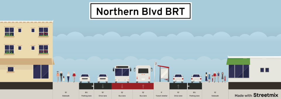
Northern Blvd, running from the Queensborough Bridge in Long Island City through Flushing to the border with Nassau County, is the seemingly obvious first choice for Bus Rapid Transit (BRT). The road is 100’ wide, including sidewalks. This would allow for two dedicated center running bus lanes with offset platforms, two all-purpose travel lanes, and parking lanes. New ticket machines would be built at the stops so that riders can pay before boarding.
Northern Blvd serves a number of bus routes: the Q66 serves the corridor from Long Island City to Flushing Main St. In 2019 the Q66 saw 4.3 million riders. The Q12, Q13 and Q28 buses serve the corridor from Flushing Main St east to Bayside and Whitestone and collectively saw 8.1 million riders in 2019. Northern Blvd also serves express buses heading east from Midtown. These include the QM2/32, QM3 and QM20 and collectively saw a ridership of 685,447 riders in 2019. [Source: MTA Bus Ridership]
Improving bus service on Northern Blvd is a worthy first step, but it’s only part of the story. While the Q66 sees a respectable annual ridership of 4.3 million, the five crosstown routes which run north-south between 73rd St and 103rd St in Jackson Heights (Q23, 5.3 mil; Q33 2.3 mil; Q47, 2.5 mil; Q49, 2.6 mil, Q72, 2 mil) collectively have ridership of 14.7 million.
The 7 train, which runs about a half mile south of Northern Blvd saw an annual ridership, in Queens alone, of 101.3 million in 2019. The LIRR Port Washington Branch, which runs about a mile south of Northern Blvd west of Main St but only a few blocks away east of Main St, saw an annual ridership of 14.2 million in 2018.
Map showing bus and rail ridership by line width.
Making existing bus lines faster certainly helps. But most riders aren’t taking a bus straight down Northern Blvd to Long Island City. Rather, they are taking crosstown buses to the nearest subway station. This means that while BRT on Northern Blvd would certainly save riders time, it would be more beneficial to the overall bus network to design a series of radial bus-only lanes connecting crosstown buses to the nearest train station (subway or LIRR).
BRT does not save significant time of a distance less than 5 miles. Therefore, time savings for riders coming from east of downtown Flushing will be minimal: Murray Hill (1 mile away), College Point (1.6 miles away), Whitestone (2.2 miles away), Auburndale (2.4 miles away), and Bayside (3.5 miles away). This means that, at best, BRT along Northern Blvd would save time for a fraction of the riders who would normally be taking the 7 local within Queens.
BRT has low capacity; Articulated buses can hold around 150 people and even if you run them every 3 minutes, that is only 3,000 people per hour. If we run that frequency during rush hour, that is nowhere near enough to serve the 155,000 people who travel into/out of Flushing by bus.
Map showing potential BRT corridors. Red: Trunk, Blue: Radial, Green: Crosstown. Each corridor does not necessarily represent a full bus route but rather a general corridor.
None of this is to say that implementing BRT along the corridor is a bad idea. Given the ridership that exists, improving bus service would still help millions of riders a year. BRT can be installed relatively quickly and affordably. A minute saved is still a minute saved. But we must understand that this is only a first step and that, ultimately, we need to address the ridership which is using the bus network as a feeder system to access Manhattan.
LIRR Port Washington Regional Rail
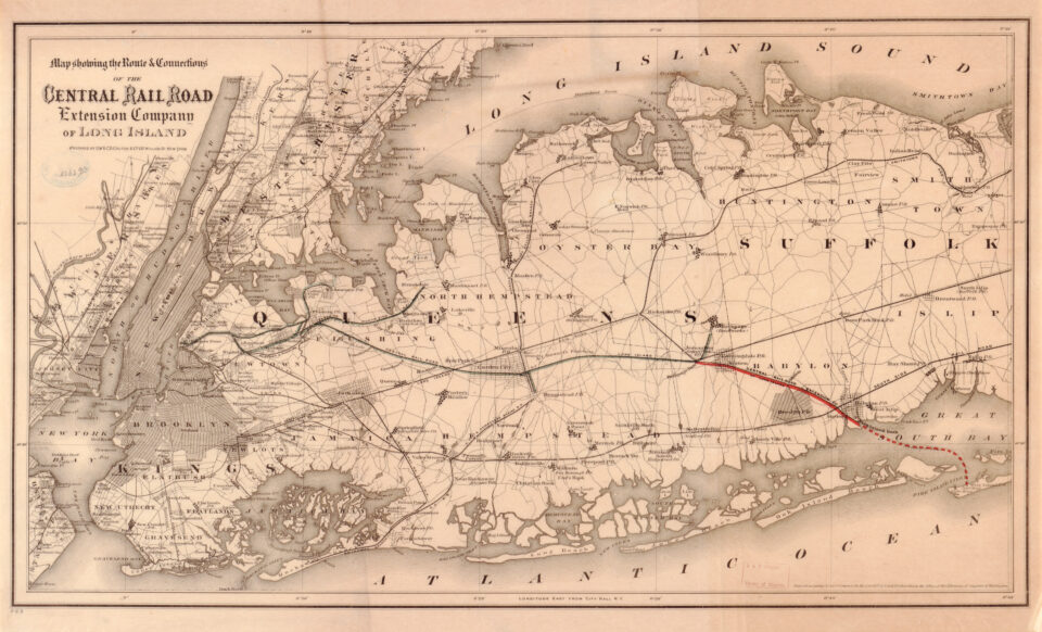
Jackson Heights and Flushing once hosted a number of steam railroads running from Long Island City east into Long Island. These were all consumed by the powerful LIRR and today this quadrant of the city is served only by the Port Washington Line (PWL). There was once a second branch off the Port Washington which served College Point and Whitestone. This single-track line saw infrequent service and was abandoned in the 1920s. Some called for the line to be upgraded and converted into a subway line, but the city didn’t see the potential given the costs of upgrading it.
The PWL runs directly parallel to Northern Blvd, although varies in distance away. Through Sunnyside the two are only about 1,000’ apart. In Woodside, they are the furthest apart at over a mile away. At Main St they are about a third of a mile apart, after which they cross paths at 162nd St and continue a few blocks apart all the way out to Manhasset in Nassau Co.
The line serves the Northern Boulevard corridor rather well in theory, but is handicap by interlining with the LIRR mainline. While there are a total of six LIRR tracks through Harold Interlocking, only four reach Penn Station. East Side Access (ESA) will provide two additional tracks into Manhattan (serving Midtown East at Grand Central) and service, currently about 6-7 trains per hour (tph), is expected to be increased on the line, though no firm number has been given. Even if service was expanded to 10tph it would be a welcome help to the 7 train.
Standard LIRR train cars are designed with more seating and fewer doors than subway cars. Because of this, rider capacity is much lower on the larger, 12-car long LIRR trains than the standard NYC Subway train. M9 trains can hold about 1,300 riders per 12-car train. But R188 cars on an 11-car 7 trains can hold over 2,000 riders. That means that with current levels of service, the PWL can move 7,800 riders per hour while the 7 train can move over 60,000 riders per hour.
The branch, for most of the line, runs separate from the LIRR Main Line. Today, service is run as typical commuter rail for 9-5 workers going to Manhattan. Frequencies are low and service is split between “local” trains which serve all stations between Penn Station and Great Neck, and “express” which bypasses these stations to save time for riders going past Great Neck. Off-peak fares between Penn Station and Main St are $7.75, while peak fares are $10.75. With this type of service and fare structure, the PWL is not an attractive option for switching 7 train riders.
Regional Rail
The PWL is uniquely suited for conversion into a Regional Rail line. Regional Rail is different from commuter rail in that it acts like a subway: it has a more standardized fare structure, operates at higher frequency throughout the day, and trains have more standing room. Ticket takers on the trains would be removed and stations would feature fare gates, just like subway lines. New train cars would need to be ordered which would run with standard LIRR dimensions and power sources, but feature more standing room and additional doors.
When ESA opens, there will be capacity for an additional 24tph at Grand Central. Most of this will be from Main Line branches so they can provide service to Midtown East. While Penn Station will see service shift to GCT, it will also be getting new service to the Bronx from the Penn Access project. Metro North is planning on running typical commuter rail service on the line, so rush hour will see something like 4-8tph. This still leaves space at Penn Station for increased service on other lines.
If the PWL can increase frequency from 6-7tph to 10-12tph then, with larger capacity train cars, the line could handle up to 35,000 riders per hour. Analyzing the work inflow-outflow of Murray Hill, Broadway, Auburndale and Bayside stations, the new service could attract up to 40,000 daily riders from just those stations. Service would no longer be split between local and express but instead run as standard “all stops”.
Current run-times from Penn Station to Port Washington are about 45 min one way. The express service shortens this to 36 min one way. But that’s with service every 20 min. With service every 5-6 min, the total travel time of the express (56 min) is beaten by the more frequent, but longer, local trip (50 min).
The LIRR has been experimenting with the City Ticket along the Atlantic Branch from Atlantic Terminal to stations in Jamaica. Typical off-peak fares are $7.75 and $10.75 at peak times; City Ticket reduces this to $5. The service is very popular, especially as it serves a number of lower income and poorly served neighborhoods of the city. In order to realize the most potential for a Regional Rail line, and be an attractive alternative to the 7 train, the fare on the PWL (at least between Penn Station and Bell Blvd) needs to be the same as a subway ride and free transfers offered between buses, the subway, the Port Washington Line. Stations in Nassau Co. can cost more, but should still be reduced.
In order for this to work, stations would need to have fare gates installed. Using the new OMNY system these gates can be programmed for exit fares further out which will automatically calculate the added fare. All but two current stations serve Port Washington trains only. At Woodside, the Port Washington Branch has a separate, but connected, platform next to the LIRR Main Line. Here a fence can be erected separating the Main Line commuter fare from the PWL Regional Rail fare.
While service to both Penn Station and Midtown East will be possible once ESA opens, it’s recommended that the PWL Regional Rail serve only Penn Station. Having two terminals in Manhattan will create imbalances of service in Queens (i.e. bunching). It will also be much harder to have a separate fare zone at the new ESA platforms under Grand Central without hurting capacity at the terminal. Penn Station features many tracks and platforms, and it will be much easier to take one for Regional Rail while not impacting the overall performance of the station.
Platform 10, with tracks 18 and 19, is unique at Penn Station as it’s considerably wider than the other platforms. This platform was the original terminal for all commuter rail from Long Island. 100 years ago Long Island was far less developed and Penn Station was mostly used for long distance trains. This single platform can be separated with fare gates while LIRR and Amtrak service continues around it.
What is ultimately needed is the ability to freely transfer to the subway or from a bus to the LIRR. This type of integration would have the most impact at siphoning riders away from the 7 train.
Additionally, the city and state should look into adding two infill stations along the line. There once were stations in Elmhurst and Corona, but these were abandoned in 1985. Rebuilding the Elmhurst station was suggested by former Queens representative Joe Crowley in 2012, but even though the MTA added the project to their 2015-2019 Capital Plan, nothing has come of the idea. Adding these infill stations would add a few minutes to the overall run time of the trains, but would save considerable amounts of time for riders converted from buses and the 7 train.
Map of proposed enhancements to the LIRR Port Washington Line to convert it to regional rail service.
In total, a Port Washington Regional Rail line would end up costing, at most, a few hundred million dollars; fare gates and new train sets are within the budget of the LIRR, infill stations would cost more. The added service would equate to that of a brand-new subway line, saving tens of billions of dollars. The PWL will be a test bed for the LIRR to experiment with regional rail operations and technologies so that one day the concept can be ported over to other branches. This new regional rail line would have 50% of the capacity of the 7 train and reduce ridership and crowding to the extent that an extension of the 7 deeper into Queens would not put undue strain on the line.
7 train Extension
Flushing-Main St is the last stop on the 7 train, but this was not supposed to be the end of the line. When the IRT Corona Line was extended into downtown Flushing, it was only supposed to be a first phase of a larger expansion eastwards. The initial plan was to continue the tunnel under Roosevelt Ave until it reached Northern Blvd. After which it would come above ground and run alongside of the LIRR Port Washington Line.
Sometime in the 1920s a branch was added to this plan which would have turned north at 149th St and run straight up to Whitestone before turning west along 11th Ave to College Point. This plan was also included in the 1939 IND Second System plans but by the end of WWII both extensions had been dropped in favor of a plan to connect the LIRR Port Washington Line, and the LIRR Rockaway Beach Branch, into a new subway trunk line connecting to the IND 6th Ave and proposed 2nd Ave subways.
As part of both the 1929 and 1939 IND plans, the BMT Astoria Line was proposed to be extended into Jackson Heights and then through southern Flushing along Horace Harding Blvd, the predecessor to today’s Long Island Expressway. This plan was dropped after WW2, but the idea to run a subway along the LIE was floated once again as part of the newly formed MTA’s 1968 Program for Action.
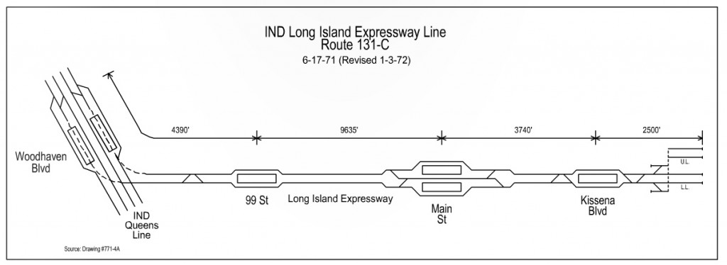
A branch off of the IND Queens Blvd Line at Woodhaven Blvd would run along the LIE. Presumably it was to run for a short distance in a tunnel and then come to the surface along the median of the expressway. This plan ultimately died when the NYS DOT expanded the LIE in the 1970s and 80s and left no room for transit.
If the LIRR Port Washington Line is brought up to Regional Rail standards and allows free transfers to the subway, then it is a de facto subway line and makes any extension of the 7 train to Bayside redundant. Therefore, we are free to reconsider where else the 7 could be extended.
Southern Corridor
The former Horace Harding Blvd was always seen as an important corridor. So much so that Robert Moses took the road for himself and expanded the formerly 6-lane arterial road into a full-fledged expressway. Naturally, he did so in a way which expressly prevented the future addition of transit along the median, as many of the expressways in Chicago had been built.
The corridor is home to two major colleges (CUNY Queens College and Queensborough Community College, two medial centers, two large shopping centers, and a number of dense post-War housing developments. Post-War planners saw the need to connect this corridor to transit, but running it to the nearby Queens Bvld Line may not be possible at this point (the plan to build a branch off of the subway was predicated upon the construction of the now-canceled super-express bypass subway line).
If we take a look at where the residents of this corridor work, we find the usual suspects (Manhattan) but also see a large cluster along Main St in Flushing. Bus ridership through this area is strong, aided partially by the fact that it lies between two regional sub-centers, Flushing and Jamaica.
An extension of the 7 train along this corridor would be well traveled. While it would not connect downtown Flushing and Jamaica, it would shorten trips between the two via a bus-to-subway transfer. Analyzing work inflow-outflow data, it is estimated that this line could see up to 50,000 riders a day. This makes it the corridor with the highest potential initial ridership. There is good redevelopment potential at station locations, and it is presumed that there will be high bus transfers to Jamaica and Great Neck.
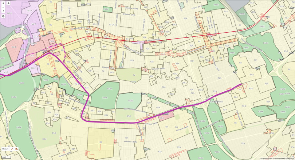
If the 7 train is to be extended along the LIE, it must first turn south from Roosevelt Ave to do so. Kissena Blvd is the most logical choice as running along Main St would require the 7 train to make a ridiculous backwards turn. Kissena Blvd also has a larger catchment area with dense apartment buildings on both sides.
There are two options for extending the 7 train along Kissena Blvd:
The first would be to extend the existing line after the Main St station eastward along Roosevelt Ave and turn down Bowne St. Going south, the tunnel would have to dive deep and tunnel under private property from Sanford Ave to the intersection of Cherry Ave and Kissena Blvd.
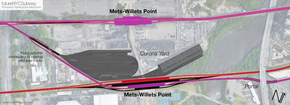
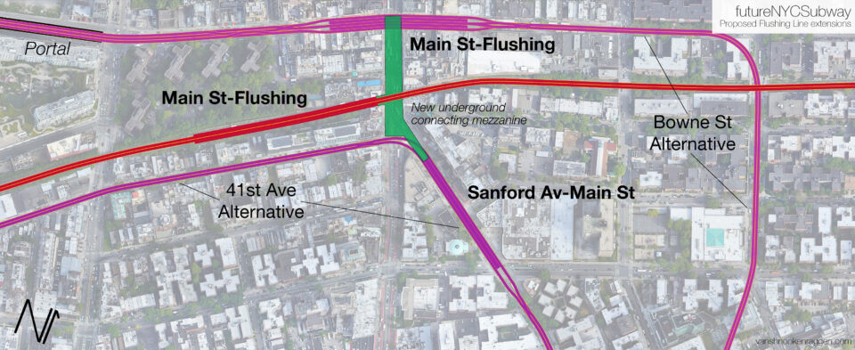
The second option would be to begin the new branch right after the 111th St station. Here, the Flushing Line has 5 tracks, two local, one express, and two layup tracks that connect to the Corona Yard. By using this yard connection, a new set of tracks can be extended over the LIRR before the Mets-Willets Point station (LIRR) and run along the south side of the LIRR tracks until 41st Ave.
The new subway branch would then tunnel along 41st Ave to Main St the tunnel would curve southeasterly along Kissena Blvd. A new station would be built under Kissena Blvd between Main St and Sanford Ave. It would be beneficial to have a new underground mezzanine connecting all Main St stations.
The Kissena Blvd subway would have a station in the vicinity of Elder Ave and 45th Ave. The tunnel will continue along Kissena Blvd until Oak Ave where it turns south, crossing Kissena Park Kosmos Soccer Field, and travels along 150th St until it reaches the LIE frontage road. The tunnel will then make a 90-degree turn east under the LIE to reach a new station at Kissena Blvd and the southern frontage road of the LIE. If such an extension is build in phases then this will be the new terminal and layup tracks will extend eastward under the LIE.
After Parsons Blvd the subway would emerge from the ground and run along an elevated viaduct built above the median of the LIE in the same fashion as that of the JFK AirTrain over the Van Wyck Expy. Stations would be at 164th St, Utopia Pkwy, 188th St, Francis Lewis Blvd, and Springfield Blvd. Layup tracks would be built past the Springfield Blvd terminal.
As an aside, there is a former railroad right-of-way (Central RR of LI) which runs parallel to the LIE; the Kissena Park Corridor was built along this ROW. It is not recommended to use this ROW for two reasons: the first is that ROW runs a half mile south of the central business district in downtown Flushing, and the second is that much of the land along the ROW was converted into park space and is rather far from any development. The LIE runs closer to where people are and where they want to go whereas the old ROW would only work as a collector for feeder bus lines.
Northern Corridor
Neighborhoods north of downtown Flushing, College Point and Whitestone in particular, once were served by a branch of the LIRR and had been promised a subway line at one point. Unfortunately, due to the abandonment of the LIRR Whitestone Branch and the lack of any subway infrastructure off of which to develop, much of Flushing north of Northern Blvd has developed with low density, single family homes. Only in the Linden Hill section, north of downtown Flushing, are dense apartment buildings found. Oddly, dense apartment buildings are also found in Bay Terrace, far from transit and on the literal outer edge of the city.
Because of the pattern of development, there are two corridors along which transit could be built. But both have flaws.
The first corridor mirrors that of the original IND Second System proposal. After Main St, the new subway would run along Roosevelt Ave to 149th St, with new stations at Parsons Blvd and Northern Blvd. Turning north along 149th St, the line would continue as a tunnel north to the Cross Island Pkwy where it would turn west under 14th Ave. Stations here would be at 32nd Ave/Bayside Ave, 25th Ave/Willets Point Blvd, 20th Ave, and the Cross Island Pkwy.
The line would then turn west, tunneling along 14th Ave to 138th St where it would become elevated, and turning south at 132nd St to 20th Ave.
In terms of construction, this corridor would be easier to build as the land is higher above sea level. But as the neighborhoods along this route have already developed in a suburban fashion, it would take a massive upzoning of these areas in order to justify the expense of a tunnel this long. Given that much of this area was still farms in the 1920s, the IND proposed extending the 7 this way as an elevated line to reduce the cost.
Upzoning a stable single-family neighborhood is sure to face harsh pushback. Even if the area was to be upzoned, it would take longer to build out since it would depend on the land sales of individual homeowners, rather than larger lots which are found in commercial or manufacturing zones. Therefore, any funding based on value capture would take much longer to pay back.
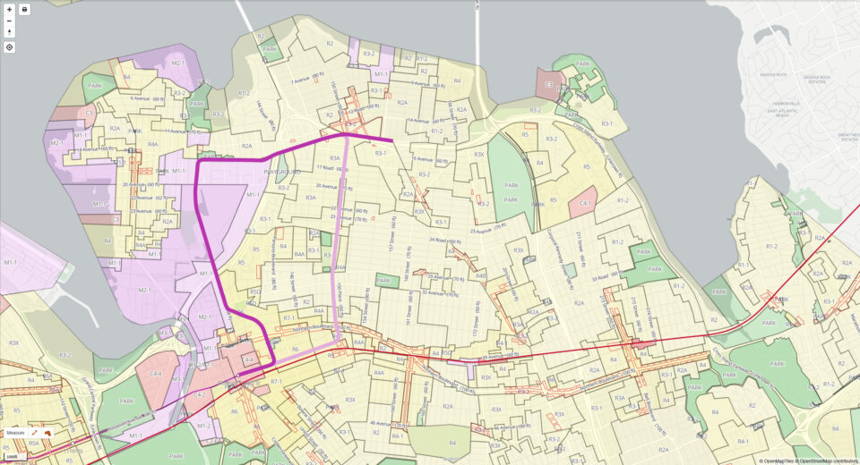
The second corridor is more complex but would have a better return on investment. Looking at a zoning map of Flushing, the most obvious place for a new transit line would be due north of downtown Flushing into College Point. Of all the possible corridors which could support a new rail transit line, this corridor stands out as the one which could most pay for itself with existing ridership and new development. Having an existing dense, mixed use corridor will give the line higher ridership when it opens and allows for more development once the line is open.
A College Point Line would have to be extended from the Main St station, going down Roosevelt Ave and turning north under Union St or Bowne St. A new station would be built at Northern Blvd. After this station the new tunnel would have to make a sweeping reverse curve to the northwest and then north along Linden Pl.
The subway would have to come above ground south of the Whitestone Expy. This is due to the high water table in the area. Much of this section of Flushing was at one point a salt marsh. Due to the geology of Long Island, bedrock would be very deep. Any such tunnel would have to deal with higher than normal volumes of water infiltration and would have to be designed to deal with this.
Any alignment along this corridor would have to deal both with taking property via eminent domain and reinforcing foundations for buildings not taken. This will add to the costs of the extension, but as has been mentioned, there is a better chance for redevelopment here which would offset the added cost.
The subway north of the Whitestone Expy, built on an elevated embankment, would run on the eastern side of Linden Pl to a station at 20th Ave. After this station the line would continue north above 132nd St, elevated, until it could turn east at Frank Golden Park. The line would run at grade until 138th St where it would enter into a tunnel along 15th Ave. The tunnel would continue along 15th Ave to Whitestone, with a terminal station at the Cross Island Pkwy and Clintonville St. The line could also be extended further east to Utopia Pkwy and Bay Terrace.
Analyzing work inflow-outflow data, we find that the 149th St alignment could see up to 35,000 riders a day and the College Point alignment could see up to 38,000 riders a day. The College Point alignment is better suited for redevelopment, which would attract more ridership in the future.
College Point and central Whitestone could certainly support new development, but the single family homeowners along 149th St would certainly fight back against such development. Even if rezoning went through, it would take much longer to redevelop the area lot by lot, rather than the larger, block sized parcels which exist in the commercial and manufacturing zoned areas.
Service
Being that we are proposing that the 7 train be split, it makes sense for one branch to be a new train while the other be an extension of the 7. Whichever branch gets built first would be the obvious choice to take the 7 title. The second branch would therefore be called the 8 train. Old timers may recall when there was an 8 train in the Bronx, along the old 3rd Ave El. Since there are no plans to bring that line back, the 8 would make a good fit next to the 7.
An alternative proposed as part of the Southern Corridor is for a second station at Main St in downtown Flushing. This station would be 550 ft south of the existing station. The benefit to this is that the platforms at the existing Main St station are rather narrow and struggle with the crowds it sees today. Should an extension be built (any extension), the station may not be able to handle the added traffic.
A second station to the south would relieve the current station of much of this traffic. It would also provide a transfer to the LIRR Port Washington Line. Because of the track layout, if the Southern Corridor is connected to the Flushing Line at 111th St, these trains can only run as locals into Manhattan. So a transfer to the LIRR as a de facto express would help. It may make sense to connect all three stations with an underground concourse that would allow pedestrians to avoid the crowded sidewalks of Main St.
Service would be similar to that of today’s Flushing Line with peak directional express trains. Local service would be split between 7 and 8 trains, with each seeing 15-18tph. This should be more than enough service for the two branches.
Travel times would be relatively quick.
- From Whitestone to Main St, via the College Point alignment, would be 16 min.
- From College Point to Main St, via the 149th St alignment, would be 17 min.
- From Springfield Blvd to Main St, via the LIE and Kissena Blvd alignment, would be 20 min.
Costs
Without a full engineering report we cannot know exactly how much these extensions will cost. But by reverse engineering costs based off the published 2nd Ave Subway costs, as well as the hard costs published in the MTA’s Rockaway Beach Branch study, we can get enough of an idea of what these projects will costs.
| Description | Cost | Unit | Total Cost |
| Kissena Blvd-Subway, Phase 1 2.2mi | |||
| Cut and Cover Tunnels | $210,000.00 | 1300 | $273,000,000.00 |
| Launch Box | $210,000.00 | 1 | $210,000.00 |
| Receiving Pit | $420,000.00 | 1 | $420,000.00 |
| TMB Tunnels | $40,000.00 | 9365 | $374,600,000.00 |
| Boat Section | $62,011,800.00 | 1 | $62,011,800.00 |
| Vent Buildings | $37,360,000.00 | 6 | $224,160,000.00 |
| Fan Plants | $14,981,750.00 | 6 | $89,890,500.00 |
| Underground Stations (Cut and Cover) | $100,000,000.00 | 2 | $200,000,000.00 |
| Systems | $27,000,000.00 | 2.2 | $59,400,000.00 |
| Hard Costs | $1,283,692,300.00 | ||
| Contingency (30%) | $1,668,799,990.00 | ||
| Subtotal Cost | $2,952,492,290.00 | ||
| Inflation (21%) | $620,023,380.90 | ||
| Total Cost | $3,572,515,670.90 | ||
| Kissena Blvd-LIE Viaduct, Phase 2 3.2mi | |||
| Viaduct | $1,200.00 | 660000 | $792,000,000.00 |
| Elevated Stations | $70,000,000.00 | 5 | $350,000,000.00 |
| Systems | $27,000,000.00 | 3.2 | $86,400,000.00 |
| Hard Costs | $1,228,400,000.00 | ||
| Contingency (30%) | $1,596,920,000.00 | ||
| Subtotal Cost | $2,825,320,000.00 | ||
| Inflation (21%) | $593,317,200.00 | ||
| Total Cost | $3,418,637,200.00 | ||
| College Point (20th Ave) Tunnel and Embankment | |||
| Launch Box | $210,000.00 | 0 | $0.00 |
| Receiving Pit | $420,000.00 | 1 | $420,000.00 |
| TMB Tunnels | $40,000.00 | 6600 | $264,000,000.00 |
| Boat Section | $62,011,800.00 | 1 | $62,011,800.00 |
| Vent Buildings | $37,360,000.00 | 5 | $186,800,000.00 |
| Fan Plants | $14,981,750.00 | 5 | $74,908,750.00 |
| Underground Stations (Cut and Cover) | $100,000,000.00 | 2 | $200,000,000.00 |
| Systems | $27,000,000.00 | 1.87 | $50,490,000.00 |
| Viaduct | $1,200.00 | 3300 | $3,960,000.00 |
| Elevated Stations | $70,000,000.00 | 1 | $70,000,000.00 |
| College Point Yard | $300,000,000.00 | 1 | $300,000,000.00 |
| Hard Costs | $1,212,590,550.00 | ||
| Contingency (30%) | $1,576,367,715.00 | ||
| Subtotal Cost | $2,788,958,265.00 | ||
| Inflation (21%) | $585,681,235.65 | ||
| Total Cost | $3,374,639,500.65 | ||
| College Point and Whitestone Tunnel | |||
| Launch Box | $210,000.00 | 1 | $210,000.00 |
| Receiving Pit | $420,000.00 | 2 | $840,000.00 |
| TMB Tunnels | $40,000.00 | 12461 | $498,440,000.00 |
| Boat Section | $62,011,800.00 | 2 | $124,023,600.00 |
| Vent Buildings | $37,360,000.00 | 8 | $298,880,000.00 |
| Fan Plants | $14,981,750.00 | 8 | $119,854,000.00 |
| Underground Stations (Cut and Cover) | $100,000,000.00 | 3 | $300,000,000.00 |
| Systems | $27,000,000.00 | 3.46 | $93,420,000.00 |
| Viaduct | $1,200.00 | 5808 | $6,969,600.00 |
| Elevated Stations | $70,000,000.00 | 1 | $70,000,000.00 |
| College Point Yard | $300,000,000.00 | 1 | $300,000,000.00 |
| Hard Costs | $1,812,637,200.00 | ||
| Contingency (30%) | $2,356,428,360.00 | ||
| Subtotal Cost | $4,169,065,560.00 | ||
| Inflation (21%) | $875,503,767.60 | ||
| Total Cost | $5,044,569,327.60 | ||
| 149th St-College Point Tunnel | |||
| Launch Box | $210,000.00 | 1 | $210,000.00 |
| Receiving Pit | $420,000.00 | 1 | $420,000.00 |
| TMB Tunnels | $40,000.00 | 16420 | $656,800,000.00 |
| Boat Section | $62,011,800.00 | 1 | $62,011,800.00 |
| Vent Buildings | $37,360,000.00 | 13 | $485,680,000.00 |
| Fan Plants | $14,981,750.00 | 13 | $194,762,750.00 |
| Underground Stations (Cut and Cover) | $100,000,000.00 | 6 | $600,000,000.00 |
| Systems | $27,000,000.00 | 3.93 | $106,110,000.00 |
| Viaduct | $1,200.00 | 4309 | $5,170,800.00 |
| Elevated Stations | $70,000,000.00 | 1 | $70,000,000.00 |
| College Point Yard | $300,000,000.00 | 1 | $300,000,000.00 |
| Hard Costs | $2,481,165,350.00 | ||
| Contingency (30%) | $3,225,514,955.00 | ||
| Subtotal Cost | $5,706,680,305.00 | ||
| Inflation (21%) | $1,198,402,864.05 | ||
| Total Cost | $6,905,083,169.05 |
We are not here to do a deep dive into the exorbitant MTA construction costs. Needless to say, if these costs came down then extensions like this would be more feasible. But from this back-of-the-envelope sketch we see that an extension to College Point via Linden Pl would be able to recapture much of the costs of the project from real estate redevelopment along the corridor. Extending this line further to Whitestone adds about $2 billion and it is less clear if rezoning would be able to recapture this investment. There are other costs which have not been accounted for, namely real estate acquisition and the cost of a new train yard in College Point.
The Kissena Blvd alignment would have similar costs, but denser zoning along the LIE would attract higher initial ridership and would allow for “easier” redevelopment along the expressway. It is envisioned that the subway portion and viaduct portion of the branch would be built as two separate phases.
The 149th St alignment, the one first proposed by the IND Second System, comes in as the most expensive option since it is assumed that this line would need to be tunneled for almost the entire length. Rezoning this corridor would be more difficult and would take far longer to recapture the costs, if it ever could.
Next Steps
As Queens will continue to grow, Flushing and its surrounding areas will become denser. For decades, NIMBYs would oppose this extension and nothing ever gets finished. However, as more young people replace the older generation, more people will be open to a 7 train extension. More representatives and grassroots groups are speaking up about better transportation alternatives like the QueensLink. With enough support, we can always find the money for what we want to build. We just need the political will to achieve this.
To turn these ideas into reality, we need to fight for them to be implemented. So far, we have created a petition and started building a coalition with like-minded groups. What is needed next is for the city and state to work together to create a holistic long-term plan for Flushing. This will only be accomplished by speaking up and putting pressure on elected politicians to take the plan seriously.
To get involved with the Tech Transit Association, follow them on Instagram, Twitter and YouTube.
7 extension alternatives: The Bowne St idea for a southern turnoff (since Bowne St is far too NARROW) is ridiculous. (You even note that the tunnel would have to be built DEEP UNDERGROUND because of the dynamics of the street above). What about a PARSONS BLVD turnoff instead? Parsons Blvd is WIDER at the turnoff point than Bowne St is (and that stop could serve as the turnoff point for BOTH the southern branch AND the proposed 149th St branch). Note that the 149 St branch would be better off starting as a northern “Parsons Blvd” branch, turning slightly right off Parsons at Willets Pt Blvd — a turn easily made by the Q 34 branch of the Q 25/34– with that line going to 149 St if you insist on a 149th St “branch”).
Furthermore, an argument can be made that the southern branch can further subdivided into a branch running north / south into Jamaica (via Parsons Blvd UNDER Kissena Park) to connect to your “Kissena LIE branch” except this branch would then be called the “PARSONS – LIE Branch” instead (note that the alternative Kissena connection is nearly impossible by rail from Parsons Blvd). There would be a stop at Parsons Blvd — LIE where these lines would branch off. Note that if QC feels the “need” to do so, they could (instead of running their bus shuttles north to the 7 train and south to Archer Ave as they do now), run a mini shuttle run from the southbound intersection of Parsons Blvd and the LIE service road via southbound Parsons, right on Jewel Ave, right on 150th St, right on Melbourne Ave (stop across from the campus), left on Kissena (with stops on northbound Kissena if QC and the MTA agree on such at the present MTA bus stops) and right on the south LIE Service Road back to Parsons Blvd and the route begins again (all these streets are wide enough for bus traffic — I know this because I live in the area!)….
Parsons Blvd is a road that has been disconnected and broken into at least three parts for long enough…. My plan would at least allow for its “recombining” into (most of) its component parts from the Malba area (albeit via rail instead of by surface transit) all the way to Jamaica. Comments, please…..
Parsons (going south) puts the line too far east to then have to swing down to Kissena. This is also why I much prefer the connection at 111th St and a tunnel under 41st Ave instead. And I would NOT branch these lines any more than they already are. I see value in a Flushing-Jamaica crosstown line down Parsons. But I see a high cost that would be prohibitive.
Parsons Blvd itself merges with Kissena Blvd just south of 75th Avenue (near Kennedy HS), so there is no need for that potential subway line to “swing down to Kissena” from Parsons Blvd. At that junction, Kissena veers off to the left (going northbound) while Parsons Blvd continues straight towards Electchester. My proposed route uses more of the full length of Parsons Blvd (even the parts that are broken up by Kissena Park and the LIE), so that “swinging” argument is simply wrong.
The 41 Ave / 111 St idea is an interesting one, but you might want to try using existing track to do so (i.e., using the track / tracks that go into the Corona Maintenance Facility just north of the LIRR Port Washington branch tracks). A diversion could be built at the point where those tracks turn left to the second part of the Facility (just AFTER the LIRR’s Mets – Willets Point station under the overpass for LIRR pedestrians to walk to Citi Field, so that an additional Mets – Willets Point stop — platforms on each side, perhaps — can be added at that location for part time use, if not full time use, for Kissena branch traffic as the next stop after 111 St). These new tracks then would head underground just before the yard itself (some interlocking would be needed for the trains to crossover as needed) and extended via a nearly direct East Rd (from the World’s Fair) / Sanford Avenue underground extension from the initial beginning of Sanford Ave at DeLong St (near CubeSmart), and then heading East towards a new stop at College Pt Blvd and Sanford Ave. Then the line would continue to Main St with a Main St/ Sanford Ave stop just before / after the Main St turn, similar in concept to the Steinway St / Bway stop on the M/ R local train — and then you’d have the Main St part of this branch as you wish.
I could still also have this Sanford Ave portion of the line running via the vastly underutilized Parsons Blvd, since Parsons can be easily reached via Sanford Ave east of Main St to allow for a Parsons Blvd ‘branch’ instead of a Main St branch. On Parsons there is a bit less traffic since the Blvd has been broken up by Kissena Park and the LIE — but an underground line on Parsons Blvd would solve those difficulties and reunite the Blvd as it was meant to be). This branch could have a stop in Electchester (at Jewel Ave – Parsons Blvd) which would serve a bunch of people who live in the many high rise buildings in the area– people of moderate income who would probably WELCOME a subway stop at Parsons Blvd and Jewel Ave with OPEN ARMS as an answer to prayer)….
BTW, why are there so few stops between Kissena Blvd — QC and the Main St / Sanford Ave station on your version of the LIE branch? If a goal of this project is to clear up traffic heading to/from downtown Flushing transferring to a bus, at least one additional stop (like @ the intersection of Main St & Booth Memorial Avenue serving [the ever busy] NY Presbyterian Hospital Queens DIRECTLY) would benefit hospital workers and visitors alike. What do you think of this idea?
You can more successfully argue that a north – south line down Parsons Blvd (whether or not it goes via Kissena Blvd in part) into Jamaica would be “cost – prohibitive”: however, I put that proposal in to show that there is another possible option for an extension upon the LIE subway extension via the almost forgotten about Parsons Blvd.
I like the 41st Ave/111th Street option better. I think that will make it easier to start construction. And the Main St-Sanford Ave station can serve as a much-needed relief station to Main St-Flushing. If it travels via Main Street, then it can effectively serve both Booth Hospital and Queens College. With stops at Sanford Ave and Booth Memorial, there shouldn’t be an issue with too few stations between downtown Flushing and QC. Though that would require a sharp right curve from 41st Ave (or Rd) onto Main Street, whereas a right onto Kissena would be more generous. But the Kissena alignment would put the 8 line some distance from Booth Hospital and would serve only one corner of QC.
With the Queens Bus Redesign underway, the (7) line extensions would make the Queens Bus Network more grid-like. The only route that will face elimination would be the Q17 because alternative service would be available, and the Q27 based on the Queens Bus Redesign will have to extend South to USB Arena with the Q26 (to Cambria Heights).
Only problem is there may be a need for a new Bronx to Jamaica Subway line parallel to the Q44 SBS along Kissena/Parsons.
The Whitrstone won’t fly, it existed and was replaced by the Whitestone expressway. What is lacking is north-south access. The SBS Q44 is pretty good, but the 7 could be extended to link to the E/F at Kew Gardens, which is, after all, the county seat. I use the Q44 heavily, to Briarwood F/E, to Flushing 7, to Parkchester 6 and to Tremont 2/3. I go to Columbia Q44-6-M60/100. I take Metro North at Fordham via Q44-Bx9. Nassau also needs a north-south line so you don’t have to go to Jamaica and back. Looking at Tokyo’s Yamanote line, the G could be extended to laGuardia, over Hellgate to follow the M60 then Ft Lee, Hoboken, JC, Wall Street, then close the loop in Brooklyn. Such a loop would help retail workers who work and live in mud-borough lower muddle class communities and now have extremely long trips.
Freeways are inherently unwalkable and hostile to dense or transit-oriented development. That makes a subway along the LIE a bad idea (it wasn’t a good idea in Chicago either).
Also, given that the 7 is already overloaded, upgrading the PWL will relieve it, but adding extensions that serve additional territory with upzoning will make it overloaded again. Maybe one extension of the 7 is OK, but two is too many.
For these two reasons I recommend cancelling the Kissena-LIE branch and instead only extending the 7 to the north.
As for the LIE area, a better line would follow Jewel Avenue or Union Turnpike. This could be an extension of the Queens Blvd local line. Or else if the N/Q is extended to LGA, it could be further extended to Willets Point and from there to the Queens College area.
I usually agree with you about subways along freeways. In the case of the LIE, however, there really isn’t a better alternative. The LIE was built out of a wide arterial road, similar to Queens Blvd. Because the road predated the highway, development and travel patterns already exist. Unfortunately, there really is no better alternative for a subway line to take than along the LIE.
The Kissena-LIE branch is actually the BEST one to build given potential ridership. It can also be built in a way which future-proofs it to allow it to be connected to a new subway along Norther Blvd. As you rightly state, at some point in the future the subway will be at capacity again. There was going to be a section on this, but we decided to cut it to speed up finishing the report.
Something to keep in mind is that Flushing attracts a lot of ridership by itself. That means that these new branches aren’t simply funneling everyone into Manhattan. The loads will be much more balanced.
I still prefer having the LIE line be a branch off the QBL only because the LeFrak City area is a VERY densely populated area and transit options other than buses are somewhat limited. A branch off the 7 would miss that area entirely, whereas a 7 extension to College Point/Whitestone would bring rail service to an area that has none and is somewhat cut off from the rest of North Queens by the Whitestone Expressway and the marshy remnants of Flushing Airport.
The 7 will be likely be crowded no matter what. I sometimes wonder if longer trains might be another tool to address capacity. The 7’s only connection to the rest of the system is via the N/W at Queensboro Plaza, so it’s on the same radio frequency as the B-Division and uses the same type of countdown clocks. But due to the narrow width of the Steinway Tunnels and the subway leading to them on both sides of the river, the 7 can’t use B-Division width cars like the R160s or upcoming R211s. But I always wondered if it could use cars that are the same width as the current R188 cars but 60 feet long like R160s and R211s. Or are there too many tight curves for 60-foot cars?
We can have is for the LIE branch to be built in a way that supports A Division standards with provisions to turn the line into B division standards. That way, in the future, when a branch off of Queens Blvd is built, the 7 LIE branch could end at Kissena Blvd, while the QBL branch takes over the remaining route.
As for the 7 being crowded no matter what, that is true. After all, the 7 is one of three subway lines that goes into Midtown Manhattan. We could use wider cars, but since Steinway was built with small tunnels and a very steep grade (as it was intended for trolley service), there must be extensive reconstruction made to Steinway. A better option is to upgrade Port Washington to a higher capacity and have fares lowered to a subway fare (within city limits). With East Side Access opening, there should be more capacity for the LIRR, and Port Washington could use that. This would help take off riders from the 7, especially in Flushing, Corona, and Jackson Heights where a lot of the ridership is.
Exactly. Steinway can’t take wider cars, but can it take longer cars? That’s what I’d like to know.
As someone who lives in Whitestone and rode the 7 daily from 2010-12 and 2015-20, I was very happy to read this entry. I know first hand just how overburdened the 7 is (even in these post-Covid times), especially the express. Though I agree with Eric2 that there should be just one extension north and that PW LIRR should get a big bump in service frequency and fare integration with the subways and buses. I do think there should also be a subway line to the LIE vicinity, but it should be a branch off the Queens Blvd Line, not Flushing.
As for the Whitestone 7 extension, I think it should have another station in between Clintonville St and 20th Ave to serve parts of College Point that are far from 20th Ave.
I think it would be very possible to have another station or two on the College Point branch. These were the ones that made the most obvious sense.
But after having read the entry again, plus the other comments, I’ve had a change of heart. I think the branch to the south should be built first. It would be easy – relatively – to start it by branching off the Corona Yard leads and it can have a station in downtown Flushing to relieve Main St (the Sanford Ave station).
I like the proposal but The 7/8 trains will definitely become more crowded with the new riders that the propose extensions.
So I plan to try to build a IND Northern Blvd line to reduce crowding The first part of this plan would be to expand the current 2nd Avenue plan. I propose building phase 3 with express tracks where a new line would branch using the existing 63rd street tunnel.
The reasoning why I propose Northern Blvd/2nd Ave local trains using the 63rd St tunnel.
Is that It would allow would allow riders coming from 6th Ave, Queens blvd, Hillside the chance to easily transfer to the 2nd Ave Subway.
Both tunnels would meet at a new station in Sunnyside Yards and continue as 4 tracks east under Northern Blvd.
On court square the tracks would be connected to the tracks of northern blvd allowing for the G train to be extended via Northern Blvd
The crosstown G train would branch out to Whitestone expressway and run to college point blvd. The Manhattan i name would be H train 2nd Avenue Express and V train 2nd Avenue Local. I’m proposing to either connect the H train to the Rockway Branch line via junction blvd or extend it down to LaGuardia Airport
It conclusion this line would feature an extended crosstown G train and a new 2nd Avenue H/V train lines
We had planned on including a section about a Northern Blvd subway but felt that it was better to focus on what regional rail could do for the 7 first since it would be vastly less expensive than what you’ve described.
We’ve spoken about this before and, despite the improbability of it, I would love to see the 7 Train extended further south from Hudson Yards to 14th Street to meet with a westward extension of the L Train.
Is it THAT “improbable? Not so much…. The gauge on the 7 train is the same as that on the L train (since they are both based on old BMT specifications as opposed to being on IRT stock as the other numbered trains are), therefore no track manipulations need take place to put the 7 style trains on the L line or vice versa. If the extensions were made to link the 7 and L trains (via 10th Avenue, let’s say) the 7 and the L can become a single train service (called either the L or the 7) from Canarsie to Main St (and beyond as proposed here).
And if any extension of the Canarsie end of the present L to Spring Creek (ending at say, Gateway Center) or via the mostly abandoned railroad right of way heading southwest is added on to it, so be it. If the line is deemed to be “too long”, there can be a split at Atlantic Ave — East NY (where there is at least four tracks available to travel north or south from there) to have two become the southwest branch, let’s say, and have two remain as the continuation of the L train to its present terminal. (Referring to the January 21, 2021 post’s section 18: BMT Canarsie Line Extension (1968-Present)).