
[UPDATE] In the original version of this post, I suggested that express platforms could be built at 51st St/Lexington Ave. With new information, this is likely not possible. This post has been updated to reflect the new information.
Recently, the Mayor of Atlanta announced that the city would be investing in four new MARTA infill stations. MARTA (Metropolitan Atlanta Rapid Transit Authority) is one of the typical hybrid metro systems that were built after World War II. MARTA, like WMATA in Washington DC, and BART in the San Francisco Bay Area were designed as a response to urban freeways that had devastated older cities and lead to the growth of auto-dependent suburbs. They are hybrids in the sense that stations in downtown areas are usually spaced closer together (walking distance), while stations outside the city are spaced further apart (driving distance) and often included large park-and-rides.
This set up was designed to allow suburban drivers to keep their cars, but bypass traffic heading downtown. One could argue whether or not this was successful. But viewed in an early 21st Century lens, it seems to have only propagated suburban sprawl since there was no actual incentive to give up ones auto-centric lifestyle. This has far more to do with land use than a road vs. rail debate, and we are beginning to see denser transit-oriented development near existing suburban stations.
Still, suburban oriented transit often featured longer distances between stations. Sometimes this was due to the land use at the time, where new transit lines were built on the bones of older railroads that served small towns. Other times, it was because the lines were specifically designed to allow white suburban riders to pass through poor, minority urban neighborhoods. This is the case with Atlanta, which is using infill stations to right these past wrongs.

The argument against infill stations is often that adding a stop slows down travel for existing riders. For a small system like MARTA, this really isn’t much of an issue. But for a larger system like New York, there is a balance that needs to be found. In their recent 20-Year Needs Assessment, the MTA considered three infill stations: a 10th Ave station on the 7 train, an Elmhurst station on the LIRR Port Washington Branch, and a Sunnyside station on the LIRR Main Line near Queens Plaza. The LIRR often runs through lower socio-economic areas than the ones it serves further out on the island. In this way, infill stations would slow down the trips for whiter, wealthier commuters from further out, and the LIRR leadership (heavily influenced by suburban politicians) have resisted attempts to add stops.
The subway, on the other hand, serves all classes of New Yorker. The bulk of the system was designed before World War 2 and the rise of auto-centric suburbs, meaning that all station stops were placed closer together, within walking distance. Even the former steam and commuter rail lines that were converted into the subway date from a time before widespread car adoption. Therefore, the need for infill stations on the subway is far less than that of the LIRR or other metro systems. Yet, with the cost of constructing new lines in New York astronomically high, many have wondered where infill stops might be built to better serve riders for a fraction of the cost of new lines.
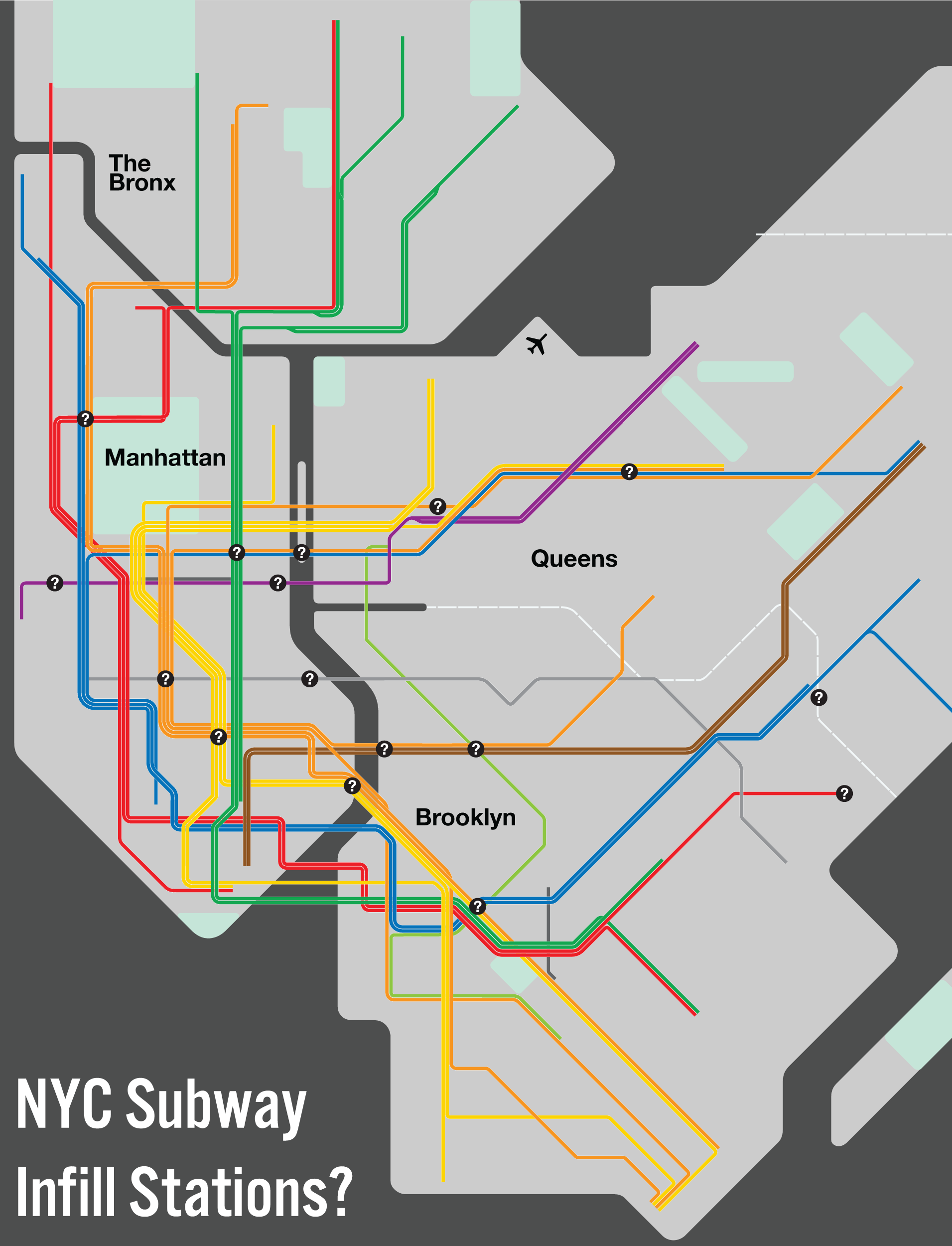
The question of new infill stations comes up a lot on the r/nycrail subreddit. This post in particular received a number of good responses, so I will use this post to respond to many of the proposed stops. My response will be broken into two parts: the stations that won’t work, and the stations that could work. I’m only considering new stations on existing tracks; one station extensions are not considered infill.
Not to fill
East River crossings
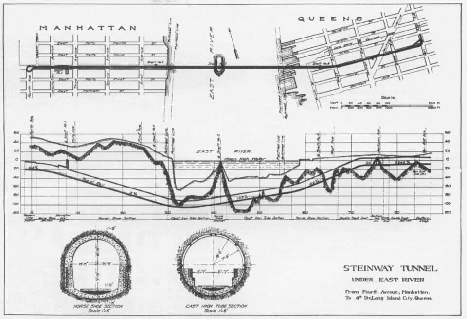
Being an island, subways between Manhattan and Long Island must dive deep underground to pass under the East River. Or, in the case of the Manhattan and Williamsburg Bridges, rise high into the sky to pass over it. These crossings are often long and in many places pass through neighborhoods with no other subway access. Stations have been suggested at Ave C and 14th St on the L train, 1st Ave and 42nd St on the 7 train, and at Columbia St or Wythe Ave on the Williamsburg Bridge.
To pass below the bottom of the river, tunnels must begin diving early, often immediately after the first/last stop before the tunnel. River tunnels have some of the steepest grades in the entire system, 4-5%. Likewise, subways which pass over East River bridges have similar, though often softer grades, 3-4%. ADA rules prohibit any new rail station have more than a 2% grade. Therefore, no new stations could be built within existing East River tunnels, nor on the Williamsburg or Manhattan Bridges.
6th Ave Lower Level
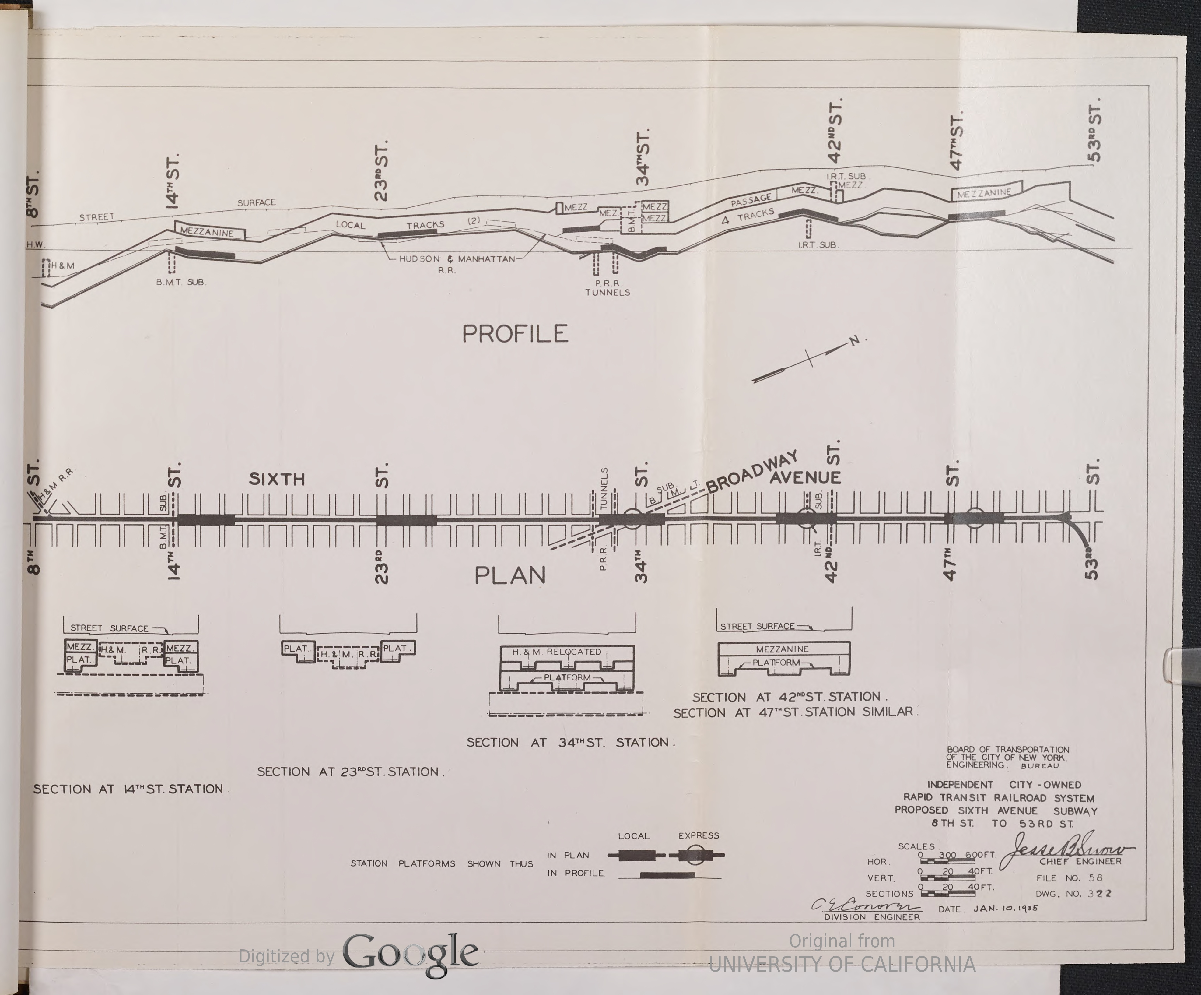
The IND 6th Ave Line opened in December 1940. Running from 9th St to 53rd St, this was the final piece of the original IND system to be constructed. The 6th Ave Line was designed to be a 4-track trunk line. Because of the pre-existing Hudson & Manhattan railroad (now, PATH) running between 9th St and 33rd St, the IND opted to only build 2-tracks along this section, with provisions for adding additional tracks later. Local trains from Washington Heights and the Bronx would terminate at 34th St, while express trains from uptown and Queens would continue south on the local tracks.
After the War, the need for the extra capacity became apparent. Proposals to add express tracks were drawn up in 1947, but it would be a decade before the project would be funded and construction started. Two new tracks would be built directly below the Hudson & Manhattan tunnel, connecting the West 4th St station with 34th St. No new stations were proposed, but the tracks were designed to be flat in the event that infill stops were needed.
Today, the 6th Ave Line runs four services, the B/D express and the F/M local; express trains skip 14th St and 23rd St. While 23rd St is a major crosstown street, all other trunk lines have only local stations at 23rd St. 14th St, on the other hand, is home to the L train, and all other trunk lines feature express stations at 14th St. Therefore, would it make sense to add platforms to the B/D express?
Likely, not. A rider coming from uptown has the option of taking the A/C/E or 1/2/3 trains which stop at 14th St for a transfer to the L. Likewise, anyone from Midtown could also take the N/Q/R/W trains and change at Union Sq. Riders coming from Brooklyn also have options to take the N/Q trains instead, or transfer to the 6 or F/M trains at Broadway-Lafayette. 14th St at 6th Ave was once home to large department stores, including the original home of Macy’s before it moved up to 34th St. But today there are far fewer attractions. With plenty of options and less of a reason to go directly to 14th and 6th Ave, few express riders would benefit from a station here.
Prince St and Broadway-Lafayette St
While not strictly an infill station, many people have wondered why no transfer was ever built between the R/W trains at Prince St and the B/D/F/M trains at Broadway-Lafayette St. Underground, the platforms are hardly 80′ apart, and a transfer was built to the 6 train at the Bleecker St station (though, originally only to the downtown platform due to cost.)
Simple connections like this are often called “low-hanging fruit”, but when it comes to ripping up city streets for years of construction, nothing is really “low hanging”. With a unified system since 1940, transfers between lines are free. This means that any rider coming from Union Sq can simply take the 6 train instead of the R/W trains. Riders coming from further north are that much closer to the B/D/F/M on 6th Ave, and can simply walk there and take the train directly.
Coming from the south and Brooklyn, a rider needing to take a Broadway train has the opportunity to transfer, or take a direct train, from Atlantic Ave, DeKalb Ave, or even Jay St. If a rider is trying to get to Lower Manhattan from the B/D, then the 6 train serves them just as well as the R/W would. Therefore, there really is no reason why a connection would need to be built here.
Atlantic Terminal on the Crosstown and Fulton St Lines
The IND was designed with many compromises. The Crosstown G train was cobbled together out of a number of previous plans. The Fulton St Line started construction before planners knew where it would even go, and tried to tie both together at one point to save money. Being built by the city, civic, political, and special interest groups had far more say in where lines were built than previously. All of this is why the A/C and G trains don’t actually serve one of the largest transit hubs in Brooklyn.
The LIRR first began running down Atlantic Ave in 1836, and opened a terminal at Flatbush Ave in 1877. The terminal was served by the elevated 5th Ave Line (but not the elevated Fulton St Line), and was the destination for the first subway extension in 1908. Subsequent subway extensions by the IRT and BMT in Brooklyn were centered on Atlantic Terminal, and all IRT and BMT lines stop here.
Being late to the game, the IND had to work with what was built before it. The choicest underground real estate through downtown Brooklyn had already been claimed by the original subway companies, so the IND had to wind a path through which could serve their new branch lines. This led the IND to choose Jay St-Smith St for its South Brooklyn Line, and Schermerhorn St-Lafayette Ave for its Fulton St and Crosstown Lines. This decision was a poor compromise, all things considered, as it placed the main transfer station (Hoyt-Schermerhorn Sts) two blocks south of the main business and shopping district on Fulton St, and one block north of Atlantic Terminal.
The IND had originally chosen a better path, one which would route their lines along State St and Hanson Pl, right next to Atlantic Terminal. This would have required routing the Crosstown Line down Fulton St, then along Gates Ave, turning north under Throop Ave. This alignment angered local merchants and landowners, who had been “promised” (i.e. paid a tax assessment) a subway under Lafayette Ave as early as 1912, and they fought to have the route changed.
The only way that a Lafayette Ave alignment could work was if the main transfer station was built on Schermerhorn St. In order for the two lines to meet in a way that provided a cross-platform transfer, the station needed to be located further west of Flatbush Ave. Heading east, the Crosstown Line tunnel dives under the Fulton St tunnel, crossing at Fulton St and Lafayette Ave. Here, we find the confusingly named Fulton St station on the Crosstown Line (under Lafayette Ave), and the Lafayette Ave station on the Fulton St Line (which is actually two blocks away from Lafayette Ave!)
A new infill station that would provide a block long connection to Atlantic Terminal could only realistically be built on the local tracks, served by the C. The tunnels here make curves between Schermerhorn St and Lafayette Ave, and between Lafayette Ave and Fulton St. The new station would have to replace the Lafayette Ave stop, as the station spacing is too close. This would disadvantage more riders coming from Clinton Hill. A new station here would be complicated and costly, and not really serve riders heading to Atlantic Terminal all that well; you’d still need an almost 700′ passageway underground to trasnfer. In 2008, former NYC Councilmember Letitia James asked the MTA to look into an underground tunnel between the C and G train stations to Atlantic Terminal. I’ve never seen the report, if it was ever produced, but I can’t imagine it was ever a viable solution.
The IND not having a station closer to Atlantic Terminal is certainly a planning blunder, but correcting this mistake would not be worth the high cost and relatively low convenience.
104th St and Central Park West Express
As far as I can tell, this is the most requested infill station in the system, and why not? Here are two major north-south trunk subway lines passing right by each other, one already with a station! It doesn’t really make sense. To understand why there is no stop on the 2/3 here, we have to understand what was going on when the IRT built the first subway.
We often forget that the companies that built the first subways were not operating in a vacuum. While the IRT was founded specifically to build and operate the first subway, its president, August Belmont, knew that it would be competing with the Manhattan Railway Company, which operated the elevated network in Manhattan and the Bronx. In 1903, a year before the subway opened, Belmont was able to acquire the Manhattan Railway Co. by lease, effectively combining the two systems.
At the time, there was an elevated rail line running along Columbus Ave through the Upper West Side. This line served trains along 9th and 6th Aves further south, while the new subway served Broadway before turning east at 42nd St to Park Ave. The 9th Ave El already had a station at 103rd St and Columbus Ave when the IRT began work. The IRT planned for its trunk line to split at 96th St, with a western branch continuing north under Broadway, and an eastern branch turning down 104th St to Central Park, turning north along Lenox Ave (now Malcolm X Blvd) before crossing into the Bronx.
A news article at the time shows that we, today, are not the first to ask this question. Residents at the time (1902!) were asking the same question. The IRT claimed that the grade of the tunnel would prevent a station (which didn’t stop them in other places), but residents claimed that it was because the IRT didn’t want to siphon riders away from the nearby el station. The IRT was funded by bankers who had interests in uptown real estate, so having additional stations meant that riders would have longer trips, and their land would be harder to sell. At the time, and even today, there is not that much at this location that would warrant an express stop.
Things changed 25 years later when the IND came uptown with its new 8th Ave Line. A major aim of the IND was to replace the antiquated elevated lines throughout the city, so it designed its new subways to mirror the existing service. As the 9th Ave El also served 6th Ave, the new IND developed a network with a trunk line along 8th Ave and a branch along 6th Ave. Central Park West (CPW) was the natural extension of 8th Ave, and offered somewhat easier construction along the park.
Another aspect of the IND was to correct design mistakes from previous generations of subway building. The IRT had built its first subway line with primitive (i.e. cheaper) junctions that required trains to pass in front of one another. Originally, one could get an express train from Washington Heights and a local train to the Bronx. This proved problematic, and eventually the IRT simplified service to that which we have today: 1 trains only serve Washington Heights, while 2/3 trains serve Harlem and the Bronx. But this led to crowding at express stations, where riders would jump between local and express trains to only save a few extra minutes.
The IND designed their new system for service to uptown Manhattan and the Bronx with a more balanced mix of locals and expresses. In practice, this meant that there would be no express stations between 59th St and 125th St so that express trains from Washington Heights and the Bronx would be kept free of riders trying to swap between locals and expresses along their route; CPW was left for the locals. Besides, if you lived in the UWS, you already had two epxress stops at Broadway.
With far fewer riders coming from Central Park, CPW local stations have lower ridership relative to the more centrally located 1/2/3 trains along Broadway. With lower ridership, the area of 104th and CPW never really needed a transfer station to be built on the 2/3. The IRT was a separate company until 1940, so having a station at CPW would have required riders to pay a second fare to transfer. After unification, a transfer to the 1 train at 59th St/Columbus Circle was provided. This station had always been a local stop, and while some at the time called for it to be expanded into an express for the 2/3, it would have only contributed to more crowding on the express trains.
In Midtown, the 8th Ave A/C trains and 6th Ave B/D trains are only ever a block away from the 7th Ave 1/2/3 trains. In Harlem, the A/C/B/D splits the difference between the 1 train along Broadway and the 2/3 trains along Malcolm X Blvd. 2/3 train riders have all the same access to Central Park of the UWS now as they would if there was a transfer station, and most would still stay on the express since the local CPW trains would only add to their trip time. There really is no reason to build a new station for the 2/3 trains at CPW.
There is a logic to not having express stations stop at major transfer points. This can clearly be seen at 74th-Broadway on the 7 train where it intersects with the Queens Blvd E/F/R/M trains at Roosevelt Ave. At the time of its construction, the Queens Blvd Line wasn’t a thing yet, so express stations were built at 61st St-Woodside (for the LIRR) and Junction Blvd. The 7 express is designed to serve riders going directly into Midtown (it runs peak-directional service). If there was an infill express stop at 74th St, the expresses would be overwhelmed (as if they aren’t already) with most riders psychologically choosing an express over a local. Segregating local and transfer traffic from express through traffic is an effective strategy for reducing lopsided congestion (which we see on the Queens Blvd Line).
51st St on the Lexington Ave Line Express
When the IRT Lexington Ave Line was built as part of the Dual Contracts, the IRT had the rights to run elevated trains from the 2nd Ave El over the Queensboro Bridge to Queensboro Plaza, as well as operating rights to the Steinway Tubes (7 train). Service between Queens and Midtown was covered, both on the East Side and across town. Therefore, the Lexington Ave Line was designed more for UES and Bronx riders to quickly get downtown, with express stations at 125th St, 86th St, and 42nd St.
The success of the line soon brought growth to the area, and after World War 2, Midtown East became a home for massive corporations. Suburban growth in Queens meant more and more riders were coming in and transferring at crowded local stops. The city had torn down the 2nd Ave El in 1942, severing the connection between Queens and the East Side. This left only the 7 train, Broadway-Astoria Lines (today, N/W trains), and Queens Blvd Line to handle the surge.
While Midtown was certainly growing, Lower Manhattan was still the dominant drawn. This meant that a large portion of riders from Queens were transferring to the Lexington Ave Line at crowded local stations, only to then try and cram into crowded express trains at 42nd St-Grand Central. Something had to be done.
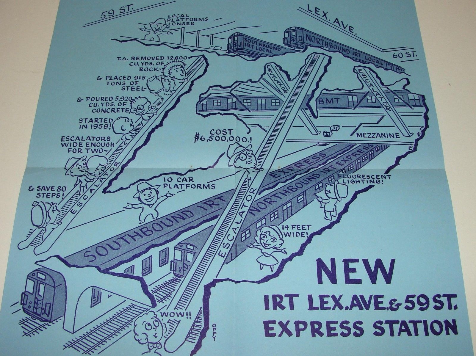
To alleviate the situation, the NYC Transit Authority determined that adding express platforms to the Lexington Ave Line at 59th St should do the trick. Lexington Ave is more narrow than its numbered counterparts. When building the subway, the IRT chose to build a double-stacked tunnel, with the local tracks on the top and express tracks on the bottom. At 59th St, the BMT 60th St Tunnel crosses between the local and express tracks. So the new platforms needed to connect to both the BMT mezzanine and IRT local platforms. The platforms were built while service kept running, and opened to much fanfare in 1959. It helped anchor Midtown East to the north. Soon this connection was not enough.

Congestion at 59th St and 42nd St was often so bad that riders from the Queens Blvd Line would, well after unification, take the E/F trains to Lexington Ave/53rd St, walk two blocks south, and pay a second fare to get back on the Lexington Ave Line. In 1969, the newly formed MTA developed a $2.5 million plan to connect the two stations, but the project was ultimately not funded. It wasn’t until 1989 that a free transfer passage was opened, part of a deal with Boston Properties, which was developing a new skyscraper on the site.
While this helped take some pressure off of 59th St and 42nd St, the local-only Lexington Ave station was never further expanded to handle the added crowds. The 51st St station platforms are relatively narrow, and the connection requires riders to navigate narrow stairs and passageways. Riders will still make the transfer to the express at 59th or 42nd St stations, delaying trains. Further, the deep IND station features a small mezzanine with long stairs and escalators, rather than the usual overbuilt mezzanines found elsewhere.
When the city began planning what became the 63rd St Tunnel, plans initially called for a tunnel as far north as 79th St. Geological tests showed that tunneling north of 64th St would be more complex and costly due to the river bed, and a tunnel under 64th St would be too close to the Rockefeller Institute, so a tunnel at 63rd St was proposed. The City Planning Commission drew up alternative plans for a tunnel at 61st St, which would be close enough to the 59th St/Lexington Ave station to provide for a transfer. However, one of the main goals of the 63rd St Tunnel was to provide direct service to the new 2nd Ave Subway, relieving crowding at 59th St. Providing a transfer at 61st St would surely make crowding at 59th St worse.

The question, then, is would it make sense to add express platforms to the 51st St station? These would allow Queens Blvd Line riders more options to get to the Lexington Line express, reducing crowding at 59th St and 42nd St. In turn, this would reduce crowding on the 6 train at 51st St, where riders transfer to the 4/5 at the next station.
[UPDATE] In the comments of this post, it was brought up that the express level of the Lexington Ave Line drops down at some point before the 59th St station to allow the BMT 60th St Tunnel to pass through. The exact location of this change was not known, though I assumed it was further north. Thanks to the great work of subways.io, we now have a cross-section of the Lexington Ave Line showing the exact grade.
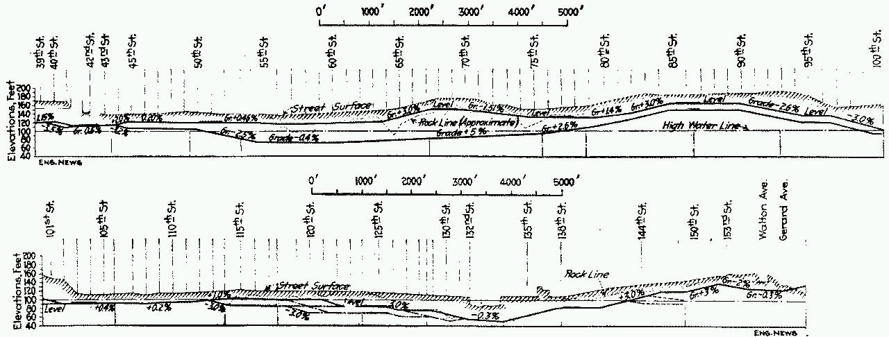
The grade change happens between 50th St and 54th St, right where the existing IRT and IND stations are. As the chart shows, the grade is 2.5%, which is too steep for an ADA compliant platform. This means, at best, a new infill station would have to be located between 48th St and 50th St. On paper, this doesn’t seem so bad. But in reality, this would put the new express platforms south of the local platforms. This requires riders that are transferring from the IND Lexington Ave station to walk another 850′ (which doesn’t include the vertical distance from the deep IND station).
The extra distance might mean that the total time it takes to transfer is greater than if a rider simply took a 6 train one station and switched to the 4/5. There is also the issue of space under ground. If the platforms could be built to connect with the existing mezzanine, then great. But with new platforms further back, there may not be enough space under the existing station to build a large enough passage. The new platforms would likely connect directly to the existing local platforms via narrow passages (with escalators and elevators, naturally). This will require any passenger that has the energy to walk from 53rd St to 50th St to also pass through the crowded local platforms.
Adding an extra stop for the express was always going to cause issues with slowing down trips for existing users. Making the transfer that much more difficult (and expensive) moves this to a non-starter. 51st-53rd St is the middle point between 42nd St and 59th St stations; if express platforms are built too far south or too far north of there, then the distances between express stops is too close on one side. All and all, this helps fewer riders. While it will be a long time before 2nd Ave Subway trains make their way south of 63rd St, ultimately, it will be the better option for Queens riders.
To fill
10th Ave on the 7 train extension
Of all the stations on this list, this one is the most disappointing. The station was included on the original 7 train extension to Hudson Yards, but was cut due to cost overruns. The 7 train extension was never something the MTA had any interest in, and was built because the Bloomberg administration had the city pay for it. Initially, the stop was to serve an Olympic stadium (until NYC was knocked out of contention for the 2012 games), then a new Jets stadium, before simply serving a new neighborhood (Hudson Yards).
The city wasn’t going to budge when the project ballooned in cost, so the intermediate station at 10th Ave was cut. Since the line opened, there has been some confusion over what was left for a future station. Nothing underground was ever built. However, when the MTA bored the tunnels, they left a level section where a station would go (similar to the lower level 6th Ave express tunnels.)
Because the 7 train extension had to navigate around the Lincoln Tunnel, Amtrak Empire Connection, and LIRR rail yards, it was decided to simply dig below everything. This required blasting large caverns for stations deep underground, with long egress ways to the surface, and a number of large ventilation buildings. The Hudson Yards station has one of the longest escalators in the system, as well as a specially designed inclined elevator. The final cost of the entire project was $2.4 billion ($3.175 billion in 2024).

In their recent 20-Year Needs Assessment, the MTA considered adding an infill station at 10th Ave but found it cost prohibitive at $1.9 billion. The 20-Year Needs Assessment, in general, is an overly myopic report designed to compare projects that aren’t truly comparable. The proposes station is surrounded by some of the densest development in Midtown Manhattan, and a large transit deficient neighborhood to the north that would benefit greatly. Additionally, the Port Authority is working on a replacement and expansion of the PA Bus Terminal adjacent to the site. Saying it wouldn’t attract enough ridership is a political feint. This infill station has, at least, strong political support in NY City Councilman Erik Bottcher. The 7 train extension may well be the red-headed stepchild of the MTA, and as such they are probably waiting for the city to step in once more and pay for a new station here.
Union Ave on the Jamaica Line
A station that I have championed for a long time now, and one that I know has at least been considered by the MTA, would be on the Jamaica Line (J/Z, M trains) at Union Ave. Located halfway between Hewes St and Lorimer St stations, the new Union Ave station would be a replacement for both, and offer a free transfer to the Broadway station on the Crosstown Line (G train) underground.
The lack of transfer here is a remnant from when the subways were run by separate, competing companies. When the city was building their IND system, one of their main goals was to replace the ancient elevated railroads that were slow, loud, dirty, and seen as an impediment to growth. For the most part, the IND was successful. The first (and only) phase of the IND was able to replace all the elevated lines in Manhattan (though it never did replace the 3rd Ave and 2nd Ave Els with a subway), and the Fulton St El in Brooklyn.
An ambitious second phase was planned that would have replaced the Brooklyn-Broadway section of the Jamaica Line, as well as the Myrtle Ave Line. These new subways would have integrated into the first phase at a number of places, most notably at the Broadway station on the Crosstown Line. Here, a gargantuan 6-track station would have been built that sorted riders from Queens and Brooklyn into Manhattan, along 8th Ave, 6th Ave and 2nd Ave. Early plans called for the Jamaica elevated to be removed between Williamsburg and Cypress Hills, with the Jamaica Ave section being connected to the Fulton St subway. Obviously, none of this came to pass.
Ever since, the Jamaica and Myrtle Ave Lines have been cut off from the G train. This may have not been much of an issue during the latter half of the 20th Century, when this entire area of Brooklyn saw massive depopulation and destruction. But in the last 20 years, northern Brooklyn has seen one of the most dramatic turns in modern memory. In 2010, the MTA rerouted the M train from Broad St to 6th Ave in response to historic ridership growth on the L train. While this has been a welcome change, riders on the G train (which has also seen historic growth) are still stuck with having only the L for access into Manhattan or Bushwick.
Creating a free transfer between the J/Z, M and G trains would shift more ridership away from the congested L, and greatly boost ridership on the J/Z and M trains. Northern, central, and downtown Brooklyn, despite the number of bus and rail lines, are still painfully disconnected. A free transfer between these lines would greatly reduce travel times within the borough, shifting riders away from Manhattan transfer stations.
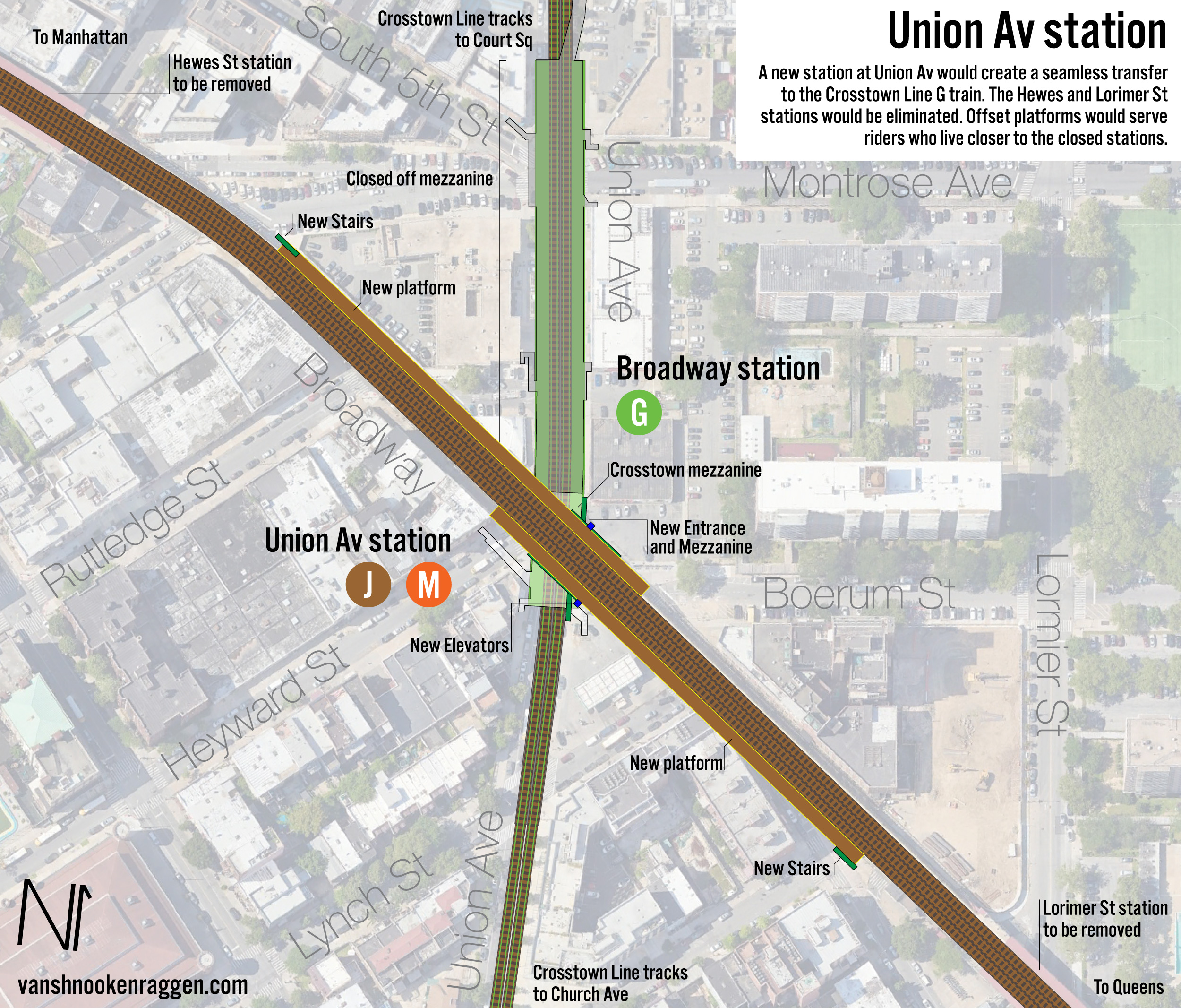
My proposal calls for the combination of the Hewes and Lorimer St stations. Some might see this as a reduction in service, but in truth, these stations are relatively close to one another and have lower ridership relative to the other Jamaica Line stations in Brooklyn. Because of the free transfer, the station would have a higher total ridership than both of the individual stops combined. The new platforms could be offset, so that riders coming from further away have a shorter walk to the new stop. There would be the added benefit of a slightly quicker trip for riders passing through on the J/Z and M trains.
Woodhaven Blvd on the Queens Blvd Line
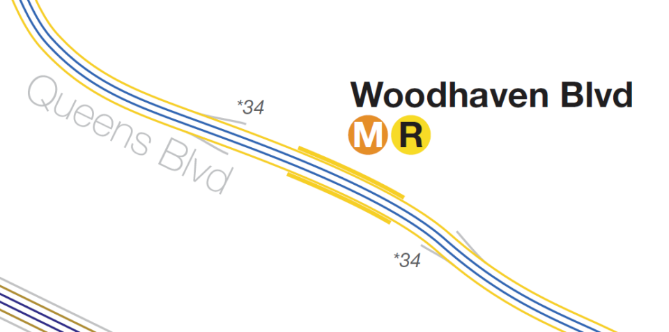
Of all the proposals on this list, this is the only one which A) was planned for from the beginning, and B) has actually been proposed, at one time, by the MTA. The IND Queens Blvd Line was constructed along with its eponymous roadway. The project was part of a larger plan to develop Queens (which was still mostly farm land well after World War 1), and included building of other arterial roads such as Woodhaven Blvd and Horace Harding Blvd. Planners knew that the new roads and subway would bring development, but because they were dealing with a relatively empty canvas, they chose to leave the express stations for where development (and ridership) justified them. They could see the potential for Woodhaven Blvd station being a center of future development, so the station was designed for a future conversion.
At either side of the local platforms, a few dozen feet into the subway tunnels, exist bellmouth provisions; simple spaces in the track walls that turn out where tracks could one day be added. The side platforms would have their walls knocked down, and new local tracks extended on either side. The existing local tracks would be filled in, and platforms extended over them to reach the express tracks. Column placement between the express and local tracks were designed so that train doors would not be blocked. Additionally, the station shell is located below the Queens Blvd underpass, leaving space underground for the new tracks.
Woodhaven Blvd station has the highest ridership of any local stop on the entire Queens Blvd Line. It sits directly midway between Roosevelt Av and Forest Hills-71st Av, two highly congested stations. The normal MTA response to an infill station is that it would hurt more riders than it would help, but here that argument doesn’t fly. Congestion at Roosevelt Av, the first express-local transfer station between Manhattan and the Queens Blvd Line, is often bad enough that it delays express trains as riders switch between local and express. These delays would be mitigated by having Woodhaven Blvd station be upgraded to an express, where many of these transferring riders are heading to. Instead of adding more time to express riders, it would actually reduce travel time.
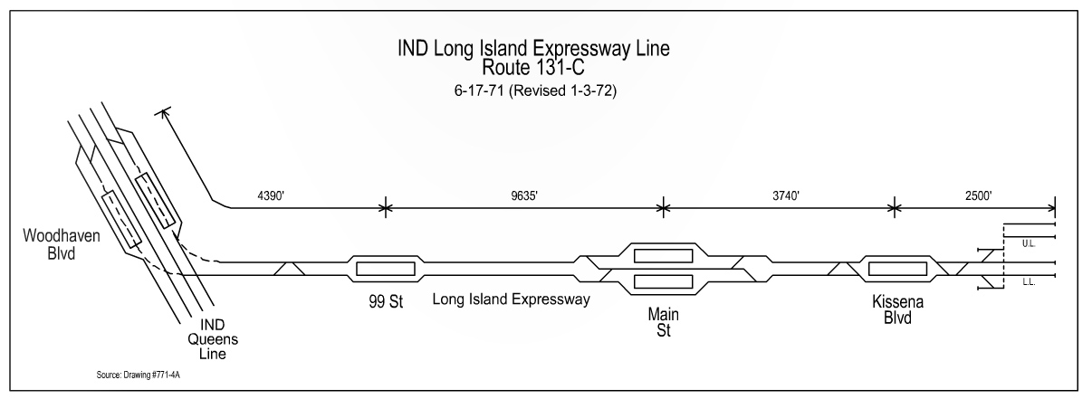
The last time this conversion was seriously considered was as part of the 1969 MTA Program for Action. The conversion was to be a part of the larger package of new Queens subways connecting to the 63rd St Tunnel. With the construction of the Queens Blvd super-express bypass, regular express service would see a reduction in ridership. This would allow for a new branch to be constructed off the Queens Blvd Line along the Long Island Expressway. The new branch would connect to both the local and express tracks just west of the Woodhaven Blvd station, which would be expanded into an express stop. The LIE branch would first run out to Main St in Queensboro Hill (Flushing), then get extended further east in a future phase. When the MTA and New York City hit a fiscal crisis in the 1970s, all work on projects not already under construction were canceled. With no super-express to provide more capacity, the LIE branch and Woodhaven Blvd station expansion were cut as well.
Today, Woodhaven Blvd station sits at a de facto edge city of sorts in central Queens. It is a hub for express and local buses, and home to Queens Center Mall and LeFrak City. Because of congestion on the Queens Blvd Line, this might also be one of the few expansion projects that the MTA would look kindly on, if they were to consider it at all (no mention of this was made in the 20-Year Needs Assessment). It might be possible that, should the Queens Center Mall get redeveloped, the new project could pay for the conversion.
29th St on the 63rd St Line
As previously mentioned, when the MTA and city hit the fiscal crisis in the 1970s, work on all non-started projects was cancelled. The two that made it through were the 63rd St Tunnel and the Archer Ave Lines in Jamaica. Planning for a new Manhattan to Queens tunnel had begun after World War 2, but it wasn’t until the mid 1960s when the city got serious and developed the dual subway and LIRR tunnel. Since much of the Program for Action relied on in the tunnel creating new capacity within Queens, many of the other projects would have had to wait for its construction, regardless of the fiscal crisis.
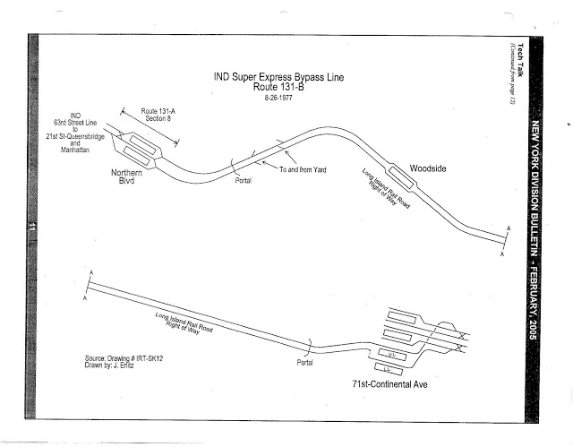
As originally planned, the 63rd St Tunnel was to connect the Broadway Line, 6th Ave Line, and future 2nd Ave Line with the Queens Blvd Line and a new, 2-track super-express subway that was to be built above ground and alongside the LIRR Main Line out to Forest Hills. Stations were planned at Lexington Ave, Roosevelt Island, 21st St-Queensbridge, Northern Blvd, Woodside, and a new lower-level at 71st Ave. Due to the lack of funds, the project limped along until 1988, where it opened as far as 21st St-Queensbridge (a “subway to nowhere”).

In 1984, planners looked at various ways to extend the line, including a simple connection to the Queens Blvd Line, the super-express bypass to Forest Hills, and even converting or building alongside the LIRR Lower Montauk Branch to Jamaica. At the end of the day, the MTA chose to build a connection to the Queens Blvd Line, linking both the express and local tracks. The new tracks would end up being located right where the previously proposed Northern Blvd station would have been. Provisions were added to the subway tunnel so that the line could one day be extended further east, potentially resurrecting the super-express, but this would still make adding a station at Northern Blvd difficult.
While the 63rd St Tunnel has certainly been successful, both for normal service and when work or emergencies require an alternative route, the lack of a station at Northern Blvd means that riders don’t have the ability to transfer to the Queens Blvd Line until Roosevelt Av. Here, riders switching between express and local often delay trains. The 63rd St Tunnel was designed to add more capacity to the Queens Blvd Line, which it has, but current service means that each local and express train must merge at a different location, delaying trains behind it. The combined effect is that the line still runs below what it could handle.
New side platforms would be built between Crescent St and 29th St, right up to the tunnel curve. A mezzanine would need to be built that would extend south along 41st Ave, connecting to the Queens Plaza station mezzanine. This connection would be about 600′. While certainly not ideal, it’s better than the alternative. Long Island City has exploded with growth over the last 20 years, so a new station here would certainly see enough ridership to justify itself, though the costs would still be high.
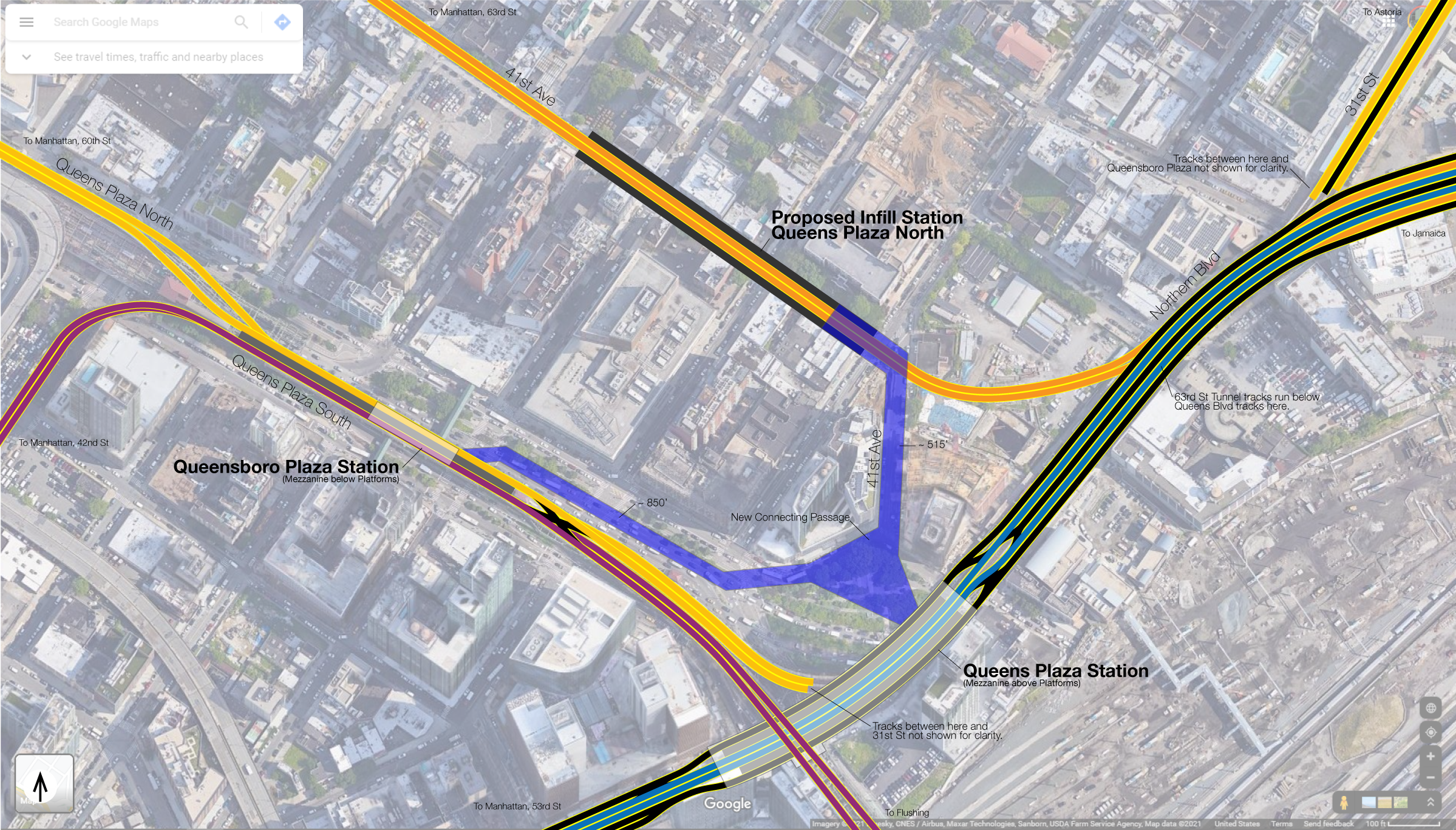
It’s doubtful that the super-express bypass would ever be built. The new station could be built with provisions for expansion that would allow for super-express trains to stop at outside tracks. Still, this is a solution for a problem a long ways off. Adding a station at Northern Blvd is certainly not a priority at the moment. However, if the MTA was ever to get serious about a deinterlining plan for the Queens Blvd Line, one which would segregate trains through the 53rd St and 63rd St Tunnels to either the local or express tracks only, then having an express-local transfer station at Queens Plaza would be necessary. Otherwise, half of the ridership would be cut off from where they want to go, and the other half would be stuck on trains just as full. The congestion at Roosevelt Ave would become worse.
No doubt, some of my readers will ask about expanding the 36th St station, the following local stop after Queens Plaza, rather than building out a new station at 29th St. Unlike the Woodhaven Blvd stop, 36th St was always intended to be a simple local station. 36th St does not have much space around it for such an expansion to make sense. That is, the stop is built relatively shallow underground (no large mezzanine), and is hemmed in on both sides of Northern Blvd by large buildings which would have to be supported during construction. Expanding 36th St would be far more clostly and disrupt service for far longer than an infill station at 29th St.
Linden Blvd station at Livonia Yard
Infill stations are not a new concept. As part of the first subway, Lenox Ave Line trains (not heading to the Bronx) had a terminal at 145th St, with tracks leading to the Lenox Terminal at 150th St. This area of Harlem was poorly served by streetcars and buses, and locals called for a station to be built at the yard. In 1968, such a station did open at 149th St and is today served by the 3 train. (according to Wikipedia, the station name was changed to Harlem-148th St so not to confuse riders with the 149th St station in the Bronx).
At the other end of 3 train, in New Lots, is a similar train yard. The Livonia Yard turns south at New Lots Ave, and straddles Linden Blvd. The 3 train runs through the heart of East New York, but large areas south of Linden Blvd are cut off from subway access. These include huge public housing developments, Starrett City, Gateway Center, and an industrial zone. Planners have wanted to extend service to this area for generations. The IRT included provisions for an extension east along New Lots Ave. In the 1960s, when much of this area was still undeveloped, an extension of the 3 train south to Flatlands Ave was put forth, only to be replaced by a more ambitious plan to reroute the L train along the median of a proposed highway through the area.
In their 20-Year Needs Assessment, the MTA considered a 2-stop extension of the 3 train south to Flatlands Ave, or deeper into Spring Creek. Both were deemed “not cost effective”, though the report did mention that its primary benefit was serving “equity areas”. Currently, the MTA runs a number of bus lines along this corridor to the New Lots Ave station, so in their mind the service is already provided. While obscene MTA costs will always be an excuse for not building small, common sense extensions, it’s worth considering that a single station built at Livonia Yards would be far cheaper and still serve the area south of Linden Blvd (which is one of the most dangerous and inhospitable streets in the city).
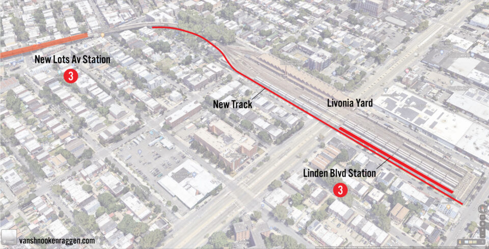
While I set out strict guidelines for this list of not building new tracks, this is the one station where I have to bend that rule. A new island platform would require the removal of one yard track (reducing capacity), but more importantly, it would make moves between the new station and the yard more complex. These movements would block revenue trains, causing delays. To mitigate this, a third track would be added between the New Lots Ave station and the new Linden Blvd station. This extra track would allow non-revenue trains to be moved without blocking revenue trains. Additionally, the lost capacity could be made up by adding a third-track along the center of the existing elevated structure west of New Lots Ave station.
A single station built on the existing viaduct would be cheaper than a full extension to Flatlands Ave, but would probably attract less ridership overall. If such a project was to be pursued, it would have to be the city that would pay for it. The MTA considered transit equity, but serving these areas doesn’t pay their bills. It’s the city that would see the overall benefit of the station, not the MTA, so it is in their economic interest to push for it.
Pitkin Ave Yard station
Similar to Livonia Yard, the Pitkin Ave Yard sits just past the end of the C train (Euclid Ave) along Linden Blvd, in a section of the city that is in desperate need of better transit. Pitkin Ave Yard is directly adjacent to the Pink Houses, Spring Creek, and possibly the most infamous neighborhood in New York, The Hole. The yard itself is topped by a large housing development built in the 1970s.
A proposed station would be similar to that of the Harlem-148th St stop: a single track would be removed for a platform. Unlike Livonia Yard, Pitkin has a larger capacity and more flexible non-revenue tracks for moving trains. A major benefit to such a station would be better operations at Euclid Ave, where C trains currently terminate on a single local track (though, with current frequencies on the C train, this isn’t much of a problem).
Astute subway riders will note that the C train does not run at night, so a shuttle service would be required between Euclid Ave and the Linden Blvd-Pitkin Yards station. This area is also served by a number of bus lines which may not interest the MTA into making the investment. Like the previous station at Livonia Yard, this may need to be championed and funder by the city, though the cost should be relatively low since no new tracks are needed.
Conclusion
New York is lucky to have a system that is designed around the pedestrian and not the car. Infill stations can be a smart way to improve service, but not all are as simple to build as it may seem. Because the subway is so overbuilt, and its coverage often so redundant, many locations for infill stations would never see the ridership to justify the cost of building them. Just because someone would use a connection doesn’t mean that enough people would.
The MTA has considered infill stations and connections in the past, most recently at Court Sq in Long Island City, Fulton Center, and finally connecting the uptown platform at Bleecker St to Broadway-Lafayette St. Making connections easier is a great way to encourage more ridership. Obviously, not every connection has the same potential. But in a time when ridership is struggling to return to pre-pandemic levels, making the subways more accessible and convenient will be a worthwhile investment.
When MTA built the Court Square transfer connecting the 7 and G, they closed one block to cars and took over the street space to build stairs, elevators, and escalators. Something similar can happen to connect the G to the J, using New Montrose Ave for the transfer space, and plugging right into the existing east mezzanine of Hewes St. This could be an option if MTA doesn’t want to build two new platforms and tear down four existing ones. But stop consolidation would be nice here, and hopefully the removal of that gas station as well.
I do like how the platforms are offset though, forcing the primary entrances to lead towards the back of the train where, in both cases, the front is more desirable and therefore more crowded.
I would love to see both Linden Blvd stations built out. Because then a BRT layout can be considered on Linden Blvd itself instead of having to divert buses to New Lots Ave (the avenue itself, not just the (3) station). With that, I’d also like to see a new southern entrance at the New Lots Ave (L) station to allow an easier transfer to such a busway.
After a video I watched this weekend ranking options for partial and complete deinterlining for the Queens Blvd subway, I’ve been thinking about the super-express. It’s funny how three stations on this list are directly relevant (51 St, 29 St, Woodhaven Blvd).
With regard to using Hewes St instead of a new station, I’m willing to bet that building a 600′ underground passage is going to cost far more than building out a single new station at Union Ave.
How does offsetting the platforms on the combined Hewes/Lorimer St station help reduce travel times? Someone who lives further away would have to walk less in one direction, but wouldn’t they have to walk more in the other direction then? Yes, they can get into the station more quickly, but still have to do the same amount of walking overall, unless I’m missing something?
Also, thanks for the great post! As always, very much appreciate your well thought out content.
When I say it will “reduce travel times”, I mean that for other riders passing through. They will only have one stop instead of two.
Obviously, a longer walk is a longer walk. But any seasoned subway rider knows where to stand on a platform so they are closest to their exit. It won’t *feel* as long if they are within the station already.
Stop spacing is needed because Hewes Street & Lorimer Street are redundant to each other. You can walk for 5-7 minutes in from Lorimer to Hewes Street and vice versa. The only station that should be kept is Lorimer Street because it has a bus connection, sees more ridership, and it can serve as a transfer station to the (G).
That bus can easily move over one block.
Are the Lexington Express tracks flat enough to build an infill 51st St station? I had assumed they were on a grade to go down to the deep 59th St platforms.
Also, to connect QBL to the Lexington Express without the 11th St cut, what about a pedestrian tunnel between 59th and 63rd? IMO most of the reluctance to use that transfer is the vertical distance rather than the horizontal, as both stations are very deep.
Also, should a LIRR ESA infill station be built underneath the 29th St station? I would think so, as I wouldn’t think it’d be so much more expensive if you’re already building a station directly above it, and it would really help Queens interconnectivity, moreso than a Sunnyside station, which would be a lot farther from the subway.
Well, it’s possible the track grade is too steep, but I somehow doubt it if they built the tunnel structure together (having a flat area where the local station is). There is a point just north of there where the express level starts to dive, but this might be clear of that. It’s worth looking into.
An underground tunnel between 63rd and 59th is about 750′, which is pretty long. Granted, the Queens Plaza transfer I’m proposing is around 600′. I think the problem is that a 750′ connection by itself won’t be enough to attract enough riders, whereas a new station at LIC that connects to Queens Plaza (and possibly Queensboro Plaza) would attract more even with the higher cost.
I’m skeptical that a LIRR station there would attract all that much ridership. It’s not like you can’t get to LIC from the LIRR via the 7 at Woodside, or take the 7 to Hunterspoint Ave. Yes, it would improve the commute of some people. But from what it looks like, far more are going straight to Manhattan.
Re the grade, I’m not sure the flat section is in the right place, since it seems pretty close to 42nd. https://www.youtube.com/watch?v=kugQJN3Fnck (I’m not sure how else to estimate distances), the train leaves 42nd at 42:06, exits the interlocking and enters the flyunder downgrade at 42:25, goes flat at 42:37, and then enters the main downgrade at 43:08 until it enters 59th at 43:57. Counting by signal lights (not sure if they’re evenly spaced), lights 2-3 and 6-14 are on a downgrade, and only 3-6 are flat. So it seems like only a short section is flat, and it’s probably closer to 42nd.
The IND line wasn’t there when they built the tunnel, and they likely thought no express skipped stops was too much, or wanted a longer, shallower grade. Someone should look into it more accurately, though.
Also, I really wish the MTA had better data on transfers, as it’s hard to tell how willing people are to transfer without any good data. I will say that transfers like Times Sq-42nd to 42nd-Port Authority are farther, about 900 ft east-west, and since the ACE platforms are staggered, if you’re going uptown, you have to walk a decent distance north, too. The transfer tunnel still seems pretty well traveled, though. Times Sq-Bryant Park is also about 900 ft, too, and they opened that one recently.
As for the LIRR station, I think it would have tons of ridership if it had fare integration/subway fares. Obviously that’s not the case right now, but if you’re going to build a station on top of the ESA tunnels, it should be future-proofed. Almost all of the recent LIRR ridership growth has come at non-Manhattan NYC stations due to the city ticket. Meanwhile Long Island stations and the Penn Station are still doing much worse than pre-pandemic. If there were actual full fare integration and a $2.90 city ticket, I’m sure a LIRR station there would receive plenty of ridership. There’s your superexpress, already built, and not in the deep GCM that’s a super far walk, but right underneath the F platforms. LIC is also a major job center on its own, unlike Woodside, the 7 is already super crowded, and trains to Hunterspoint take capacity away from Manhattan-bound trains. A 29th St station wouldn’t. Plus it also provides redundancy; it would’ve been excellent during the recent 63rd St tunnel shutdown.
I referenced that video, too. From what I calculated, it seems that the transition in construction techniques happens around 52nd or 53rd St (I’m assuming an average distance between signals, even though this isn’t 100% correct). If the grade here is too steep, the express platforms could be moved further south (49th-50th St). That makes for a longer transfer, one which might be a harder lift given the costs. I’ve reached out to a researcher I know who might have an answer.
42nd St =/= 63rd St. Part of why 42nd St has so many passages is because there are just so many people to use them. The same would not be the same for 59th/63rd Sts which sits very much on the edge of the northern side of Midtown. Queens Plaza, on the other hand, has a stronger center of gravity, and connects with more trains to more places (similar to 42nd St). A passage at 59th/63rd St helps only those who want to transfer to the Lex, while a passage at Queens Plaza (assuming they also connect to Queensboro Plaza) allows riders a wider array of options.
LIRR: Now we are getting into the magical “what if” scenario, and you can’t really plan based on that. I support a Sunnyside station on the Main Line, but another underground station sees a higher magnitude of cost with less overall ridership (especially if Sunnyside, a cheaper station to build, is built). The biggest issue when it comes to any station in LIC is that LIC isn’t as big of a market as you think, given the development there. Most of that development has been residential, not commercial. The commercial development there has been in hotels, education (LaGuardia CC), health care, or government. Few of those riders are coming from LI (few, not zero). I also don’t subscribe to the idea that LIRR would ever run a true RER style service, meaning that at best you have a local stop on the Main Line that serves city riders (which is good), but still sees low overall ridership. I could be wrong, but assuming I’m at least partially right, I would much rather see what kind of system we could build and base demand for any 29th St station once its up and running. The line is already there now, so if there does come a day when there would be enough ridership for a stop, great. I just don’t see it now.
How’s the 59-63 tunnel 750′? It’s less than three blocks
That’s how long three blocks are.
Very interesting article, as usual, with good discussion of the various infill ideas. The one that I think I like the best is the Union Street/Broadway station idea. As mentioned, this would indirectly provide at least a little relief to the L, since it would be possible to transfer from the G to the J/Z/M to get to Manhattan as well. And I assume the cost, since it would mainly involve modifications of an elevated line, would be considerably less than some of the other ideas discussed in this article. It is amazing to me that one of the busiest stations in Brooklyn is Bedford Avenue on the L. This wouldn’t help with that, though. I also find the idea of adding express platforms to 51st St. and Lexington interesting. I have also wondered, considering the concerns about crowding on the Queens Boulevard Line, why they don’t bring back the V, at least for rush hours. Those would be 10 car trains versus the 8 car trains on the M. Granted, people like being able to take the M through the Chrystie St. connection along to 6th Avenue, but the extra capacity in Queens seems more important.
From what people claim (I don’t ride the QBL all that often), the M is still underutilized. Replacing it with the V wouldn’t make it any more popular, so providing North Brooklyn and Ridgewood riders with direct 6th Ave service is an overall greater benefit.
If the M is underutilized, I wonder if it would be a useful idea to consider a J/Z skip stop pattern for the QBL locals. If the R skipped 36th St., 46th St., 65th St., and Elmhurst Ave., with the M skipping Steinway St. and Northern Blvd., this would make the trip to Manhattan, especially on the R, faster and perhaps fast enough to encourage more riders not to feel the need to transfer at Roosevelt Ave., considering the heavy ridership at Woodhaven Blvd. and Grand St.
Sorry, Grand Ave.
Given current headways, I think most people would see that as a loss of service. It’s one thing to wait 3-4 min for a train, but having to always wait 6-8 min (even if some stops are skipped) would mean that people would be more likely to switch to an express, feeling that their trips have gotten longer.
What is your analysis of the Bergen St lower level? I think it would be a great addition to make the F express full time between Church Av and Jay St.
F should never run full time express. There is far higher ridership between Jay and Church than south of Church. Forcing that many riders to transfer, especially when there are stairs involved, would be a disaster. If the point of limited F express is to speed up trips from south of Church Ave, reopening Bergen does little for them.
Hi Van, have you considered that some of these more complicated transfers with construction costs that would be too high could be managed with OSIs (out of station interchanges)? Recently, there was an OSI added to Lorimer Street/Metropolitan Avenue with OMNY to allow people with disabilities to transfer between the L and G Trains by tapping OMNY at a special reader to give the rider a 30 minute grace period to re-enter the station at no additional cost using the newly constructed elevators. For example, I completely agree that building a 700 foot corridor underground between Fulton Street and Atlantic Avenue-Barclays Center would cost way too much for minimal return, but what about enabling an OSI between the two stations to enable a free transfer at street level? I know that technically Lexington Avenue-59th Street and Lexington Avenue-63rd Street, as well as Lorimer Street and Junius Street, also have OSIs, but I prefer the OMNY example because MetroCards are going away soon, and iirc, the way the other two OSIs work is that it just waves the fare if you tapped/swiped in within 2 hours which isn’t as elegant of a solution.
I think that is a very good technical solution. It should absolutely be considered for some of these. However, the transfer penalty does exist. (https://www.sciencedirect.com/science/article/abs/pii/S0965856417303117) So for a transfer to be used (especially when you’ve just spent hundreds of millions on building it), you need to make it as seamless as possible. This is why I prefer the Union Ave/Broadway infill station over just a free transfer to Hewes St (there is also the added benefit of one fewer stops and less operating cost).
I also worry that OSI will be used for the IBX in places where physical connections are needed. Some stops are close enough (like New Utrecht Ave) where OSI won’t be an issue. But at Broadway Junction, where they seem to be leaving a station out in favor of forcing riders to walk 1000′ south to Atlantic Ave, OSI will be a poor stop-gap.
I think the MTA should consider all options when deciding what to do about transfers.
With the 29th St-Northern Bl infill stop, where does the elevated 39th Av station enter into this, if it does at all? I’m wondering specifically about facilitating a transfer from a Manhattan-bound N/W to an outbound F that doesn’t involve a transfer at QBP to the #7, local to Roosevelt Av., or Manhattan-bound to Court Sq to catch an outbound E/M. Would demand justify some physical connection?
I’d say the 39th Ave stop is a bitt too far away, especially when the more important connection to Queensboro Plaza station is closer and serve more riders. If you’re taking the N/W, what’s the real importance for switching to the F north of 34th St? The trains are only ever a block apart.
The (L) desperately needs infill station in Alphabet City & Williamsburg to reduce overloads at 1st Avenue & the Bedford Avenue Stations in Manhattan & Brooklyn. CBTC is not enough to address congestion.
Central Park West’s ridership definitely demands an IRT infill station. Central Park West has horrible transfers and is always packed. The (2) & (3) will solve the issue of improving transfers
The (7) definitely needs two infill stations in Manhattan to allow transfers to the future Second Avenue Subway & the possible (L) train extension up 10th Avenue, since Grand Central will not be able to handle transfers by forcing people to walk.
The (C) doesn’t need an infill station at the Pitkin Yard, The (3) extension to Spring Creek makes the infill station at Pitkin redundant. Using the unused tracks at the unfinished 76th Street Station as the second system planned, reinstating the (K) Train running from 168th Street to Meadowmere via Conduit Avenue is a far better option.
The 63rd Street Line was constructed to serve as an alternative to the 53rd Street Line and a super express trunk line. Now I’m playing Devils advocate because on the one hand 63rd Street doesn’t see much ridership compared to 53rd Street and on the other the QBL’s capacity is strained because of merging conflicts at 36th Street & 75th Avenue. As to not disrupt service along the line with reducing delays the 29th Street Station is necessary. 53rd Street was always intended to be an express corridor. 63rd Street was intended for local service. You can tell because of the transfers along both lines.
L doesn’t need any new stations, nor is that possible, as I explained. Congestion isn’t that bad post covid, and if it ever does get worse, then the MTA should look into extending L train platforms to hold 10-car trains.
CPW doesn’t need the transfer. Ridership on those local stops is relatively low, and most riders are heading between Harlem/Upper Manhattan/the Bronx and Midtown. Adding a station does really nothing.
7 can’t have a station at 1st or 2nd Ave due to the grade.
An infill at Pitkin Yard is far cheaper than extending the 3 train (which isn’t likely anyway). Not only that, but these stops are a mile apart, so your logic doesn’t really work.