
I live in Windsor Terrace, Brooklyn a block away from the Prospect Expressway. Built in the 1950s by master builder and Parks Department head Robert Moses, it cuts through southern Park Slope (literally cutting through the glacial moraine) and divides Windsor Terrace before connecting to Ocean Parkway. Construction of the highway was as destructive as any of his roads and forced the removal of many homes and businesses.
When I see the traffic lined up at rush hour I try to imagine the area without the highway and my nice quiet, tree lined streets would be packed with traffic. Moses knew the need and what it would take to build such a road but he also knew that the road didn’t have to be just an eyesore.
All along the route from Park Slope to Kensington there were parcels of land left over from building the road. Moses turned all of these into parks and paths. One can walk along the highway from one end to another and there are seating areas built in overlooking the highway; where there is larger land he built parks. There is even a park-path from the height of the hill down to the nearest subway station at Fort Hamilton Parkway, though this is mostly closed off due to concerns from neighboring homeowners. So while he saw that the highway would cut apart the neighborhood he also understood how to knit it back together.
This is not to try and paint Moses as a saint, far from it. The community through which he was ramming his roads used the new park space as a bargaining chip to offset the losses to their neighborhoods. Other, less influential, areas of the city didn’t get to benefit from this urban design choice. But none the less it was a compromise that worked.
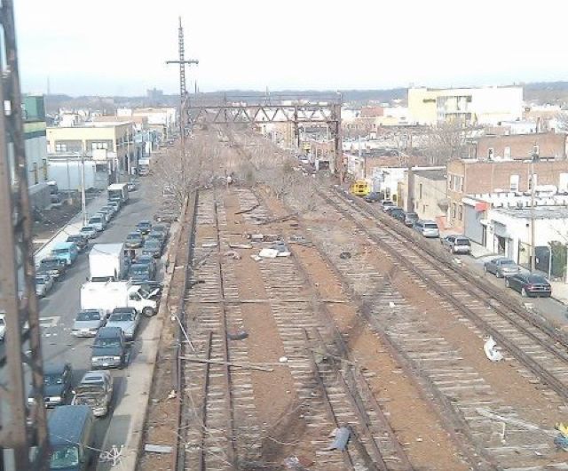
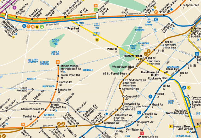
There is an ongoing argument in central Queens about public space verses infrastructure. The LIRR Rockaway Branch Branch is an abandoned rail line running from Rego Park to Ozone Park, paralleling Woodhaven Blvd. Built in the 1880 as a faster route to the Rockaways, the line once had stations in Forest Hills, Woodhaven, Ozone Park and Howard Beach. In 1950 the trestle over Jamaica Bay burned so, not wanting to deal with a costly rebuild, the LIRR sold the southern section to the city which converted the line into the A train which today serves the Rockaways. The norther section continued to operate until 1962 when it was abandoned.
As far back as the 1930s the city had considered connecting the northern section to the subway at 63rd Dr and Queens Blvd. The city’s IND subway proposed two different alternatives to service along the line which would have connected to the IND Queens Blvd subway. Seemingly ever since service was terminated, studies were drawn up looking at ways of reactivating the line, mostly for express service to JFK Airport. These often faced opposition from locals, whom the line would bypass. Because of this inaction the ROW has been allowed to deteriorate and be claimed by nature.
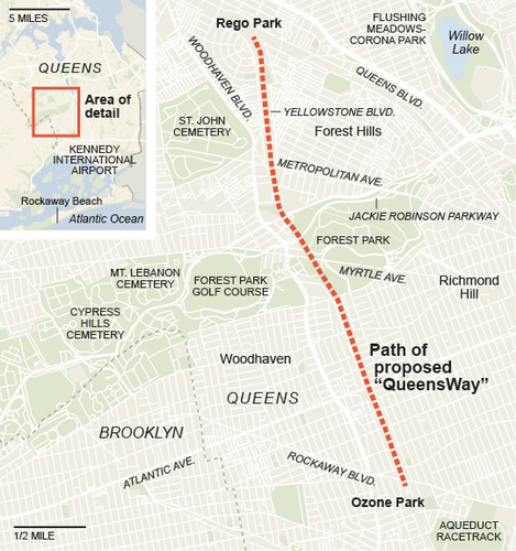
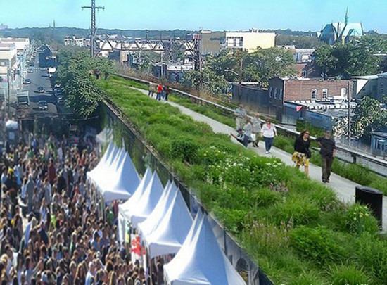
Inspired by a similar abandoned railroad known as the High Line, the Friends of the QueensWay stepped up with a proposal to turn the ROW into a linear park with no transit component. The success of the High Line was a shot in the arm for the rails-to-trails movement which before had seen most success in converting abandoned railroads in the suburbs or rural areas. The High Line was the first major urban rail line to be converted and gave inspiration for other abandoned rail infrastructure in older cities with industrial pasts. Queens residents were inspired and looked at the old Rockaway Branch as the perfect project. Thus was born the QueensWay. Governor Andrew Cuomo threw his support behind the project and green lit funding to develop a working design proposal.
But transit advocates balked at the idea of turning the only preserved ROW through Queens into a park, thus killing any chance of restoring train service. For many other rails-to-trains projects the ROW usually ran through an area that would not likely see the density of development needed to justify reactivation. The Rockaway Beach Branch was different as it ran through densely developed neighborhoods and paralleled a 6 lane highway that offered one of the only north-south routes through central Queens.
Woodhaven Blvd is currently the focus of a new Select Bus Service aimed at adding bus lanes with fewer stops to speed up travel. There has been well publicized resistance to the plan as it would take away parking and turning lanes which, as opponents argue, would increase traffic congestion. Restoring the Rockaway Beach Branch rail service would mean a faster route through central Queens and take cars off of Woodhaven Blvd. The city, state, and MTA have been cool to such a project so far given the cost overruns of basically every large scale rail project undertaken by the MTA since its inception. The MTA claims that rail service would only take bus riders off the road and not do much for traffic congestion. Local politicians have been mainly in favor of restored service but haven’t pushed the city to do more (though they did get the MTA to start a new study on restored service).
Last week an op-ed was published by Friends of the QueensWay throwing more fuel on the fire claiming that restoring rail service would be a detriment to the children playing in the nearby parks and distract students at nearby schools. They also claim that restored LIRR service would cost too much to ride for most southern Queens residents, take away riders from the AirTrain (which doesn’t even make sense since any subway rider would still need to transfer at Howard Beach to the AirTrain to reach JFK), and that any subway ride would be too long to reach Midtown to justify the costs. This op-ed, besides being laughably hyperbolic, points to the biggest issue we have in addressing the future needs of our city which is pitting sides against one another instead of finding common ground. Battle lines seem to have been drawn yet I can’t help thinking that both sides are right.
Restoring the Rockaway Beach Branch rail service would be a boon to all residents of Queens. The line would serve as the only north-south crosstown line and reduce traffic along Woodhaven Blvd, especially in the summer when the only option for anyone north of Atlantic Ave is to drive to the beach or take the Q53 bus from Queens Blvd. A subway line would reduce commute time into Midtown Manhattan and create faster commutes for those who work within Brooklyn and Queens. But park advocates have valid points about expanding park space (which is virtually impossible in this built up city) as well as connecting lower income neighborhoods with Forest Park. Building a bike network through Queens would be a game changer and give commuters a viable biking option through areas of the city dominated by automobile traffic. These are all ideas to make the city a better place.
So why is there even a fight?
Neither side has all the answers. The reasoning for building a new subway line along the Rockaway ROW is that it can just be reactivated for much cheaper than building a new line (such as the multi-billion dollar 2nd Ave Subway). What both sides fail to grasp is just how much of the line needs to be rebuilt.
The last trains ran in the 1960s and anything there, rails, bridges, stations, electrical equipment needs to be completely rebuilt. Also while the norther section from Rego Park to Forest Park runs above ground the southern section runs along an embankment which has not been maintained in almost 70 years and houses many small businesses on the ground floor. This will need to be rebuilt in parts if not totally. So the low cost aspect goes out the door; we are talking about a billion dollar project to start with.
Transit activists also need to seriously consider the noise impact of a new rail service that runs above ground. While many contend that buying a home next to a rail line, even an abandoned one, gives abutters little say in the matter, the truth is that we live in an age of environmental review and noise issues need to be considered.
The park space issue is more of a grey zone since Queens has some of the most park space of any borough, but there area areas which lack any space for even building a new park. Ozone Park, despite the name, has very little park space and the QueensWay would open a route through Ozone Park that would directly connect it to Forest Park. The High Line model is popular, but advocates need to consider that Chelsea was already a hot gentrifying neighborhood before the High Line was built. Just building a High Line but in Queens doesn’t mean it will work the same way (despite cheery renderings).
Removing the ROW from transit capability for good will condemn Queens to further automobile dependency. The High Line was in relatively good shape compared to the Rockaway Beach Branch which means a simple conversion to a trail is not as cheap and simple as park advocates would like to think.
QueensWay North
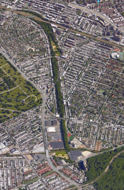
To me the answer is obvious: build both. The ROW needs to be rebuilt for either project so why not take the opportunity to build it for both.
The best option for service is to build a branch of the Queens Blvd subway; tunnel provisions were built between 63 Dr-Rego Park and 67 Av stations in the 1930s for such a branch. The new subway tunnel would run down 66th Ave past Burns St and continue in a tunnel to Forest Park. Building a simple box tunnel under the ROW could be done for much cheaper than if it ran under a city street; no underground utilities would need to be moved and the tunnel ceiling would only need to carry the new path above it.
The new path would seamlessly integrate into the existing parks along the ROW through Rego Park and Forest Hills. The park itself would start at 63rd Dr at the LIRR tracks and could use the vacant land once used for the LIRR Whitepot Junction. From 66th St/Fleet St south to Union Turnpike the line runs through the backyards of residents and where building a tunnel would be most beneficial in terms of reducing noise. The path above would then create a parkway from Rego Park south leading directly into Forest Park. This also avoids the issue of trains rumbling by the new school, though that argument against the line screams frightened suburban helicopter parent and should be laughed away.
QueensWay South
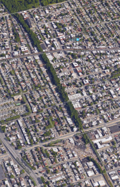
Just south of Jackie Robinson Parkway the subway would come above ground and from Forest Park south the embankment would need to be rebuilt. The lower elevation in southern Queens means that there is a higher water table and any subway would need to be expensively water proofed.
From Park Ln South to Atlantic Ave is the most difficult part because the ROW directly abuts the backs of homes. Park and bike space is sparse here so the path from Forest Park would need to run along Woodhaven Blvd. The frontage roads on the outer sides of Woodhaven Blvd would be reduced from 2 lanes to 1 with the medians being expanded for bike lanes. Atlantic Ave boasts a wide concrete median which can be reduced so that protected bike lanes can be built along the length from Broadway Junction to Jamaica without the need for eliminating parking.
These bike lanes would connect to a new park which is today a bus parking lot but was once used as a junction between the LIRR Atlantic Ave branch and the LIRR Rockaway branch. This park would run along the rebuilt embankment to 97th Ave.
From 97th Ave to Liberty Ave exists the old 4 track embankment with an abandoned station at 101-103rd Avs. This embankment may need to be rebuilt and if so would be rebuilt with only 2 tracks. It’s also questionable if this is the best place for a station as Atlantic Ave and Liberty Ave seem more suitable.
The extra space can be used as a linear park extending the bike lane south to Liberty Ave. The space under the new smaller embankment can be used for parks and markets in the way the QueeensWay proponents show in their renderings (see above).
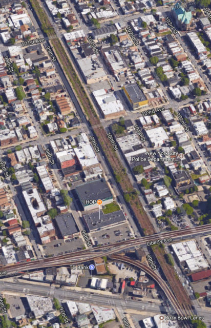
The southern section obviously lacks the park space of the northern section and improved bike lanes may not seem like a worthy trade off. The benefit would be that residents would have a subway to take them directly to Rockaway, Forest Park, or the expanded parks of Rego Park.
Landscaping the new embankment would also allow for noise reducing trees to be installed, further improving the neighborhood. Bike lanes could be extended south along Cross Bay Blvd and new lanes installed along Conduit Blvd and the Belt Parkway which today have expansive, but empty, landscaped medians. This last part is beyond the scope of the QueensWay but is in keeping with the desire to reuse transportation infrastructure for better park access.
Subway Service
Subway service would be via the local tracks of the Queens Blvd subway and this poses a problem. While improved subway service is needed, so too is a faster commute to Manhattan. Ozone Park has two subway lines (J/Z and the A/C), only one of which is express to lower Manhattan. A new subway would shave 15 min off a commute to Midtown but would require transferring to an express train on Queens Blvd.
The MTA is budgeted for upgrading the signals along Queens Blvd to the new CBTC system which is computer controlled and knows where all trains are at any time. This allows for more trains to run per hour and opens up capacity by about 10 trains per hour. The seemingly obvious answer is to just run more trains but ridership levels along Queens Blvd are not equal; ridership is highest between Roosevelt Ave and Forest Hills where local trains terminate (also express stations have much higher ridership than local stations).
Much of the congestion issue is along this section because riders prefer to switch from local to express at Roosevelt Ave even if local trains are less crowded. The solution is to convert the Woodhaven Blvd station, a local station, into an express station. When the station was built a future conversion was considered and provisions exist before and after the station for tracks to be expanded. While the new Rockaway Beach Branch would offer a one seat ride many would chose to transfer to an express train, as most riders do today at Roosevelt Ave. This often leads to delays because of crowding but if more riders could get on express trains sooner the crowding could be avoided.
Additionally, due to the fact that an additional local train would no longer terminate at Forest Hills there would be enough space there to allow for G trains to be extended and terminate at Forest Hills once again.
Money, as always, is the problem and this points to the city and Albany. The MTA, which ultimately answers to the governor, also stands in the way because it is in their best interest to do nothing. Building the line may not attract that many new riders which is the narrow way the MTA evaluates a project. The need is more about giving commuters another option that isn’t driving but this is on the city to push.
Mayor Bill de Blasio has proven completely ineffectual at consensus building and at this point isn’t even trying. His fallout with Gov Andrew Cuomo means that the city cannot push any subway project. Gov Cuomo seems to be anti-transit and has put money into studying the QueensWay park and would only benefit from keeping the pro-park forces fighting the pro-transit forces.
What is needed is someone to bring both sides to the table and see the common goal of both projects. It does not make sense to start building a park now when a subway would only require rebuilding the whole thing. The city needs a leader who can bring all parties to the table and find a solution that helps everyone. Construction costs need to be looked at too, especially now that the MTA is wrapping up the 2nd Ave Subway. If the project was financed primarily by the city, such as the 7 Line extension, the MTA would be much more open to the idea. The city has the most to gain here as it would directly benefit from the development along the line. Ridership growth is robust here and the city needs to be proactive for once; bus lanes aren’t going to cut it and new highways aren’t an option. If we continue on this one side takes all mentality then the city will suffer for it.
[Update]
After publishing this post, I was approached by the Executive Direct of QueensRail, the group which has been advocating for restoring rail along the line. I was invited to joing QueenRail and develop the ideas I outlined in this post. After some time, I helped create the QueensLink, a proposal to build a dual subway-and-park corridor along the right-of-way. You can find out more about the development from my recent post, as well as checking out our website, https://www.thequeenslink.org.

The method that Robert Moses used to finance most of his projects was to sell bonds through independent authorities such as the Triboro Bridge and Tunnel Authority and then to charge tolls. When the subway connection to Rockaway was originally made, a double fare was charged. Perhaps something like that could contribute to financing a project such as the one suggested here. Also, I like the idea of a “half-express,” but I think it would be more attractive to make the train along the new line be the N. It would run express between Roosevelt Av. and 21st St. and then go along 63rd St., at Lexington Av. switching back to the Broadway express. If the N and the Q run that way along the Broadway express and the R and the W run along the Broadway local to Astoria, there would be no more Broadway bottlenecks.
The method that Robert Moses employed is still in play in the Rockaways namely tolls on the Marine Parkway and Cross Bay Bridge that feed the MTA coffers. These dependence on these tolls act as a disincentive for the MTA to improve rail transit, the Power Broker himself would be proud. The above article is a well considered and well written plan, I can only surmise that Park and Rail are pitted against each other to ensure nothing is done.
You may have a point. The community feedback I always hear is that 1/3 is for park, 1/3 is for rail and 1/3 is for doing nothing. That’s a recipe for the status quo.
please consider tagging queensrail, queens public transit committee – I only found this article as I read your blog. Pro-rail constituents are not tagged above – thank you
Great idea! Thanks.