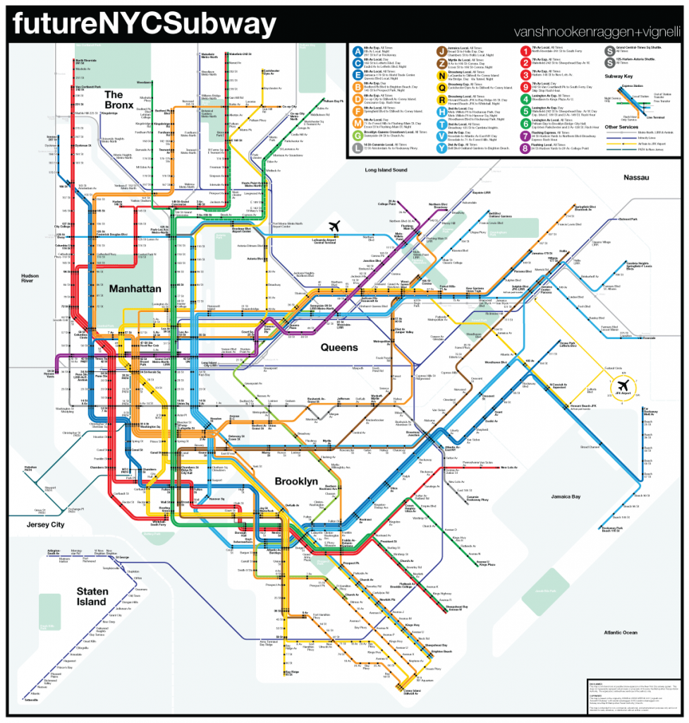
Two years ago I released an update for my futureNYCSubway series. Version 2 sought to create an updated and more realistic vision from that of the first FNYCS. Version 3 came soon after as a stripped down, budget conscience concept. Since then as I have spoken to more people about my ideas and as ridership on the MTA has hit all time highs I began to see the need for a new plan. As has been widely reported (and obvious to anyone who rides the subway) the ridership numbers throughout the system are up and especially along the L and M trains through Williamsburg and Bushwick as gentrification there continues at a breakneck pace. The MTA released its new 5 year budget and is $15 billion short. This includes money for Phase 2 of the 2nd Ave Subway which would continue the line (under construction currently) to 125th St. Maybe de Blasio, continuing with his support of rezoning East New York, Brooklyn for more affordable housing, has proposed building the Utica Ave Subway, a subway which predates the 2nd Ave Subway and one which has been proposed in various forms many times over the last 100 years. A think tank called ReThinkNYC led by Jim Venturi has released a far reaching plan which would greatly expand LaGuardia Airport and involve new subway lines to the Bronx and a massive new train terminal to connect the region to the new LaGuardia.
This has led me to rethink what I had proposed in the last version of the FNYCS. Much of the previous plans were built off of ideas that came from another era in New York’s history. The 2nd Ave Subway, as it is being built today, was designed at a time when subway ridership was stagnant and urban growth, especially in the Bronx, was small at best. Today the Bronx is seeing a population resurgence so constructing the 2nd Ave Subway with no express tracks seems short sighted. Growth in northern Brooklyn, an area which faced similar large scale depopulation in the 1970s as the Bronx, has not only recovered from the recession but continues at a pace which has seen subway stations ridership throughout Bushwick increase by double digits. New commuting patters from western Queens and an increase in reverse or off peak commuting means that a totally Manhattan-centric subway system should be rethought. A great inspiration for some of the new routes came from a New Yorker article looking at under the radar dollar van routes. Cost still remains the biggest hurdle for subway expansion so new routes need to be considered that take advantage of existing rights-of-way or reconfiguring existing lines for better service. Still, in many areas new tunnels are the only option. Intra-city commuter rail, which in European cities like Berlin, Paris, and London is integrated with subway service, is a flexible transit concept that could better serve the outer boroughs than fixed subway lines.
2nd Ave Subway
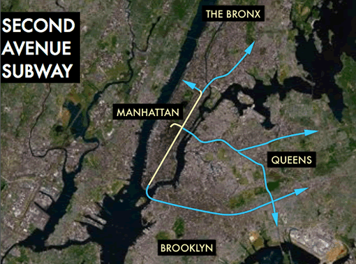
As I mentioned above the 2nd Ave Subway is currently being built as a 2 track subway from 63rd St to 96th St in Manhattan. Phase 2 would extend the line north to 125th St and Park Ave with a tail track under 2nd Ave for storage and future expansion. Phase 2 is up in the air until funding can be found but it is worth noting that much of the actual tunnels in Phase 2 were built in the 1970s but mothballed when the economic crisis hit the city. No tracks or stations were built but just having the tunnels themselves there will save time and money. But because the line is still only 2 tracks this limits how much service the 2nd Ave Subway can provide. Early plans called for express tracks which would spread new service throughout the Bronx. 2 tracks limits the tunnels to only two or three train services.
Dyre Ave
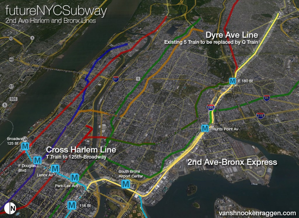
The most important extension and the one which would have the biggest impact is connecting the Dyre Ave Line (the 5 train today) to the 2nd Ave Subway via the existing ROW along side the Metro-North/Northeastern Corridor tracks from 180th St in Parkchester, Bronx, through Port Morris and south of Bruckner Blvd. Connecting the Dyre Ave Line to the 2nd Ave Subway is an idea which goes back to the 1920s and one which is been proposed in one form or another since.
Cross-Harlem
The other important 2nd Ave Subway branch would be a Cross-Harlem extension under 125th St to Broadway. Currently the only way to get crosstown via subway is in Midtown or 14th St where the subways are the most congested. A Cross-Harlem Line would balance the loads in Midtown and connect all of Harlem. Further expanding it across the East River to Astoria and LaGuardia Airport would create a triboro subway link which would allow for commuters to easily move between Queens, upper Manhattan, and the Bronx without a trip through Midtown (for more see South Bronx Airport Center below).
Phase 3
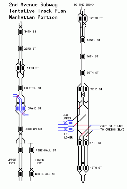
Phase 3 of the 2nd Ave Subway is still designed as a 2 track line but since we may be a generation away from even seeing a shovel in the ground for Phase 3 it is worth reconsidering the need for 4 tracks. The 63rd St Tunnel to Queens was designed with a connection to the 2nd Ave Subway so trains could run express to Forest Hills and beyond. Given the growth in ridership on subways in central Queens it will be important to get the most out of the 2nd Ave Subway where it connects to Queens. 4 tracks from 63rd St to Houston St would allow additional trains split between Queens and the Upper East Side so that more branches are possible in Brooklyn, Queens, and the Bronx.
Phase 4
Phase 4 of the 2nd Ave Subway is planned as a 2 track line south of Houston St to a terminal at Wall St-Hanover Sq. A track map I found from the 1970s shows a bi-level terminal, though by the time these plans were updated in the late 1990s I’m sure this has been reduced to a single level terminal for budget consideration. It’s worth noting that while the IND 6th Ave Subway was built with space for the 2nd Ave Subway and the Chrystie St Connection was built to allow for integration of the 2nd Ave Subway at Grand St station, neither connections are being considered for the current 2nd Ave Subway plans.
In version 3 of the FNYCS I proposed taking the BMT Centre St Subway (J/Z trains between Broad St and Delancey/Essexs Sts) and rebuilding the line as the southern section of the 2nd Ave Subway so that 2nd Ave trains could use existing tunnels to connect to Brooklyn. While this seemed like a better use of funds than building a brand new tunnel through the Financial District and possibly a new tunnel under the East River to downtown Brooklyn, I was swayed by an argument I read on the nyctransitforums.com which pointed out that 1) the subway under Delancey St would have to be rebuilt due to the geometry needed for the subway tunnel curves 2) this would require demolishing the Bowery station and possibly the Essex St station platforms on the J/Z line 3) that the stations along the line can only hold 8 car trains where IND stations (and new 2nd Ave stations) are built for 10 car trains and 4) the lines in Brooklyn which connect to the Centre St subway are already at capacity. This means the actual cost of converting the Centre St Subway and finding space for all the displaced trains in Brooklyn would most likely negate any savings projected verses building a new subway which would also serve a new area of the city.
Because of this I’ve updated my Phase 4 plans to fit more in line with those of the 1970s plan with a bi-level terminal. The upper level would be used for terminating trains while the lower level would continue to Brooklyn. It may still be possible to connect to the Montague St Tunnel at Broad St (used today by N and R trains) but again the geometry of the tunnel connection might be too tight. This is something that needs to be looked at by an engineer which is why I’ve elected to run the 2nd Ave Subway to Brooklyn via a new tunnel between Coenties Slip/NY Vietnam Veterans Memorial Plaza and Pierrepont St at which point the tunnel would veer south to link up with the existing Court St station that is currently the home of the NY Transit Museum. This would connect the 2nd Ave Subway to the only Brooklyn subway that is running under capacity, the IND Fulton St Subway (A/C trains).
Brooklyn Service
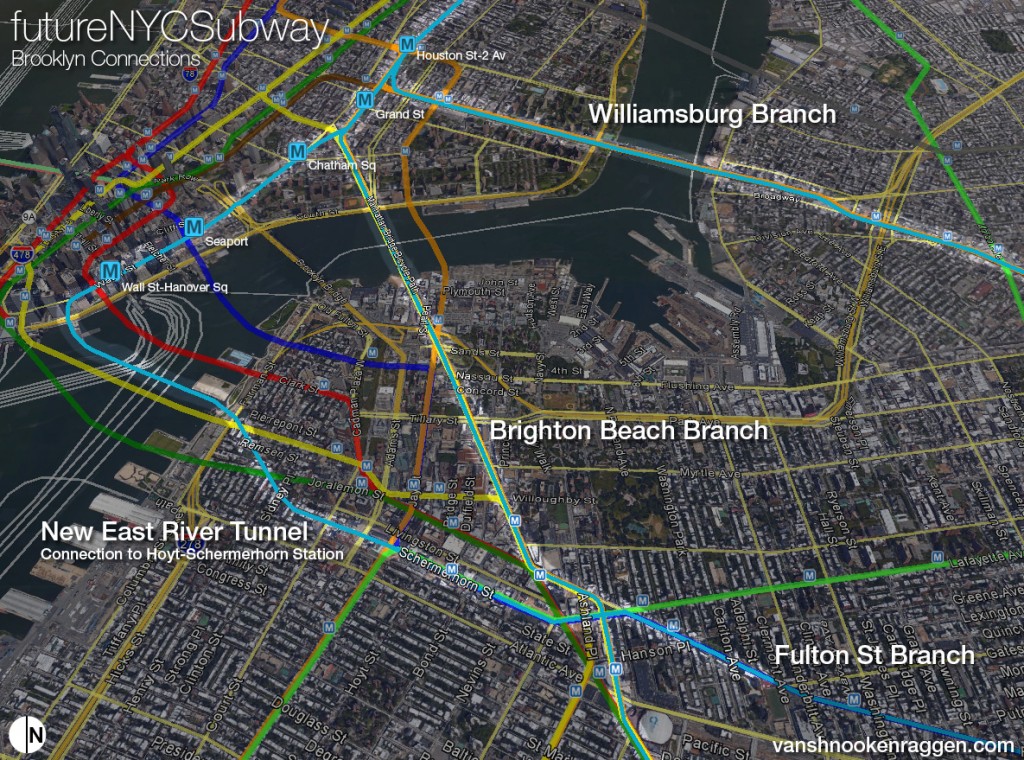
Capacity is a major problem with extending the 2nd Ave Subway into Brooklyn. DeKalb Station is a junction point between all the BMT trains in Brooklyn and one which can not handle additional traffic between trains running to Bay Ridge, Coney Island, and Brighton Beach. The only subway with extra capacity is the IND Fulton St Subway as only two trains run along it (and at night only the A runs). Furthermore with gentrification sweeping through Crown Heights and Bedford-Stuyvesant the need for more service along Fulton St will have only grown by the time the 2nd Ave Subway makes it to Phase 4. But having 2nd Ave trains running along Fulton St is only half of the equation. When the East Side Access project, set to open in late 2022, is up and running the MTA will no longer need to run Long Island Railroad trains to Atlantic Terminal. The current plan is to run a shuttle service form Atlantic Terminal to Jamaica but utilizing the Atlantic Ave ROW for an actual subway line is far more preferable.
In 2008 then MTA Chairman Elliott Sander made the case for expanding the 2nd Ave Subway into the outer boroughs and one such route was via the Atlantic Ave Branch. While this may seem like a good way to use the soon to be abandoned ROW there is one major hurdle: Atlantic Terminal itself. Right now at the intersection of Atlantic Ave and Flatbush Ave in Brooklyn runs two 4 track subways (2,3,4,5,N,R, D trains), one 2 track subway(B,Q trains), and an existing commuter rail terminal. If the 2nd Ave Subway is to be extended under Atlantic Ave to use the existing ROW it must first bury deep under Atlantic Terminal via a very expensive station which would need to support the existing infrastructure above. Then it must run to Jamaica making only a few stops at existing stations, or better yet at new stations along the line which are only two short blocks from stations along the existing IND Fulton St Subway. Yet again using an existing ROW doesn’t match up to the costs of upgrading it. Using the existing capacity along Fulton St is the cheapest option that offers the most service.
But that doesn’t mean the entire ROW should be abandoned. Running through East NY and Woodhaven, Queens the Atlantic Ave Branch runs through an area which isn’t as well served by existing express subways. The J/Z from Broadway Junction/East NY to Jamaica has no express track and runs a skip stop service at rush hour. The A/C trains running under Pitkin Ave are a half mile south of Atlantic Ave and run out to the Rockaways but not Jamaica. This means there is potential to run 2nd Ave trains along the stretch of Atlantic Ave from Broadway Junction to Jamaica. Where the IND Fulton St Subway curves south under Pennsylvania Ave two tracks would branch off of the local tracks and connect to the Atlantic Ave Branch. I would recommend as few infill stations as possible so that trains can act as an express line from Broadway Junction to Jamaica as the J/Z and A/C trains can cover existing local trips. New stations would be at Crescent St and Woodhaven Blvd. As there is capacity for two 2nd Ave services running along Fulton St one service can run to Jamaica (Archer Ave subway) and the other run out to Rockaway Park via a reopened Rockaway Branch Line (which would also connect to the IND Queens Blvd Subway). Woodhaven Blvd station would also act as a late night terminal for Rockaway Park trains, a service which would be a big improvement over the existing shuttle from Rockaway Park to Broad Channel.
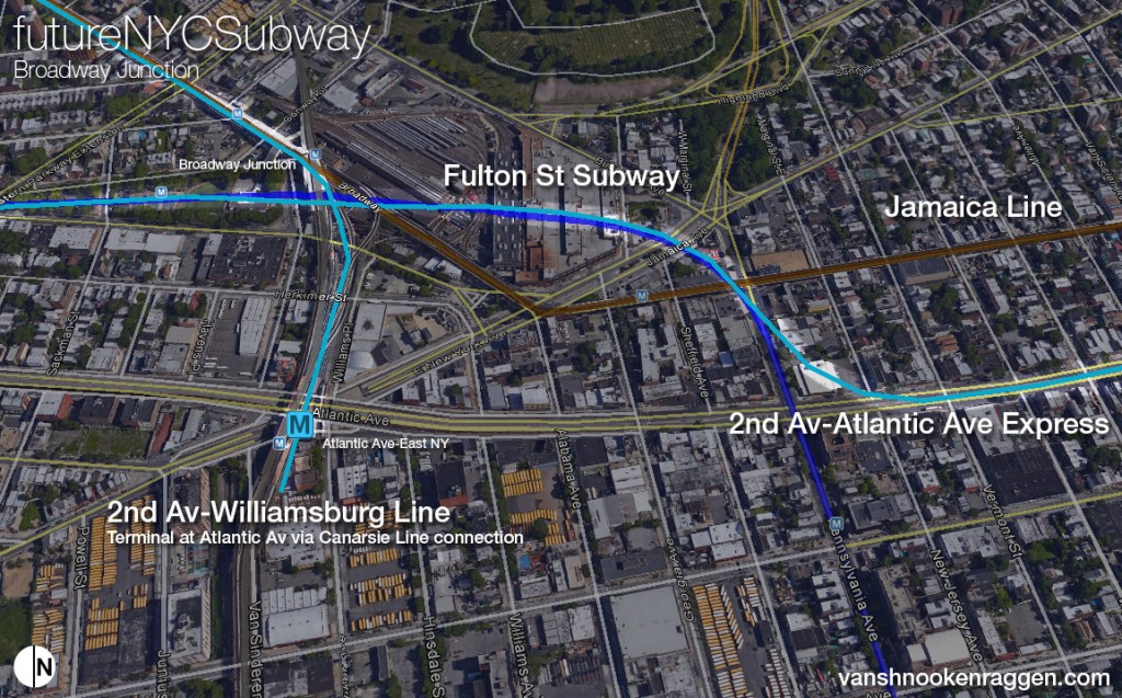
While this would be the main focus of 2nd Ave trains in Brooklyn having 4 tracks in Manhattan along 2nd Ave would mean that two additional trains could run which would best be used to utilize the Chrystie St Connection with one train running across the Williamsburg Bridge to Atlantic Ave-East NY (a service which once ran as the K train after the Chrystie St Connection opened) and another replacing the B train to Brighton Beach (more about the rerouted B train in the next section). Running 2nd Ave trains over the Williamsburg Bridge would help balance the load of new commuters from Bushwick and Bed-Stuy which currently use the L or M to get to Midtown or take the J and transfer. The J train and the BMT Centre St Subway in general suffer from being built when more people from northern Brooklyn were headed to lower Manhattan and the Financial District. Today commuting patterns have changed but the high cost of new infrastructure has hampered the ability to make needed service changes. Routing a branch of the 2nd Ave Subway along Broadway in Brooklyn would give commuters a quicker one seat ride to Midtown while still preserving the one seat ride to lower Manhattan.
Queens Service
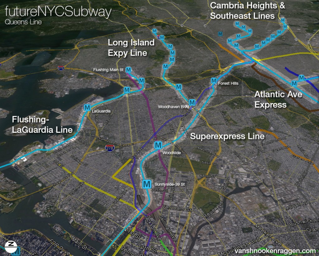
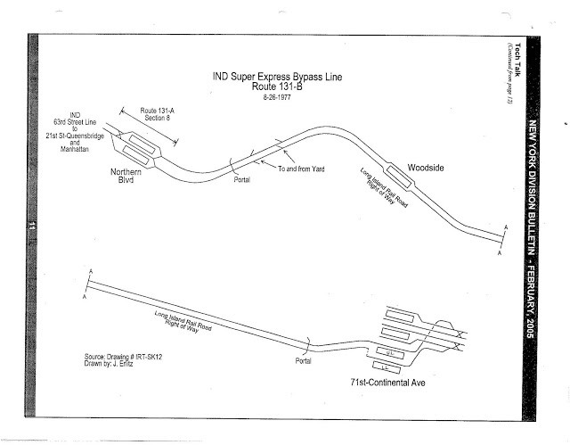
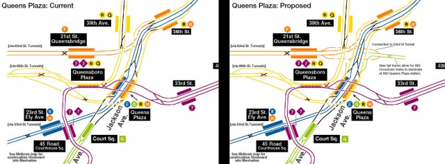
With 4 tracks along 2nd Ave two trains could be routed through the 63rd St tunnel to the proposed Superexpress Subway out to Forest Hills. Plans in the 1960s and 1970s also called for a branch off the Superexpress to run along the Long Island Expressway and I’ve incorporated this into the plan. As Robert Moses, who build the LIE, had little love of public transportation he left no room along his highways for future subway lines (as Chicago did with the Blue and Red Lines). This requires a subway along the frontage roads of the LIE (this was also how the Queens Blvd-Archer Ave Subway was built along side of the Van Wyck Expressway). The silver lining is that there are possibly fewer utilities to relocate along these frontage roads and constructing a tunnel along the highway will have less of a negative impact along the surrounding neighborhoods. The Archer Ave Subway through Jamaica Center was built to interface with the Superexpress Subway and future extensions were planned to Hollis, Queens and southeast along the LIRR Far Rockaway Branch to Laurelton. These extensions would be possible with a 2nd Ave-Superexpress Subway as existing lines don’t have the capacity for such extensions. Using the Atlantic Ave Branch the 2nd Ave trains would act as express lines to both downtown Brooklyn, lower Manhattan, and Midtown. Lastly, building the Superexpress means that G trains can be extended from Court Sq through Queens Plaza and terminate using tracks along the Superexpress line. Terminating G trains at Court Sq requires a labyrinthine transfer via two or more trains to continue into Queens so having the ability to run G trains through Queens Plaza station would ease transfers. This cannot be done presently due to the track layout north of Queens Plaza station but building the Superexpress line with an additional track connection to the IND Queens Blvd Subway would allow for such an extension of the G.
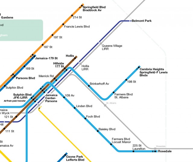
Southeastern Queens presents a transit problem when it comes to subways. The land has a high water table so tunnels are prone to flooding. Unlike in south Brooklyn there are no old railroads that could be converted into subway service and no ROWs were left for transit (the N, D, F, and Q trains all run along former steam railroad lines converted to subways by the 1920s); even highways were not built through southeast Queens but rather run on the periphery. The area is a largely residential and in dire need of better transit. Because of the distance from Manhattan any subway would need to run express through Brooklyn or Queens to keep commuting times low. While the LIRR does run through the area the higher fare costs and inflexible service patters dissuade many riders. The best option would be to extend subways along existing LIRR ROWs with as little tunneling as possible. The Southeast Line, as described above, would extend the Archer Ave Subway along the LIRR Far Rockaway Branch to Rosedale, totally converting the branch from LIRR to subway operations, and running it along the Superexpress Line. The second line would extend the Atlantic Ave Branch using the Archer Ave Subway to Hillside-177 St and then along the West Hempstead Branch until Linden Blvd where the line would tunnel just over a mile to Springfield Blvd. Additionally service on the J train would be extended to Hollis. New Select Bus Service routes could fill in the gaps so commuting from the edge of Queens can be as quick and seamless as possible.
Grand St Subway and Bushwick Express
After the 2nd Ave Subway the next area facing a congestion crisis is Williamsburg. Looking at a map of New York City you can see certain transit nodes where all lines from a borough intersect before entering Manhattan; Long Island City in Queens, downtown Brooklyn, and the area around 149th St in the Bronx. This was designed for flexibility in routing trains and so that riders could easily transfer to different lines outside of busy Midtown and Downtown transfer stations. In the 1930s Williamsburg was slated to be the 4th major transfer node so that riders from outer Brooklyn and southern Queens could bypass downtown Brooklyn and lower Manhattan. Plans were drawn up for the South 4th St Subway along with a 4 track Utica Ave and 4 track Myrtle Ave Subways. Collectively, along with the 2nd Ave Subway and other lesser extensions, this was known as the IND Second System. While provisions along the first phase of the IND were built for future expansion the Great Depression and high costs of the newly built IND lines killed this far reaching second phase. Then as northern and central Brooklyn began to depopulate in from the 1960s on the need for such an expansive subway vanished. What planners didn’t foresee was the transformation which Williamsburg, Bushwick, and Bed-Stuy have undergone since the 1990s and will continue to go through for the foreseeable future. Had the IND Utica Ave and IND Myrtle Ave Subways been built the L train today would not be so crowded for sure.
But that does not mean that we should dust off plans from 80 years ago as the growth throughout northern Brooklyn has not grown along the routes of these never built subways. The needs of today are based on what is here: the L, G, M, and J/Z trains all saw substantial ridership growth in the last decade and will continue to see growth as more people are pushed east by gentrification. In previous plans I tried to find a solution which would strike a balance between building subways to respond to current and future demand while taking into consideration the high costs of building what is essentially a totally new subway; the current subways in northern Brooklyn are only 2 or 3 tracks and cannot easily take on new extensions or express service. Furthermore the design flaws of the existing transfers limits the effectiveness of these subways.
Even with new 2nd Ave service on the BMT Jamaica Line through Williamsburg and Bed-Stuy a new tunnel further north will be needed to address the L train congestion. This new tunnel would run from the IND 6th Ave Subway at 2nd Ave under the East River to Grand St and Union Ave in Williamsburg. Here the line would split with one branch headed east under Grand St and making a long curve southeast to Flushing Ave where it would run parallel to the existing L train. The other branch would turn south and merge with the IND Crosstown Line between Metropolitan Ave and Broadway stations.
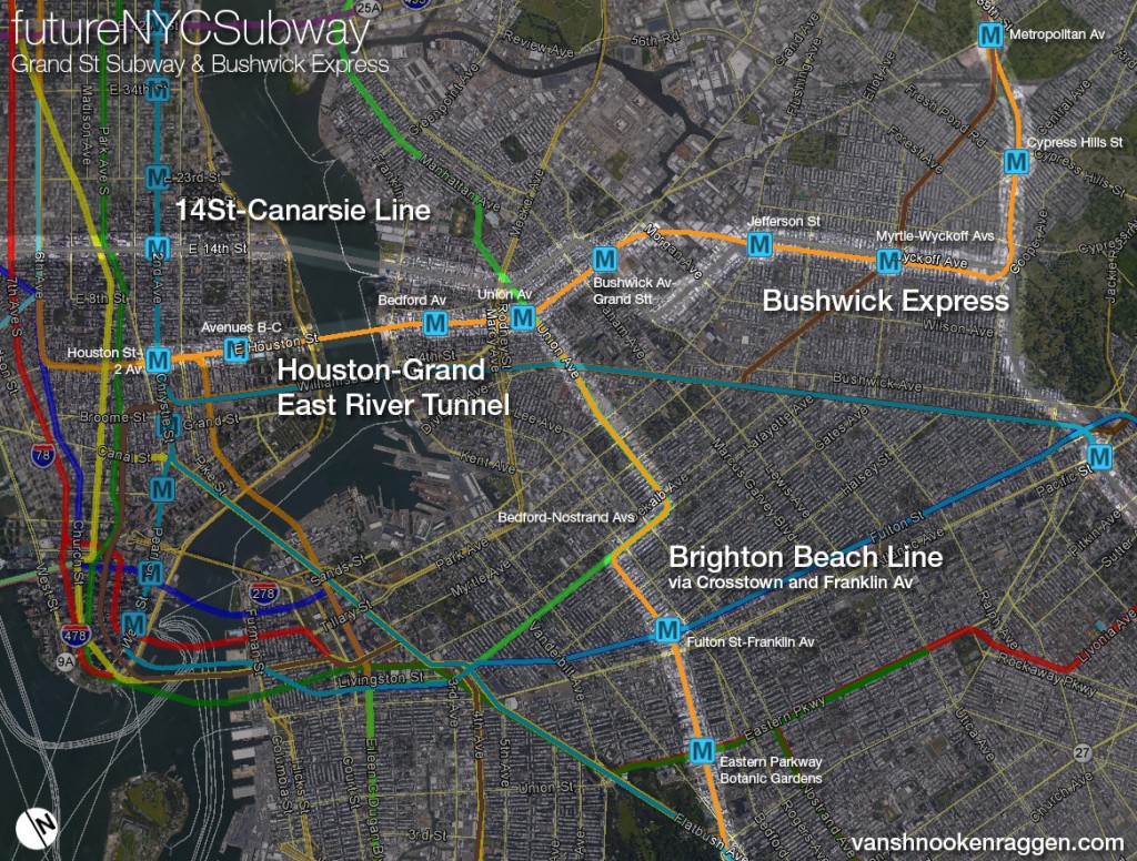
This first branch would be the Bushwick Express and act as an express counterpart to the L train through Bushwick. There would be stations at Grand, Jefferson, and Myrtle-Wyckoff. The new subway would require a deep bore tunnel under the English Kills section of Newtown Creek and then run along the ROW of the old Evergreen Branch RR. Because the Evergreen Branch was abandoned in the 1920s much of the ROW has been built up. However if you tour the ROW you will notice that much of what has been built is small garages/factories or parking lots. Only a few residential buildings are there and any displacement could easily be offset by air rights construction after the subway is built or offsite development. The new subway would continue southeast until after Halsey St where it would veer northeast to run along the ROW of the NY Connecting RR, the rail line that runs from Bay Ridge through Queens and over the Hell Gate Bridge. The subway would run along the existing track or below if the ROW needed to be rebuilt for passenger service (see IntraCity Rail below) and run through Middle Village to 57th Ave where it would run along the LIE to connect with the Superexpress-LIE branch I described above. As a further connection the line would then branch off the LIE under the interchange between the Van Wyck and Long Island Expressways headed north under the expressway to a new terminal at Flushing-Main St. The new line would connect the major nodes of central Queens, Queens Center Mall and Flushing, with northern Brooklyn and lower Manhattan and act as a collector for riders coming from central and eastern Queens to bypass Long Island City and Midtown.
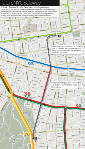
The second route which would merge with the IND Crosstown Line is an attempt replicate the utility of the IND Utica Ave Subway, acting as a bypass around downtown Brooklyn and lower Manhattan, but doing so by using as much existing infrastructure as possible. In my last two FNYCS proposals I introduced the Franklin Ave connection which would create a new crosstown subway using the Brighton Beach ROW and along the old Franklin Ave Shuttle. This crosstown route would finally connect the BMT Brighton Beach Line, the IRT Eastern Parkway Line, and the IND Fulton St Line to northern Brooklyn without having to first travel all the way to Atlantic Ave and transfer. Creating a true north-south subway through central Brooklyn would respond to a demand which has required the building of two separate Select Bus Service routes, one along Bedford-Nostrand Aves and a new one proposed for Utica Ave. I noticed that a large portion of riders using the L train between Manhattan and Brooklyn transfer at Lorimer St-Metropolitan Ave to grab the G train to head to Bed-Stuy. A new service which would be a one seat ride from Manhattan to Bed-Stuy along this corridor would take many riders off the L train. The need for a Utica Ave subway is still present (I address this below) so the question is whether a fully built out subway like that of the IND Second System is needed or a smaller version which connects just to the IRT Eastern Parkway Line would work. Because the need for the Utica Ave Subway is greater south of Eastern Parkway than it is between Williamsburg and Eastern Parkway (where subways already exist), this new service, which would be a rerouting of the B train along the IND Crosstown Line and new Franklin Ave Subway, would solve the problem of getting from southeastern Brooklyn to Midtown while at the same time increasing service to a growing section of the city.
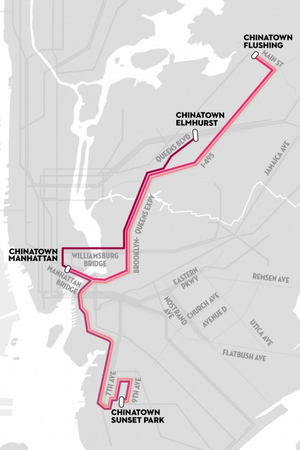
Because this new subway would need two trains from the IND 6th Ave Line this would mean rerouting the B and M along Houston St into Williamsburg. B trains would still run to Brighton Beach using the existing capacity along the Brighton Beach Line south of Prospect Park. The existing M train, the elevated Myrtle Ave Line, would be replaced by a rerouted Z train which would return to running to Broad St and possibly Sunset Park as the M train once did. With a connection to the Bushwick Express Line at Metropolitan Ave Z trains would continue north to Corona giving central Queens a one seat ride to lower Manhattan. This is a major benefit to the Bushwick Express concept as the line wouldn’t just take pressure off of the L train but also open up service through areas of Queens not currently served or areas that only have service to Midtown. In the New Yorker article “New York’s Shadow Transit” a major under the radar commuting corridor exists between Flushing, Chinatown, and Sunset Park; the three Chinatowns of NYC. This expanded Z train would connect all three with a one seat ride.
South Bronx Airport Center
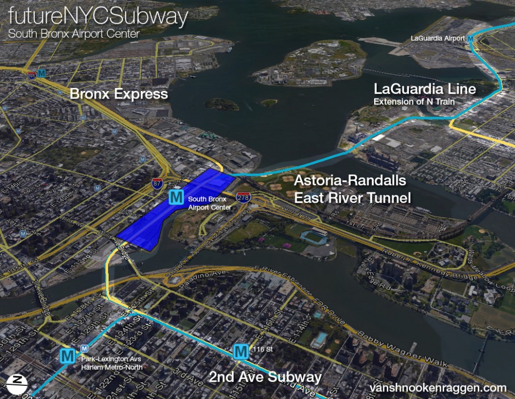
The South Bronx Airport Center has less to do with subway expansion by itself but rather a way to incorporate subway expansion into a new urban system. In version 3 of the FNYCS I designed a subway shuttle service using the Cross-Harlem Line running through Randalls Island into Astoria and on to LaGuardia Airport. That was before I was inspired by the ReThinkNYC proposal by Jim Venturi. As part of the ReThinkNYC proposal Rikers Island will be depopulated of its infamous prison and new terminal facilities for LaGuardia Airport will be built there. Right across the East River in Port Morris, Bronx, a major rail terminal and mini-city will be built which will connect rail travelers coming from New England, Upstate NY, and New Jersey. It is a truly revolutionary proposal; an idea with a lot of broad strokes, high ideals and an unimaginable cost so I began to wonder about a stripped down version which would be more affordable.
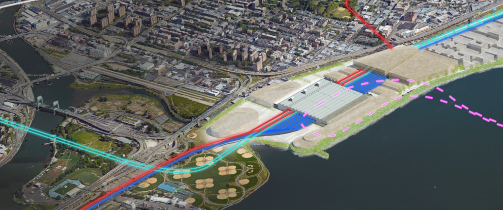
The brilliance of the ReThinkNYC plan is using land in the Bronx for airport check-in facilities since there isn’t much room for expansion at the current airport. Building these new facilities where subways, intercity trains, and highways meet reduces traffic and the need for so many transfers. But instead of redeveloping all of Port Morris it would be cheaper to use the vacant land bordered by the Harlem River, Bronx Kill, and E 132nd St. This section of land also happens to be through where the 2nd Ave-Dyre Ave Line would run and a new station along the Metro-North/Northeastern Corridor tracks along the Bronx approach of the Hell Gate Bridge would form the basic transit connection. Because the area is at the beginning of the Bruckner Expressway either existing city streets could be expanded for the additional traffic or new ramps built which would serve intercity buses. The ReThinkNYC proposal is more about making the current commuter rail network, which terminates in Manhattan, into an intercity, through-running network which would offer one seat rides from New Jersey to Connecticut. I am more focused on the subway aspect and I think that an airport terminal here would work even without a radical rethinking of the regions rail system.
The first level would be train yards for the 2nd Ave Subway. Above that would be a large parking garage. The central section of the new project would be an off site (of the airport) check-in facility where bags are checked and tickets purchased. Centralizing as much of the passenger infrastructure here would reduce traffic on the RFK-Triboro Bridge or Bronx-Whitestone Bridge. Additional sections of the center would have hotels, retail, and possibly affordable housing. As the massive new development would cut off the South Bronx from the waterfront (not that it isn’t already cut off) there would be a large new pedestrian bridge over the Bronx Kill connecting Bruckner Blvd with the parks of Randalls Island.
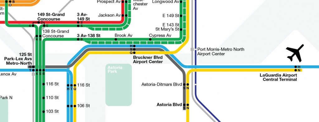
A new subway from the Airport Center to LaGuardia via Astoria would run four services: a branch of the 2nd Ave Subway to LaGuardia, a subway shuttle from the Metro-North station at Harlem-125th St to Astoria Blvd, and a baggage transportation system so that passengers bags can be transported directly to their proper terminals (to clarify the baggage “subway” would be completely separate from the passenger subway). Once in Queens there would also be a connection to the N train, extended from Astoria-Ditmars Blvd. The number of stations would depend on the redesign of the LaGuardia Terminals. Because LaGuardia is right next to a dense urban neighborhood these stations would also be heavily used by non-airport bound commuters. The subway would then extend past LaGuardia and run along the Grand Central Parkway to Mets-Willets Point along the route proposed by Gov Andrew Cuomo for the new AirTrain. The subway would then terminate at Flushing-Main St. Anyone going to the airport can now reach it via Manhattan, the Bronx, or Queens while regular commuters from Flushing and northern Queens will use it to bypass Long Island City and Midtown while commuting to upper Manhattan and the Bronx. Building only an AirTrain, which would cost an additional fee for subway riders, would only serve the airport. Expanding the subway network through the airport along with a new connection to the Bronx has more value and thus worth the extra cost.
Utica and Nostrand Ave Extensions
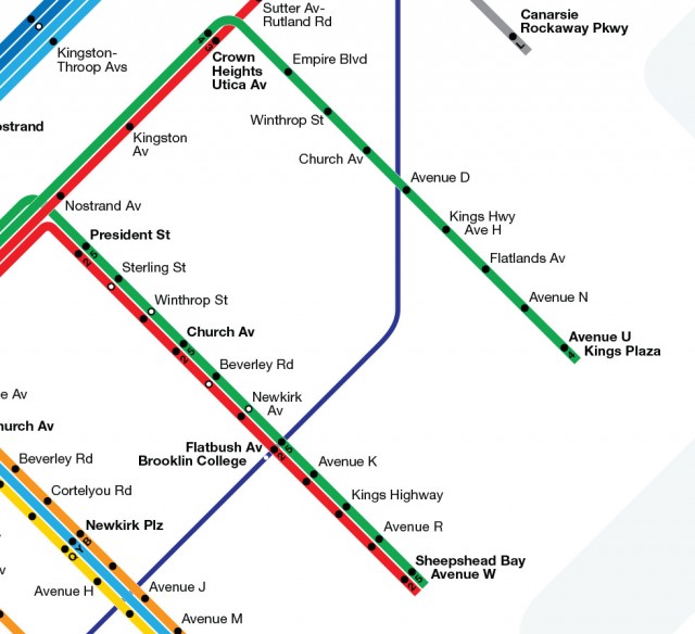
The need for subway service to southeastern Brooklyn got renewed interest when Mayor de Blasio recently come out in favor of building the Utica Ave Subway. No details have come forth so it may be just another fluff piece from City Hall. Regardless, a 2 track subway extending the 4 train south of Eastern Parkway is the only logical option. As I explained above building the Utica Ave Subway through Williamsburg, the IND Second System plan, would double the cost and scope of the project and have to spend too much of the construction building subways through areas that already have subways (Williamsburg, Bushwick, and Bed-Stuy). The need is greatest south of Eastern Parkway and though there are issues with capacity as the IRT Eastern Parkway branches get closer to downtown Brooklyn I think that having the Franklin Ave Subway acting as a bypass would mitigate any capacity issues.
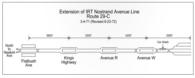
Additionally the Nostrand Ave Subway should be extended south to Sheepshead Bay. I have included a new skip-stop service along the line to speed travel times, though it would have to be studied to know the effectiveness of such service.
Queens Extensions
Rockaway Branch
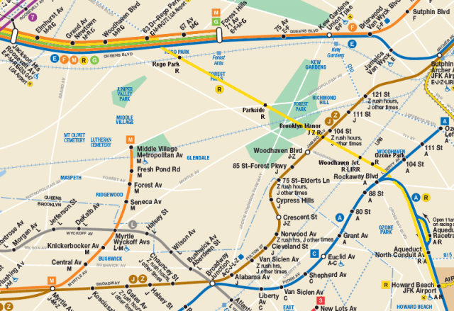
Reactivating the abandoned LIRR Rockaway Branch, connecting Queens Blvd trains to Howard Beach-JFK, is possibly the best transit expansion for the least amount of money the city could build. The biggest issue is the neighboring residential communities which have enjoyed a quiet existence next to the abandoned ROW for 50 years. The benefits to the city, and even to these neighbors, would outweigh the inconvenience. When the IND Queens Blvd Subway was built provisions along the tunnel were left to extend local trains south after 63 Dr-Rego Park. Further studies should be done to find the best placement for stations but the original stations at Parkside-Metropolitan Ave, Jamaica Ave, Atlantic Ave, and 103 Ave could be rebuilt. Because the only way to incorporate this new service into the Queens Blvd Subway is via a local train, most likely the R, it may be a worthwhile investment to convert Woodhaven Blvd station to an express station. Incorporating the Superexpress into the Rockaway Branch may also work but given how far off the Superexpress is from being built finding a solution via the Queens Blvd Subway is the only viable option.
Hillside Ave Extension

Extending the Hillside Ave subway in Jamaica should be included in any long range plan. Again, extending subway tunnels may be prohibitively expensive this far out in Queens so this is would be a low priority. This is a corridor which would benefit from a Select Bus Service to determine any future needs for subway construction.
Flushing Expansion
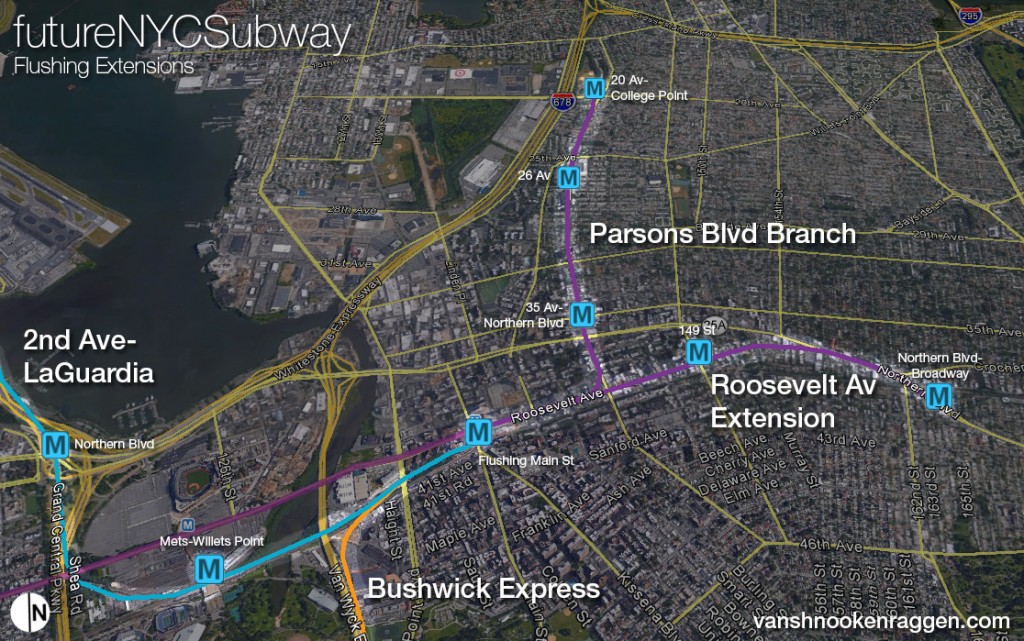
Flushing is in dire need of improved subway transportation. In proposals above I’ve outlined how the 2nd Ave Subway could be extended out this way via LaGuardia and how the Bushwick Express could give Flushing residents a one seat ride to lower Manhattan via central Queens and Williamsburg. The two most important corridors for new service are down Roosevelt Ave to Northern Blvd and north under Parsons Blvd or 149 St. The only way to do this is via tunneling. The 7 train is seeing continued growth and with the introduction of CBCT signalling it will be able to run more trains. What I’m proposing is splitting the service between a 7 train and an 8 train. Because the line only has 3 tracks express service would run at rush hour, as it does now. Two branches would fill in these corridors and sop up commuters who normally would make a transfer from bus routes at Flushing-Main St, a station never designed to handle the traffic it sees. A new terminal station for 2nd Ave and Bushwick trains would shoulder the burden and distribute commuters away from the congested Roosevelt Ave corridor through Corona and Jackson Heights.
Manhattan and Bronx Extensions
10th Ave Subway
A 2 track line, extending the L train at 14th St and 8th Ave to 72nd St and Amsterdam Ave will be required after 20 years of development throughout the west side of Manhattan overloads the 2/3 and 7 trains currently at capacity. Nothing about this has changed from version 3 except it the subway may be built with 3 tracks in sections for extra train storage.
North Riverdale Extensions
I’ve never known why the 1 train had never been extended north to the border of Yonkers but when someone asked about Riverdale I realized that the 1 train could use an extension. I’ve also brought back the 9 train for rush hour skip-stop service since I believe that once the Hudson Yards and World Trade Center are both built and open the need for better service on the west side will warrant additional local service (9).
IND Concourse Line Extension
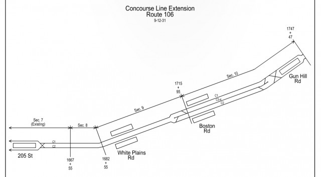
Extending the IND Concourse Line east to Coop City would kill two birds with one stone as it would finally bring a subway to Coop City and also create a de facto crosstown subway which would allow commuters to bypass congested parts of the Lexington Ave Subway and its Bronx branches.
IntraCity Rail
I’ve written in the past how I never saw the RPA’s proposal for a circumferential transit line, dubbed Triboro RX, worth the cost. While it has high ideals the fact is the ROW doesn’t really run anywhere people need to commute to. As the original railroad lines on which it is based never saw passenger service (except in small sections like through East New York) most subways don’t stop for easy transfers. This makes the concept less than ideal.
But looking at the line by itself might be short sighted. Cities in Europe are finding innovative ways to use their existing train lines by creating hybrid commuter rail transit systems. The S-Bahn in Berlin, the RER in Paris, and the Overground in London have all revolutionized how these commuter rail lines work. These hybrid lines also integrate with the subway as much as possible and costs are in line with subway prices rather than a destination based fare system. Transfers can be made via smart passes so station costs can be kept low.
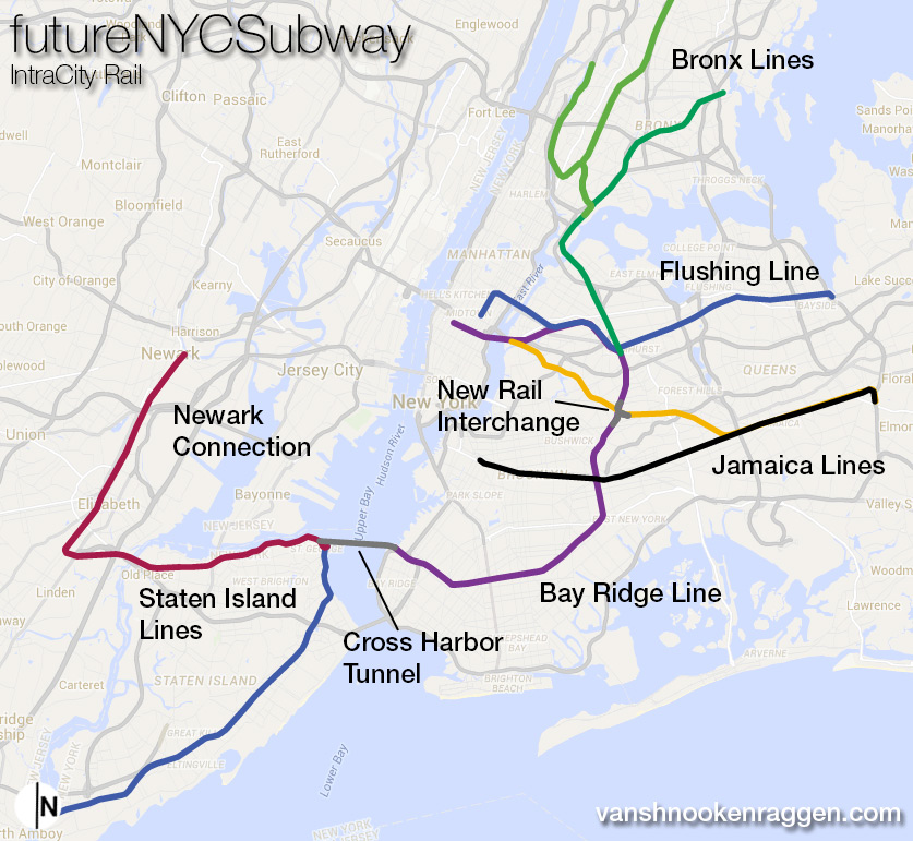
The idea behind the IntraCity Line is that you take the existing radial commuter rail routes of the LIRR and Metro-North and connect them via existing rail ROWs that are currently lightly used for freight. The map I have designed does not provide any routes set in stone as it would take a large study to determine which routes would make the most sense. But by building new connections in Queens and the Bronx a commuter from Long Island could get to Westchester without having to change in Midtown or drive over the congested East River bridges. If the Cross Harbor Freight Tunnel is finally constructed then the Staten Island RR could be extended directly to Grand Central or Penn Station. Now the three regional airports are all connected to rail lines that serve the entire region rather than only Long Island or New Jersey.
Granted the majority of trips in the New York region area headed to Manhattan. But there is still a need for trips that go to other centers, Flushing, Jamaica, the South Bronx, and Staten Island. While these are not major commercial districts like Midtown they are major sub centers within the city and connecting them to a more flexible network of trains would open up job centers outside of Manhattan. New auto bridges and highways won’t be built in New York City they way there were in the 20th Century so the only way to reduce traffic is through innovative uses of the infrastructure we have. Anyone who doesn’t commute into Manhattan needs to travel around the city and they only option for many is to drive.
The IntraCity concept won’t be cheap and may well be on the same scope, cost wise, as a fully built 2nd Ave Subway or East Side Access. But the new network would open up so much new economic growth possibilities at the same time as reducing congestion on transit lines and highways around the region that it may well be worth more to build than it would to build small, piecemeal subways and highways that only address small areas of congestion. Additionally there is climate change to consider; Hurricane Sandy showed the economic impact that blocking existing transit tunnels does to the city so having a back up route that can still connect commuters by bypassing closed tunnels can keep the city running during times of crisis.
Conclusion
As always these ideas are fun to fantasize about but what really matters is money. If you read the history of subways in New York you see the same thing over and over again; to get anything built you need a powerful politician who wants to get it done. If it wasn’t for John Hylan we wouldn’t have the A train (also the B,C,D,E,F & G trains). LaGuardia ripped the Els down but it was Robert Moses who built highways instead. Rockefeller knocked Moses out of power by creating the MTA which used the Triboro Bridge and Tunnel funds to upgrade the aging system. Michael Bloomberg wanted a subway for his real estate pals and later this year the 7 Train extension to Hudson Yards is set to open. Our current Governor is, unfortunately, no friend of transit and while Mayor Bill de Blasio has supported transit expansion he has yet to put his money where his mouth is.
The New York City Subway needs to be lead by people who don’t remember the bad days of the 1970s and 80s when ridership plummeted. New York is a different place now and this is reflected by the highest subway ridership numbers ever. We need politicians who look to the future. The city has for too long only seen the subway as something it had to patch up and keep running. There hasn’t been a serious wide ranging transportation plan for the city since 1968 and it’s time for the city to take hard look at what it will take to keep the city growing and keep it affordable.
Obviously just building subways will not be enough. In this version of the FNYCS I introduced a sketch of an idea for IntraCity rail but the truth is what is really needed is a more balanced system. Many of the lines I’ve proposed can’t even be built until other projects (2nd Ave, East Side Access) are built first so it’s worth considering adding new Select Service, BRT, routes throughout the outer boroughs to gauge the future need of many of these corridors. Ferry service too can help, though this is limited to new developments along the water. This brings up the issue of climate change and how the city and subway needs to adapt for sea level rise and future storms. Building a future transportation network which has redundancies built in and encourages new development away from low lying areas will soften the impact of future disasters.
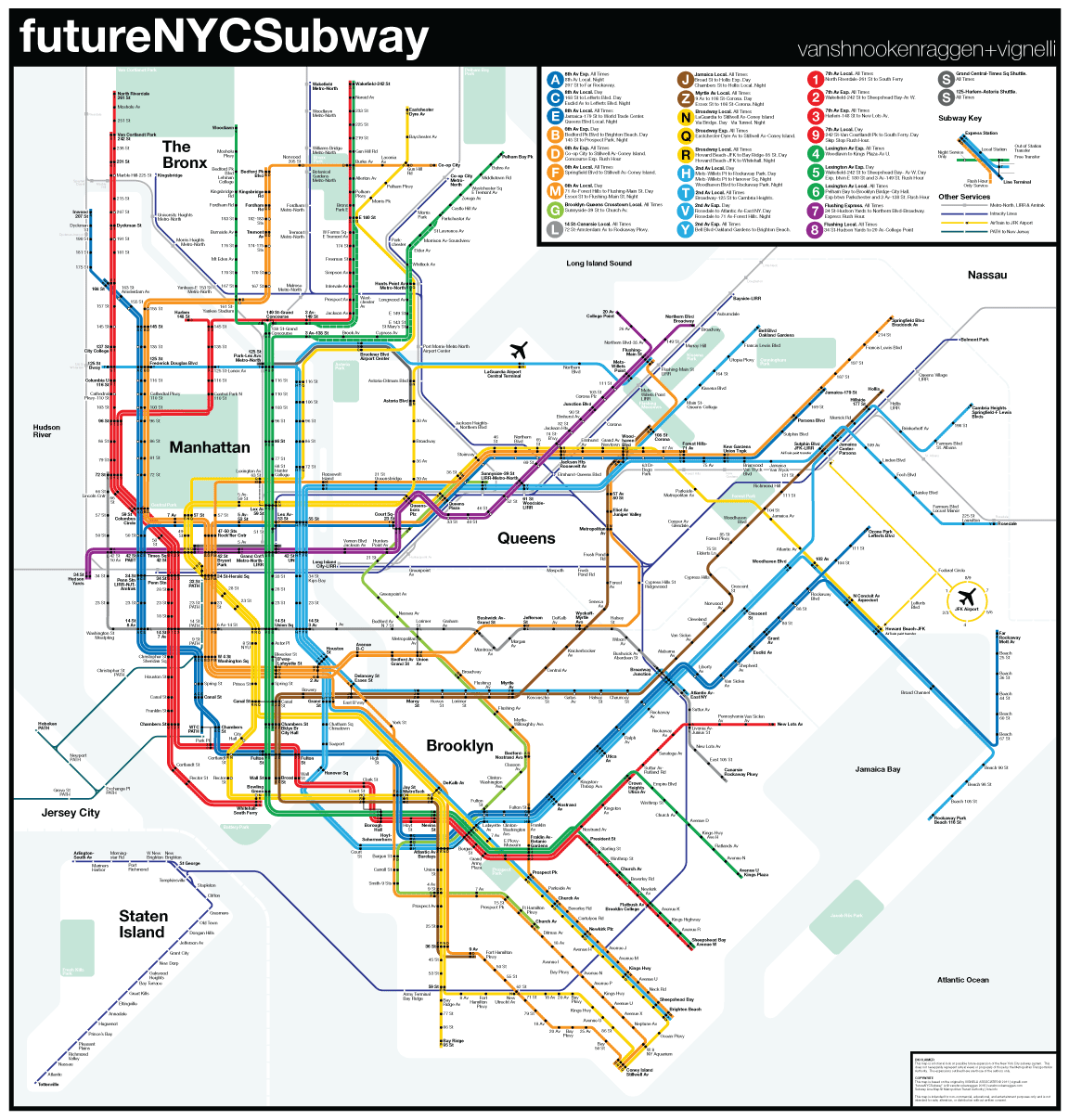
On a really nerdy cartographic note I want to add that I think I found a good way to integrate the different subway and rail systems in the region into one map. I also added a key showing the routes of each train and how it would run, as well as a visual key for reading the map (FNYCS v1 had this but not v2 or v3). Since I last drew a FNYCS map the man who inspired this map, Massimo Vignelli, passed away and I want to thank him for his amazing work. I use his map as a tribute to him and also because it offers visual clarity which I am constantly trying to honor. It’s hard to change and expand the map so much, adding so much new information, and still keep it easy to read. The fact that he created a system that can so easily and cleanly be expanded upon speaks to his genius.
As always I welcome a constructive discussion of my ideas and if you spot any errors please let me know.

Is there any particular reason why your RX has a terminus at Kingsbridge instead of Marble Hill to connect with the (1)? Also, why Gun Hill instead of the recent proposal to bring the A across Pelham Pkwy?
Marble Hill can’t act as a proper terminal as there is no space for a layup track. I suppose, though, that if a new Marble Hill station was built on the east side of Broadway it could be built with a terminal track. Routing the A via Pelham Bay Parkway requires some costly tunneling under the Harlem River and through very strong rock through University and Fordham Heights. The grade to get from Inwood up to Fordham is very steep and would require tunneling through 2 of the city’s water tunnels. Tunneling under Burke Ave and Gun Hill Rd would be much cheaper and the tunnel much shorter in comparison. The same crosstown service is achieved since the D and A meet up at 145th St in Manhattan. Anyone still needing to get from the eastern Bronx to Inwood or Washington Heights would still see an improvement in their commute as they can take the D and change at Fordham Rd for the bus.
HI,
I’m a student and I’m working on a school project on how to create a modified version of the current NYC subway to accommodate the needs of New Yorkers in 2015. Your work has really inspired me, not only to take on this project, but to actually consider many of these things. I feel like this new version is pretty good although I have a few ideas.
However unoriginal they may seem, just throwing them out there.
Rather than extending the 4 down Utica Avenue, I was thinking a better alternative would be the J, or Z. This would connect the Jamaica line to both, the Fulton, and Eastern Parkway. This would provide slightly easier transfers and commutes.
Another thing, the shuttle you had in one of your posts in something I really think was a good idea. I don’t exactly remember where it went, but I believe it traveled between Jamaica Center-Parsons and Mets-Willets Point. This was a good idea, and with this new La Guardia airport center in the Bronx, it would be really convienent if it connected both Jamaica and the new airport center.
One more thing, as I wanted to also start creating my own digital subway maps, are there any certain websites/applications that you would suggest to use? Or how do I create this style of map?
CD
Clyde,
Extending the J or Z is a non starter firstly because it would have to be elevated, second the terrain between Fulton St and Empire Blvd is a bit steep for an elevated train which would have to soar pretty high up to jump over the elevated LIRR tracks on Atlantic, third there isn’t capacity along the line to add a branch that wouldn’t negatively impact headways from Boadway Junction to Jamaica.
The shuttle idea is one that could still work within the new version by adding a few miles of track along the Van Wyck Expressway. It’s worth studying to see if there is enough of a demand, though given that the line would run mostly along park land or cemeteries I doubt the ridership would be there to justify the cost. A Select Bus line along Main St would be a good first step and it could even be extended along the Grand Central Parkway to connect Jamaica, Flushing and LaGuardia. If that proved popular enough then rails could be added.
I use a combination of things but mostly I use Google Maps to sketch out my ideas. Then for the final maps I make them in Adobe Illustrator and some finishing touches in Photoshop.
Good luck!
Your ideas are brilliant, but like Rethink NYC, I think its all far too much and quite frankly unrealistic. To put this in perspective, I’ve shown many people my future map which is far more conservative than yours and most who see my map think I’m crazy, lol. Nevertheless, I’m very passionate about the NYC subway system, but I believe the only way to reshape the current system is to come up with proposals that are realistic and feasible. Still, this is great stuff. I’ve attached a link to my map at the bottom.
https://drive.google.com/file/d/0B4cdJBZQ7y80Y1BvUFlTZl9KMnc/view?usp=sharing
Hi Steven,
Thanks for sending this along. I try to keep my ideas withing the realm of possibility by acknowledging costs. This most recent map I built off of a few previous proposals and updated them for current needs. Obviously many of the proposals are far out, I think I even said somewhere that most can’t even be considered until the 2nd Ave Subway is fully built. It’s easy to laugh it off but if you dig into what I’m proposing nothing is that crazy or impossible. It’s all about priorities.
Taking a look at your map I noticed a few things that would straight up not work, but not for lack of funds. Your service in the Bronx seems to be reshuffling the deck but not making things much better. The heavy demand is on the 2/5 and 6 lines but sending the 5 up to Moshulu Parkway (where it can’t terminate due to track layout) and sending the 3 to Dyre Ave doesn’t make a whole lot of sense given current demand and tack capacity. Having the 1 terminate at 148th St would mean reducing service on the 1,2 and 3 lines in order to get that to fit. Also the train widths of the 6 and the T trains are different and since there are only 3 tracks along the Pelham Line it wouldn’t work to send the T up there. There was a historical plan to send the 2nd Ave Subway up the Pelham Line but this would have also cut the 6 back to 138th or Hunts Point Av. It makes much more sense to send the T (or Q) to Dyre Ave and act as an express train to siphon off riders from the central Bronx.
Also there are going to be some problems in central Queens along the Queens Blvd Line and the 7. The 8 train you have to Middle Village would have to be elevated and the interlocking with the 7 at grade which would cause massive backups on the 7 right where it is most congested today. On the Queens Blvd Line you’ve brought back the G but the issue is still congestion. The G can’t fit except for late at night when it is most useless. There is a reason the MTA cut it back decades ago. Building the Superexpress Line to Forest Hills would not just add capacity along the Queens Blvd Line but also bring the 2nd Ave Subway and 63rd St Tunnel up to full capacity. This is what allows new routes to be built further into Jamaica or Flushing. Even as built as a 2 track line the 2nd Ave Subway can have another service between Hanover Sq and 63rd St.
In Brooklyn I’ve got some issues with the F going full express. The MTA did a study on reviving express trains along the F and found that the greatest passenger growth was between Jay St and Church Av so having the F skip all that wouldn’t make sense. I think a good trade off should be a rush hour express that makes express stops to Kings Highway. You’ve brought back the W train to go to Staten Island which is cool but the issue there is that it shares track with the N through DeKalb St where there isn’t any additional capacity. The Z could work but what would benefit Staten Island riders most is a one seat ride to Midtown so having the W run through the Montague St Tunnel would resolve both those issues.
The 9 train down the West Side is a great idea and if the city had been more forward thinking it might have saved the High Line for such a purpose. Alas the powers that be have not kept up with the transportation needs of the city.
Thanks for sending this along and keep making maps!
Thanks for the feedback. Your critiques are valid and yes anything is possible. If you can conceive it it can happen. If the powers that be wanted, a tunnel from south ferry to St George could be built. Yes, that would be a massive undertaking but anything is possible if you have the resources and will. However, aside from sins some additions, I try to come up with ideas that could work within the system. I think my reshuffling of the Bronx could work, heck it couldn’t make things worse. If the MTA invested in a legitimate signal system or even modern a train tracking system, I feel most of the congestion issues you brought up would be solved. Of course, you can account for sick passengers or as the MTA likes to say “unruly passengers” holding train doors. Anywho, I’m glad I’m not the only one making “crazy maps.” Nice to see forum where ppl are discussing the transit system. Very cool.
Hello,
I love your maps. Especially what you’ve done in the Bronx and also the Harlem 125th st cross town line (gosh, that would be a dream come true). I feel like the Bronx is so unfortunately neglected when it comes to subways and it really reflects in service.
I did want to propose some ideas, though. I’m a complete amateur so I have no idea about costs etc, I just know what would feel convenient. I agree that Co-op city desperately needs subway access, however, could this be more easily achieved through extension of the 6 line? It seems like it would just need to have a bridge built over I95 and end at bartow avenue, or somewhere within coop city. plus it’s only one mile away.
fitting my idea within your map, it could also allow for transfer to the D!
As someone who’s ridden the 6 since forever, there is something very annoying and peculiar about it that anyone else who knows it can confirm. we all groan when it does this, each and every time. It creeps it’s way up to around middletown rd, and then to buhre, then after buhre, just when you think you’re almost there, it stops for a good 5 to sometimes TEN minutes to wait for the other train to pull out of pelham bay. obviously this occurs in all terminal stops, but i have experienced it far worse at pelham bay for whatever reason. perhaps moving the terminus to coop city could also allow for more rails to be put there (above one of the malls/stores?) to avoid congestion at the terminus and to have the trains keep flowing.
also, having the 6 train run express from pelham bay to parkchester would be ideal as well. if you look at the 7 express, it has three loops through queens. the 6 can be the same. as someone who rides this during rush hour I can tell you soooo few people seem to get on between pelham bay and parkchester. there can just be a concurrent local service. at the most, i think there can be a stop at westchester square.
thanks for fueling our subway fantasies with these maps!
Alex, Thanks so much for the feedback. I’m not personally familiar with this section of the Bronx so it helps to have some on the ground feedback. I’ll work on this for the next release.
I love your maps. I’m curious as to why you got rid of your 86th Street crosstown service into Queens (as an extension of the 10th Avenue L) which you had in version 3. No real demand, or would the cost be prohibitive?
I think I took it out to trim costs. I don’t know the true costs of these ideas but any time I can condense ideas to shave costs I think it helps. These are all just thought experiments but ones that could offer some real world solutions so I like to at least try to frame them withing the financial bounds of reality.
Hi, Van
I’ve been an avid reviewer of the website, especially the future NYCsubway pages. You’ve definitively went beyond the lines I once drew in my Hagstrom atlas. Question why haven’t you consider some of the third tracks that aren’t used on the 1, 4, N, D and F lines. if CBTC is installed do you think they can be re-activated I remeber when they used the 4 train to experiment on putting on limited express service. It might not have worked about 8 years ago but as more people move back to the Bronx and S. Brooklyn the need to increase service will come to the forefront. I mean take a look at the F line in South Slope. Also I liked the idea in the first version of the C line to New Jersey and L wrapping around to the Upper East Side.
Once again love the ideas!
Hi Aj,
Thanks for the feedback. Using the 3rd track is something I play with now and then. It really depends on the ridership needs. For instance the 4 train has seen a drop in ridership on almost every station in the Bronx so adding and express train might not be worth the extra cost. On the other hand the N train really needs the W to come back and having rush hour express would be a big improvement. I think this is in the cards once the Q is routed along 2nd Ave in a few years. The big problem with a lot of these third tracks is that the ends of the lines aren’t usually busy enough to require express service or that the stations skipped are ones in need of better service. The F, for example, is pretty close to the D, N, and Q trains once it passes Kings Highway so having an express train doesn’t help that many people. The F has seen the biggest ridership increases between Jay St and Church Av so adding an express train there would only bypass the customers that need it most. Same for the other end along Queens Blvd. However if these lines were extended then utilizing the express tracks should be looked at.
I’m excited about several things on this new map, and have several questions:
1) 125th St Crosstown:
Instead of running to 125th and Broadway, can the T instead merge with the 8th avenue around 135th and St Nick? The 8th ave line at 135 is 6 tracks wide. If the T was sent up with the A (local to 168 or express to 207) it would have access to the yard at 207, and the 1 transfer at 168. I don’t fully understand the interlocking south of 145 (or the BD service pattern at 145, for that matter), so it’s a little hard to tell if “plugging the T in” on the unused tracks at 135 will work gracefully to merge the T with the A or C. Offhand I’d imagine that the complexity of doing this would be similar to the addition of the 63rd st F service north of Queens Plaza (Underpinning a currently complex interlockign, and figuring service patterns that don’t conflict within the interlocking). Certainly things are helped by the existing interlocking being an IND, and not having something sparse like Rogers or 96th St IRT, I.e. there’s plenty of space and additional service pattern provisions built in already. It’s possible there’s some inefficiency doing the AT+C+B+D AD+BC+T recombine, though again Queens Plaza manages to do something similarly complex (EF+RM+NQ EM+NQR+F) without too much trouble.
2) E -> Montague -> Culver local
In looking at other “small” connections, I’m curious if you’ve ever thought about a connection between the E’s terminus at WTC and the BMT Tracks down Church st. Someone at the NYCTransit Fourms seems to think these tracks are at the same height (the R and the E). The uptown local tracks would need a flying junction, for which there might not be enough room, but if there is, this gives IND use of the BMT Montague Tunnel which opens up some possibilities for interesting service patterns.
I’ve always thoguht of the E->R connection as paired with another connection: a connection between the Montague tunnel and the giant IND junction at Smith and Schermerhorn. Both the F and AC leave this junction to 4 track mainlines, but significantly less than 4 track mainline levels of service. Plugging the Montague here might be cheaper than building a new tunnel connection the T to Court St. I don’t now how the 2345 and R interact around Borough Hall, but I think the R is much deeper. If a connection from the R could run down Boerum and turn down Livingston or Schermerhorn (at the NYCT building) it could be plugged into the AC or F system. Combined with the E->R connection in manhattan, you could open up F express service with the construction of like 1000 feet of track (traded off for significant junction work, so who knows how expensive that could be). The service pattern could be similar to the BD plan north of 59th st (Late Night: F local to Coney, E local to WTC; Off Peak: F local Coney to Church, express to Jay, E Local to church via Montague; Peak: F Local Coney to Kings hwy, peak direction express to Jay, E local to Coney?? (you might have to build kings hwy or ave x as a terminal similar to Bedford Park Blvd and run your locals to this).
This would also give you the flexibility to reshuffle some BMT or IND services in brooklyn if crowding called for it (a la Christie St Connection).
3) The Port Morris Branch
I’m pretty excited whenever someone rediscovers the Port Morris ROW. I’ve always thought that this ROW would be well suited to conversion as a Harlem line alternate route to Manhattan (i.e. Penn Station instead of GCT) if a connection was made to the Hell Gate Viaduct. This would let all three Metro-North lines run even if the 135th St Bridge was out, or the Park Ave tunnel needed work. But I’m curious if you have any more information about the dimensions of the ROW and how they might constrain double-track rail operations. I have heard that the tunnel under St Marys Park is too narrow for long cars to pass eachother, and having looked at the tunnel myself I’d believe it. I’d think that in the wake of Sandy, and the renewed focus on operational redundancy and flexibility, there might be more focus on adding in connections like this, but I suppose we’ll see.
Hi Rob,
Thanks for the great feedback.
1) I have considered this connection but the issue I see is that the junction would have to be between 125 and 135 St stations which means that the T line would need to somehow make its way north from 125 St and a block over to interface with the 8th Ave subway. I’ve looked at various different ways this could be done, all of them complicated and expensive. I think that in the end just keeping the lines separate and having a simple station to station transfer would be the most economical option. Keeping the lines separate also avoids complications with disabled trains or emergencies. There are a lot of places in the system that look like easy connections but end up being more complicated than they are worth. Besides, with Columbia expanding west of Broadway it would make more sense to just extend the T to Broadway-125th. I have no idea where the MTA is planning on putting the 2nd Ave subway yards but there are a couple options so connecting the T to the A doesn’t really matter. Also I’m sure the A train yards at 207th are pretty full so it would be a meaningless connection.
2)I know this connection has been considered in the past as I’ve seen the maps (I wish I had saved them!) If you look in a lot of my plans you’ll see I use the connection you are talking about between Court St (R) and Hoyt-Schermerhorn stations under Boerum Pl. This is a connection that I think will have a huge benefit but one that won’t matter for some time (I’ll explain below). I think the MTA realized the need for this connection but with money tight decided to just connect the R platforms to the ACF at Jay St-MetroTech instead. On the other end at WTC I am more reserved about connecting the E to the R only because it would mean severing the R train south of City Hall. There is no room for a flying junction and any connection would have to be either-or (E train or R train, not both). I don’t see the benefit to doing this when the demand really isn’t there. R train riders would be left with basically a shuttle to downtown Brooklyn OR just replaced with the E train… and at that point why bother? E trains run longer cars than R trains so you’d end up having to run shorter E trains which would do more harm than good along Queens Blvd where they are already pretty full. Also then all Broadway trains would need to run over the Manhattan Bridge and it anything was to happen (maintenance or other closure) you’d have lost the redundancy in the tunnel. So the WTC-Cortlandt St connection doesn’t really make sense but the Boreum Pl does as it would allow Broadway trains to run out to Howard Beach OR when the East Side Access opens and the LIRR Atlantic Branch is reduced to a shuttle a second connection between the Fulton St subway and LIRR Atlantic Branch could be built (in East NY) so that Broadway trains could run express to Jamaica. The Broadway and Fulton St subways are the two with the most extra capacity in the system so connecting them with a new route could be very beneficial.
3)I’ve never seen the tunnel myself but I know that at this point it’s out of the running for any future use. Besides the space issue it was never designed to connect with the Hell Gate Bridge approach so you’d need to blow up a couple city blocks just to connect it to the bridge. Then is the more basic issue that the city has let the ROW be developed recently so any connection between the MetroNorth tracks and the Hell Gate would have to use a new ROW. Perhaps with some foresight planners could have preserved the ROW but now it’s just too late.
Hi! My name is Lucas Acosta and I’m the Legislative Director for Council member Ydanis Rodriguez the Chair of the NYC Council Transportation Committee. I’d love to meet with you about your plan. Can you reach out so we can set that up?
Lucas
Hey Lucas, shoot me an email [email protected]
Hi,
I’ve been looking through these maps and, to be honest, I’m astounded by the amount of thought put into them. Thank you so much for doing this! However, I still feel like there are a few things on here that are either missing or may just be unnecessary extras:
1) LGA Extension
The line east to La Guardia is, as people have been saying for years, an important addition to the New York City transit system. However, one of the main reasons why the community was so opposed to the connection was that there were no stops between 31st Street and La Guardia to serve the thousands of people who use the constantly delayed, overcrowded Q69, Q19, and (less delayed but more crowded) M60 buses, as well as the N and Q trains. I’m curious about whether or not you’ve considered adding a couple of stops along that route, perhaps at Steinway Street, 49th Street, and 82nd Street (which could also connect to Marine Air), to serve the neighborhood, which is growing rapidly and experiencing all these transit issues.
2) 7 Train Extension
One of the above commenters, Steven, has produced a map with the 9 train going south via 10th Avenue and Greenwich Street from Lincoln Center to South Ferry, partially paralleling your L train extension in Manhattan. I was wondering if, instead of extending the L all the way up to 72nd Street, you could instead incorporate a variation of this suggestion and bring the end of the 7 down via 11th, then West, then Bleecker, with stops at 23rd-Chelsea Piers, 14th and 10th (connecting to a new L stop), Abingdon Square, and then a stop between and connecting to Christopher-Sheridan and West 4th.
3) Queens-Bronx Service
Having trains go across Hell Gate up through Port Morris would be a great idea, but considering the number of freight trains that I see along that route, along with Amtrak service, I’m not sure how feasible that would be when it comes to timetables and service frequency.
Considering the need for cross-Bronx travel, how feasible would it be to build a line across 207th Street in Manhattan, via Fordham and Pelham Parkway (up to this point replacing the Bx12), then along Crosby Avenue, to SUNY Maritime, then down via Utopia Parkway, Homelawn Street, Jamaica Avenue, and then connecting to Sutphin Boulevard and traveling down to JFK? Your H train could also be extended south along this line (via 108th Street, or Main Street if the Flushing stop is necessary) to lessen traffic along the Van Wyck, and with this you could replace the M extension all the way to Flushing-Main.
4) Possible Connections
There are a number of connections I feel the MTA hasn’t, but should, put into the system. Many Brooklynites have been complaining about the lack of connection between the G and J trains, and I was wondering if you’d looked into the feasibility of a connection between Broadway on the G and Hewes Street on the J (about one block). Other similar connections I have questions about are between South Ferry (1) and Bowling Green (4/5), and Fulton Street (A/C/J/Z/2/3/4/5) and Seaport (T). I’m also wondering about actual direct connections between 59th and 63rd on Lexington, and Fulton/Lafayette and Atlantic Ave.
5) Adding Stops
Between Woodhaven and 108th, you could add a stop at 99th-Lefrak City, and Flushing Meadows could have its own stop between Main Street and 108th for access to the park, Queens Museum, and Queens Zoo.
6) Things That Might Be Extra
I noticed some possible redundancies that were nagging me, and pardon me if it feels like I’m nitpicking but I’d just like to point them out here:
If 6 train service already runs express between 138th Street and Hunts Point, wouldn’t it be a bit more useful to send the Q train up via Westchester Ave in the first place and perhaps add a stop at the Intracity station, and instead continue express service on the 6 with stops at Parkchester and Pelham Bay?
The Sunnyside LIRR stop will be at Skillman and Queens Blvd, which is only two blocks from the 7 train station at 33rd and Queens. Couldn’t the Sunnyside station either be incorporated into or connected to the 33rd Street stop?
The 9 train seems to be redundant to me, as it would run with the 1 train and not quicken service considering the 1 would still make all stops.
Since the LIRR station is relatively close to Broadway Junction, couldn’t all your added service to East NY simply terminate/stop at Broadway Junction instead? I feel like it would be better to connect everything to a single, more well-served station.
That’s all I can think of at the moment. Once again, though, thank you for thinking up an awesome set of ideas (and I hope you don’t take any of my points as personal criticisms)!
Hi Gabriel, Thanks for the awesome questions.
– LGA Extension: to be honest the reason I routed it so far away from the residential areas is to lessen the impact an elevated train would have. Routing it down Ditmars Blvd would obviously serve more people but it would also impact the community much more than if it was along 19th Av. The other upshot to a 19th Av route is that because the line would need to run through the ConEd land there would be an opportunity to build a small train yard which would help headways immensely. I think this, combined with less intrusion from the elevated train, makes 19th Av a better routing. But there would be no new stations. It’s a trade off where each route has strong pros and cons.
-7 Train South: The only problem here is the ridership wouldn’t warrant such an extension. The West Village isn’t hurting for new transit the way Hudson Yards, Hell’s Kitchen, and Lincoln Sq are. The new development in the West Village, especially that far west, is far uber wealthy people who only live there part time while the new development between 72nd and 30th Sts is aimed more towards people who actually live and work in Manhattan. Granted I’m making an over generalization but the density alone wouldn’t support a 7 train south.
-Queens-Bronx: I actually agree with you re: Amtrak+freight. Especially when the ESA opens and new MetroNorth stations are built in the BX the extra track might be needed. I know a lot of people have proposed a 207-Cross Bronx Line but I really don’t see the need. I get that the SBS Bx12 is popular but is there really enough of a demand for a subway? I don’t live in the BX so I don’t know the answer to that. The way I see it is that if the D was just extended east under Burke Av and then Gun Hill Rd to Coop City wouldn’t that have the same effect? It would run across the Bronx and connect to the A train at 145th so I don’t see the need for a more expensive extension of the A which would only make the longest subway train trip in the city even longer.
The route you propose for your BX-Queens subway is terrible for fixed rail but would be perfect for a SBS. Subways can only be justified with large ridership which is why you only really see Manhattan-centric proposals. Queens needs some subways but would also benefit from a well developed SBS network. Because of the more diverse commuter patters in suburban areas of the city (non Manhattan commuters) it is much harder to plan a fixed rail system that would attract enough ridership. That’s why I think for the route you described a SBS or a network of SBSs would be much more effective and cheaper to build.
-Connections: I am a massive advocate of a G/J connection. There are many more small scale capital projects the MTA should consider (none of which are cheap) and this is top of the list (along with a new head house on the L train at 14th/Ave A) With the congestion at Bedford, Lorimer/Metropolitan Av I can’t understand why they haven’t built a connection. Personally I wouldn’t connect it to Hewes St as I think it’s too far. The MTA should close both Hewes and Lorimer St stations and consolidate them at a new station at Union Av that would have a direct connection to the Broadway G station below. While it would cost much more upfront, in the long term it would mean combining two close stations with relatively low ridership and speed up service on the J/M/Z trains which would help defray the costs. The direct connection alone would be a massive boon to all of northern Brooklyn.
South Ferry and Bowling Green, both being terminals, don’t need to be connected as it doesn’t really help anyone. If you are getting off the ferry how is walking a few blocks to be 4/5 worse above ground than below? You wouldn’t take the 1 train south just to change to the 4 to head back north. You only need a transfer where enough people actually need to change lines. Terminals don’t need transfers. (Coney Island is the only exception but that was more a way to combine redundant train lines.)
As for Fulton St and Seaport T, if and when the 2AS gets that far south it would be better to extend the 2AS to Hoyt-Schermerhorn where passengers can change cross platform from the A/C to the T. Fulton St station doesn’t need to connect every line. As for direct connections between 59th-63rd and Fulton/Lafayette-Atlantic I really don’t see the need because it was be really expensive to build an underground tunnel just so people could walk the same distance. Transfers need to be easy for people to use them. Just get an unlimited metrocard.
-Additional stops: this is something I play with everytime I make a map. The original LIE Line had a station at 99th-Lefrak and not at 108th but why not both? Lafrak has a built in ridership and 108th has bus lines. Flushing Meadows Park doesn’t need a subway station; the only reason there was one at Willets Point was for the 1939 World’s Fair and they kept it when the built Shea Stadium/1964 World’s Fair/Tennis Center. If you are building a station at 108th that is close enough for the Queens Zoo and Museum. I wouldn’t even have a station at College Point Blvd as the ridership wouldn’t be enough. Stations are expensive so you need high ridership to justify them.
-6/Q: The problem is that the 2/5 is really really popular and the only way to get more trains on it is to stop splitting 5 trains up to Dyre Ave. Yes the 6 Express is redundant and would probably not be needed at all. It’s something I didn’t really think about so thanks.
-Sunnyside: The stop would actually be between 39th and 43rd Sts so it wouldn’t really be near the 7.
-9 Train: I added the 9 because it used to be there but after talking to some people who actually used to ride it I found out how useless it was. I plan on cutting this from future plans.
-Broadway Junction: BJ isn’t the most ideal station to terminate trains. The reason I have them going one extra stop to East NY is that there is more space there for a terminal platform and tracks (as the station used to be twice as large when there were more elevated trains back in the day). It’s really just to separate terminating trains from through running trains better.
Thanks again for the feedback! If you think of anything else please let me know.
First of all, great work! I think I’ve read or skimmed your entire FNYCS over the last two days, and I have to say, it’s incredible. Some thoughts, questions, and suggestions:
1. As a resident of Crown Heights, right off of Franklin Ave, extending the Franklin Ave Shuttle brings tears of joy! I was further overjoyed when I finally got to this latest version to see that it became the B train right into Manhattan! That area of Crown Heights/Prospect Heights is gentrifying quickly and would certainly make use of new transportation alternatives, as the 2/3/4/5 trains become overcrowded. One quick question: it appears in converting the Franklin S Shuttle to a subway you killed the Park Pl. stop. Any particular reason?
2. Extending the Z train into south Brooklyn via 4th Ave seems pointless to me, especially the one-stop spur to 9th Ave with the D.
3. When I first saw the Harlem-Astoria Shuttle, my thought was that it was pointless. Is there a lot of demand to go between East Harlem and Astoria? If you’re going to bring a new train into Astoria, why half-ass it? Astoria residents are complaining that they will be losing the Q to the UES when the 2nd Ave Subway finally opens. Well, I propose turning your Harlem-Astoria Shuttle into the train they’d be losing: the W. The W could start at 125-Lex as your shuttle does, or extend out with the (amazing) 125th Crosstown T to Broadway. Either way, bring the W all the way down the N line (not stopping at Astoria Blvd) into Manhattan (running express in Astoria, if possible…I believe there are express tracks there?) where it can run express under Broadway with the Q until Canal St., where it would jump back in with the N into Brooklyn and eventually take care of another problem I had with this recent proposal…
4. A subway to Staten Island. I was disappointed that you’d done away with it in this latest version, and believe that the W can be the answer. The W comes over the Manhattan Bridge with the N, and runs express on the 4th Ave Line from Atlantic/Barclays to 59th St. From 59th St, it would turn west on the route you propose as an intracity line into Staten Island, and to Fresh Kills as you proposed in version 3. This gets you from Staten Island to Manhattan in 4 stops. Alternately, the W could do exactly what you had the N do in your version 3, going through Bay Ridge with a stop at 86th St, (SI to Manhattan in 5 stops).
5. As others have mentioned, the 9 seems redundant to me. Perhaps, if you want to save it, bring it out to Brooklyn with the 2/3 and have it join the 4 on the Utica Ave line.
Great work!
Hi Michael, thanks for the questions.
1) The Franklin Av shuttle runs with 2 car trains (or 4?) so it makes sense for Park Pl to be in the middle. If it was converted to the B train then it would theoretically run with 8 or 10 cars. That would make Park Pl station way too close to Eastern Parkway. What I envisioned was that the Eastern Parkway platforms would be extended north with a new entrance at Lincoln or St Johns Pl. Furthermore since the new subway would replace the elevated train the ROW would be converted into a park/pedestrian path; these two things would offset the closure of Park Pl.
2) The Z would just be for additional rush hour service. I’m not convinced it’s the best idea but it was something I threw in because it would be relatively easy and cheap to do.
3) The biggest need between East Harlem and Astoria is to remove transfers from Midtown choke points and give riders from upper Manhattan and the Bronx a faster way to get to Queens. Non-Manhattan bound commuting is big but it’s something the subway fails at (for good reason). There are a few issues with the Broadway-Astoria Line which I am working on for my next FNYC version, namely with trains moving from express to local tracks it causes delays along the line. The ideal routing would be for local trains (R/W) to run to Astoria while express (N/Q) would run to Forest Hills and 2nd Ave, respectively. This cannot be done, however, because it would mean that R and W trains would have no direct access to train yards. What should have been done, but was blocked by NIMBYs in the 90s, was to extend the Astoria Line to LaGuardia Airport through the ConEd land just north of Ditmars where there is plenty of empty land to build storage yards and a maintenance facility. This would give so much relief to the Broadway Line.
I don’t really like the idea of sending the W back into Manhattan after Astoria because I think it would cause too much confusion with riders and it wouldn’t serve the needs of non-Manhattan bound riders well enough. I prefer the G train but getting it there is complicated and expensive, or maybe not politically feasible. It’s something I’m still working on.
4) The reason I took it out of the latest version was that I replaced it with a commuter rail network that combined the Cross Harbor freight tunnel and the TriboroRX line. If the headways and travel time could work then building one tunnel for both freight and passenger rail, not subway, would be a more affordable option then just a subway tunnel. It would open SI up to regional rail lines which would serve the island better than just a subway to Midtown. I also feel that running more trains through DeKalb is asking for trouble and would hurt headways on other, more heavily used lines. Additionally, building a commuter rail tunnel would mean that SIRR trains could run directly to Penn Station or Grand Central rather than requiring multiple transfers.
5) Yeah, the 9 was something I brought back before I talked with people who used to ride it. It’s kind of useless and I’m going to scrap it.
Thanks again!
Have you ever considered a subway under 5th Avenue in Manhattan? Ideally it would follow the B/D in the Bronx to just before Yankee Stadium, where it would split off to a new underground station at the Yankee Stadium complex. From there it would go down River Avenue until 149th Street where it would then cross the Harlem River and go down 5th Avenue. Below 5th Avenue it would travel down Thompson Street until it turns onto Broome Street. It would then travel under Broome to Center Street to use the as-of-now abandoned set of tracks next to the J/Z to a reconfigured Chambers Street, where it would terminate.
There was a serious proposal in the 1950/60s to build one down Madison Ave in midtown but that was scrapped in favor of connection the 63rd St tunnel to the Broadway line at 57th St and focus on the 2nd Ave subway for north/south travel. No one would ever seriously consider a subway under 5th Ave because the land acquisition costs would be astronomical and the traffic down 5th Ave would make construction a nightmare; the 2nd Ave subway is a cake walk compared to what a 5th Ave subway would cost/take to build. Also keep in mind that any demand for service along 5th Ave would center around midtown where there is already stops at 42nd, 53rd, and 59th sts and with a subway on 6th Ave there is no need for a subway under 5th Ave. If the 2nd Ave subway ever gets built south of 63rd St it would at least deal with crowding on the Lex line enough to deal with any need for people to get to 5th Ave.
I have a couple of questions. The Gates Avenue station on the franklin avenue shuttle extension is gone from your last two future subway posts. I wonder if it is the space issue again. Also There’s no Extra G (the K) or L (the O) lines. Any reason? You added another 7 train line (the 8) to College Point. Why didn’t you
split the 7 line in two directions? Anyway I have a fantasy Shuttle on Junction Boulevard (94 Street) From Junction Boulevard on the 7 to LaGuardia Airport. My stations are 1. Junction Blvd (7) 2. Northern Blvd 3. 30 Avenue 4. Astoria Blvd & 5. Laguardia airport. Is it a good idea? I’m big fan of your website. (I’m 10 by the way) thanks.
Also there’s one thing I forget to mention, The Q up to Dyer Ave is something I wouldn’t have thought of because letter & number tracks & trains are different sizes meaning replacing the tracks from 180 street to Eastchester. That is kinda far and where to put the old tracks to? The first place I think of is the dump. Thanks. Owen.
The tracks are the same, it would only require shaving back the platforms. Also when the Dyre Ave line was added to the subway it was done so with a conversion to B Division in mind so it isn’t that far fetched.
REPLY TO FUTURE NYC SUBWAY V4: I HOPE THAT THEFUNDING FOR THECROSS-HARLEM LINE NEVER OCCURS IN MY LIFETIME. LEXINGTON AVENUE HAS 3-LEVELS WHICH WILL MAKE THE X-125 TH STREET LINE 5-LEVELS DEEP. SERIOUS CONSIDERATION BY PLANNERS MUST BE GIVEN FOR THAT PROBLEM AND IT IS A PROBLEM. THE BRONX IS UP AND THAT IS WHERE THE SAS MUST GO.PHASE 2 MUST INCLUDE ALL STOPS BETWEEN 125TH & 180TH STREETS. WHICH ARE 138TH STREET, 149TH STREET, 161ST STREET, 167TH STREET, TREMONT AVENUE, SOUTHERN BLVD. AND 180TH STREET NEAR THE BRONX ZOO THEN A CONNECTION WITH THE 5-LINE TO 233RD STREET. PHASE 4 AND THE BATTERY ARE DOWN. THE SAS MUST UTILIZE THE TWO-UNUSED TRACKS ON CENTRE STREET TO THE MONTAGUE STREET TUNNEL AND BROOKLYN, NOT WATER STREET. THE J & Z-TRAINS WILL TERMINATE AT CHAMBERS STREET. FUNDING IS ALWAYS HARD TO GET, SO WHY WASTE IT ON A NEW-TUNNEL WHEN THE OLD-TUNNEL WILL DO VERY NICELY. BY THE TIME THIS FUNDING IS IN PLACE, IT’LL BE TIME TO IMPROVE IT AND WASTE MORE GOOD MONEY. FINISH THE Q-LINE FIRST,THEN THE T-LINE. YOU CAN’T CALL THE SAS THE SAS UNTILL YOU DO.
FUTURE V4 CONTINUED: FOR THOSE THAT WANT TO SEE AND RIDE THE SAS TODAY, JUST LOOK AT THE 1-TRAIN; TWO TRACKS WHICH HAVE A LONG TUNNEL BETWEEN 145TH & DYCKMAN STREETS. I ENVISIONED FOUR TRACKS THE FULL LENGHT OF MANHATTAN. IF THE T-TRAIN HAS ANY CHANCE OF GOING TO BROOKLYN & STATEN ISLAND , THE J & Z-TRAINS MUST TERMINATE AT CHAMBERS STREET. REMEMBER THE CLASSIC SINATRA SONG; NEW YORK, NEW YORK? WELL, THE BRONX IS UP, RICHMOND IS DOWN (NOT THE BATTERY) AND WE ALL DO RIDE IN A HOLE IN THE GROUND. THE RIDE MAY BE LONGER, BUT IT’LL BEAT ANYTHING THE FERRY CAN OFFER.
ALAMOOPA13 ON 12/3/16: CHANGE IS GOOD. MANHATTAN IS THE ONLY BOROUGH IN N.Y.C. WHERE EACH SUBWAY LINE EXCEPT 2ND AVENUE HAS ITS OWN COLOR-IDENTIFICATION CODE. THE “X-TOWN” L-TRAIN SHOULD BE THE SAME COLOR AS THE “X-TOWN” 7-TRAIN (PURPLE) AND THEIR TERMINALS EXTENDED TO MEET EACH OTHER ON THE WEST SIDE. THE T-TRAIN SHOULD BE YELLOW LIKE THE Q-TRAIN, NOT TEAL/BLUE. THE B-TRAIN MAY BE THE ONLY B.M.T. TRAIN TO REACH 168TH STREET, BUT THE Q-TRAIN WILL BE THE FIRST B.M.T. TRAIN TO REACH THE BRONX NOW THAT THE B-TRAIN WAS “STOLEN” (RECAPTURED) BY THE I.N.D. DIVISION AND LOST TO US FOREVER. SINCE THE Q-TRAIN WILL BE IN SERVICE BEFORE THE T-TRAIN, KEEP THERE COLORS BOTH YELLOW. THE CURRANT N.Y.C. SUBWAY MAP FORMAT HAS ALWAYS BEEN TOO ELABORATE AND CONFUSING TO MYSELF (AN X-NEW YORKER), ANOTHER NEW YORKER AS WELL AS SOME ONE FROM ANOTHER CITY, COUNTRY OR PLANET. THERE IS NOTHING WRONG WITH A PURPLE L-TRAIN OR A YELLOW T-TRAIN. WHAT IS WRONG WITH EASY?
QUICK COMENTS: 149TH STREET (2 & 3-TRAINS) REBOOT-NO. FRANKLIN SHUTTLE EXTENSION-YES. T-TRAIN ACROSS 125TH TO WEST SIDE-NO. THIRD TRACK FOR 1-TRAIN-YES. CROSS HARBOR TUNNEL FOR FRIEGHT ONLY-YES. NARROWS TUNNEL FOR R-TRAIN-YES. CONCOURSE EXTENSION FOR D-TRAIN (TO WHITE PLAINS ROAD ONLY)-YES. BRONX AIRPORT CENTER-NO. THE CHINATOWN CONNECTOR-NO. Q-TRAIN TO DYRE AVENUE UP 3RD AVENUE (INSIDE ROUTE)-YES. FINALLY; THIRD TRACK TO HICKSVILLE & DOUBLE TRACKING TO RONKONKOMA (L.I.R.R.)-YES. HIGH MIKE.