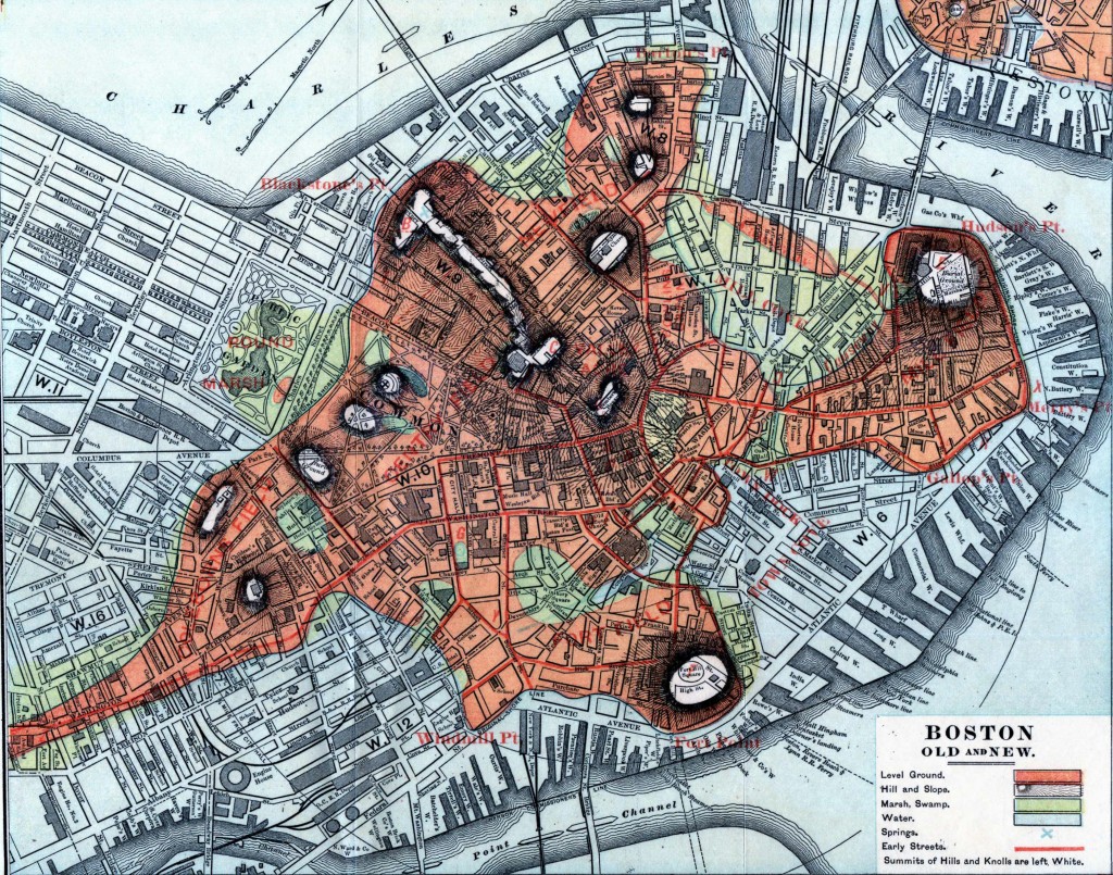
To even the most seasoned New Yorker the city south of 14th street can seem an almost alien city. Before the 1811 Commissioners Plan which created the NYC grid as we know it the city evolved more organically as cities had for millennial. Take a walk through Wall street and if it wasn’t for the forest of skyscrapers you would feel like you were navigating a European town. Downtown Boston has a similar feel as these two areas developed at the same time in the same organic ways.
But in 1811 these two cities took very different paths for their future growth. New York had a 13 mile island it had to tame and in 1811 the famous Commissioners Plan was adopted to regulate development by creating an monotonous grid of 155 streets and 16 avenues. Boston, due to its much more constrained geography, developed more like large puzzle pieces being added as the marshes and bays around the downtown area were filled, each with its own unique grid that didn’t conform to a greater plan (Bulfinch Triangle, South End, Back Bay).
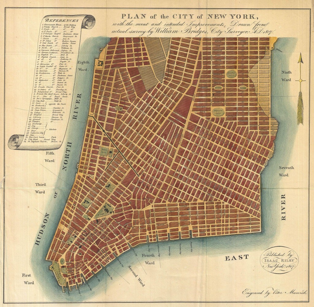
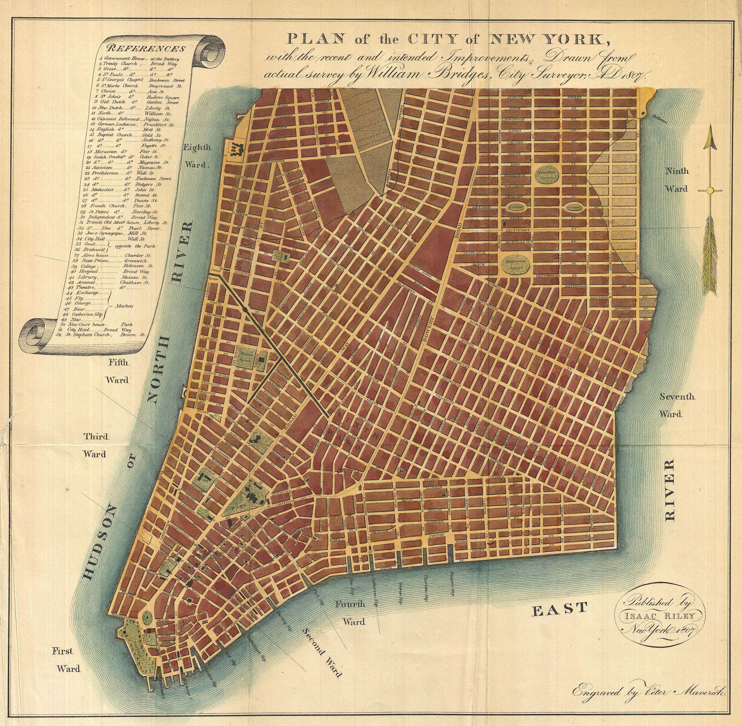
So when I discovered this peculiar map of lower Manhattan on Reddit’s Map Porn section I had to do a double take. Instead of the grid we know today the drafter of this map, published 4 years before the Commissioners Plan, proposed growing the city of New York in the same way that it had developed previously; that is to say large land holders would subdivide their farms (usually when the patriarch died) and would lay out new streets as they saw fit and connecting them to other streets at odd angles.
From the Wikipedia Commons:
An interesting and unusual map, this is William Bridges’ 1807 revival or the failed 1801 Mangin-Goerck Plan. Those who know New York’s shoreline will pause at the perfect blocks and ridged angles of this plan no more accurate today than it was in 1801 when Mangin first presented it. Mangin, a talented French architect, and Goerck, an established New York Surveyor, were commissioned by the Common Council of New York to prepare a new regulatory map of the city. Though Goerck passed away before the plan could be completed, Mangin finished the plan on a grand scale, re-envisioning New York City in his own image. Mangin even added streets such as Mangin Street and Goerck Street which would have been submerged under the East River had they actually existed (as a side note another of Mangin’s Street’s, South Street, did eventually appear). The Mangin-Goerck plan went far beyond the Common Council’s dreams of an administrative plan and, due to its inclusion of “intended improvementsâ€, new streets, and idealized block structure, enjoyed a short lifespan. It is curious then that in 1807 William Bridges, the talented City Surveyor who, in 1811, laid New York’s famous grid structure, resurrected and pirated the Mangin-Goerck Plan, attaching his own name to it. It was a private venture that led Bridges to piracy. He was commissioned by Dr. Samuel Mitchell to provide a map to illustrate Mitchell’s Picture of New York , a travel guide intended for foreign tourist. Perhaps Bridges chose the Mangin plan simply because, as a failed city plan, there were few obstacles to his use of it, but we do pity the hapless tourists who leapt into the east river in pursuit of Mangin Street. Though originally issued in 1807 for S. Mitchell’s Picture of New York , this example is a reissue prepared by John Hardy, Clerk of the Common Council, for the 1871 edition of the Manual of the Corporation of New York.
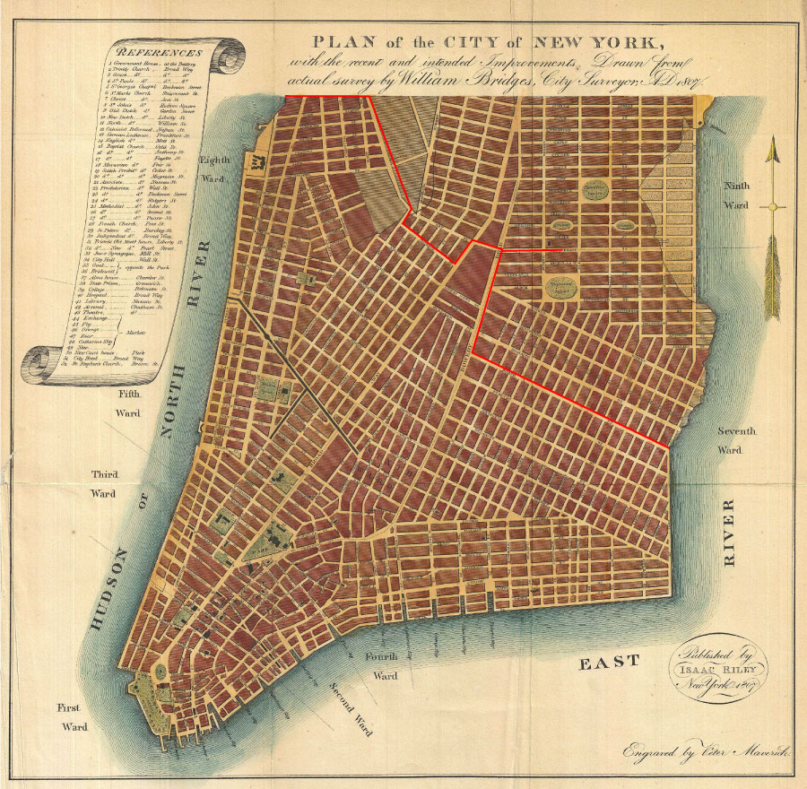
Like many maps and plans from this era it’s hard to tell what is real and what isn’t. Many city boosters published maps making their city look larger and more developed than rival cities even though the streets the maps depicted weren’t even cut yet! The red line on this version shows the dividing line between what is built today and what Bridges was proposing.
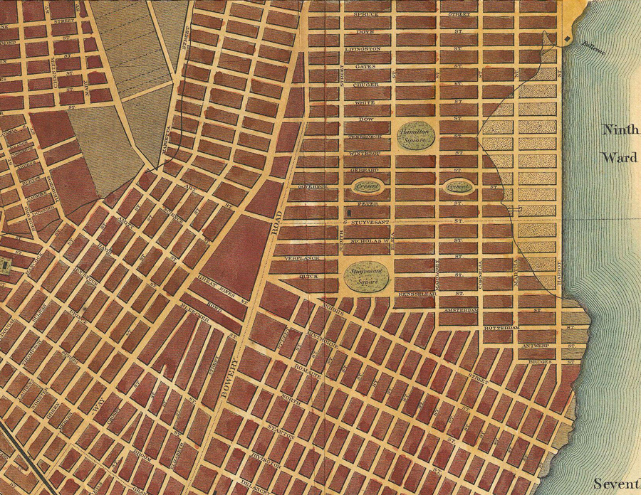
There is, however, one constant, a thorn in the side of the 1811 Commissioners Plan which is with us today: Stuyvesant Street. The large section north of Morris St on the 1807 map was the estate of Peter Stuyvesant, the famous Dutch Director-General who had the unfortunate privilege of surrendering the city to the English when the population of New Amsterdam refused to defend the city after his tyrannical rule (and you though Bloomberg was bad!). When Stuyvesant died the land which is today part of Gramercy, Stuyvesant Town (hence the name) and the East Village were given to his heirs who decided to subdivide and sell the land. The 1807 Bridges map shows this long forgotten plan. A few streets were laid but only three buildings were actually built before the city adopted the Commissioners Plan and demanded that the Stuyvesant heirs conform to the new plan. These three buildings still stand along a two block stretch of Stuyvesant St: St Mark’s Church-in-the-Bowery, the Hamilton-Fish House at 21 Stuyvesant St, and 44 Stuyvesant St (built in 1795).
The Stuyvesant plan envisioned a large wealthy neighborhood with streets running true North-South and East-West. It also (whether in the original plan or added later by Goerck) shows the addition of the newest urban design trend: London Squares. These public or private gardens offered it’s wealthy neighbors a refuge from the turbulent city. At this point in New York’s evolution there was only one existing such square, Hudson Sq (today’s St. John’s Park) which was a real estate development on the west side by Trinity Church (which historically took too long to develop as the wealthy residents of New York chose to settle along Broadway). These squares would have most likely been private and entry was only given to the neighbors, each with their own key. Gramercy Park is the only remaining park like this in New York.
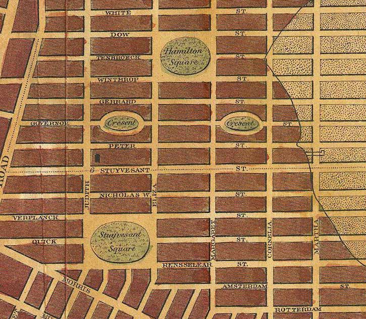
Two of these small parks, labeled as “Crescents” on the 1807 map, would have been more for show rather than for relaxing. Chester Sq in the South End of Boston is a perfect example of what was proposed.
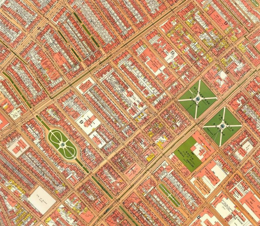
While the four squares in the Stuyvesant plan were never realized they live on today in almost the same place thanks to a visionary developer Samuel Ruggles who famously developed Gramercy Park, Union Sq, and had influence in the development of Stuyvesant Sq and Madison Sq.
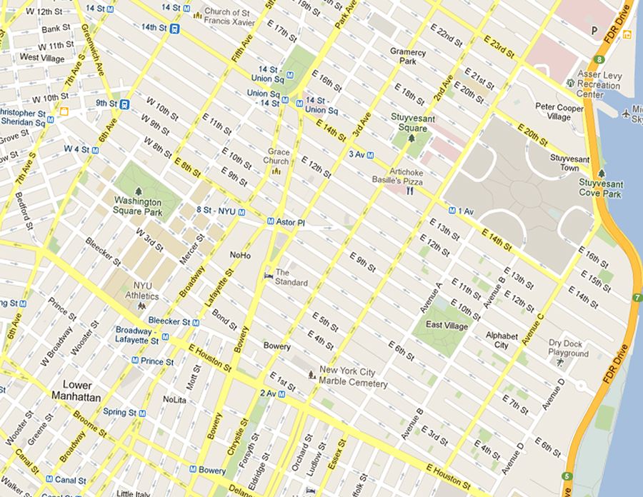
I’ve created this side-by-side comparison so you can see how the two grids are different but contain the same elements. Two things really stand out: the placement of Hamilton Sq is almost identical to the modern day Stuyvesant Sq and the East River was filled in about the same amount as proposed in 1807, just conforming to the new grid.

Poka Ross liked this on Facebook.
Tyler Cannon liked this on Facebook.
Nancy Palubniak liked this on Facebook.
Kate Farrish liked this on Facebook.