Printed on Satin finish 80# cover stock – 220 GSM. Made in the USA! Standard production time is 5 days. Allow more time for shipping.
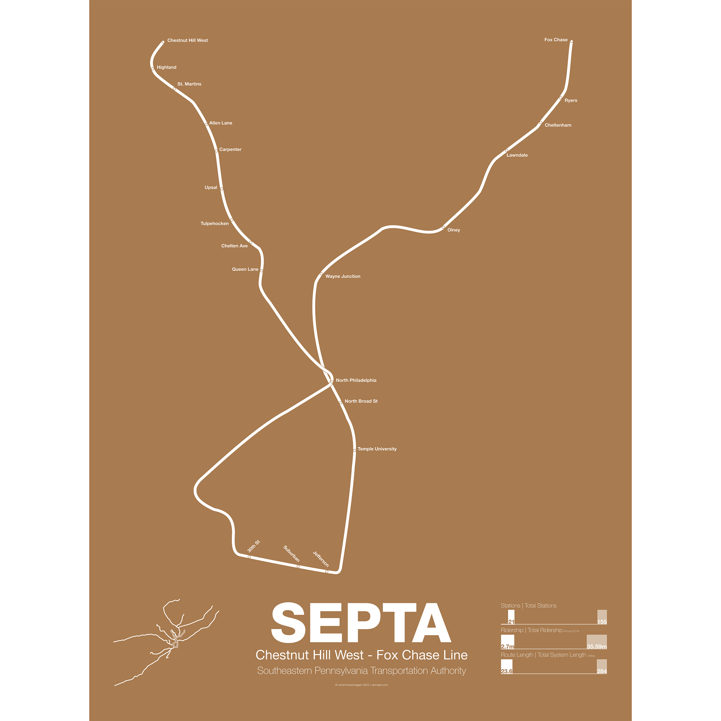
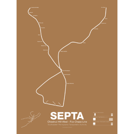
SEPTA Regional Rail R8: Chestnut Hill West – Fox Chase Line
$30.00 – $80.00
Additional information
| Weight | 1 lbs |
|---|---|
| Dimensions | 18 × 1 × 24 in |
| Size | Framed 18"x24", 18" x 24", 24" x 36 |
Related products
-
 $30.00 – $80.00
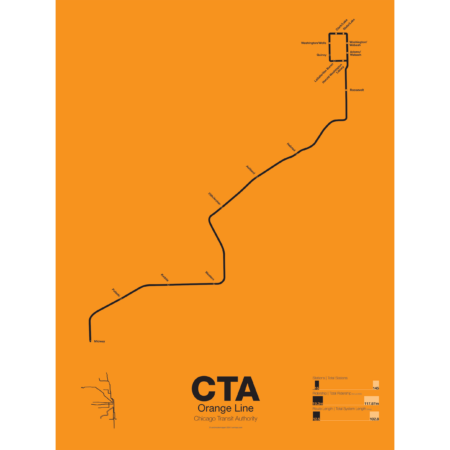
First proposed in the 1930s but only opened in 1993 the Orange Line serves the southwest section of Chicago and terminates at Midway Airport. Funding for the line was secured after the cancellation of the controversial Crosstown Expressway. For much of the route the Orange Line runs parallel to CSX and Conrail tracks but connects to the Loop in downtown Chicago. The original terminal at Ford City Mall was cut back due to cost savings but current studies are underway to extend the Orange Line past Midway to the mall.
Printed on Satin finish 80# cover stock – 220 GSM. Made in the USA! Standard production time is 5 Days. Please add more time for shipping.
Select options This product has multiple variants. The options may be chosen on the product page -
 $30.00 – $80.00
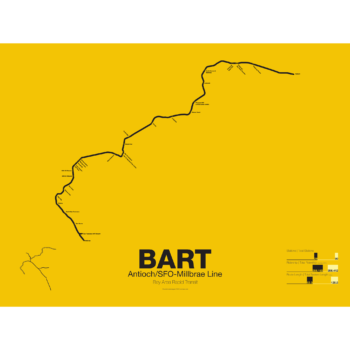
The Bay Area Rapid Transit system (BART) was, along with the WMATA in Washington D.C., one of the great centrally planned post-war rapid transit systems aimed at addressing the rise of the highway and auto-centric suburbs after World War II in the United States. Planning began in the 1950s for a unified high speed rail system that would serve both the dense inner cities of San Francisco and Oakland and their newly expanding low-rise suburbs. Stations would be spaced closer in the central business districts and further out in the suburbs.
Originally planned to connect Alameda, Contra Costa, Marin, San Francisco, and San Mateo counties BART was scaled back when San Mateo dropped out in favor of commuter rail service and the Marin line was dropped due to engineering concerns about running a rail line over the Golden Gate Bridge. Construction began in 1964 and the initial segments began to come online in 1972 and the majority of the system opening by 1974.
The Pittsburg/Bay Point–SFO/Millbrae Line, also known as the Pittsburg/Bay Point Line or the Concord Line (from the original terminus), was the second line to open in 1973 between Concord and MacArthur stations and extended to Daly City when the Transbay Tube opened in 1974.
In 1995 the line was extended northeast to Pittsburg/Bay Point Point and in 2003 the line was extended south to SFO/Millbrae.
The Pittsburg/Bay Point Line has the distinction of running with the longest train sets in the system; 10 car trains on weekdays and 8 or 9 car trains on evenings and weekends.
The section of track between Concord and Walnut Creek was the site of the BART groundbreaking ceremony in 1964 presided over by President Lyndon B. Johnson. Currently a new eBART system is being built east of Pittsburg/Bay Point station using Diesel Multiple Unit trains (as opposed to electric third-rail trains) to Antioch.
Printed on Satin finish 80# cover stock – 220 GSM. Made in the USA! Standard production time is 5 Days. Please add more time for shipping.
Select options This product has multiple variants. The options may be chosen on the product page -
 $30.00 – $80.00
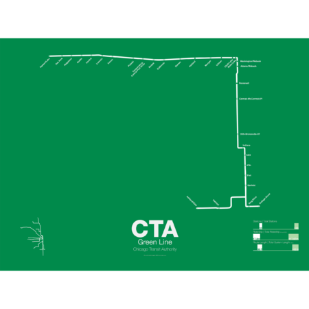
The Green Line is the modern combination of two of the oldest sections of the Chicago “L”. The South Side elevated opened in 1892 to serve the Columbian Exposition in 1893 and led to a building boom on the south side of Chicago. A number of branches were added to the line, to Englewood, Normal Park, Kenwood, and the Stock Yards. Today only the Englewood and Jackson Park branches remain while a number of stations have been closed due to low ridership.
The Lake St elevated was Chicago’s second elevated line opening in 1893. When the State St Subway opened in 1947 it was originally used by the South Side trains to connect to the north side and when the Dan Ryan Branch opened in 1969 it was used by the Lake St Line. In 1993 the CTA reorganized routings and color coded the new Lake St-South Side Lines as the Green Line.
Printed on Satin finish 80# cover stock – 220 GSM. Made in the USA! Standard production time is 5 Days. Please add more time for shipping.
Select options This product has multiple variants. The options may be chosen on the product page -
 $30.00 – $80.00
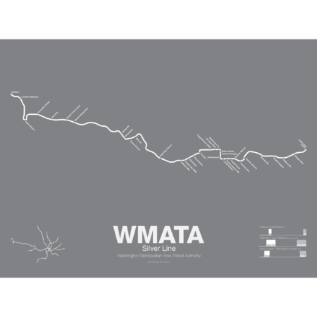
The Silver Line is the newest section of the Washington DC Metro with the section between East Falls Church and Wiehle-Reston East opened in July 2014 and the extension to Dulles Airport and Ashburn opened in 2022. The Silver Line shares much of its track with both the Orange and Blue Lines as it runs through downtown DC but branches off the Orange Line after East Falls Church station.
The Silver Line was built in most places along the median of the Dulles Access Road which itself was built in the 1960s with space left for a future rail line. Besides providing a direct link between DC and Dulles the Silver Line is also designed to mitigate the suburban sprawl in the Virginia suburbs which developed after the highway was opened. Tysons Corner, especially, will benefit as the Silver Line was routed through the center of town in order to support more traditional urban developments.
Printed on Satin finish 80# cover stock – 220 GSM. Made in the USA! Standard production time is 5 Days. Please add more time for shipping.
Select options This product has multiple variants. The options may be chosen on the product page