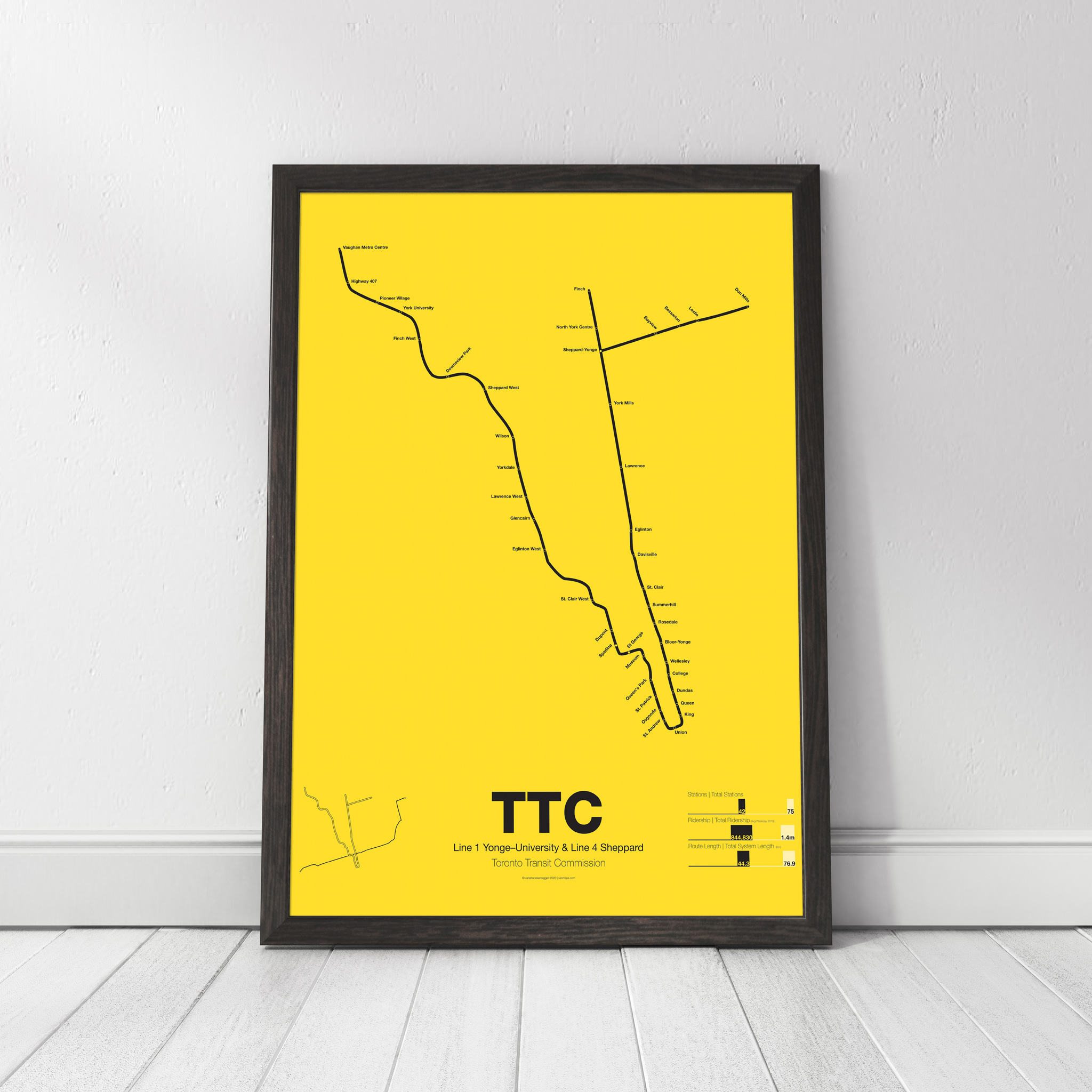
subway
-
 $30.00 – $80.00
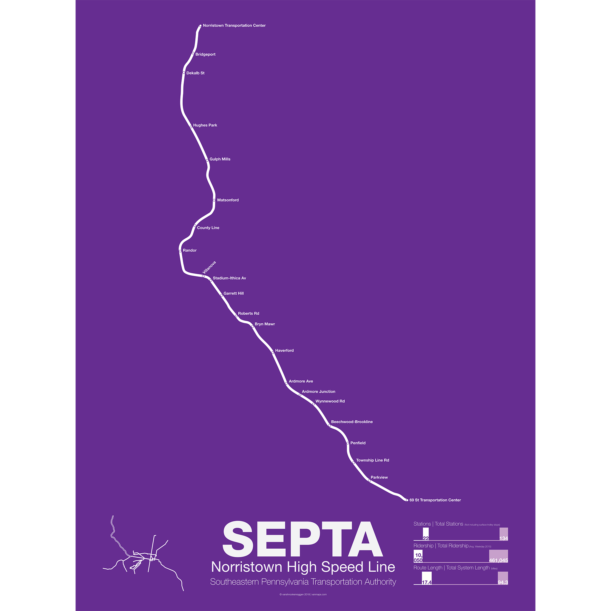
The Norristown High Speed Line (SEPTA route 100) began as a Philadelphia & Western Railroad interurban trolley in 1907 between the new 69th St Market-Frankford terminal and Strafford, PA. In 1912 a branch was built to Villanova and then extended to Norristown. The new branch proved more popular than the Strafford branch which was eventually abandoned in 1956. A year before, in 1955, the line was taken over by the Philadelphia Suburban Transportation Co (more commonly known as the Red Arrow Lines) along with Routes 101, 102, 103, and 104. Route 103 to Ardmore was abandoned in 1966 and Route 104 to West Chester was abandoned in 1958.
The Norristown High Speed Line runs four services, a local, the Norristown Express, Hughes Park Express (short turning at Hughes Park, and the Norristown Limited which only stops at 6 stations between Norristown and 69th St. Unlike the Market-Frankford Line and Routes 101 & 102 (which use a larger 5′ 2.5″ rail gauge) the Norristown Line uses a standard 4′ 8.5″ gauge meaning that service could not be extended into Philadelphia via the existing subway.
Printed on Satin finish 80# cover stock – 220 GSM. Made in the USA! Standard production time is 5 days. Allow more time for shipping.
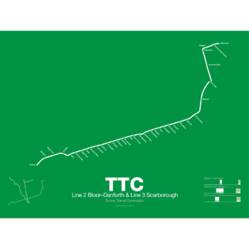
-
 $30.00 – $80.00
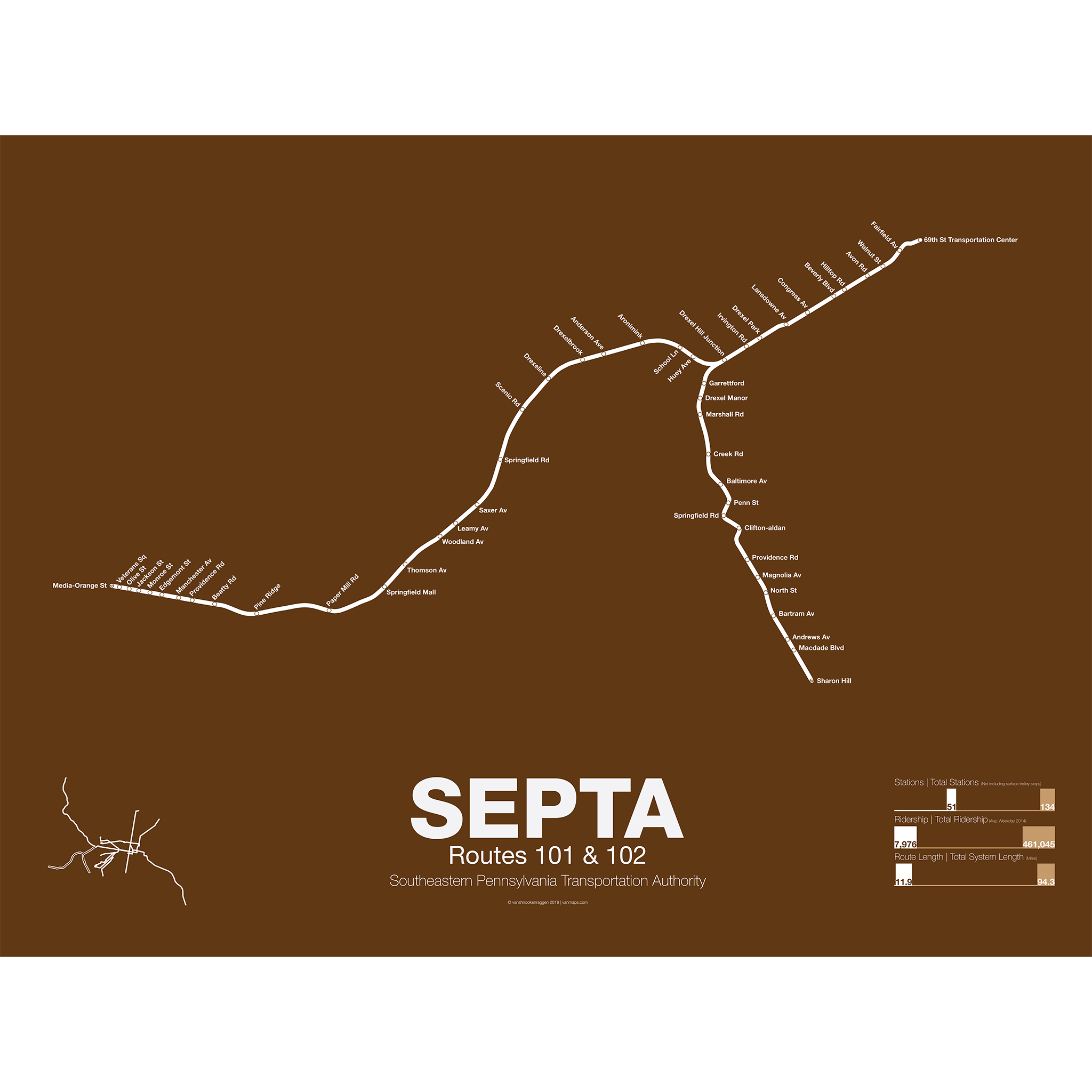
Routes 101 and 102, along with the Norristown HSL, are all that remains of the Philadelphia Suburban Transportation Company lines, commonly known as the Red Arrow Lines. Route 101, which dates from 1913, runs from downtown Media to 69th St Transportation center along a dedicated ROW but within Media along the street. Route 102, which dates from 1906, runs from Sharon Hill to 69th St.
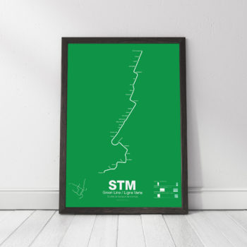
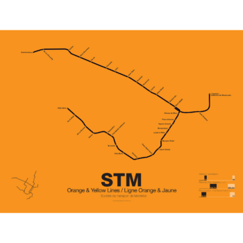
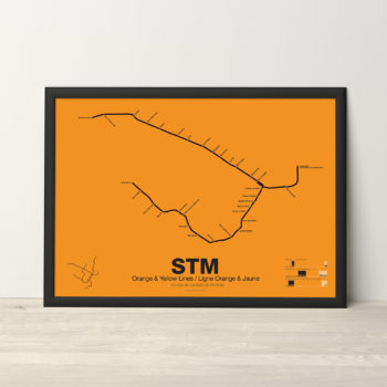
Routes 101 and 102 use the larger 5′ 2.5″ rail gauge which is also used by the Market-Frankford Line along with other trolleys in Philadelphia. The routes run a mixture of local and express services. Until a few years ago SEPTA gave these routes a brown color on the system map but recently changed them to green along with the Subway-Surface lines. To avoid confusion with the other poster the Routes 101 & 102 poster is the original brown.
Printed on Satin finish 80# cover stock – 220 GSM. Made in the USA! Standard production time is 5 days. Allow more time for shipping.
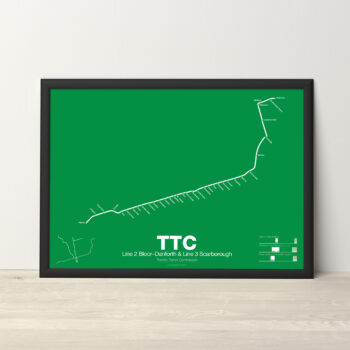
-
 $30.00 – $80.00
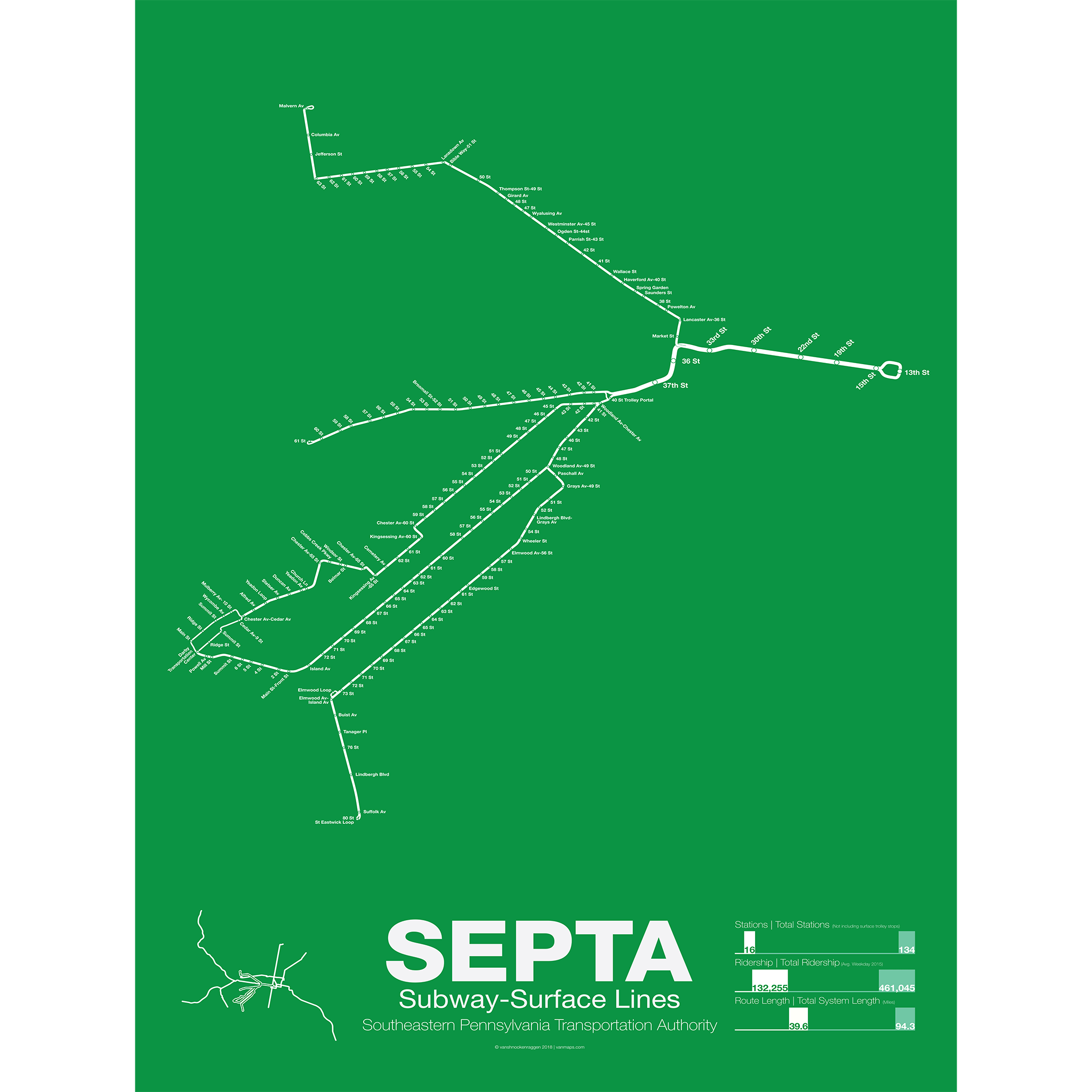
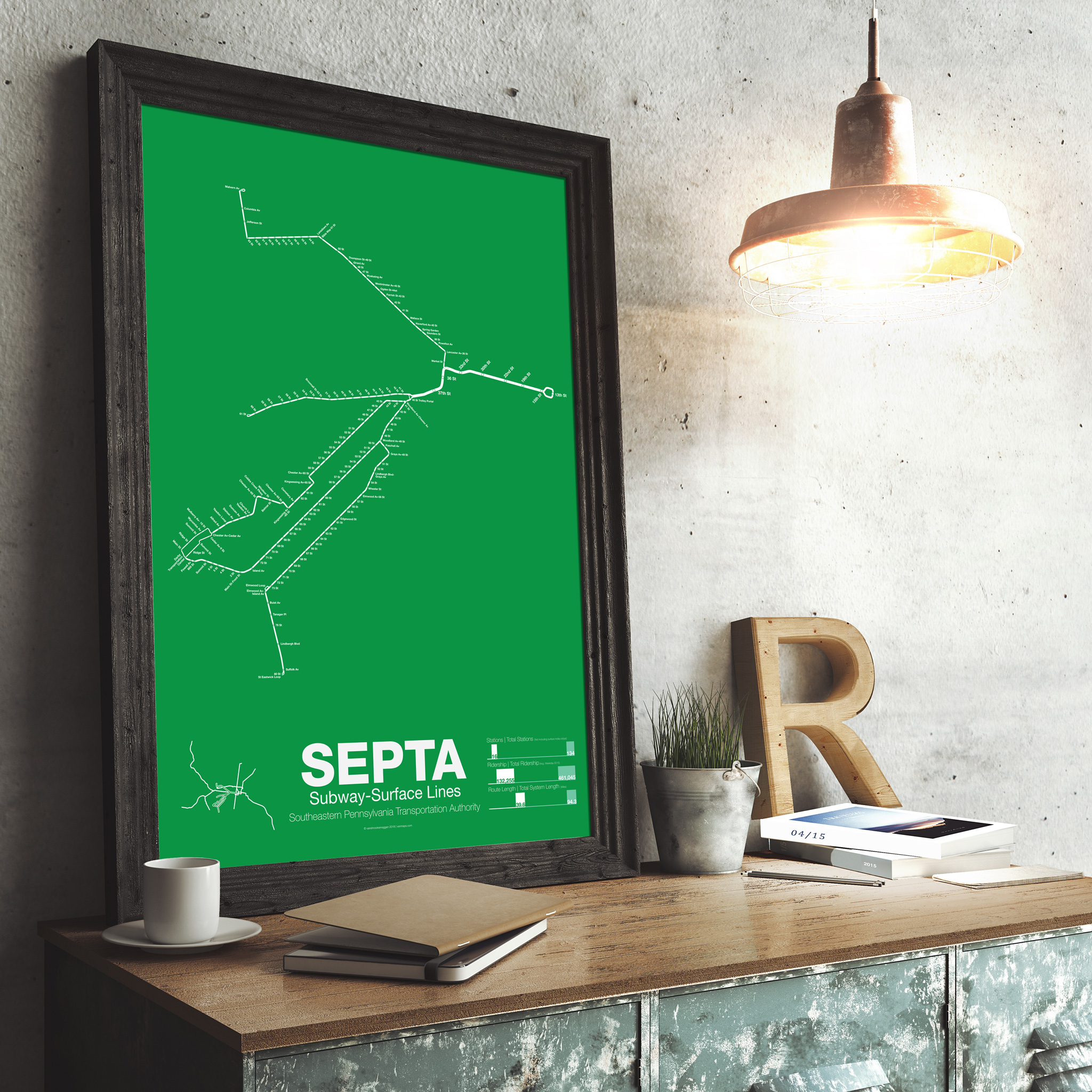
When the Market-Frankford subway opened in 1907 it provided two tracks for surface line streetcars to use with a loop at City Hall. Similar to Boston’s Green Line and San Francisco’s Market St Line the subway uses pre-WW2 streetcar lines as branches. After World War 2, like in most American cities, trolleys were converted to bus lines but in Philly there were many lines which never made the conversion. The streets of Philadelphia are lined with disused streetcar tracks but in West Philly there is still and active network; routes 10, 11, 13, 34, and 36 use the subway and Line 15 crosses the city along Girard Ave but does no use the subway (Line 15 is not included on the poster but is included on the mini-map). The original subway portal was located at 23rd St but when the Market-Frankford Subway tunnel was extended west so too was the trolley tunnel with a new portal at 36th and Ludlow Streets and another at 40th St between Baltimore and Woodland Aves.
The trolley lines have been threatened with replacement via bus or subway extension for decades but due to a lack of funds and popularity the streetcars remain and SEPTA is studying bringing back older lines as well. New cars are being purchased with low floors to help riders in wheelchairs and studies are being made looking at consolidating surface stops to speed up trips.
Printed on Satin finish 80# cover stock – 220 GSM. Made in the USA! Standard production time is 5 days. Allow more time for shipping.
-
 $30.00 – $80.00
Printed on Satin finish 80# cover stock – 220 GSM. Made in the USA! Standard production time is 5 Days. Please add more time for shipping.
-
 $30.00 – $80.00
Printed on Satin finish 80# cover stock – 220 GSM. Made in the USA! Standard production time is 5 Days. Please add more time for shipping.
-
 $30.00 – $80.00
Printed on Satin finish 80# cover stock – 220 GSM. Made in the USA! Standard production time is 5 Days. Please add more time for shipping.
-
 $45.00
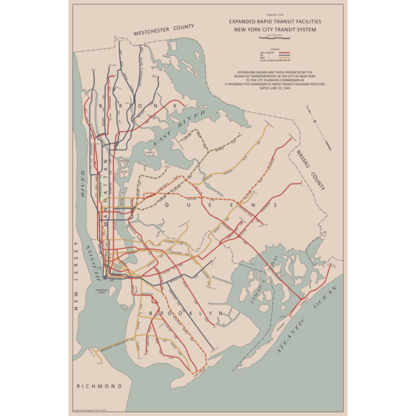
There are two “official” maps of the IND Subway’s expansion plans from the 1930s, colloquially known as the Second System. The plans for expansion evolved greatly as the IND was built. In the 1930s, the New York City subways were still operated by three separate companies. In 1940 the two private companies, the IRT and BMT were purchased by the City of New York under a unification plan. Thus, subway planners were able to imagine physically combining the three systems.
In 1940, John Delaney, Chairman of the Board of Transportation, outlined a new plan, with some additions in 1943. Until now, there were no maps of this plan. So I made one! The 1943 Lost IND Second System Map is probably the last time the city thought about such a large expansion program. The map here is based on the design of the 1939 map, with some changes.
To learn more about the history of this map, and see an outline of the ideas it shows, check out my post.
Printed on Satin finish 80# cover stock – 220 GSM, 24″ x 36″.
-
 $30.00 – $80.00
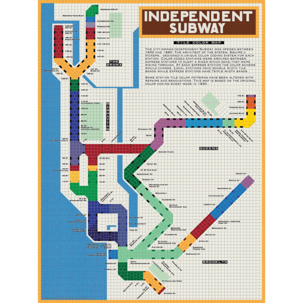
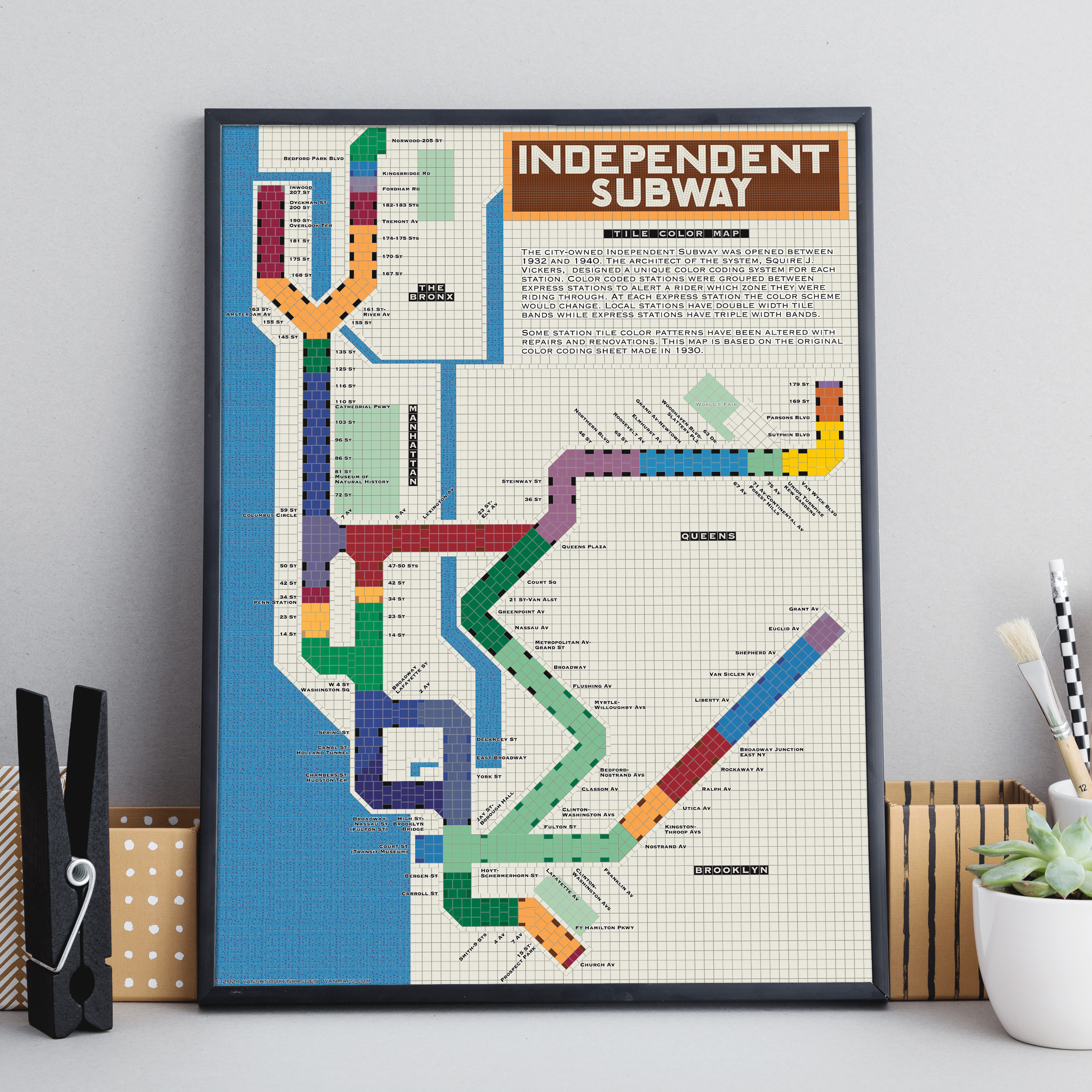
The City of New York built Independent Subway (A/B/C/D/E/F/G trains) was opened between 1932 and 1940. All the subway stations at the time featured tile bands and art unique to each station. The IND’s architect, Squire Vickers, created a new tile pattern based on color theory. He grouped express and local stations with color so that each time a rider rode through an express station the color of the tiles would change. He created a modern, streamlined design which featured two colors per station. The idea was that a rider would recognize their station’s color and know when to get off. This map shows how each color group looks when laid out like a subway map.
Note: The design features an orange tile outline. Some frames may obscure this outline.
Printed on Satin finish 80# cover stock – 220 GSM, 18″ x 24″.
-
 $30.00 – $80.00
Printed on Satin finish 80# cover stock – 220 GSM. Made in the USA! Standard production time is 5 Days. Please add more time for shipping.
-
 $30.00 – $80.00
Printed on Satin finish 80# cover stock – 220 GSM. Made in the USA! Standard production time is 5 Days. Please add more time for shipping.
-
 - 11 % Off
$290.00 – $415.00
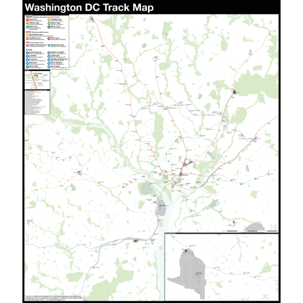
- 11 % Off
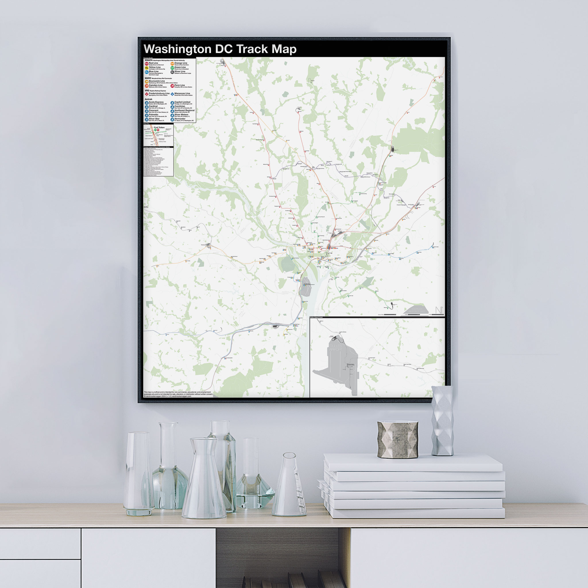
$290.00 – $415.00The Complete and Geographically Accurate track map of Washington DC is a new, detailed look at the entire rail network that most riders never see. Unlike a traditional subway map which just shows train routes, stations, and a simplified geography for easier navigation, the Track Map shows how the system actually looks; each track, each switch, each station platform and each train yard is shown in a clear and clean design. While the Track Map offers a service guide, it is not intended to replace the subway map as a wayfinding tool. The Track Map shows the paths of the tracks so that the viewer can see how trains are able to run. If you’ve ever wondered why certain trains don’t run to certain places, this map will tell you why.
The idea behind this was to remove all distortion from traditional subway maps and see the system down to its bones. Street labels, parks, cemeteries, and airports help act as landmarks. The more complicated interchanges and interlockings are shown in a blown up detail section along with a list of as many provisions and abandoned sections of the system I have discovered.
Fine art prints are made in Williamsburg, Brooklyn NY on Semi-Gloss, 10mil Premium Luster Paper.
-
 $30.00 – $80.00
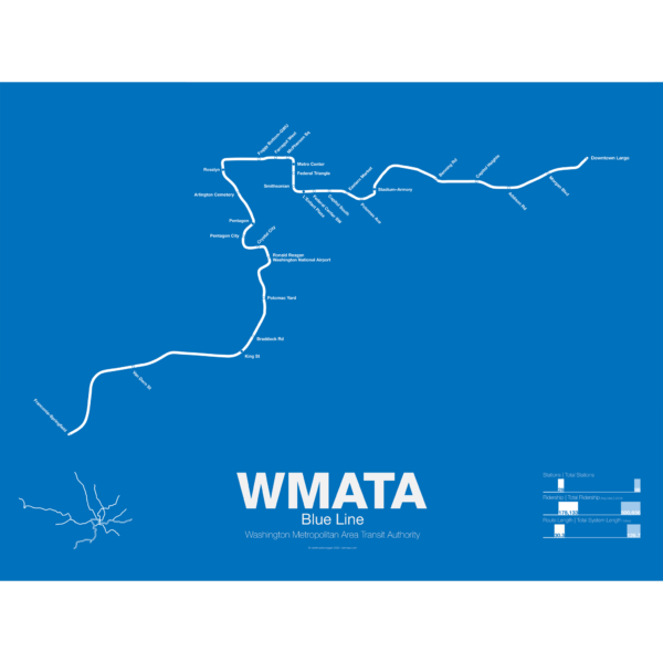
The Blue Line was the second section of the Washington Metro to open; on July 1st 1977 trains began running the familiar serpentine route from National Airport through Roslyn and Metro Center (at the time the only transfer station) to Stadium-Armory. In 1978 an extension to New Carrollton opened and service was split between Blue Line trains running from National Airport-New Carrollton and Orange Line trains running the reverse direction. When the Orange Line extension to Ballston opened a year later Blue Line trains were cut back to Stadium-Armory.
When the Addison Road branch opened in 1980 the Blue Line once again ran only one direction while Orange Line trains ran in the other direction, this time on both branches. In 1983 the Yellow Line was opened down to Huntington. This was originally to be the new terminal for Blue Line trains but due to a car shortage the Yellow Line, which required fewer cars, was extended instead, and this service pattern remains to this day. The extension to Van Dorn St (the originally planned terminal for the Yellow Line) didn’t open until 1991 and was extended to Franconia-Springfield in 1997. A final extension to Largo Town Center opened in 2004.
The Blue Line holds the distinction of the line which shares the most amount of track with other lines (the Orange and Yellow lines). In fact during rush hour service only the Arlington Cemetery station is served exclusively by Blue Line trains. Because of this, planners are looking at digging a new tunnel through central D.C. once the Silver Line opens which is also slated to share Blue Line tracks through downtown D.C.
Printed on Satin finish 80# cover stock – 220 GSM. Made in the USA! Standard production time is 5 Days. Please add more time for shipping.
-
 $30.00 – $80.00
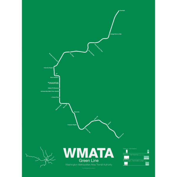
The Green Line was the final section of the original Washington Metro to open with trains not running until December 1991. While planning for the Green Line began at the same time as the rest of the system it was decided in 1977 to develop the route last. This decision sparked much controversy because the Green Line runs through areas of the city which are the poorest and most transit dependent.
Legal and funding issues dogged construction of the line. Station locations were also subject to much controversy and the ultimate route changed often. The northern section was to run in the median of the North Central Freeway but had to be changed when the freeway was canceled.
The Green Line shares its route through central D.C. with the Yellow Line. The first section ran from U St to Anacostia. Due to controversy over the route from U St to Fort Totten a small section of the Green Line from Fort Totten to Greenbelt opened first in 1993 with no physical connection to the other section of Green Line.
While the final section of subway from U St to Fort Totten was under construction some Green Line trains ran along the Red Line from West Hyattsville to Farragut North using a single non-revenue track connecting each line. In 1999 the connection between U St and Fort Totten was finally opened. In 2001 the Green Line was extended south to Branch Ave, thus completing the originally planned system 25 years after the first section was opened and 46 years after planning began.
Printed on Satin finish 80# cover stock – 220 GSM. Made in the USA! Standard production time is 5 Days. Please add more time for shipping.
-
 $30.00 – $80.00
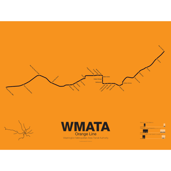
The Orange Line was the third leg of the Washington Metro to open, though service began running in 1978 as a one way service along the existing Blue Line from New Carrollton to National Airport. It wasn’t until a year later in 1979 that the Orange Line was extended out to Ballston when it began running in both directions. In 1986 the line was extended out to Vienna. Plans at the time to reroute the line through the fast developing Tysons Corner were eventually dropped to prevent a five year delay in construction.
These plans were resurrected with the Silver Line being built through Tysons Corner on its way to Dulles Airport. The Orange Line through Virginia runs along the median of Interstate 66 from Vienna to Falls Church. Originally the line was to run along the median of I-66 through Arlington but city planners rerouted it through downtown Arlington which helped stimulate dense residential development in central Arlington.
From Roslyn to Stadium-Armory the Orange and Blue lines share their downtown subway tunnel and split after ascending to the surface on a bridge over the Anacostia River. From here the Orange Line runs alongside the CSX/Amtrak ROW to New Carrollton.
Printed on Satin finish 80# cover stock – 220 GSM. Made in the USA! Standard production time is 5 Days. Please add more time for shipping.
-
 $30.00 – $80.00
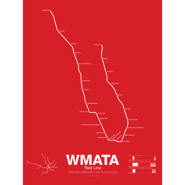
Breaking ground December 9th, 1969 the Red Line was the first section of the Washington Metro to open, from Farragut North to Rhode Island Ave, in 1976 in conjuncture with the nations Bicentennial. Over the next few years the line was extended to Dupont Circle and Silver Springs, MD and throughout the 1980s was slowly expanded to Shady Grove, MD and Wheaton, MD with a final extension to Glenmont opening in 1998.
The Red Line is the most used line in the WAMA system and the only line that doesn’t share a route with another line. A two track line, all but four of the stations are single central platforms. Most of the line is underground; however, the eastern branch from Union Station to Silver Springs and the western branch from White Flint to Shady Grove runs above ground along the Baltimore and Ohio Railroad right-of-way.
Printed on Satin finish 80# cover stock – 220 GSM. Made in the USA! Standard production time is 5 Days. Please add more time for shipping.
-
 $30.00 – $80.00
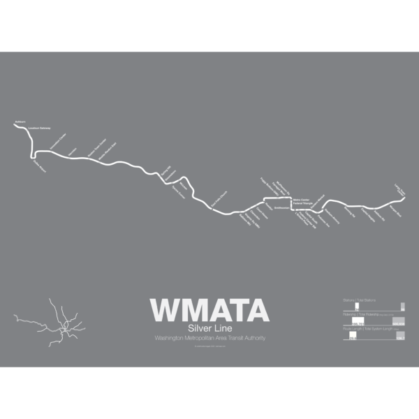
The Silver Line is the newest section of the Washington DC Metro with the section between East Falls Church and Wiehle-Reston East opened in July 2014 and the extension to Dulles Airport and Ashburn opened in 2022. The Silver Line shares much of its track with both the Orange and Blue Lines as it runs through downtown DC but branches off the Orange Line after East Falls Church station.
The Silver Line was built in most places along the median of the Dulles Access Road which itself was built in the 1960s with space left for a future rail line. Besides providing a direct link between DC and Dulles the Silver Line is also designed to mitigate the suburban sprawl in the Virginia suburbs which developed after the highway was opened. Tysons Corner, especially, will benefit as the Silver Line was routed through the center of town in order to support more traditional urban developments.
Printed on Satin finish 80# cover stock – 220 GSM. Made in the USA! Standard production time is 5 Days. Please add more time for shipping.
-
 $30.00 – $80.00
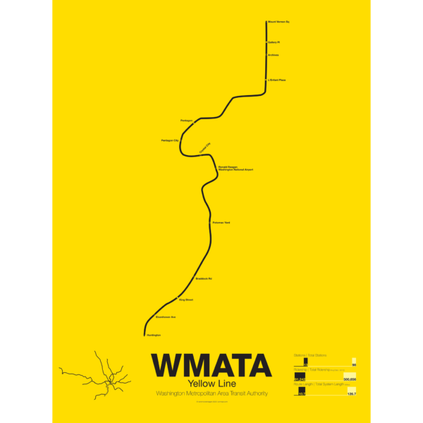
The Yellow Line was the fourth service of the Washington Metro to open and is today the shortest. Opened in 1983 connecting National Airport to Gallery Place the route acts as a bypass around downtown Arlington.
The route of the Yellow Line has deviated from the original planned route more than any other line. In December of 1983 the line was extended south to Huntington but was originally to run out to Franconia-Springfield (which didn’t open until 1997). A shortage of train cars caused this switch because the Yellow Line required fewer cars than the Blue Line which was routed out to Franconia-Springfield instead.
The Yellow Line was extended north to U St in 1991 but the final extension to Greenbelt was delayed because the original alignment along the median of the North Central Freeway was changed when that freeway was canceled. A new subway connection from U St to Fort Totten, the route subject to much controversy, was eventually opened in 1999 for Green Line service and in 2006 the Yellow Line was extended to Fort Totten.
Today the Yellow Line shares most of its route through Virginia with the Blue Line and all of its route through D.C. with the Green Line.
Printed on Satin finish 80# cover stock – 220 GSM. Made in the USA! Standard production time is 5 Days. Please add more time for shipping.