prints
-
 $30.00 – $80.00
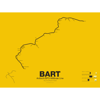
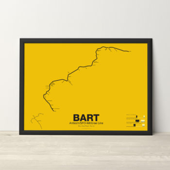
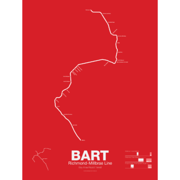
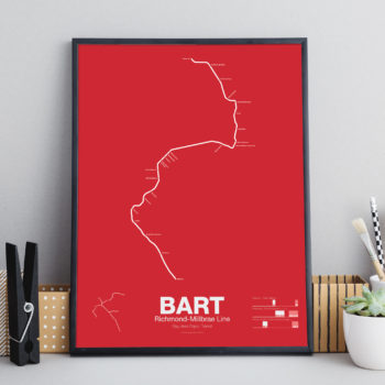
The Bay Area Rapid Transit system (BART) was, along with the WMATA in Washington D.C., one of the great centrally planned post-war rapid transit systems aimed at addressing the rise of the highway and auto-centric suburbs after World War II in the United States. Planning began in the 1950s for a unified high speed rail system that would serve both the dense inner cities of San Francisco and Oakland and their newly expanding low-rise suburbs. Stations would be spaced closer in the central business districts and further out in the suburbs.
Originally planned to connect Alameda, Contra Costa, Marin, San Francisco, and San Mateo counties BART was scaled back when San Mateo dropped out in favor of commuter rail service and the Marin line was dropped due to engineering concerns about running a rail line over the Golden Gate Bridge. Construction began in 1964 and the initial segments began to come online in 1972 and the majority of the system opening by 1974.
The Pittsburg/Bay Point–SFO/Millbrae Line, also known as the Pittsburg/Bay Point Line or the Concord Line (from the original terminus), was the second line to open in 1973 between Concord and MacArthur stations and extended to Daly City when the Transbay Tube opened in 1974.
In 1995 the line was extended northeast to Pittsburg/Bay Point Point and in 2003 the line was extended south to SFO/Millbrae.
The Pittsburg/Bay Point Line has the distinction of running with the longest train sets in the system; 10 car trains on weekdays and 8 or 9 car trains on evenings and weekends.
The section of track between Concord and Walnut Creek was the site of the BART groundbreaking ceremony in 1964 presided over by President Lyndon B. Johnson. Currently a new eBART system is being built east of Pittsburg/Bay Point station using Diesel Multiple Unit trains (as opposed to electric third-rail trains) to Antioch.
Printed on Satin finish 80# cover stock – 220 GSM. Made in the USA! Standard production time is 5 Days. Please add more time for shipping.
-
 $30.00 – $80.00
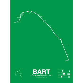
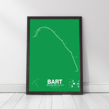
The Bay Area Rapid Transit system (BART) was, along with the WMATA in Washington D.C., one of the great centrally planned post-war rapid transit systems aimed at addressing the rise of the highway and auto-centric suburbs after World War II in the United States. Planning began in the 1950s for a unified high speed rail system that would serve both the dense inner cities of San Francisco and Oakland and their newly expanding low-rise suburbs. Stations would be spaced closer in the central business districts and further out in the suburbs.
Originally planned to connect Alameda, Contra Costa, Marin, San Francisco, and San Mateo counties BART was scaled back when San Mateo dropped out in favor of commuter rail service and the Marin line was dropped due to engineering concerns about running a rail line over the Golden Gate Bridge. Construction began in 1964 and the initial segments began to come online in 1972 and the majority of the system opening by 1974.
The Fremont-Daly City Line, also known as the Fremont Line, was the third BART line to open starting service in 1974 when the Trans-bay Tube opened. It runs until 7pm on weekdays as service is duplicated by the Dublin/Pleasanton Line and the Richmond-Fremont Line.
Construction has begun on a southern extension to San Jose; the first phase to Warm Springs/South Fremont opened in 2017 with the second phase to Milpitas and Berryessa opened in 2020.
Printed on Satin finish 80# cover stock – 220 GSM. Made in the USA! Standard production time is 5 Days. Please allow more time for shipping.
-
 $30.00 – $80.00
The Bay Area Rapid Transit system (BART) was, along with the WMATA in Washington D.C., one of the great centrally planned post-war rapid transit systems aimed at addressing the rise of the highway and auto-centric suburbs after World War II in the United States. Planning began in the 1950s for a unified high speed rail system that would serve both the dense inner cities of San Francisco and Oakland and their newly expanding low-rise suburbs. Stations would be spaced closer in the central business districts and further out in the suburbs.
Originally planned to connect Alameda, Contra Costa, Marin, San Francisco, and San Mateo counties BART was scaled back when San Mateo dropped out in favor of commuter rail service and the Marin line was dropped due to engineering concerns about running a rail line over the Golden Gate Bridge. Construction began in 1964 and the initial segments began to come online in 1972 and the majority of the system opening by 1974.
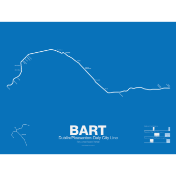
The Dublin/Pleasanton–Daly City Line, also known as the Dublin/Pleasanton Line, is the most recent BART line to open starting service in 1997. Branching off the
Fremont Line in Ashland it runs east along the median of I-580 to Dublin.
Plans are also being discussed to extend the line east to Livermore as either an electric third-rail BART train or Diesel Multiple Unit eBART train.
Printed on Satin finish 80# cover stock – 220 GSM. Made in the USA! Standard production time is 5 Days. Please allow more time for shipping.
-
 $30.00 – $80.00
The Bay Area Rapid Transit system (BART) was, along with the WMATA in Washington D.C., one of the great centrally planned post-war rapid transit systems aimed at addressing the rise of the highway and auto-centric suburbs after World War II in the United States. Planning began in the 1950s for a unified high speed rail system that would serve both the dense inner cities of San Francisco and Oakland and their newly expanding low-rise suburbs. Stations would be spaced closer in the central business districts and further out in the suburbs.
Originally planned to connect Alameda, Contra Costa, Marin, San Francisco, and San Mateo counties BART was scaled back when San Mateo dropped out in favor of commuter rail service and the Marin line was dropped due to engineering concerns about running a rail line over the Golden Gate Bridge. Construction began in 1964 and the initial segments began to come online in 1972 and the majority of the system opening by 1974.
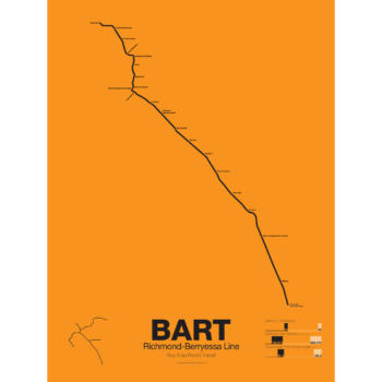
The Richmond-Warm Springs Line, also known as the East Bay Line, is the only line that does not enter San Francisco running from Richmond in the north through Oakland to Fremont in the south. Like most BART lines the Richmond-Fremont Line shares its tracks with other BART lines: the Richmond-Millbrae Line, the Pittsburg/Bay Point–SFO/Millbrae Line, the Fremont–Daly City Line, and the Dublin/Pleasanton–Daly City Line.
The Richmond–Fremont Line was the first of BART’s five lines to open. Service from MacArthur to Fremont began on September 11, 1972, the first day of BART operation and was extended to Richmond on January 29, 1973.
Construction has begun on a southern extension to San Jose; the first phase to Warm Springs/South Fremont opened in 2017 with the second phase to Milpitas and Berryessa opening in 2020.
Printed on Satin finish 80# cover stock – 220 GSM. Made in the USA! Standard production time is 5 days. Allow more time for shipping.
-
 $30.00 – $80.00
The Bay Area Rapid Transit system (BART) was, along with the WMATA in Washington D.C., one of the great centrally planned post-war rapid transit systems aimed at addressing the rise of the highway and auto-centric suburbs after World War II in the United States. Planning began in the 1950s for a unified high speed rail system that would serve both the dense inner cities of San Francisco and Oakland and their newly expanding low-rise suburbs. Stations would be spaced closer in the central business districts and further out in the suburbs.
Originally planned to connect Alameda, Contra Costa, Marin, San Francisco, and San Mateo counties BART was scaled back when San Mateo dropped out in favor of commuter rail service and the Marin line was dropped due to engineering concerns about running a rail line over the Golden Gate Bridge. Construction began in 1964 and the initial segments began to come online in 1972 and the majority of the system opening by 1974.
The Richmond-Millbrae Line, also known as the Richmond Line, was the fourth line to open in the BART system starting limited service in 1976. Because the Richmond Line shares its entire route with other BART lines it stops operations at 8pm on weekdays and 7pm on Saturdays. Originally terminating at Daly City the line was extended south in 2004 to SFO/Millbrae when that extension was opened sharing the line with the Pittsburg/Bay Point–SFO/Millbrae Line.
Printed on Satin finish 80# cover stock – 220 GSM. Made in the USA! Standard production is 5 Days. Please allow more time for shipping.
-
 $30.00 – $80.00
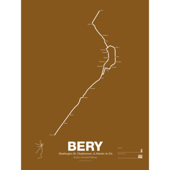
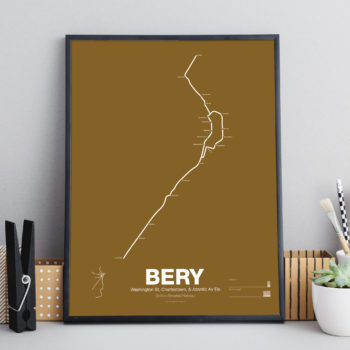
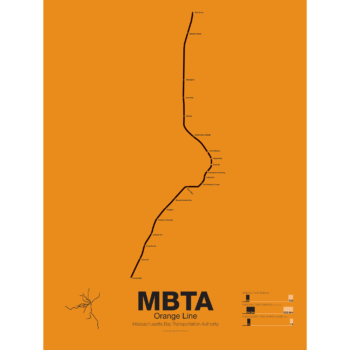
What is today the Orange Line was part of the original Boston Elevated Railway subway and elevated network. Today the only section remaining is the Washington St Tunnel from Haymarket to Chinatown. Originally there were two lines through downtown: the Main Line and the Atlantic Ave El. The Main Line served elevated branches from Charlestown and along Washington St to Dudley Sq. in the South End. The Atlantic Ave El ran from Castle Sq. in the South End to North Station along Atlantic Ave to serve the maritime industries along the waterfront.
As the city grew so did the elevated lines, being extended to Forest Hills and Everett (a further extension to Malden was halted until the 1970s). As the maritime industry faded and ridership dropped the Atlantic Ave El was demolished and sold for scrap during World War II.
While the El served the city well it was not popular as it was loud, dark, and dirty. Plans were laid as early as 1945 to remove the El and rebuild as a subway.
In the 1970s the city canceled ambitious plans to run highways through and around the city and monies were transferred to subway construction. The northern section was rebuilt first, removing the elevated tracks through Charlestown and moving them west along a new subway to Malden in 1975.
The southern section was rebuilt along the route for the canceled I-95 expressway through Jamaica Plain to Forest Hills in 1987. While the new Orange Line was modern and fast the new route bypassed the existing community of Roxbury which relied heavily on mass transit. Service along the old route was replaced by the Silver Line bus in 2002.
Printed on Satin finish 80# cover stock – 220 GSM. Made in the USA! Standard production time is 5 Days. Please add more time for shipping.
-
 $30.00 – $80.00
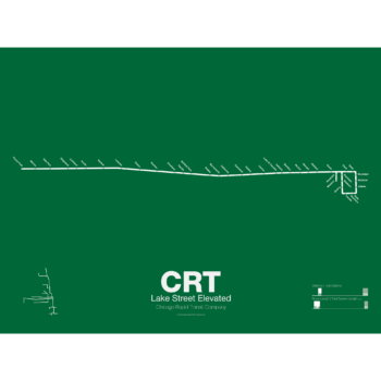
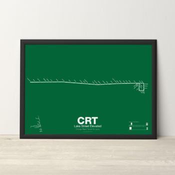
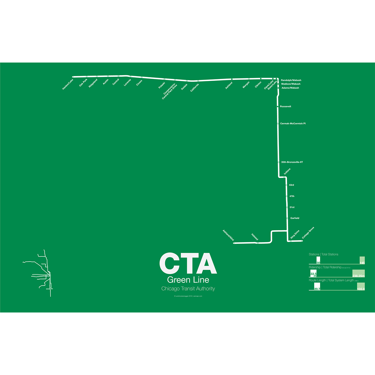
The Lake Street Elevated was Chicago’s second elevated line opening in 1893. In 1993 the CTA reorganized routes and color coded the new Lake St-South Side Lines as the Green Line.
Printed on Satin finish 80# cover stock – 220 GSM. Made in the USA! Standard production time is 5 Days. Please add more time for shipping.
-
 $30.00 – $80.00
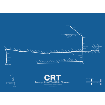
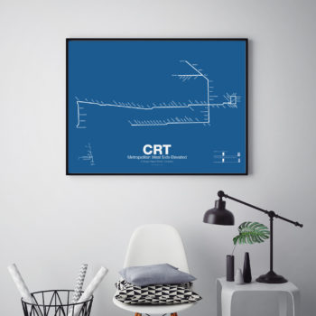
In 1895 the Metropolitan West Side Elevated Railroad began with service from Canal St to Logan Sq. Soon branches were added to Garfield Park, Humboldt Park, and Douglas Park. The Met, as it was known, has seen the most dramatic changes of all the Chicago “L” lines: the Humboldt Park and Logan Sq branches were removed when service was rerouted through the new Milwaukee-Dearborn Subway in 1951 and subsequently extended along the Kennedy Expressway to Jefferson Park in 1970 and then to O’Hare Airport in 1984. The Garfield Park branch was completely rebuilt along the median of Interstate 290 in 1958. In 2008 the Douglas Branch was rerouted along the Paulina Connector (a left over section of track from the old Logan Sq branch) to connect to the Loop and rebranded as the Pink Line.
Printed on Satin finish 80# cover stock – 220 GSM. Made in the USA! Standard production time is 5 Days. Please add more time for shipping.
-
 $30.00 – $80.00
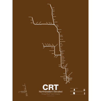
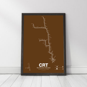
The Northwestern Elevated opened in 1907 and ran from a terminal on North Water St before it connected to Loop. The Main Line ran north to Evanston and a branch was built to Kimball. When the Northwestern was consolidated into the Chicago Rapid Transit Commission a second branch to Skokie was connected which once allowed interurban trains to run from the Loop to Milwaukee. The Northwestern division was split into the Brown, Purple, Yellow, and Red Lines.
Printed on Satin finish 80# cover stock – 220 GSM. Made in the USA! Standard production time is 5 Days. Please add more time for shipping.
-
 $30.00 – $80.00
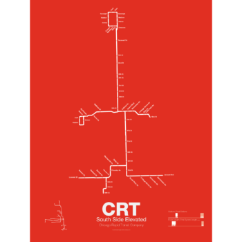
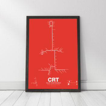
The South Side elevated opened in 1892 to serve the Columbian Exposition in 1893 and led to a building boom on the south side of Chicago. A number of branches were added to the line, to Englewood, Normal Park, Kenwood, and the Stock Yards. Today only the Englewood and Jackson Park branches remain while a number of stations have been closed due to low ridership.
Printed on Satin finish 80# cover stock – 220 GSM. Made in the USA! Standard production time is 5 Days. Please add more time for shipping.
-
 $30.00 – $80.00
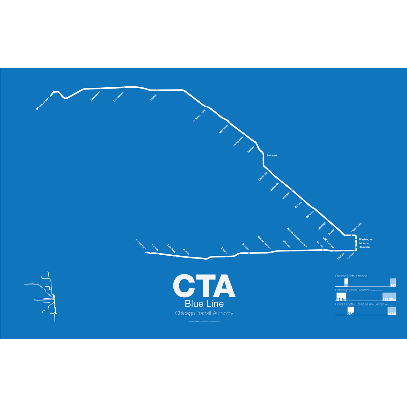
What today is the Blue Line started in 1895 as the Metropolitan West Side Elevated Railroad with service from Canal St to Logan Sq. Soon branches were added to Garfield Park, Humboldt Park, and Douglas Park. The Met, as it was known, has seen the most dramatic changes of all the Chicago “L” lines: the Humboldt Park and Logan Sq branches were removed when service was rerouted through the new Milwaukee-Dearborn Subway in 1951 and subsequently extended along the Kennedy Expressway to Jefferson Park in 1970 and then to O’Hare Airport in 1984. The Garfield Park branch was completely rebuilt along the median of Interstate 290 in 1958. In 2008 the Douglas Branch was rerouted along the Paulina Connector (a left over section of track from the old Logan Sq branch) to connect to the Loop and rebranded as the Pink Line.
The modern sections of the Blue Line were the first examples of rapid transit running along a high median in the US. The Blue Line, along with the Red Line, are the only two services of the CTA which run 24 hours a day.
Printed on Satin finish 80# cover stock – 220 GSM. Made in the USA! Standard production time is 5 Days. Please add more time for shipping.
-
 $30.00 – $80.00
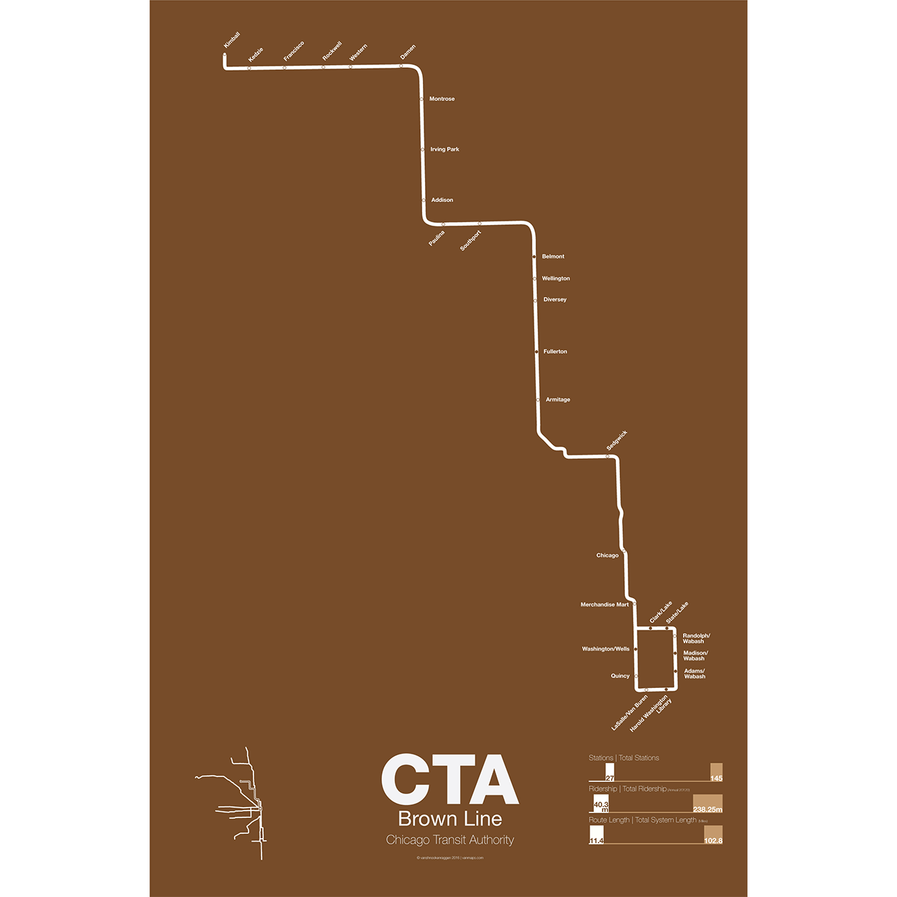
The Brown Line began as the Northwestern Elevated in 1907 and runs from its terminal at Kimball to the Loop and back, making a zig-zag through the northwest section of the city. At the terminal at Kimball trains run at street level with third-rail power which is rare for transit in the US and extremely dangerous for pedestrians. Brown Line trains run local with Red Line trains from Belmont to Fullerton. Recently the stations of the Brown Line were expanded and upgraded to be ADA compliant to deal with rapid population growth on the north side.
Printed on Satin finish 80# cover stock – 220 GSM. Made in the USA! Standard production time is 5 Days. Please add more time for shipping.
-
 $30.00 – $80.00
The Green Line is the modern combination of two of the oldest sections of the Chicago “L”. The South Side elevated opened in 1892 to serve the Columbian Exposition in 1893 and led to a building boom on the south side of Chicago. A number of branches were added to the line, to Englewood, Normal Park, Kenwood, and the Stock Yards. Today only the Englewood and Jackson Park branches remain while a number of stations have been closed due to low ridership.
The Lake St elevated was Chicago’s second elevated line opening in 1893. When the State St Subway opened in 1947 it was originally used by the South Side trains to connect to the north side and when the Dan Ryan Branch opened in 1969 it was used by the Lake St Line. In 1993 the CTA reorganized routings and color coded the new Lake St-South Side Lines as the Green Line.
Printed on Satin finish 80# cover stock – 220 GSM. Made in the USA! Standard production time is 5 Days. Please add more time for shipping.
-
 $30.00 – $80.00
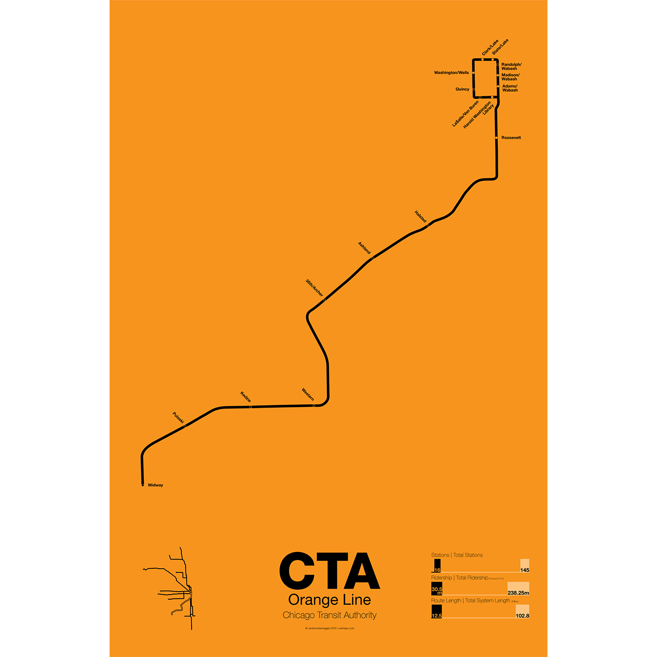
First proposed in the 1930s but only opened in 1993 the Orange Line serves the southwest section of Chicago and terminates at Midway Airport. Funding for the line was secured after the cancellation of the controversial Crosstown Expressway. For much of the route the Orange Line runs parallel to CSX and Conrail tracks but connects to the Loop in downtown Chicago. The original terminal at Ford City Mall was cut back due to cost savings but current studies are underway to extend the Orange Line past Midway to the mall.
Printed on Satin finish 80# cover stock – 220 GSM. Made in the USA! Standard production time is 5 Days. Please add more time for shipping.
-
 $30.00 – $80.00
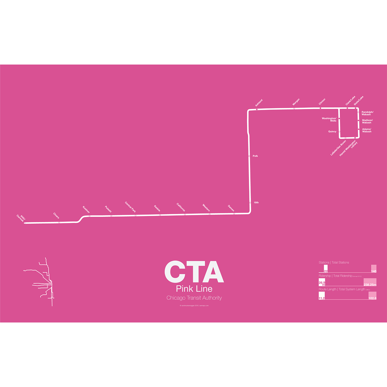
The Pink Line is the most recent addition to the CTA but uses some of the original tracks of the old Metropolitan West Side elevated. The Douglas Park branch opened in 1896 and ran as far west as Oak Park Ave until it was cut back to 54th Ave in Cicero. When the Garfield Park branch of the Met was removed and replaced by the Congress Line (running in the median of Interstate 290) the Douglas Park branch was connected to it and routed through the Milwaukee-Dearborn Subway.
The Congress-Douglas Lines operated a skip-stop service with stations being designated as A, B, or A/B. The Douglas branch ran B trains exclusively until this service was discontinued. In 2005 the CTA began studies looking at making the Douglas branch a separate line, originally known as the Silver Line. In 2006 a contest found that pink was the preferred choice. The CTA rehabilitated a section of track known as the Paulina Connector which was part of the original Metropolitan elevated but was connected to the Lake St Line. This allows Douglas branch trains to run over the Loop for the first time in half a century.
Printed on Satin finish 80# cover stock – 220 GSM. Made in the USA! Standard production time is 5 Days. Please add more time for shipping.
-
 $30.00 – $80.00
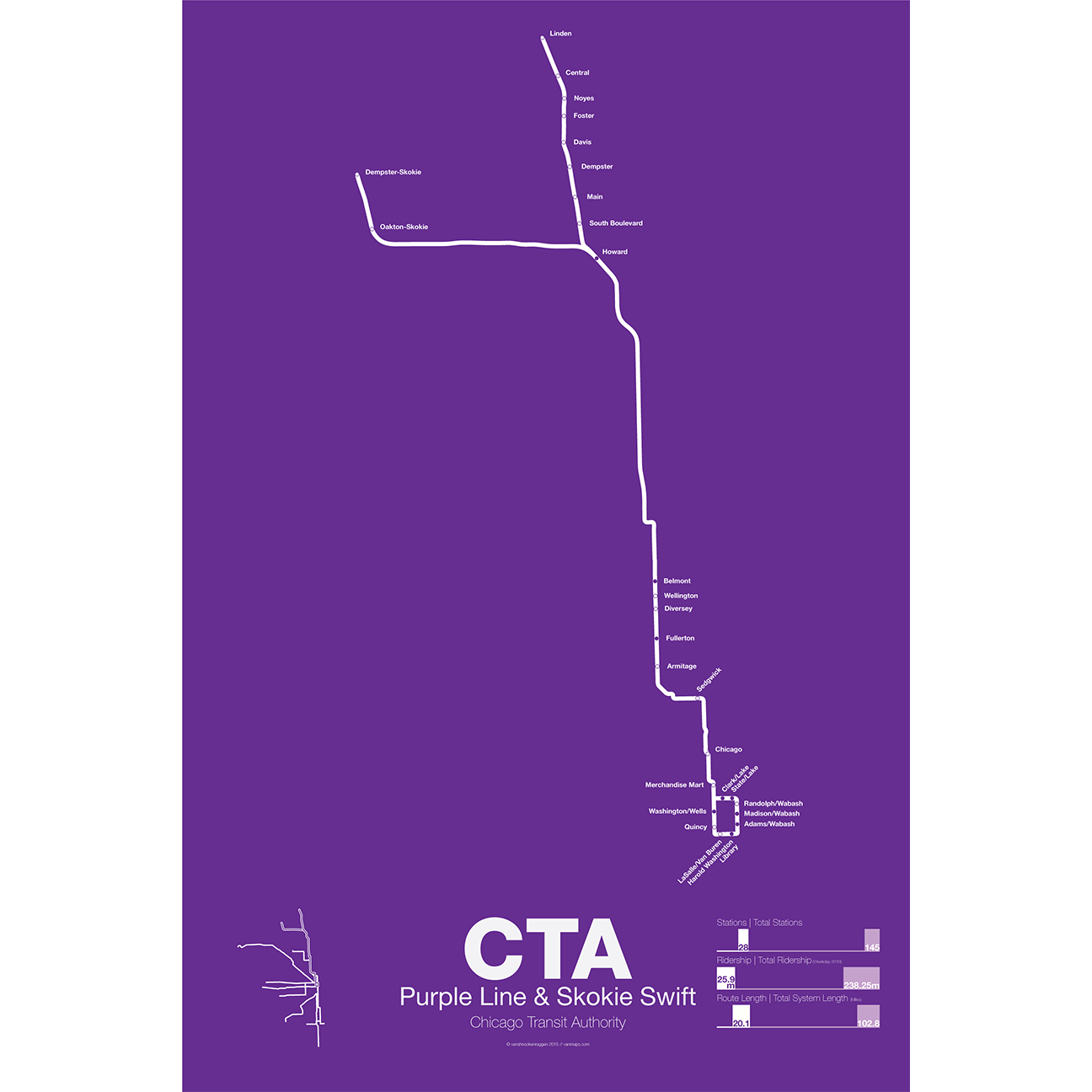
The Purple Line began as part of the Northwestern elevated, a bit of a misnomer as the line ran mostly at street level until it was expanded onto a 4 track elevated embankment in 1928. The line was extended to Evanston in 1908 and Wilmette in 1912. After 1928 the line began running express from Howard station to the Loop. In 1949 when the CTA took over operations the line was rerouted through the State St Subway as part of a new north-south route. This service was eventually replaced by the Red Line. Today the Purple Line runs from Linden to Howard days and express to the Loop at rush hour.
The Yellow Line, formerly known as the Skokie Swift, began as an interurban high speed line from Howard terminal to Dempster St in Niles Center (now known as Skokie). The line ceased operations in 1963 but was bought by the CTA and service restarted in 1964 with intermediate stations closed. The Yellow Line is the only line in the CTA which doesn’t run to downtown Chicago. In 2012 an infill station at Oakton was opened and a northern extension to Old Orchard Mall is being studied.
Printed on Satin finish 80# cover stock – 220 GSM. Made in the USA! Standard production time is 5 Days. Please add more time for shipping.
-
 $30.00 – $80.00
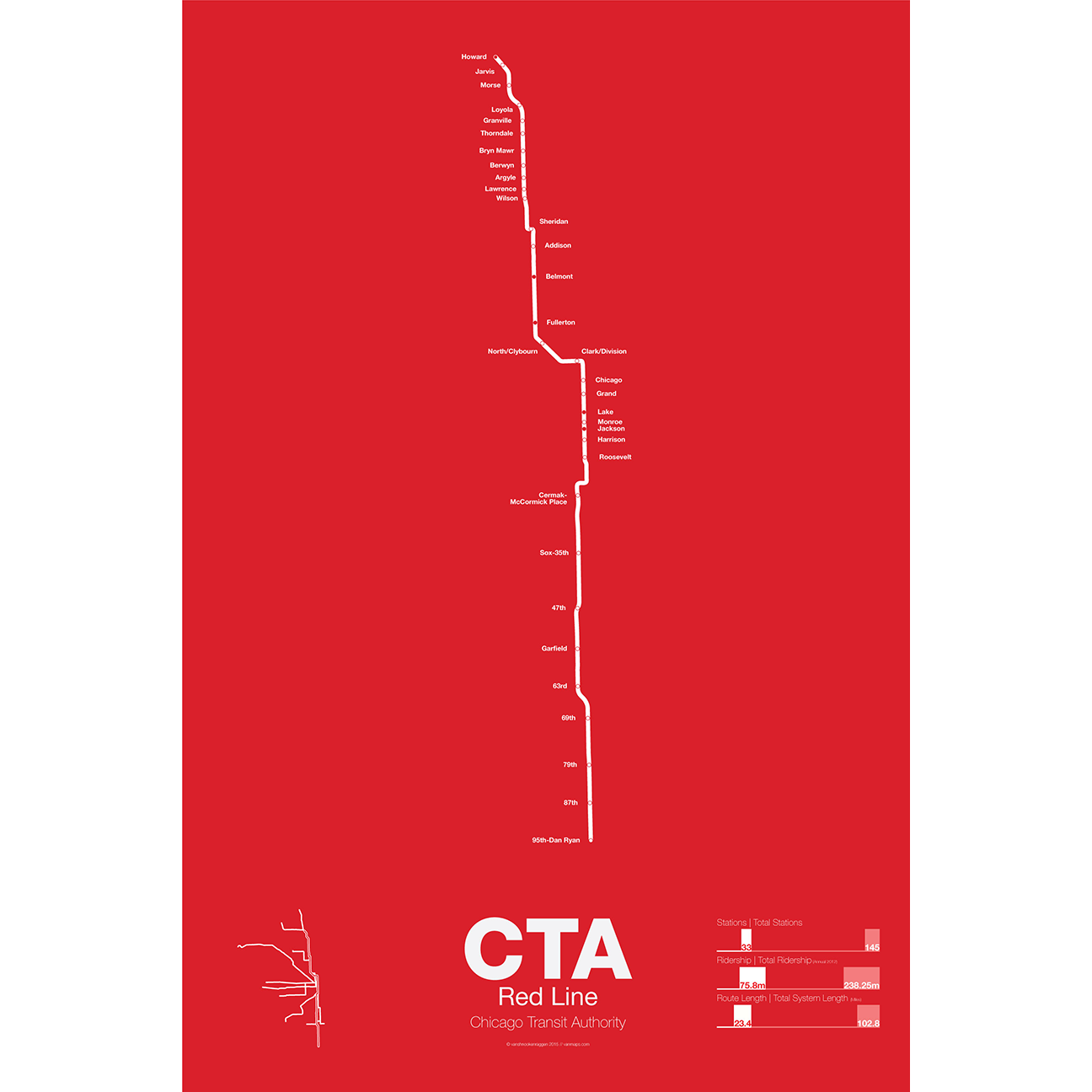
The Red Line is the busiest of all the Chicago “L” lines. The oldest section opened in 1900 as part of the North Side Main Line and starts at Howard station. One of the few lines in the United States which runs 24 hours a day it is also part of the only 4 track express subway in the US outside of New York City. In 1947 the State St Subway opened and allowed North Side trains to connect to the South Side elevated which is part of the Green Line today.
In 1969 the Dan Ryan Branch opened along the Dan Ryan Expressway but originally was connected to the Lake St elevated. In 1993 the CTA reorganized their lines with a new color code and the Dan Ryan Branch was shifted to the Red Line for a true north-south line. The CTA is currently studying plans to extend the Red Line south to 130th St.
Printed on Satin finish 80# cover stock – 220 GSM. Made in the USA! Standard production time is 5 Days. Please add more time for shipping.
-
 $30.00 – $80.00
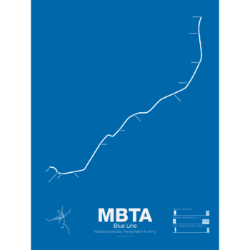
The Blue Line started off as a trolley tunnel to connect Scollay Sq. in downtown Boston to Maverick Sq. in East Boston. It holds the distinction as the first underwater transit tunnel (under a major body of water) opening in 1904. Initial plans called for it to be connected to the Green Line to form a subway trolley network connection all points north, east, south, and west. However, in 1924, the line was converted to heavy rail and extended to Bowdoin Sq. The Blue Line diverted traffic away from East Boston ferries which, ironically, helped bring the demise to the Atlantic Ave elevated line.
Until the 1950s the Blue Line was connected to the Red Line at Charles St so that Blue Line trains could be serviced at the Red Line train shops in Harvard Sq. In 1952 the Blue Line was extended to Suffolk Downs along the abandoned Boston, Revere Beach and Lynn Railroad and two years later extended to Revere where it still terminates at Wonderland.
Printed on Satin finish 80# cover stock – 220 GSM. Made in the USA! Standard production time is 5 Days. Please add more time for shipping.
-
 $30.00 – $80.00
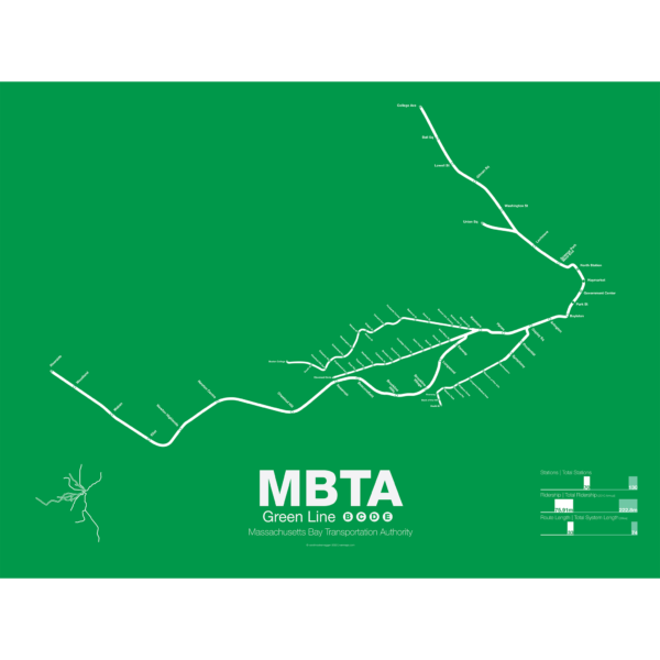
The Green Line is part of the oldest subway in the United States. The short section between Boylston St and Park St opened in 1897 as a way to divert heavy trolley traffic which came downtown from Allston, Brighton, Brookline, Jamaica Plane, Roxbury, and Dorchester. It was quickly expanded to North Station to serve trolley traffic from the northern suburbs.
As commuting patterns changed due in part to the success of the subway the Green Line was extended west to Kenmore Sq and in the 1940s southwest along Huntington Ave. As more and more commuters chose to travel in private automobiles ridership on the trolleys dropped. In 1959 the Riverside branch was opened along a former commuter rail line through Newton. A rebranding of the MBTA system in 1967 renamed the branches that were left as the A, B, C, D, and E branches. The A branch to Watertown Sq. only lasted two more years before finally being axed in 1969.
Boston College B Branch trains run along Commonwealth Ave to Government Center; Cleveland Cirlce C Branch trains run along Beacon St to North Station; Riverside D Branch trains run along the Riverside line through Newton to Government Center; Heath St E Branch trains run along Huntington Ave to Lechemere. Construction has begun on a long planned extension northwest through Somerville which will bring the E branch to Union Sq and the D to College Ave-Tufts University.
Printed on Satin finish 80# cover stock – 220 GSM. Made in the USA! Standard production time is 5 Days. Please add more time for shipping.
-
 $30.00 – $80.00
First opened in 1901 the Orange Line was the second part of Boston’s subway system to open. The tunnel under Tremont St was converted from trolleys to heavy rail to allow the new elevated trains from Charlestown to run through to Dudley Sq. in the South End. A second elevated section known as the Atlantic Ave El ran from Castle Sq. in the South End to North Station along Atlantic Ave to serve the maritime industries along the waterfront. In 1904 the Washington St tunnel was opened specifically for use by elevated trains and the Tremont St subway was switched back for trolley use.
The Orange Line was designed to collect commuters at elaborate transfer stations in Charlestown and Roxbury and quickly move them downtown. Suburban stations were spaced farther apart and downtown station platforms were built catty-corner from one another. This spread commuters out so that Boston’s notoriously narrow streets would not be over crowded by subway passengers.
As the city grew so did the Orange Line being extended to Forest Hills and Everett (a further extension to Malden was halted until the 1970s). As the maritime industry faded and ridership dropped the Atlantic Ave El was demolished and sold for scrap during World War II.
While the El served the city well it was not popular as it was loud, dark, and dirty. Plans were laid as early as 1945 to remove the El and rebuild as a subway.
In the 1970s the city canceled ambitious plans to run highways through and around the city and monies were transferred to subway construction. The northern section was rebuilt first, removing the elevated tracks through Charlestown and moving them west along a new subway to Malden in 1975.
The southern section was rebuilt along the route for the canceled I-95 expressway through Jamaica Plain to Forest Hills in 1987. While the new Orange Line was modern and fast the new route bypassed the existing community of Roxbury which relied heavily on mass transit. Service along the old route was replaced by the Silver Line bus in 2002.
Printed on Satin finish 80# cover stock – 220 GSM. Made in the USA! Standard production time is 5 Days. Please add more time for shipping.