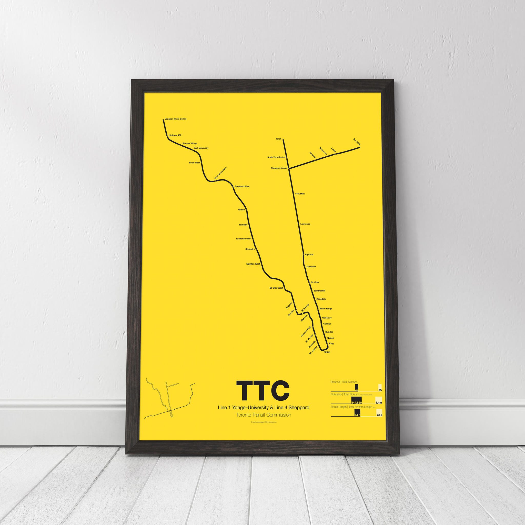
map
-
 $30.00 – $80.00
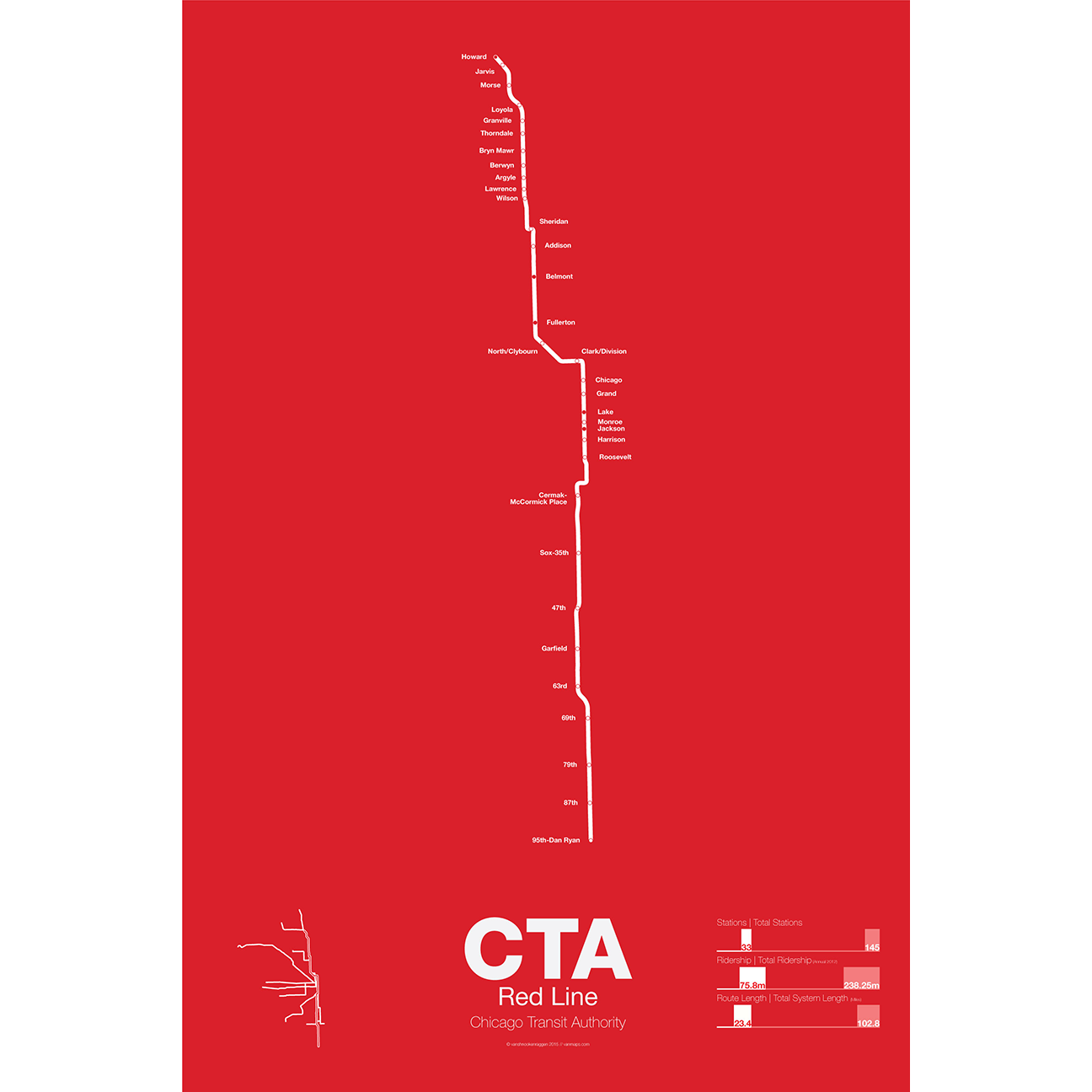
The Red Line is the busiest of all the Chicago “L” lines. The oldest section opened in 1900 as part of the North Side Main Line and starts at Howard station. One of the few lines in the United States which runs 24 hours a day it is also part of the only 4 track express subway in the US outside of New York City. In 1947 the State St Subway opened and allowed North Side trains to connect to the South Side elevated which is part of the Green Line today.
In 1969 the Dan Ryan Branch opened along the Dan Ryan Expressway but originally was connected to the Lake St elevated. In 1993 the CTA reorganized their lines with a new color code and the Dan Ryan Branch was shifted to the Red Line for a true north-south line. The CTA is currently studying plans to extend the Red Line south to 130th St.
Printed on Satin finish 80# cover stock – 220 GSM. Made in the USA! Standard production time is 5 Days. Please add more time for shipping.
-
 $375.00 – $500.00
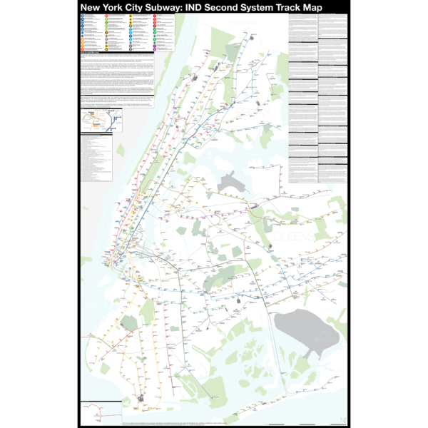
The Independent City-owned Subway System, IND, was created as alternative to the private traction companies, Interborough Rapid Transit Co., IRT, and the Brooklyn-Manhattan Transit Co., BMT. The IND broke ground on the 8th Ave Line in 1925 with plans for lines to Queens, Brooklyn, and the Bronx. In 1929 the IND released an ambitious plan for expanding the initial system. This plan became known as the IND Second System. In 1940 the City of New York was able to purchase the private companies and combine all three systems under the NYC Board of Transportation. In 1953 this evolved into the NY Transit Authority and in 1968 the state took control of the subways as part of the Metropolitan Transportation Authority.
The purpose of this map is the show the history of official subway expansion plans which can be broadly broken down into four phases: the 1929 Second System plan, the 1939 Second System plan, post-World War II plans, and the 1968 MTA Plan for Action.
The map acts as a “choose your own adventure” where by each variant of every plan is drawn. The reader can pick and choose which lines they think could have been built and what the system might have looked like today if they had.
Fine art prints are made in Williamsburg, Brooklyn NY on Semi-Gloss, 10mil Premium Luster Paper.
For more information about the map see the original blog post here.
-
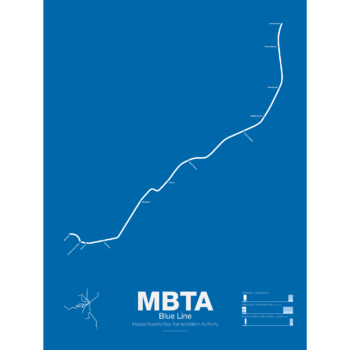
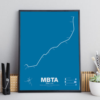 $30.00 – $80.00
The Blue Line started off as a trolley tunnel to connect Scollay Sq. in downtown Boston to Maverick Sq. in East Boston. It holds the distinction as the first underwater transit tunnel (under a major body of water) opening in 1904. Initial plans called for it to be connected to the Green Line to form a subway trolley network connection all points north, east, south, and west. However, in 1924, the line was converted to heavy rail and extended to Bowdoin Sq. The Blue Line diverted traffic away from East Boston ferries which, ironically, helped bring the demise to the Atlantic Ave elevated line.
Until the 1950s the Blue Line was connected to the Red Line at Charles St so that Blue Line trains could be serviced at the Red Line train shops in Harvard Sq. In 1952 the Blue Line was extended to Suffolk Downs along the abandoned Boston, Revere Beach and Lynn Railroad and two years later extended to Revere where it still terminates at Wonderland.
Printed on Satin finish 80# cover stock – 220 GSM. Made in the USA! Standard production time is 5 Days. Please add more time for shipping.
-
 $30.00 – $80.00
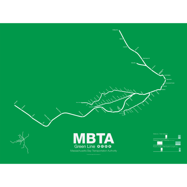
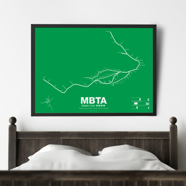
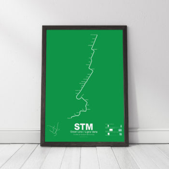
The Green Line is part of the oldest subway in the United States. The short section between Boylston St and Park St opened in 1897 as a way to divert heavy trolley traffic which came downtown from Allston, Brighton, Brookline, Jamaica Plane, Roxbury, and Dorchester. It was quickly expanded to North Station to serve trolley traffic from the northern suburbs.
As commuting patterns changed due in part to the success of the subway the Green Line was extended west to Kenmore Sq and in the 1940s southwest along Huntington Ave. As more and more commuters chose to travel in private automobiles ridership on the trolleys dropped. In 1959 the Riverside branch was opened along a former commuter rail line through Newton. A rebranding of the MBTA system in 1967 renamed the branches that were left as the A, B, C, D, and E branches. The A branch to Watertown Sq. only lasted two more years before finally being axed in 1969.
Boston College B Branch trains run along Commonwealth Ave to Government Center; Cleveland Cirlce C Branch trains run along Beacon St to North Station; Riverside D Branch trains run along the Riverside line through Newton to Government Center; Heath St E Branch trains run along Huntington Ave to Lechemere. Construction has begun on a long planned extension northwest through Somerville which will bring the E branch to Union Sq and the D to College Ave-Tufts University.
Printed on Satin finish 80# cover stock – 220 GSM. Made in the USA! Standard production time is 5 Days. Please add more time for shipping.
-
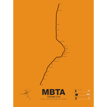
 $30.00 – $80.00
First opened in 1901 the Orange Line was the second part of Boston’s subway system to open. The tunnel under Tremont St was converted from trolleys to heavy rail to allow the new elevated trains from Charlestown to run through to Dudley Sq. in the South End. A second elevated section known as the Atlantic Ave El ran from Castle Sq. in the South End to North Station along Atlantic Ave to serve the maritime industries along the waterfront. In 1904 the Washington St tunnel was opened specifically for use by elevated trains and the Tremont St subway was switched back for trolley use.
The Orange Line was designed to collect commuters at elaborate transfer stations in Charlestown and Roxbury and quickly move them downtown. Suburban stations were spaced farther apart and downtown station platforms were built catty-corner from one another. This spread commuters out so that Boston’s notoriously narrow streets would not be over crowded by subway passengers.
As the city grew so did the Orange Line being extended to Forest Hills and Everett (a further extension to Malden was halted until the 1970s). As the maritime industry faded and ridership dropped the Atlantic Ave El was demolished and sold for scrap during World War II.
While the El served the city well it was not popular as it was loud, dark, and dirty. Plans were laid as early as 1945 to remove the El and rebuild as a subway.
In the 1970s the city canceled ambitious plans to run highways through and around the city and monies were transferred to subway construction. The northern section was rebuilt first, removing the elevated tracks through Charlestown and moving them west along a new subway to Malden in 1975.
The southern section was rebuilt along the route for the canceled I-95 expressway through Jamaica Plain to Forest Hills in 1987. While the new Orange Line was modern and fast the new route bypassed the existing community of Roxbury which relied heavily on mass transit. Service along the old route was replaced by the Silver Line bus in 2002.
Printed on Satin finish 80# cover stock – 220 GSM. Made in the USA! Standard production time is 5 Days. Please add more time for shipping.
-
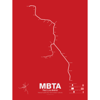
 $30.00 – $80.00
In 1912 the Red Line benefited from being the last of the original subways in Boston to open. A decade of subway building allowed the Red Line to be designed with larger trains and platforms that were easier to navigate (unlike the disconnected Orange Line platforms). Planned as an elevated subway until the citizens of Cambridge objected, the original route connected Harvard Sq. with Park St. At Harvard Sq. a parallel subway was built for trolleys to transfer commuters from the northwestern suburbs and is still in use today.
The Red Line was quickly extended to South Boston and large transfer stations were built at Broadway and Andrew Sq. to collect trolley (and later bus) commuters coming from Dorchester.
In 1926 and 1927 the Red Line was extended to Ashmont in Dorchester along the route of and old commuter rail road. Though the subway was proposed to be extended further to Mattapan the residents of Milton and southern Dorchester opted for a high speed trolley route instead, pre-dating the concept of light rail.
Plans were drawn up to create a new branch of the Red Line to Braintree as early as 1945 but construction didn’t begin for another 20 years. First to Quincy in 1971 and finally to Braintree in 1980 the new branch was designed to bypass Dorchester for a quicker commute.
At the other end the Red Line was extended northwest from Harvard Sq. to Alewife in 1985. Originally planned to run out to Lexington along the abandoned Boston and Maine Railroad the line was cut back when residents of Arlington protested.
The Red Line runs two heavy rail routes, Alewife-Ashmont and Alewife-Braintree (which skips Savin Hill).
A light rail section runs from Ashmont to Mattapan using refurbished PPC trolleys from the 1940s.
Printed on Satin finish 80# cover stock – 220 GSM. Made in the USA! Standard production time is 5 Days. Please allow more time for shipping.
-
 $45.00
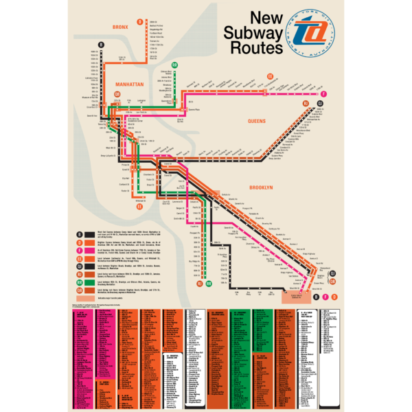
“I defy anyone to take this psychedelic creation and figure out how to get anywhere!” -State Senator Albert B. Lewis 1967.
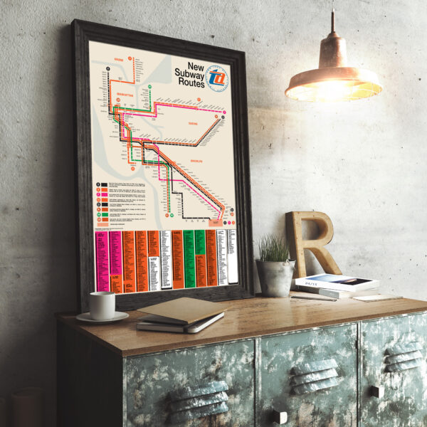
The Chrystie Street Connection didn’t just revolutionize how commuters got around by creating new subway lines but it also helped usher in a new era of modernist wayfinding and system maps. Chrystie St took a decade to build and knit together the once separate BMT and IND subway systems to create a new network which we still use today. This map was part of a brochure issued when the first new lines were opening in November 1967. This map was the first to introduce the idea that each line would be shown with its own color and lettered bullet, simplifying naming conventions. For a further look at the Chrystie St Connection check out my blog post!
This map has been carefully recreated down to the exact typeface. Included at the bottom was the reverse side of the original brochure, featuring a station by station listing of each new line. Printed on Satin finish 80# cover stock – 220 GSM, 24″ x 36″.
-
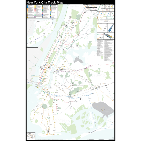
 $375.00 – $500.00
NEW version 2!
The Complete and Geographically Accurate New York City Track Map is a new detailed look at the entire rail network that most riders never see. Unlike a traditional subway map which just shows train routes, stations, and a simplified geography for easier navigation, the Track Map shows how the system actually looks; each track, each switch, each station platform and each train yard is shown in a clear and clean design. While the Track Map offers a service guide it is not intended to replace the subway map as a wayfinding tool. The Track Map shows the paths of the tracks so that the viewer can see how trains are able to run. If you’ve ever wondered why certain trains don’t run to certain places this map will tell you why.
The idea behind this was to remove all distortion from traditional subway maps and see the system down to its bones. Street labels, parks, cemeteries, and airports help act as landmarks. The more complicated interchanges and interlockings are shown in a blown up detail section along with a list of as many provisions and abandoned sections of the system I have discovered.
Fine art prints are made in Williamsburg, Brooklyn NY on Semi-Gloss, 10mil Premium Luster Paper.
For more information about the map see the original blog post here.
-
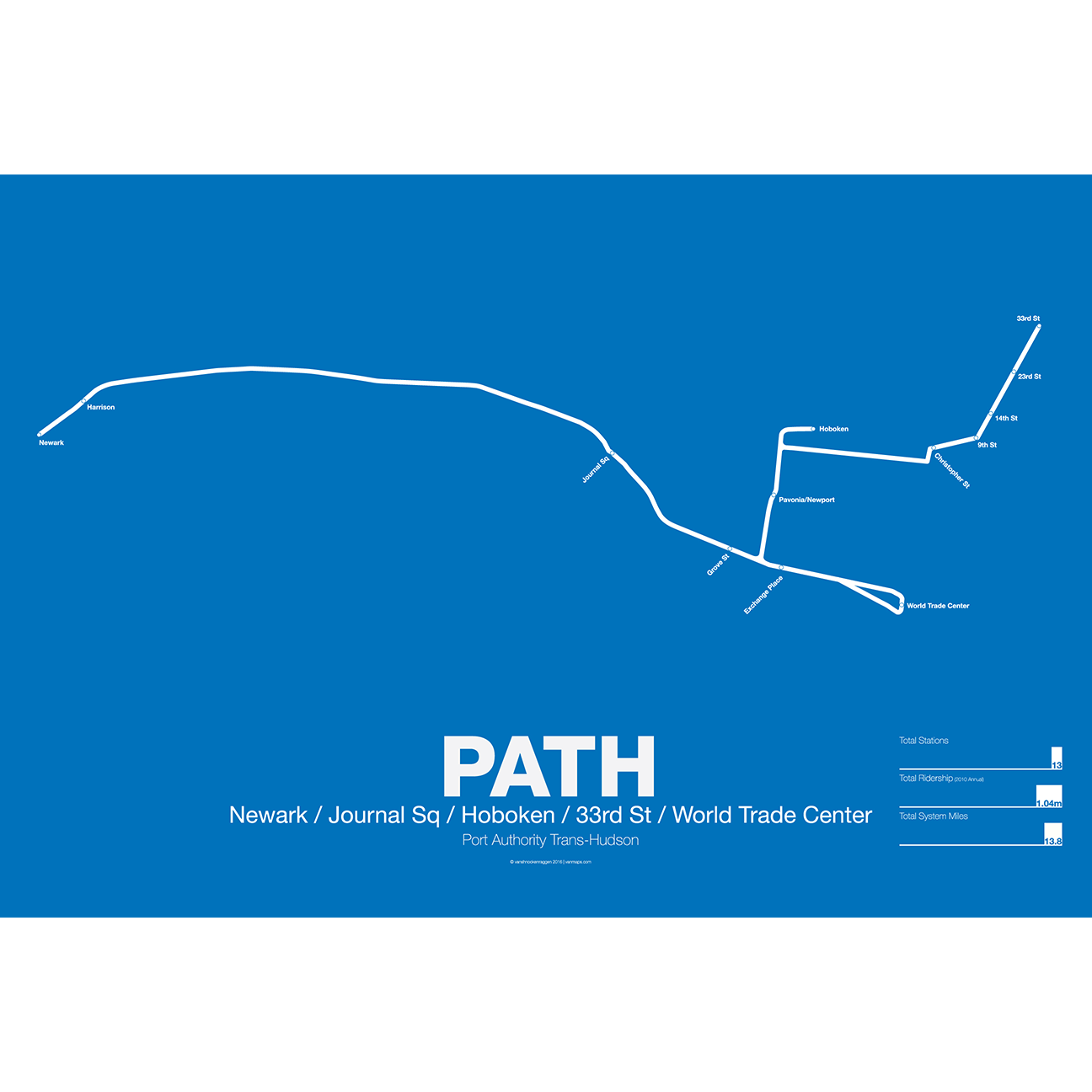
 $30.00 – $80.00
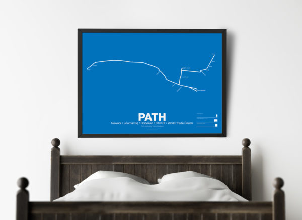
PATH (Port Authority Trans-Hudson), originally known as the Hudson and Manhattan Railroad (H&M), predates the original line of the NYC Subway. First planned in 1874, existing technologies could not safely tunnel under the Hudson River. Construction began on the existing tunnels in 1890, but stopped shortly thereafter when funding ran out. Construction did not resume until 1900 under the direction of William Gibbs McAdoo.
Opened in 1907, the Hudson and Manhattan Railroad tunnels were designed to link three of the major railroad terminals on the Hudson River in New Jersey—the Lackawanna in Hoboken, the Erie and PRR in Jersey City—with New York City. Two sets of tunnels connected commuters to the business centers in lower Manhattan and midtown Manhattan along 6th Ave. As the H&M was opened only 3 years after the original subway extensions were planned from 33rd St to Grand Central (original plans for Grand Central Terminal show space for a never built H&M station) and from 9th St to Astor Pl.
The H&M was only successful for a short 20 years as Pennsylvania Station opened in midtown in 1910 and the Holland Tunnel opened in 1927, diverting rail traffic from New Jersey terminals and then by commuters who chose to drive. Two original stations at 19th St and 28th St were closed to speed up service. By the 1950s the railroad was in bankruptcy but continued to operate. In 1961 the Port Authority was tapped to construct a new World Trade Center in lower Manhattan. In a deal with the states of New York and New Jersey the Port Authority agreed to take over the railroad and moved the location of the new WTC to the Hudson Terminal of the H&M in lower Manhattan. The Port Authority upgraded the system and changed the name to PATH.
Printed on Satin finish 80# cover stock – 220 GSM. Made in the USA! Standard production time is 5 Days. Please add more time for shipping.
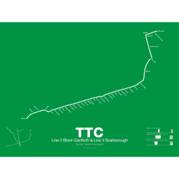
-
 $30.00 – $80.00
Printed on Satin finish 80# cover stock – 220 GSM. Made in the USA! Standard production time is 5 Days. Please add more time for shipping.
-
 $30.00 – $80.00
Printed on Satin finish 80# cover stock – 220 GSM. Made in the USA! Standard production time is 5 Days. Please add more time for shipping.
-
 $30.00 – $80.00
Printed on Satin finish 80# cover stock – 220 GSM. Made in the USA! Standard production time is 5 Days. Please add more time for shipping.
-
 $45.00
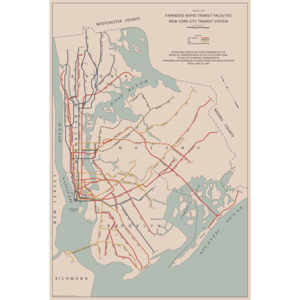
There are two “official” maps of the IND Subway’s expansion plans from the 1930s, colloquially known as the Second System. The plans for expansion evolved greatly as the IND was built. In the 1930s, the New York City subways were still operated by three separate companies. In 1940 the two private companies, the IRT and BMT were purchased by the City of New York under a unification plan. Thus, subway planners were able to imagine physically combining the three systems.
In 1940, John Delaney, Chairman of the Board of Transportation, outlined a new plan, with some additions in 1943. Until now, there were no maps of this plan. So I made one! The 1943 Lost IND Second System Map is probably the last time the city thought about such a large expansion program. The map here is based on the design of the 1939 map, with some changes.
To learn more about the history of this map, and see an outline of the ideas it shows, check out my post.
Printed on Satin finish 80# cover stock – 220 GSM, 24″ x 36″.
-
 $30.00 – $80.00
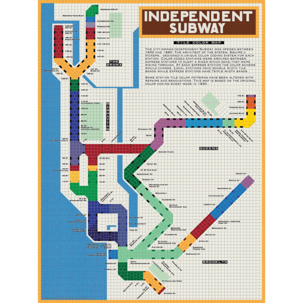
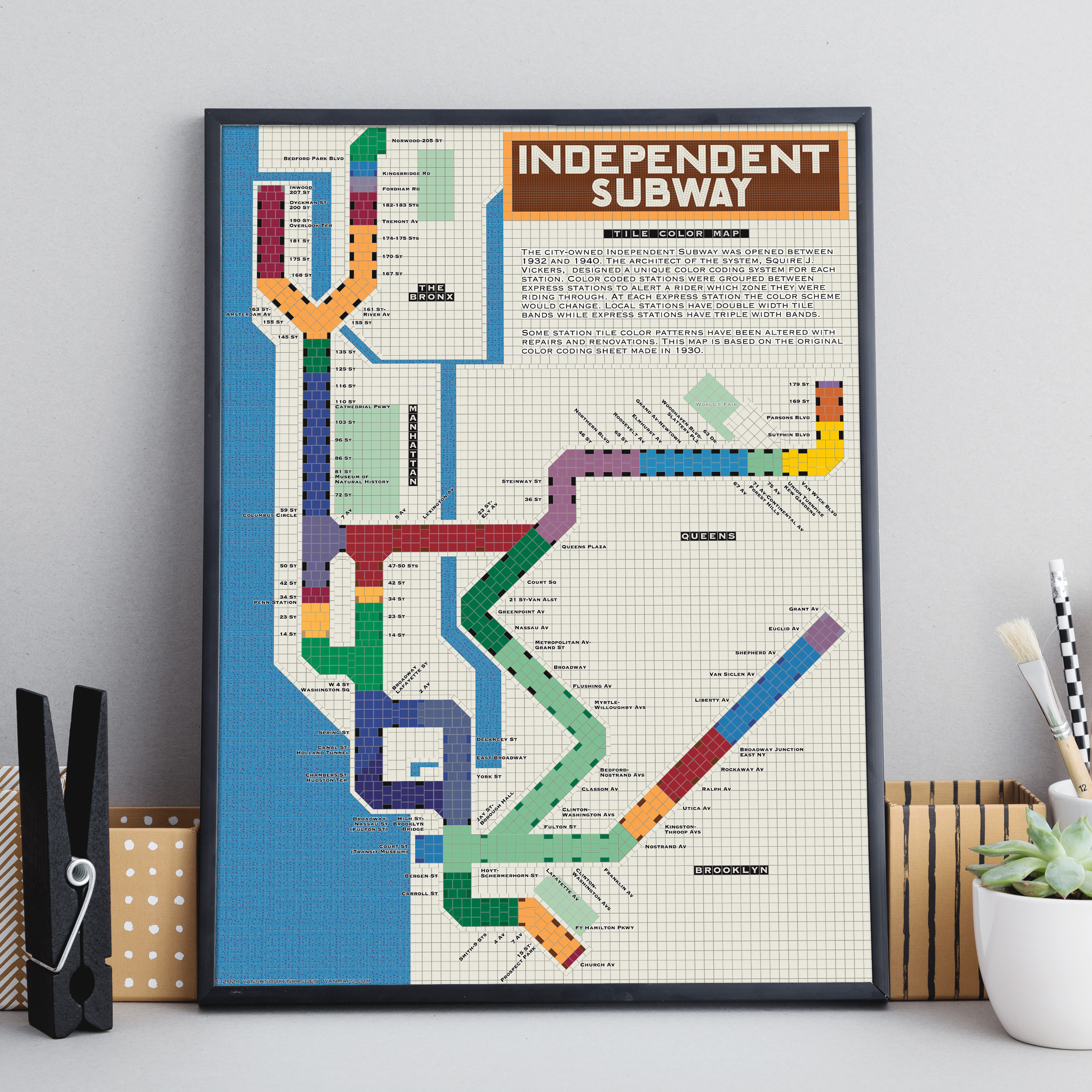
The City of New York built Independent Subway (A/B/C/D/E/F/G trains) was opened between 1932 and 1940. All the subway stations at the time featured tile bands and art unique to each station. The IND’s architect, Squire Vickers, created a new tile pattern based on color theory. He grouped express and local stations with color so that each time a rider rode through an express station the color of the tiles would change. He created a modern, streamlined design which featured two colors per station. The idea was that a rider would recognize their station’s color and know when to get off. This map shows how each color group looks when laid out like a subway map.
Note: The design features an orange tile outline. Some frames may obscure this outline.
Printed on Satin finish 80# cover stock – 220 GSM, 18″ x 24″.
-
 $30.00 – $80.00
Printed on Satin finish 80# cover stock – 220 GSM. Made in the USA! Standard production time is 5 Days. Please add more time for shipping.
-
 $30.00 – $80.00
Printed on Satin finish 80# cover stock – 220 GSM. Made in the USA! Standard production time is 5 Days. Please add more time for shipping.
-
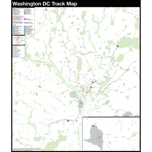
 - 11 % Off
$290.00 – $415.00
- 11 % Off
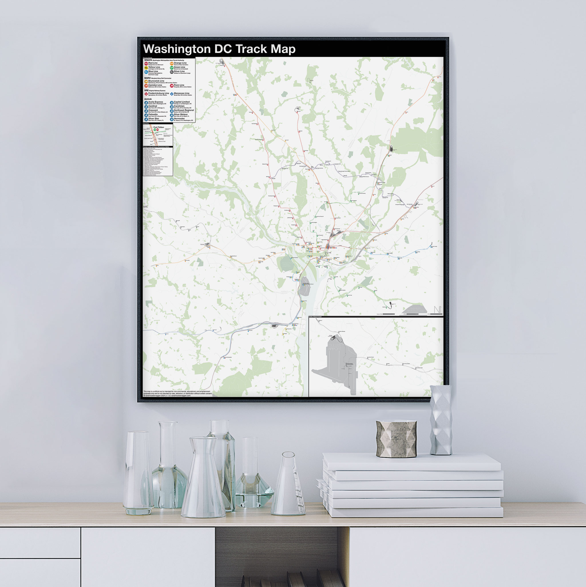
$290.00 – $415.00The Complete and Geographically Accurate track map of Washington DC is a new, detailed look at the entire rail network that most riders never see. Unlike a traditional subway map which just shows train routes, stations, and a simplified geography for easier navigation, the Track Map shows how the system actually looks; each track, each switch, each station platform and each train yard is shown in a clear and clean design. While the Track Map offers a service guide, it is not intended to replace the subway map as a wayfinding tool. The Track Map shows the paths of the tracks so that the viewer can see how trains are able to run. If you’ve ever wondered why certain trains don’t run to certain places, this map will tell you why.
The idea behind this was to remove all distortion from traditional subway maps and see the system down to its bones. Street labels, parks, cemeteries, and airports help act as landmarks. The more complicated interchanges and interlockings are shown in a blown up detail section along with a list of as many provisions and abandoned sections of the system I have discovered.
Fine art prints are made in Williamsburg, Brooklyn NY on Semi-Gloss, 10mil Premium Luster Paper.
-
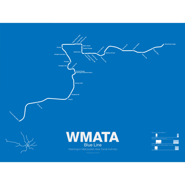 $30.00 – $80.00
The Blue Line was the second section of the Washington Metro to open; on July 1st 1977 trains began running the familiar serpentine route from National Airport through Roslyn and Metro Center (at the time the only transfer station) to Stadium-Armory. In 1978 an extension to New Carrollton opened and service was split between Blue Line trains running from National Airport-New Carrollton and Orange Line trains running the reverse direction. When the Orange Line extension to Ballston opened a year later Blue Line trains were cut back to Stadium-Armory.
When the Addison Road branch opened in 1980 the Blue Line once again ran only one direction while Orange Line trains ran in the other direction, this time on both branches. In 1983 the Yellow Line was opened down to Huntington. This was originally to be the new terminal for Blue Line trains but due to a car shortage the Yellow Line, which required fewer cars, was extended instead, and this service pattern remains to this day. The extension to Van Dorn St (the originally planned terminal for the Yellow Line) didn’t open until 1991 and was extended to Franconia-Springfield in 1997. A final extension to Largo Town Center opened in 2004.
The Blue Line holds the distinction of the line which shares the most amount of track with other lines (the Orange and Yellow lines). In fact during rush hour service only the Arlington Cemetery station is served exclusively by Blue Line trains. Because of this, planners are looking at digging a new tunnel through central D.C. once the Silver Line opens which is also slated to share Blue Line tracks through downtown D.C.
Printed on Satin finish 80# cover stock – 220 GSM. Made in the USA! Standard production time is 5 Days. Please add more time for shipping.
-
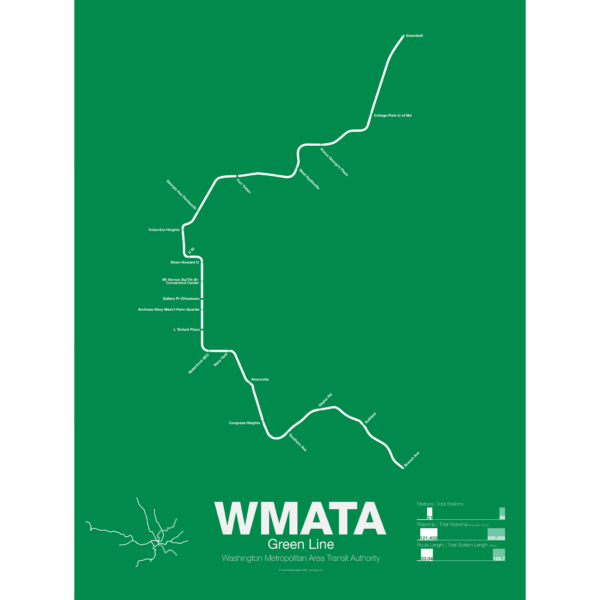 $30.00 – $80.00
The Green Line was the final section of the original Washington Metro to open with trains not running until December 1991. While planning for the Green Line began at the same time as the rest of the system it was decided in 1977 to develop the route last. This decision sparked much controversy because the Green Line runs through areas of the city which are the poorest and most transit dependent.
Legal and funding issues dogged construction of the line. Station locations were also subject to much controversy and the ultimate route changed often. The northern section was to run in the median of the North Central Freeway but had to be changed when the freeway was canceled.
The Green Line shares its route through central D.C. with the Yellow Line. The first section ran from U St to Anacostia. Due to controversy over the route from U St to Fort Totten a small section of the Green Line from Fort Totten to Greenbelt opened first in 1993 with no physical connection to the other section of Green Line.
While the final section of subway from U St to Fort Totten was under construction some Green Line trains ran along the Red Line from West Hyattsville to Farragut North using a single non-revenue track connecting each line. In 1999 the connection between U St and Fort Totten was finally opened. In 2001 the Green Line was extended south to Branch Ave, thus completing the originally planned system 25 years after the first section was opened and 46 years after planning began.
Printed on Satin finish 80# cover stock – 220 GSM. Made in the USA! Standard production time is 5 Days. Please add more time for shipping.
-
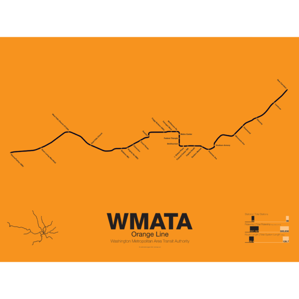 $30.00 – $80.00
The Orange Line was the third leg of the Washington Metro to open, though service began running in 1978 as a one way service along the existing Blue Line from New Carrollton to National Airport. It wasn’t until a year later in 1979 that the Orange Line was extended out to Ballston when it began running in both directions. In 1986 the line was extended out to Vienna. Plans at the time to reroute the line through the fast developing Tysons Corner were eventually dropped to prevent a five year delay in construction.
These plans were resurrected with the Silver Line being built through Tysons Corner on its way to Dulles Airport. The Orange Line through Virginia runs along the median of Interstate 66 from Vienna to Falls Church. Originally the line was to run along the median of I-66 through Arlington but city planners rerouted it through downtown Arlington which helped stimulate dense residential development in central Arlington.
From Roslyn to Stadium-Armory the Orange and Blue lines share their downtown subway tunnel and split after ascending to the surface on a bridge over the Anacostia River. From here the Orange Line runs alongside the CSX/Amtrak ROW to New Carrollton.
Printed on Satin finish 80# cover stock – 220 GSM. Made in the USA! Standard production time is 5 Days. Please add more time for shipping.