map
- Please choose product options by visiting New York City Track Map v2: Complete and Geographically Accurate.
-
 $30.00 – $80.00
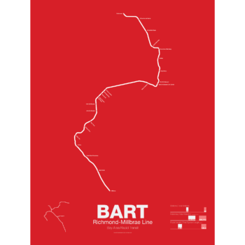
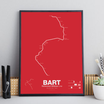
The Bay Area Rapid Transit system (BART) was, along with the WMATA in Washington D.C., one of the great centrally planned post-war rapid transit systems aimed at addressing the rise of the highway and auto-centric suburbs after World War II in the United States. Planning began in the 1950s for a unified high speed rail system that would serve both the dense inner cities of San Francisco and Oakland and their newly expanding low-rise suburbs. Stations would be spaced closer in the central business districts and further out in the suburbs.
Originally planned to connect Alameda, Contra Costa, Marin, San Francisco, and San Mateo counties BART was scaled back when San Mateo dropped out in favor of commuter rail service and the Marin line was dropped due to engineering concerns about running a rail line over the Golden Gate Bridge. Construction began in 1964 and the initial segments began to come online in 1972 and the majority of the system opening by 1974.
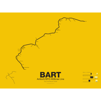
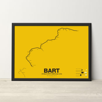
The Pittsburg/Bay Point–SFO/Millbrae Line, also known as the Pittsburg/Bay Point Line or the Concord Line (from the original terminus), was the second line to open in 1973 between Concord and MacArthur stations and extended to Daly City when the Transbay Tube opened in 1974.
In 1995 the line was extended northeast to Pittsburg/Bay Point Point and in 2003 the line was extended south to SFO/Millbrae.
The Pittsburg/Bay Point Line has the distinction of running with the longest train sets in the system; 10 car trains on weekdays and 8 or 9 car trains on evenings and weekends.
The section of track between Concord and Walnut Creek was the site of the BART groundbreaking ceremony in 1964 presided over by President Lyndon B. Johnson. Currently a new eBART system is being built east of Pittsburg/Bay Point station using Diesel Multiple Unit trains (as opposed to electric third-rail trains) to Antioch.
Printed on Satin finish 80# cover stock – 220 GSM. Made in the USA! Standard production time is 5 Days. Please add more time for shipping.
-
 $30.00 – $80.00
The Bay Area Rapid Transit system (BART) was, along with the WMATA in Washington D.C., one of the great centrally planned post-war rapid transit systems aimed at addressing the rise of the highway and auto-centric suburbs after World War II in the United States. Planning began in the 1950s for a unified high speed rail system that would serve both the dense inner cities of San Francisco and Oakland and their newly expanding low-rise suburbs. Stations would be spaced closer in the central business districts and further out in the suburbs.
Originally planned to connect Alameda, Contra Costa, Marin, San Francisco, and San Mateo counties BART was scaled back when San Mateo dropped out in favor of commuter rail service and the Marin line was dropped due to engineering concerns about running a rail line over the Golden Gate Bridge. Construction began in 1964 and the initial segments began to come online in 1972 and the majority of the system opening by 1974.
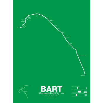
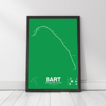
The Fremont-Daly City Line, also known as the Fremont Line, was the third BART line to open starting service in 1974 when the Trans-bay Tube opened. It runs until 7pm on weekdays as service is duplicated by the Dublin/Pleasanton Line and the Richmond-Fremont Line.
Construction has begun on a southern extension to San Jose; the first phase to Warm Springs/South Fremont opened in 2017 with the second phase to Milpitas and Berryessa opened in 2020.
Printed on Satin finish 80# cover stock – 220 GSM. Made in the USA! Standard production time is 5 Days. Please allow more time for shipping.
-
 $30.00 – $80.00
The Bay Area Rapid Transit system (BART) was, along with the WMATA in Washington D.C., one of the great centrally planned post-war rapid transit systems aimed at addressing the rise of the highway and auto-centric suburbs after World War II in the United States. Planning began in the 1950s for a unified high speed rail system that would serve both the dense inner cities of San Francisco and Oakland and their newly expanding low-rise suburbs. Stations would be spaced closer in the central business districts and further out in the suburbs.
Originally planned to connect Alameda, Contra Costa, Marin, San Francisco, and San Mateo counties BART was scaled back when San Mateo dropped out in favor of commuter rail service and the Marin line was dropped due to engineering concerns about running a rail line over the Golden Gate Bridge. Construction began in 1964 and the initial segments began to come online in 1972 and the majority of the system opening by 1974.
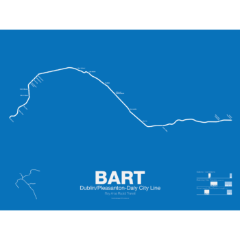
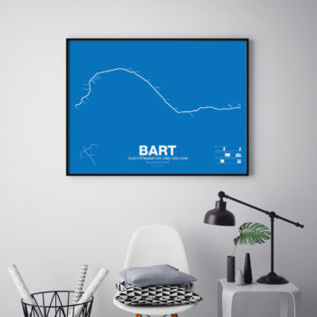
The Dublin/Pleasanton–Daly City Line, also known as the Dublin/Pleasanton Line, is the most recent BART line to open starting service in 1997. Branching off the
Fremont Line in Ashland it runs east along the median of I-580 to Dublin.
Plans are also being discussed to extend the line east to Livermore as either an electric third-rail BART train or Diesel Multiple Unit eBART train.
Printed on Satin finish 80# cover stock – 220 GSM. Made in the USA! Standard production time is 5 Days. Please allow more time for shipping.
-
 $30.00 – $80.00
The Bay Area Rapid Transit system (BART) was, along with the WMATA in Washington D.C., one of the great centrally planned post-war rapid transit systems aimed at addressing the rise of the highway and auto-centric suburbs after World War II in the United States. Planning began in the 1950s for a unified high speed rail system that would serve both the dense inner cities of San Francisco and Oakland and their newly expanding low-rise suburbs. Stations would be spaced closer in the central business districts and further out in the suburbs.
Originally planned to connect Alameda, Contra Costa, Marin, San Francisco, and San Mateo counties BART was scaled back when San Mateo dropped out in favor of commuter rail service and the Marin line was dropped due to engineering concerns about running a rail line over the Golden Gate Bridge. Construction began in 1964 and the initial segments began to come online in 1972 and the majority of the system opening by 1974.
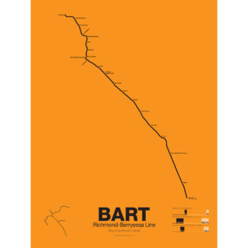
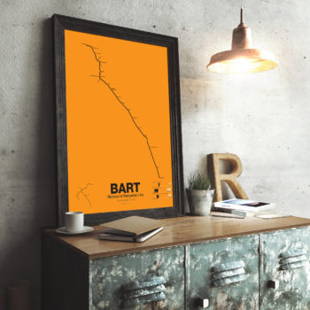
The Richmond-Warm Springs Line, also known as the East Bay Line, is the only line that does not enter San Francisco running from Richmond in the north through Oakland to Fremont in the south. Like most BART lines the Richmond-Fremont Line shares its tracks with other BART lines: the Richmond-Millbrae Line, the Pittsburg/Bay Point–SFO/Millbrae Line, the Fremont–Daly City Line, and the Dublin/Pleasanton–Daly City Line.
The Richmond–Fremont Line was the first of BART’s five lines to open. Service from MacArthur to Fremont began on September 11, 1972, the first day of BART operation and was extended to Richmond on January 29, 1973.
Construction has begun on a southern extension to San Jose; the first phase to Warm Springs/South Fremont opened in 2017 with the second phase to Milpitas and Berryessa opening in 2020.
Printed on Satin finish 80# cover stock – 220 GSM. Made in the USA! Standard production time is 5 days. Allow more time for shipping.
-
 $30.00 – $80.00
The Bay Area Rapid Transit system (BART) was, along with the WMATA in Washington D.C., one of the great centrally planned post-war rapid transit systems aimed at addressing the rise of the highway and auto-centric suburbs after World War II in the United States. Planning began in the 1950s for a unified high speed rail system that would serve both the dense inner cities of San Francisco and Oakland and their newly expanding low-rise suburbs. Stations would be spaced closer in the central business districts and further out in the suburbs.
Originally planned to connect Alameda, Contra Costa, Marin, San Francisco, and San Mateo counties BART was scaled back when San Mateo dropped out in favor of commuter rail service and the Marin line was dropped due to engineering concerns about running a rail line over the Golden Gate Bridge. Construction began in 1964 and the initial segments began to come online in 1972 and the majority of the system opening by 1974.
The Richmond-Millbrae Line, also known as the Richmond Line, was the fourth line to open in the BART system starting limited service in 1976. Because the Richmond Line shares its entire route with other BART lines it stops operations at 8pm on weekdays and 7pm on Saturdays. Originally terminating at Daly City the line was extended south in 2004 to SFO/Millbrae when that extension was opened sharing the line with the Pittsburg/Bay Point–SFO/Millbrae Line.
Printed on Satin finish 80# cover stock – 220 GSM. Made in the USA! Standard production is 5 Days. Please allow more time for shipping.
-
 $30.00 – $80.00
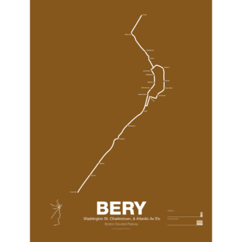
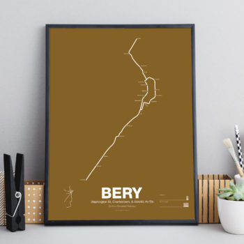
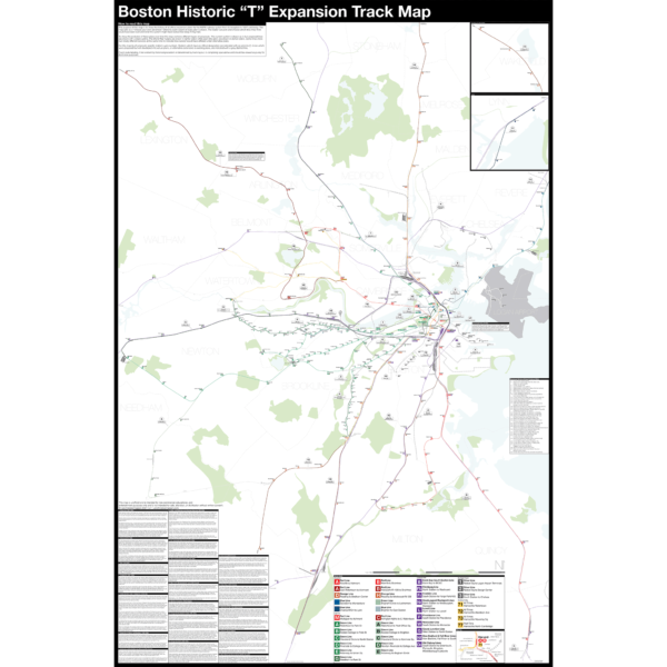
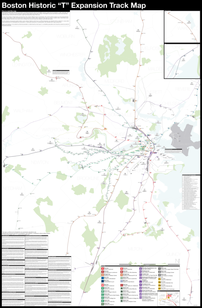
What is today the Orange Line was part of the original Boston Elevated Railway subway and elevated network. Today the only section remaining is the Washington St Tunnel from Haymarket to Chinatown. Originally there were two lines through downtown: the Main Line and the Atlantic Ave El. The Main Line served elevated branches from Charlestown and along Washington St to Dudley Sq. in the South End. The Atlantic Ave El ran from Castle Sq. in the South End to North Station along Atlantic Ave to serve the maritime industries along the waterfront.
As the city grew so did the elevated lines, being extended to Forest Hills and Everett (a further extension to Malden was halted until the 1970s). As the maritime industry faded and ridership dropped the Atlantic Ave El was demolished and sold for scrap during World War II.
While the El served the city well it was not popular as it was loud, dark, and dirty. Plans were laid as early as 1945 to remove the El and rebuild as a subway.
In the 1970s the city canceled ambitious plans to run highways through and around the city and monies were transferred to subway construction. The northern section was rebuilt first, removing the elevated tracks through Charlestown and moving them west along a new subway to Malden in 1975.
The southern section was rebuilt along the route for the canceled I-95 expressway through Jamaica Plain to Forest Hills in 1987. While the new Orange Line was modern and fast the new route bypassed the existing community of Roxbury which relied heavily on mass transit. Service along the old route was replaced by the Silver Line bus in 2002.
Printed on Satin finish 80# cover stock – 220 GSM. Made in the USA! Standard production time is 5 Days. Please add more time for shipping.
-
 $375.00 – $500.00
Boston opened the first subway in the US in 1897 and immediately began expanding it. Since then numerous plans have been drawn up, some are simple extensions while others are whole sale reimaginations of the subway. This map shows in detail each official proposal with the history of each idea.
The map acts as a “choose your own adventure” where by each variant of every plan is drawn. The reader can pick and choose which lines they think could have been built and what the system might have looked like today if they had.
Fine art prints are made in Williamsburg, Brooklyn NY on Semi-Gloss, 10mil Premium Luster Paper.
For more information about the map see the original blog post here.
-
 $325.00 – $450.00
NEW version 3 with Green Line Extension!
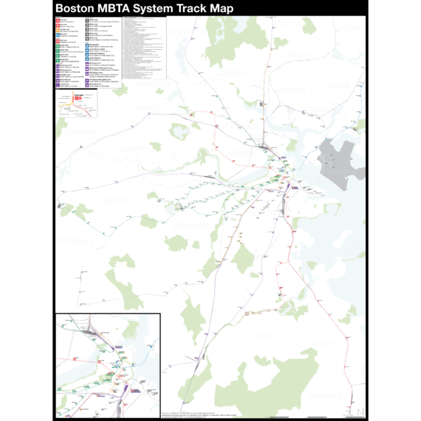
The Complete and Geographically Accurate Boston MBTA Subway Track Map is a new detailed look at the subway system that most riders never see. Unlike a traditional subway map which just shows train routes, stations, and a simplified geography for easier navigation, the Track Map shows how the system actually looks; each track, each switch, each station platform and each train yard is shown in a clear and clean design. While the Track Map offers a service guide it is not intended to replace the subway map as a wayfinding tool. The Track Map shows the paths of the tracks so that the viewer can see how trains are able to run. If you’ve ever wondered why certain trains don’t run to certain places this map will tell you why.
The idea behind this was to remove all distortion from traditional subway maps and see the system down to its bones. Street labels, parks, cemeteries, and airports help act as landmarks. The more complicated interchanges and interlockings are shown in a blown up detail section along with a list of as many provisions and abandoned sections of the system I have discovered.
Fine art prints are made in Williamsburg, Brooklyn NY on Semi-Gloss, 10mil Premium Luster Paper.
For more information about the map see the original blog post here.
-
 $30.00 – $80.00
Printed on Satin finish 80# cover stock – 220 GSM. Made in the USA! Standard production time is 5 days. Allow more time for shipping.
-
 $375.00 – $500.00
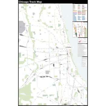
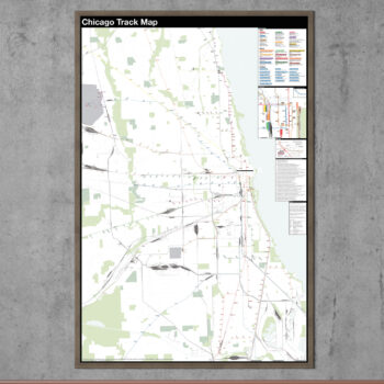
The Complete and Geographically Accurate track map of Chicago is a new detailed look at the entire rail network that most riders never see. Unlike a traditional subway map which just shows train routes, stations, and a simplified geography for easier navigation, the Track Map shows how the system actually looks; each track, each switch, each station platform and each train yard is shown in a clear and clean design. While the Track Map offers a service guide it is not intended to replace the subway map as a wayfinding tool. The Track Map shows the paths of the tracks so that the viewer can see how trains are able to run. If you’ve ever wondered why certain trains don’t run to certain places this map will tell you why.
The idea behind this was to remove all distortion from traditional subway maps and see the system down to its bones. Street labels, parks, cemeteries, and airports help act as landmarks. The more complicated interchanges and interlockings are shown in a blown up detail section along with a list of as many provisions and abandoned sections of the system I have discovered.
Fine art prints are made in Williamsburg, Brooklyn NY on Semi-Gloss, 10mil Premium Luster Paper.
For more information about the map see the original blog post here.
-
 $30.00 – $80.00
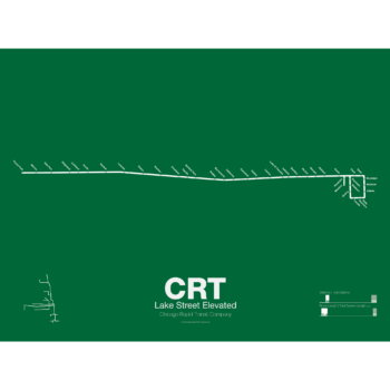
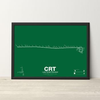
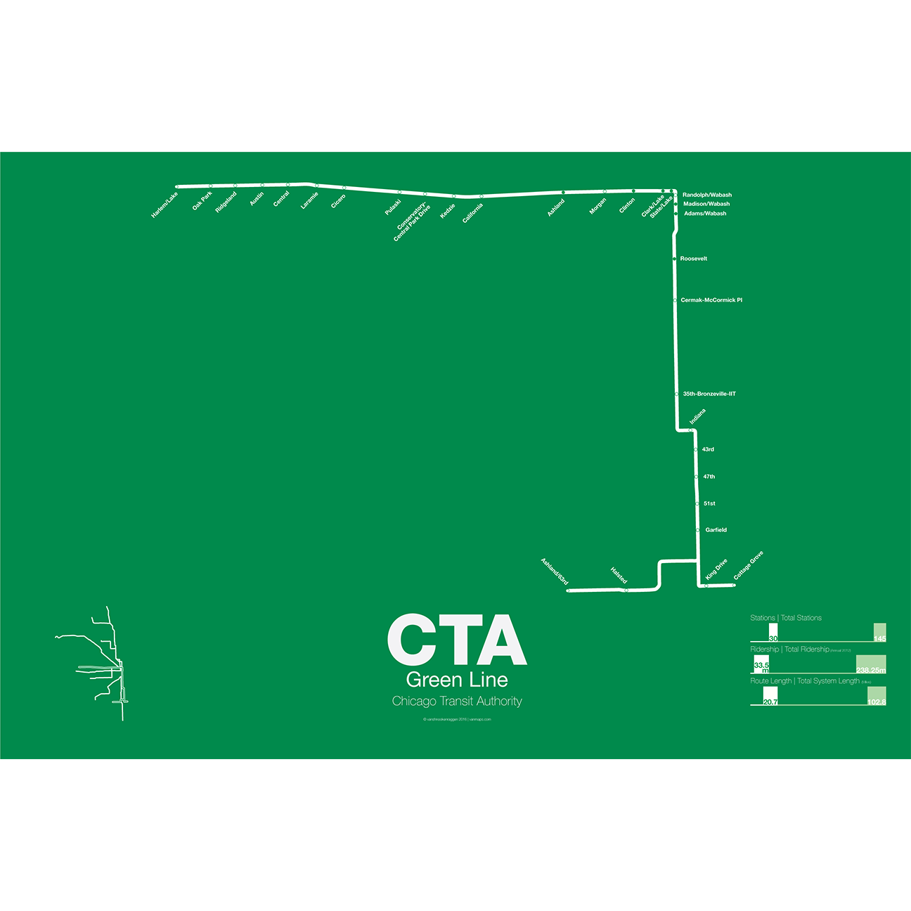
The Lake Street Elevated was Chicago’s second elevated line opening in 1893. In 1993 the CTA reorganized routes and color coded the new Lake St-South Side Lines as the Green Line.
Printed on Satin finish 80# cover stock – 220 GSM. Made in the USA! Standard production time is 5 Days. Please add more time for shipping.
-
 $30.00 – $80.00
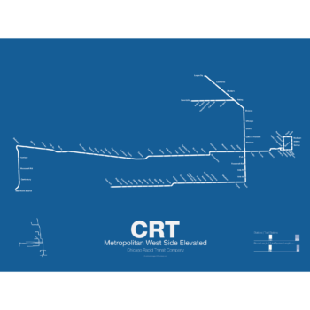
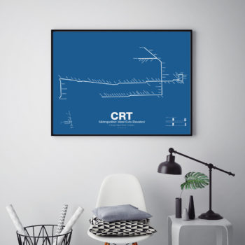
In 1895 the Metropolitan West Side Elevated Railroad began with service from Canal St to Logan Sq. Soon branches were added to Garfield Park, Humboldt Park, and Douglas Park. The Met, as it was known, has seen the most dramatic changes of all the Chicago “L” lines: the Humboldt Park and Logan Sq branches were removed when service was rerouted through the new Milwaukee-Dearborn Subway in 1951 and subsequently extended along the Kennedy Expressway to Jefferson Park in 1970 and then to O’Hare Airport in 1984. The Garfield Park branch was completely rebuilt along the median of Interstate 290 in 1958. In 2008 the Douglas Branch was rerouted along the Paulina Connector (a left over section of track from the old Logan Sq branch) to connect to the Loop and rebranded as the Pink Line.
Printed on Satin finish 80# cover stock – 220 GSM. Made in the USA! Standard production time is 5 Days. Please add more time for shipping.
-
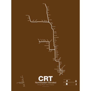
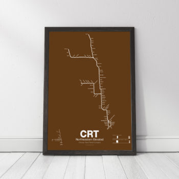 $30.00 – $80.00
The Northwestern Elevated opened in 1907 and ran from a terminal on North Water St before it connected to Loop. The Main Line ran north to Evanston and a branch was built to Kimball. When the Northwestern was consolidated into the Chicago Rapid Transit Commission a second branch to Skokie was connected which once allowed interurban trains to run from the Loop to Milwaukee. The Northwestern division was split into the Brown, Purple, Yellow, and Red Lines.
Printed on Satin finish 80# cover stock – 220 GSM. Made in the USA! Standard production time is 5 Days. Please add more time for shipping.
-
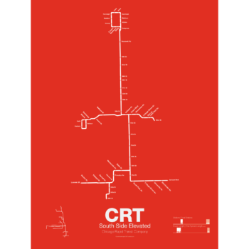
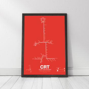 $30.00 – $80.00
The South Side elevated opened in 1892 to serve the Columbian Exposition in 1893 and led to a building boom on the south side of Chicago. A number of branches were added to the line, to Englewood, Normal Park, Kenwood, and the Stock Yards. Today only the Englewood and Jackson Park branches remain while a number of stations have been closed due to low ridership.
Printed on Satin finish 80# cover stock – 220 GSM. Made in the USA! Standard production time is 5 Days. Please add more time for shipping.
-
 $30.00 – $80.00
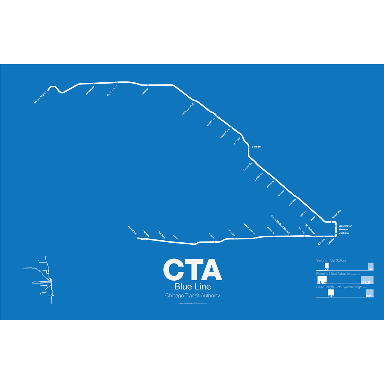
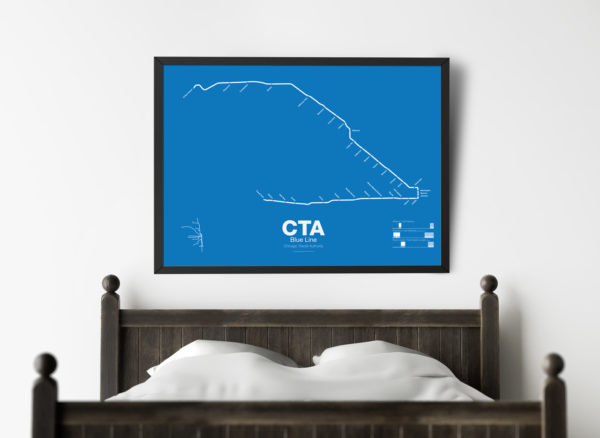
What today is the Blue Line started in 1895 as the Metropolitan West Side Elevated Railroad with service from Canal St to Logan Sq. Soon branches were added to Garfield Park, Humboldt Park, and Douglas Park. The Met, as it was known, has seen the most dramatic changes of all the Chicago “L” lines: the Humboldt Park and Logan Sq branches were removed when service was rerouted through the new Milwaukee-Dearborn Subway in 1951 and subsequently extended along the Kennedy Expressway to Jefferson Park in 1970 and then to O’Hare Airport in 1984. The Garfield Park branch was completely rebuilt along the median of Interstate 290 in 1958. In 2008 the Douglas Branch was rerouted along the Paulina Connector (a left over section of track from the old Logan Sq branch) to connect to the Loop and rebranded as the Pink Line.
The modern sections of the Blue Line were the first examples of rapid transit running along a high median in the US. The Blue Line, along with the Red Line, are the only two services of the CTA which run 24 hours a day.
Printed on Satin finish 80# cover stock – 220 GSM. Made in the USA! Standard production time is 5 Days. Please add more time for shipping.
-
 $30.00 – $80.00
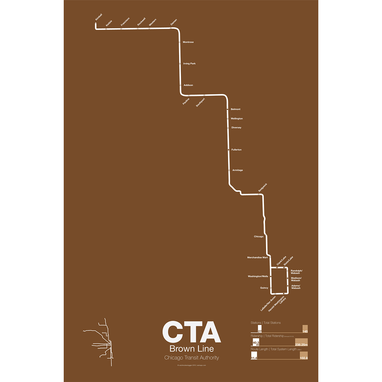
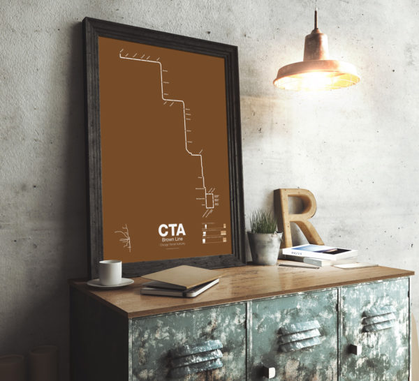
The Brown Line began as the Northwestern Elevated in 1907 and runs from its terminal at Kimball to the Loop and back, making a zig-zag through the northwest section of the city. At the terminal at Kimball trains run at street level with third-rail power which is rare for transit in the US and extremely dangerous for pedestrians. Brown Line trains run local with Red Line trains from Belmont to Fullerton. Recently the stations of the Brown Line were expanded and upgraded to be ADA compliant to deal with rapid population growth on the north side.
Printed on Satin finish 80# cover stock – 220 GSM. Made in the USA! Standard production time is 5 Days. Please add more time for shipping.
-
 $30.00 – $80.00
The Green Line is the modern combination of two of the oldest sections of the Chicago “L”. The South Side elevated opened in 1892 to serve the Columbian Exposition in 1893 and led to a building boom on the south side of Chicago. A number of branches were added to the line, to Englewood, Normal Park, Kenwood, and the Stock Yards. Today only the Englewood and Jackson Park branches remain while a number of stations have been closed due to low ridership.
The Lake St elevated was Chicago’s second elevated line opening in 1893. When the State St Subway opened in 1947 it was originally used by the South Side trains to connect to the north side and when the Dan Ryan Branch opened in 1969 it was used by the Lake St Line. In 1993 the CTA reorganized routings and color coded the new Lake St-South Side Lines as the Green Line.
Printed on Satin finish 80# cover stock – 220 GSM. Made in the USA! Standard production time is 5 Days. Please add more time for shipping.
-
 $30.00 – $80.00
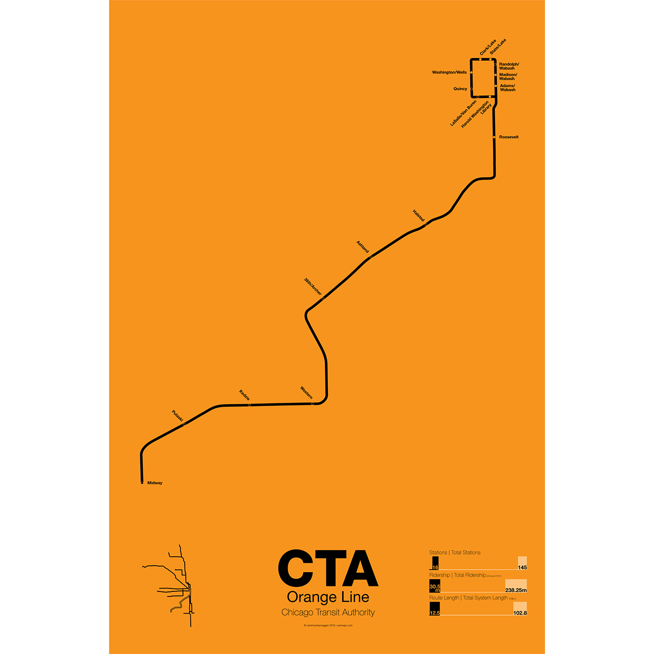
First proposed in the 1930s but only opened in 1993 the Orange Line serves the southwest section of Chicago and terminates at Midway Airport. Funding for the line was secured after the cancellation of the controversial Crosstown Expressway. For much of the route the Orange Line runs parallel to CSX and Conrail tracks but connects to the Loop in downtown Chicago. The original terminal at Ford City Mall was cut back due to cost savings but current studies are underway to extend the Orange Line past Midway to the mall.
Printed on Satin finish 80# cover stock – 220 GSM. Made in the USA! Standard production time is 5 Days. Please add more time for shipping.
-
 $30.00 – $80.00
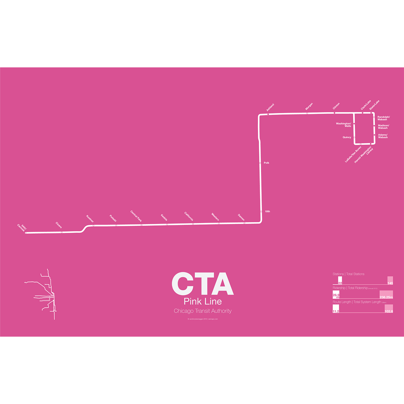
The Pink Line is the most recent addition to the CTA but uses some of the original tracks of the old Metropolitan West Side elevated. The Douglas Park branch opened in 1896 and ran as far west as Oak Park Ave until it was cut back to 54th Ave in Cicero. When the Garfield Park branch of the Met was removed and replaced by the Congress Line (running in the median of Interstate 290) the Douglas Park branch was connected to it and routed through the Milwaukee-Dearborn Subway.
The Congress-Douglas Lines operated a skip-stop service with stations being designated as A, B, or A/B. The Douglas branch ran B trains exclusively until this service was discontinued. In 2005 the CTA began studies looking at making the Douglas branch a separate line, originally known as the Silver Line. In 2006 a contest found that pink was the preferred choice. The CTA rehabilitated a section of track known as the Paulina Connector which was part of the original Metropolitan elevated but was connected to the Lake St Line. This allows Douglas branch trains to run over the Loop for the first time in half a century.
Printed on Satin finish 80# cover stock – 220 GSM. Made in the USA! Standard production time is 5 Days. Please add more time for shipping.
-
 $30.00 – $80.00
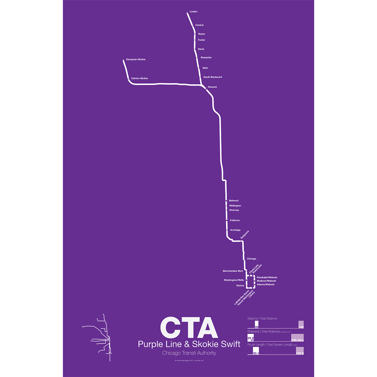
The Purple Line began as part of the Northwestern elevated, a bit of a misnomer as the line ran mostly at street level until it was expanded onto a 4 track elevated embankment in 1928. The line was extended to Evanston in 1908 and Wilmette in 1912. After 1928 the line began running express from Howard station to the Loop. In 1949 when the CTA took over operations the line was rerouted through the State St Subway as part of a new north-south route. This service was eventually replaced by the Red Line. Today the Purple Line runs from Linden to Howard days and express to the Loop at rush hour.
The Yellow Line, formerly known as the Skokie Swift, began as an interurban high speed line from Howard terminal to Dempster St in Niles Center (now known as Skokie). The line ceased operations in 1963 but was bought by the CTA and service restarted in 1964 with intermediate stations closed. The Yellow Line is the only line in the CTA which doesn’t run to downtown Chicago. In 2012 an infill station at Oakton was opened and a northern extension to Old Orchard Mall is being studied.
Printed on Satin finish 80# cover stock – 220 GSM. Made in the USA! Standard production time is 5 Days. Please add more time for shipping.