manhattan
-
 $30.00 – $80.00
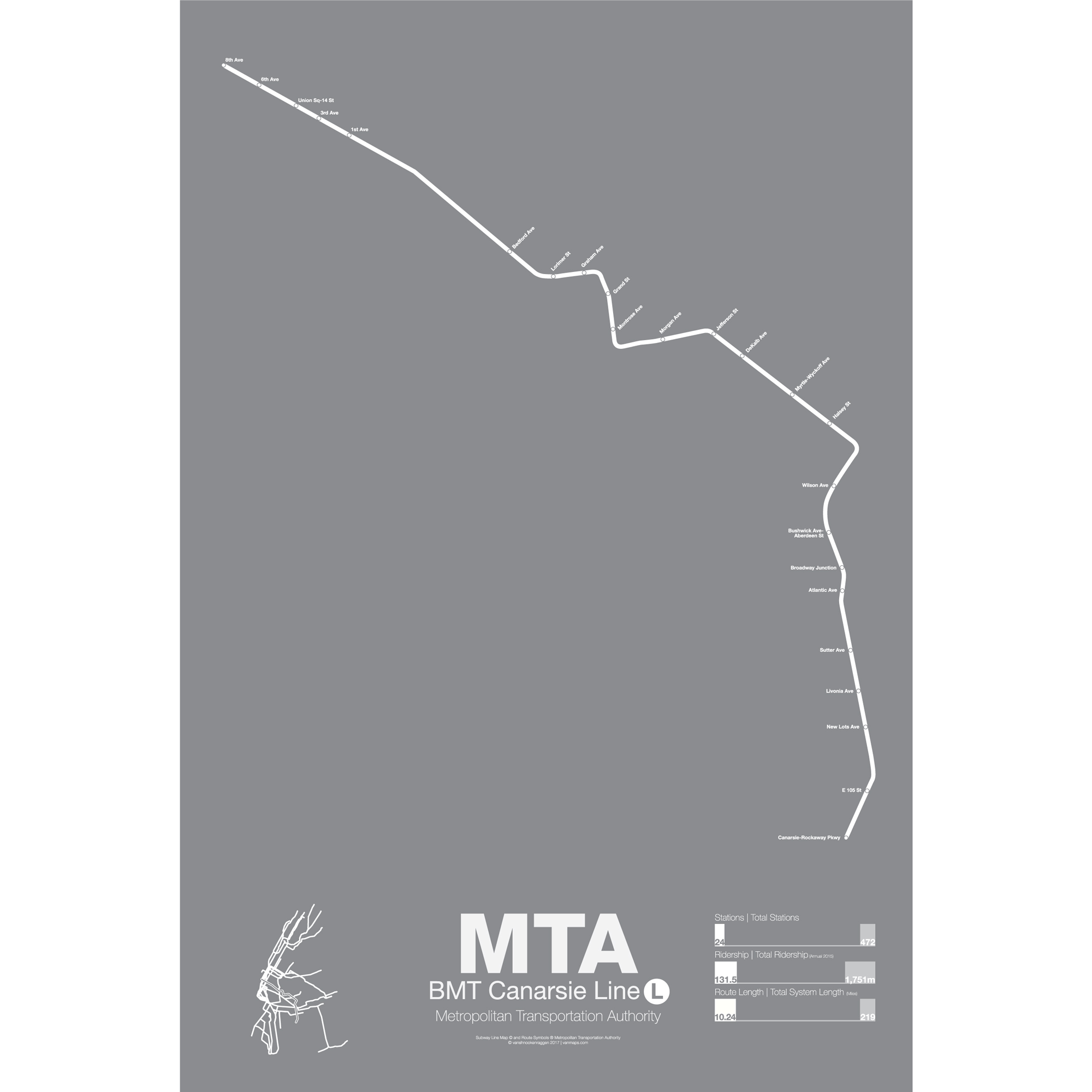
The BMT Canarsie line started its life, like most other Brooklyn lines, as a steam railroad. From Brooklyn Junction to Canarsie it ran until 1906 when it was added to the expanding elevated rail network. Service ran from Williamsburg to Canarsie along the still existing Broadway elevated line. In 1924 the 14th St section in Manhattan opened running from 6th Ave into Williamsburg, making a zig zag through Bushwick and meeting up with the tail end of the elevated line to Canarsie.
The line has only one train, the L, which runs local all times. Original service patterns had trains running to from 14th St/8th Ave (added when the IND 8th Ave line was built) to Canarsie and 14th St/8th Ave to Lefferts Blvd. The Lefferts Blvd branch was suspended when the Fulton St elevated was demolished.
Because the Canarsie line only runs one train line and is separate from other lines it is often used as a testing ground for new technologies. Automated trains, new train cars, and service countdown clocks have all been added and tested on the Canarsie line before being expanded to other lines.
Printed on Satin finish 80# cover stock – 220 GSM. Made in the USA! Standard production time is 5 days. Allow more time for shipping.
-
 $30.00 – $80.00
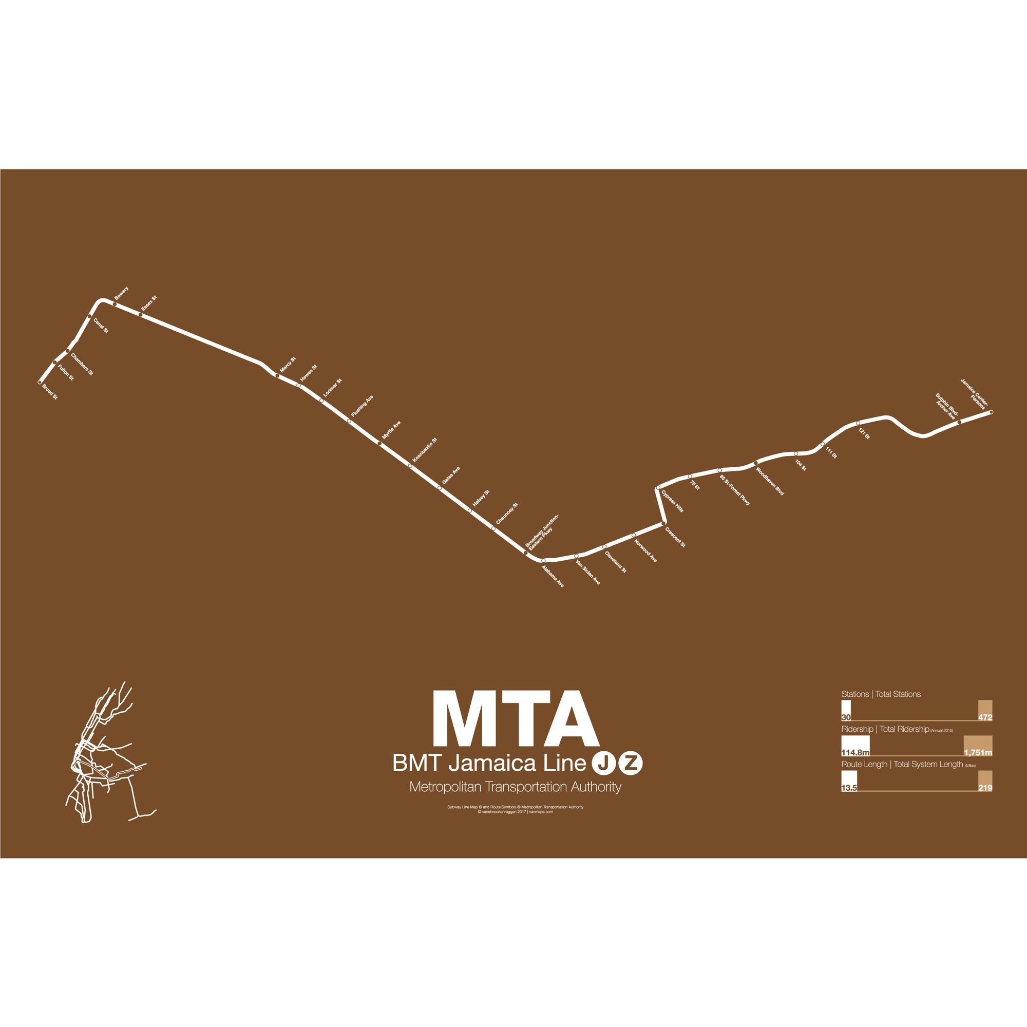
The BMT Jamaica line is the second oldest continually operated rapid transit line in all of New York City (behind the Franklin Ave shuttle). Originally an elevated train from Driggs Ave in Williamsburg to Gates Ave where it connected with the existing Lexington Ave elevated (not to be confused with the Lexington Ave subway in Manhattan). Opened in 1885 the line was electrified and expanded east to Broadway Junction (1893) then to Jamaica (1913). When the Williamsburg Bridge opened in 1903 it was extended to an underground terminal at Delancey and Essex St on the Lower East Side.
In 1918 a subway was opened connecting the existing terminal at Essex St to a new terminal downtown at Chambers St under the newly constructed Municipal Building. While the elevated line in Brooklyn was only 3 tracks (2 in many places) the new subway under Delancey and Centre Sts was 4 tracks and allowed for express service. The subway was further extended to connect to the new BMT Broadway line subway for service back into Brooklyn.
Three trains run along the BMT Jamaica line. The J/Z runs local from Broad St in Manhattan weekdays (rush hours) and Chambers St all other times to Marcy Ave. After Marcy Ave at rush periods the J runs express to Myrtle Ave and Broadway Junction (running local all other times). After Broadway Junction the J and Z trains operate “skip-stop” service where each train alternates stops. Thus each train only stops at half of the stations. The original elevated track through Jamaica Center was demolished in the 1979 and service was rerouted along the new subway under Archer Ave.
M trains once ran along an elevated line, the Myrtle Ave elevated, from downtown Brooklyn out to Middle Village-Metropolitan Ave. In the 1950s the section of track from downtown to Broadway (Brooklyn) was torn down and service was run from Broad St to Middle Village along the northern portion of the tracks. The M train made this run until 2010 when it was rerouted through the Chrystie St cut to run as local service along 6th Ave. On nights and on weekends the M train is cut back to a shuttle service from Myrtle Ave to Middle Village.
Printed on Satin finish 80# cover stock – 220 GSM. Made in the USA! Standard production time is 5 days. Allow more time for shipping.
-
 $30.00 – $80.00
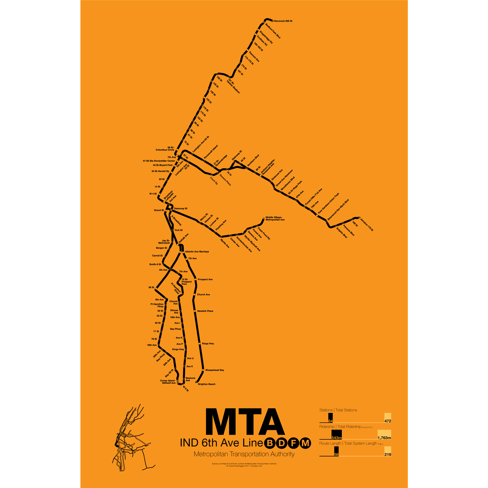
The 6th Ave Line was the second half of the original IND system in Manhattan. The subway was built to replace the old 6th Ave elevated trains and, unlike the 8th Ave Line, was opened in sections between 1936 and 1968. The original sections expanded on the recently opened 8th Ave Line along Houston St to East Broadway, then under 6th Ave from West 4th St to 53rd St. The main trunk subway along 6th Ave was originally built with only two local tracks because of the existing PATH running under 6th Ave. Express tracks were not built until 1967.
B trains run only weekdays from 145th St in Manhattan to Brighton Beach via the Manhattan Bridge and the Brighton Line. At peak times B trains are extended into the Bronx to Bedford Park Blvd. D trains run all times from Norwood-205th St in the Bronx to Coney Island via the Manhattan Bridge, 4th Ave subway, and West End line (elevated). At peak times D trains run express along the Concourse subway. Both B and D trains run express in Manhattan, though B trains make all local stops from 59th St-Columbus Circle to 145th St.
F trains run express along the Queens Blvd subway and enter Manhattan via the 63rd St subway built in the 1960s as a part of the 2nd Ave subway. In Manhattan and Brooklyn F trains run local at all times. In Brooklyn the F shares part of its route with the IND G Crosstown line to Church Ave. After Church Ave the subway becomes elevated to Coney Island.
M trains once ran along the BMT Jamaica line to downtown Manhattan but in 2010 were rerouted along 6th Ave to Forest Hills replacing the short lived V train (which ran from Forest Hills to 2nd Ave). Elevated in Brooklyn, the M train runs through a section of tunnel, built in the 1960s but rarely used, to connect the 6th Ave line to the Williamsburg Bridge. M trains run all local weekdays and as a shuttle from Myrtle Ave to Middle Village nights and weekends.
Printed on Satin finish 80# cover stock – 220 GSM. Made in the USA! Standard production time is 5 days. Allow more time for shipping.
-
 $30.00 – $80.00
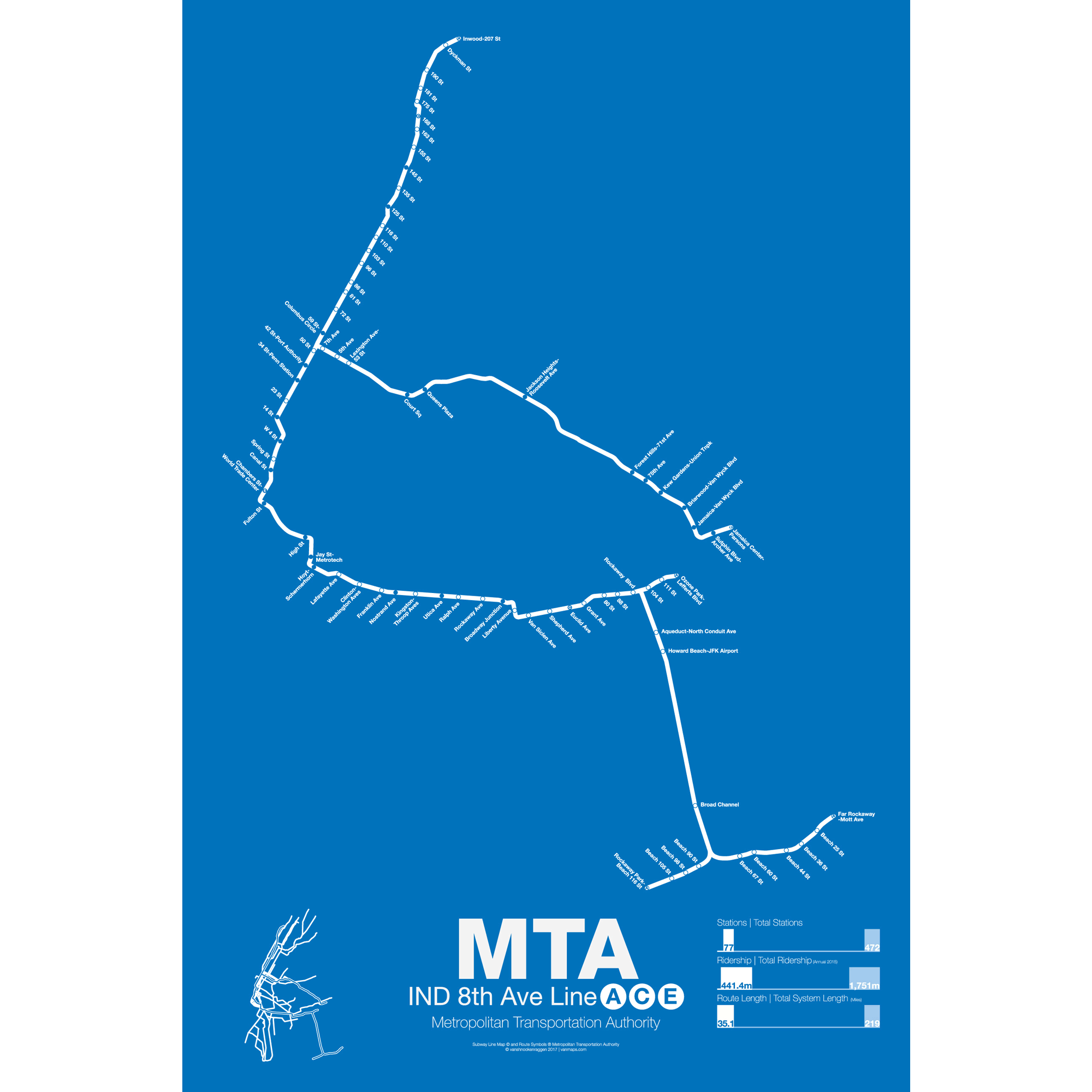
The 8th Ave Line was the first section to open as part of the Independent Subway (IND), a new system built and operated by the City of New York to compete with the privately run IRT in Manhattan and the Bronx and the BMT in Brooklyn and under Broadway. The first major section opened in September 1932 with express and local service from Washington Heights to Chambers St.
The 8th Ave Line shares its tracks with the 6th Ave trains along Central Park West and 53rd St. The A train (made famous by Billy Strayhorn’s Take the A Train) runs from 207th St in Inwood to Fulton St in downtown Manhattan as express while the C train runs all local from 168th St in Washington Heights to Fulton St. From there the line enters Brooklyn and runs out to Ozone Park along the Fulton St subway (not to be confused with Fulton St in Manhattan). The C train terminates at Euclid Ave while the A train continues on to one of three termini: Lefferts Blvd, Rockaway Park and Far Rockaway. The A is the only train with multiple, regular service, termini.
The E train runs local in Manhattan from World Trade Center to 50th St where it splits from 8th Ave under 53rd St heading east into Long Island City and Queens Plaza. The E train is one of the two workhorse express trains running along the Queens Blvd subway to Forest Hills and Jamaica. The E splits from the Queens Blvd subway at Van Wyck Ave and terminates in Jamaica Center.
The majority of the 8th Ave Line is underground and was built specifically for the IND system. The sections of elevated track after Euclid Ave to Lefferts Blvd were recaptured from the existing Fulton St elevated line in the 1940s and the tracks out to the Rockaways where added in the 1950s after being purchased from the Long Island Rail Road.
Printed on Satin finish 80# cover stock – 220 GSM. Made in the USA! Standard production time is 5 days. Allow more time for shipping.
-
 $375.00 – $500.00
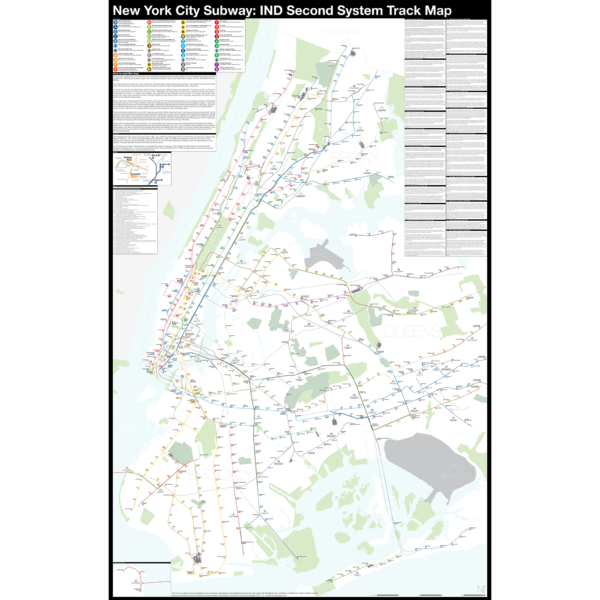
The Independent City-owned Subway System, IND, was created as alternative to the private traction companies, Interborough Rapid Transit Co., IRT, and the Brooklyn-Manhattan Transit Co., BMT. The IND broke ground on the 8th Ave Line in 1925 with plans for lines to Queens, Brooklyn, and the Bronx. In 1929 the IND released an ambitious plan for expanding the initial system. This plan became known as the IND Second System. In 1940 the City of New York was able to purchase the private companies and combine all three systems under the NYC Board of Transportation. In 1953 this evolved into the NY Transit Authority and in 1968 the state took control of the subways as part of the Metropolitan Transportation Authority.
The purpose of this map is the show the history of official subway expansion plans which can be broadly broken down into four phases: the 1929 Second System plan, the 1939 Second System plan, post-World War II plans, and the 1968 MTA Plan for Action.
The map acts as a “choose your own adventure” where by each variant of every plan is drawn. The reader can pick and choose which lines they think could have been built and what the system might have looked like today if they had.
Fine art prints are made in Williamsburg, Brooklyn NY on Semi-Gloss, 10mil Premium Luster Paper.
For more information about the map see the original blog post here.
-
 $375.00 – $500.00
NEW version 2!
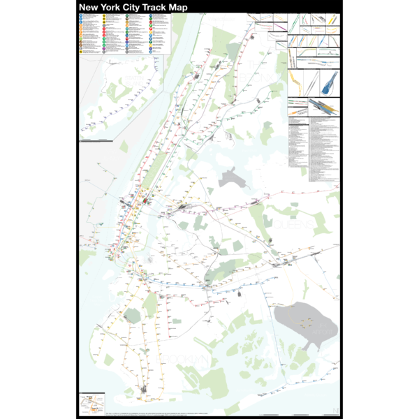
The Complete and Geographically Accurate New York City Track Map is a new detailed look at the entire rail network that most riders never see. Unlike a traditional subway map which just shows train routes, stations, and a simplified geography for easier navigation, the Track Map shows how the system actually looks; each track, each switch, each station platform and each train yard is shown in a clear and clean design. While the Track Map offers a service guide it is not intended to replace the subway map as a wayfinding tool. The Track Map shows the paths of the tracks so that the viewer can see how trains are able to run. If you’ve ever wondered why certain trains don’t run to certain places this map will tell you why.
The idea behind this was to remove all distortion from traditional subway maps and see the system down to its bones. Street labels, parks, cemeteries, and airports help act as landmarks. The more complicated interchanges and interlockings are shown in a blown up detail section along with a list of as many provisions and abandoned sections of the system I have discovered.
Fine art prints are made in Williamsburg, Brooklyn NY on Semi-Gloss, 10mil Premium Luster Paper.
For more information about the map see the original blog post here.