green line
-
 $30.00 – $80.00
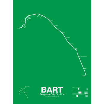
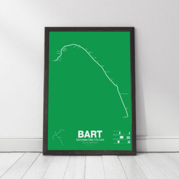
The Bay Area Rapid Transit system (BART) was, along with the WMATA in Washington D.C., one of the great centrally planned post-war rapid transit systems aimed at addressing the rise of the highway and auto-centric suburbs after World War II in the United States. Planning began in the 1950s for a unified high speed rail system that would serve both the dense inner cities of San Francisco and Oakland and their newly expanding low-rise suburbs. Stations would be spaced closer in the central business districts and further out in the suburbs.
Originally planned to connect Alameda, Contra Costa, Marin, San Francisco, and San Mateo counties BART was scaled back when San Mateo dropped out in favor of commuter rail service and the Marin line was dropped due to engineering concerns about running a rail line over the Golden Gate Bridge. Construction began in 1964 and the initial segments began to come online in 1972 and the majority of the system opening by 1974.
The Fremont-Daly City Line, also known as the Fremont Line, was the third BART line to open starting service in 1974 when the Trans-bay Tube opened. It runs until 7pm on weekdays as service is duplicated by the Dublin/Pleasanton Line and the Richmond-Fremont Line.
Construction has begun on a southern extension to San Jose; the first phase to Warm Springs/South Fremont opened in 2017 with the second phase to Milpitas and Berryessa opened in 2020.
Printed on Satin finish 80# cover stock – 220 GSM. Made in the USA! Standard production time is 5 Days. Please allow more time for shipping.
-
 $375.00 – $500.00
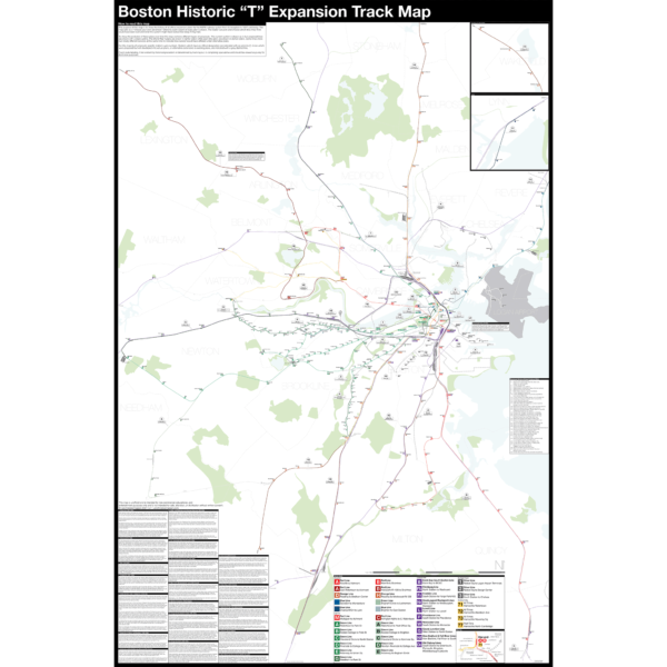
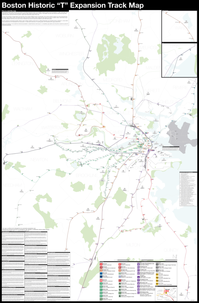
Boston opened the first subway in the US in 1897 and immediately began expanding it. Since then numerous plans have been drawn up, some are simple extensions while others are whole sale reimaginations of the subway. This map shows in detail each official proposal with the history of each idea.
The map acts as a “choose your own adventure” where by each variant of every plan is drawn. The reader can pick and choose which lines they think could have been built and what the system might have looked like today if they had.
Fine art prints are made in Williamsburg, Brooklyn NY on Semi-Gloss, 10mil Premium Luster Paper.
For more information about the map see the original blog post here.
-
 $30.00 – $80.00
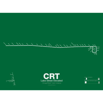
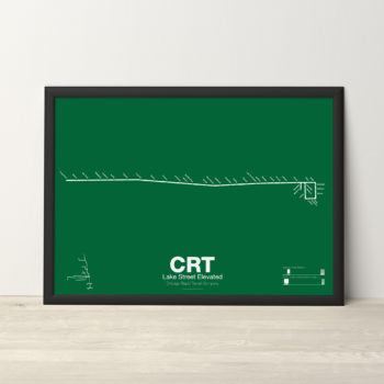
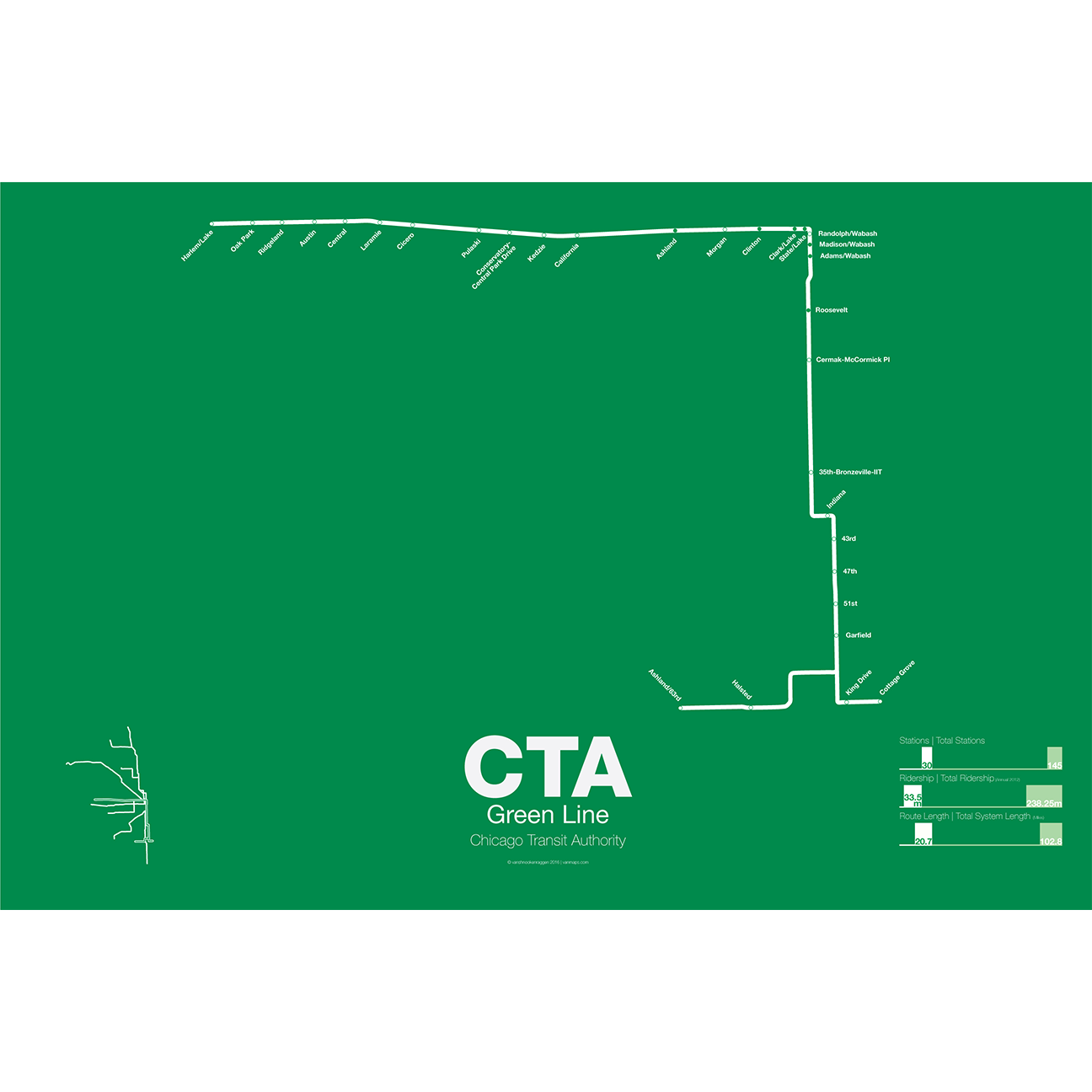
The Lake Street Elevated was Chicago’s second elevated line opening in 1893. In 1993 the CTA reorganized routes and color coded the new Lake St-South Side Lines as the Green Line.
Printed on Satin finish 80# cover stock – 220 GSM. Made in the USA! Standard production time is 5 Days. Please add more time for shipping.
-
 $30.00 – $80.00
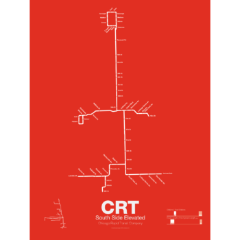
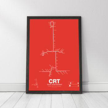
The South Side elevated opened in 1892 to serve the Columbian Exposition in 1893 and led to a building boom on the south side of Chicago. A number of branches were added to the line, to Englewood, Normal Park, Kenwood, and the Stock Yards. Today only the Englewood and Jackson Park branches remain while a number of stations have been closed due to low ridership.
Printed on Satin finish 80# cover stock – 220 GSM. Made in the USA! Standard production time is 5 Days. Please add more time for shipping.
-
 $30.00 – $80.00
The Green Line is the modern combination of two of the oldest sections of the Chicago “L”. The South Side elevated opened in 1892 to serve the Columbian Exposition in 1893 and led to a building boom on the south side of Chicago. A number of branches were added to the line, to Englewood, Normal Park, Kenwood, and the Stock Yards. Today only the Englewood and Jackson Park branches remain while a number of stations have been closed due to low ridership.
The Lake St elevated was Chicago’s second elevated line opening in 1893. When the State St Subway opened in 1947 it was originally used by the South Side trains to connect to the north side and when the Dan Ryan Branch opened in 1969 it was used by the Lake St Line. In 1993 the CTA reorganized routings and color coded the new Lake St-South Side Lines as the Green Line.
Printed on Satin finish 80# cover stock – 220 GSM. Made in the USA! Standard production time is 5 Days. Please add more time for shipping.
-
 $30.00 – $80.00
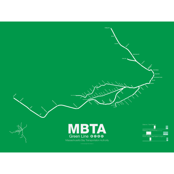
The Green Line is part of the oldest subway in the United States. The short section between Boylston St and Park St opened in 1897 as a way to divert heavy trolley traffic which came downtown from Allston, Brighton, Brookline, Jamaica Plane, Roxbury, and Dorchester. It was quickly expanded to North Station to serve trolley traffic from the northern suburbs.
As commuting patterns changed due in part to the success of the subway the Green Line was extended west to Kenmore Sq and in the 1940s southwest along Huntington Ave. As more and more commuters chose to travel in private automobiles ridership on the trolleys dropped. In 1959 the Riverside branch was opened along a former commuter rail line through Newton. A rebranding of the MBTA system in 1967 renamed the branches that were left as the A, B, C, D, and E branches. The A branch to Watertown Sq. only lasted two more years before finally being axed in 1969.
Boston College B Branch trains run along Commonwealth Ave to Government Center; Cleveland Cirlce C Branch trains run along Beacon St to North Station; Riverside D Branch trains run along the Riverside line through Newton to Government Center; Heath St E Branch trains run along Huntington Ave to Lechemere. Construction has begun on a long planned extension northwest through Somerville which will bring the E branch to Union Sq and the D to College Ave-Tufts University.
Printed on Satin finish 80# cover stock – 220 GSM. Made in the USA! Standard production time is 5 Days. Please add more time for shipping.
-
 $30.00 – $80.00
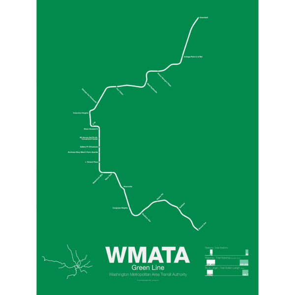
The Green Line was the final section of the original Washington Metro to open with trains not running until December 1991. While planning for the Green Line began at the same time as the rest of the system it was decided in 1977 to develop the route last. This decision sparked much controversy because the Green Line runs through areas of the city which are the poorest and most transit dependent.
Legal and funding issues dogged construction of the line. Station locations were also subject to much controversy and the ultimate route changed often. The northern section was to run in the median of the North Central Freeway but had to be changed when the freeway was canceled.
The Green Line shares its route through central D.C. with the Yellow Line. The first section ran from U St to Anacostia. Due to controversy over the route from U St to Fort Totten a small section of the Green Line from Fort Totten to Greenbelt opened first in 1993 with no physical connection to the other section of Green Line.
While the final section of subway from U St to Fort Totten was under construction some Green Line trains ran along the Red Line from West Hyattsville to Farragut North using a single non-revenue track connecting each line. In 1999 the connection between U St and Fort Totten was finally opened. In 2001 the Green Line was extended south to Branch Ave, thus completing the originally planned system 25 years after the first section was opened and 46 years after planning began.
Printed on Satin finish 80# cover stock – 220 GSM. Made in the USA! Standard production time is 5 Days. Please add more time for shipping.